 Block
From the record
14 National Register listings published here.
Sources: the National Register database, National Park Service
31 topographic sheets cover 24 settlements here, and 14 properties are on the National Register of Historic Places.
14 National Register listings published here.
Sources: the National Register database, National Park Service
Every property in this county listed on the National Register of Historic Places, with the year it was listed and the federal nomination document.
| Photograph | Property | Type | Listed | Reference |
|---|---|---|---|---|
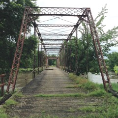 | Chambers Ford Bridge | structure | 1998 | 98000482 |
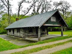 | Conant's Cabin and Park | building | 2000 | 00000920 |
 | First United Brethren Church | building | 2017 | 100000969 |
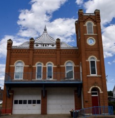 | Hope Fire Company Engine House | building | 1983 | 83000404 |
| King Tower Historic District | district | 2020 | 100004998 | |
| King Tower Historic District | district | 2020 | 100004998 | |
| Le Grand Bridge | structure | 1998 | 98000481 | |
 | Lincoln Highway Bridge | structure | 1978 | 78001263 |
| Round Barn, Buckingham Township | building | 1986 | 86001441 | |
 | Star-Clipper-Canfield Building and Winding Stairway | building | 1975 | 75000699 |
 | Tama County Courthouse | building | 1981 | 81000269 |
 | Tama County Jail | building | 1981 | 81000270 |
 | Wieting Theater | building | 1979 | 79000944 |
| John W. Young Round Barn | building | 1986 | 86001444 |
Every wildfire the federal occurrence database records inside this county: 443 of them, burning about 6,077 acres. None started naturally and 65 were recorded as arson. Each settlement page carries the fires within five miles of it.
| Reported cause | Fires |
|---|---|
| Debris and open burning | 193 |
| Missing data/not specified/undetermined | 149 |
| Arson/incendiarism | 65 |
| Equipment and vehicle use | 10 |
| Misuse of fire by a minor | 7 |
| Smoking | 5 |
| Power generation/transmission/distribution | 5 |
| Recreation and ceremony | 4 |
| Fireworks | 3 |
| Firearms and explosives use | 1 |
| Other causes | 1 |
The five largest, by the area the report gives. One of them was set deliberately.
| Date | Cause | Size | Reported by | Name on the report |
|---|---|---|---|---|
| 5 April 2004 | Debris and open burning | 400 acres | Sac and Fox Agency | MESQ4 |
| 2 April 2011 | Debris and open burning | 250 acres | Port Louisa National Wildlife Refuge | MORMON GROUND |
| 14 June 2016 | Missing data/not specified/undetermined | 250 acres | Iowa Department of Natural Resources | DNR WILDLIFE |
| 2 April 2003 | Missing data/not specified/undetermined | 200 acres | Sac and Fox Agency | 03-0000043 |
| 29 April 2018 | Arson/incendiarism | 175 acres | Sac and Fox Agency | 1776 E49 |
| 4 May 2004 | Missing data/not specified/undetermined | 175 acres | Sac and Fox Agency | E AVE MES |
| 30 March 2010 | Missing data/not specified/undetermined | 160 acres | Iowa Department of Natural Resources | 2456 305TH, TOLEDO, IOWA |
| 31 March 2003 | Missing data/not specified/undetermined | 150 acres | Sac and Fox Agency | 03-0000038 |
Every settlement page carries the fires within five miles of it - see the settlement index below.
The NOAA Storm Events Database holds 432 reports for this county, causing 1 death, 35 injuries and about $41,397,250 in recorded property damage. Each settlement page carries the reports that name it.
| Kind of event | Reports |
|---|---|
| Thunderstorm Wind | 153 |
| Hail | 109 |
| Heavy Rain | 57 |
| Tornado | 48 |
| Flood | 30 |
| Flash Flood | 19 |
| Funnel Cloud | 13 |
| Lightning | 3 |
The most serious of them, by death, then injury, then recorded damage. The accounts are quoted exactly as the forecast office filed them.
| When | Event | Place named | Harm | What the report says |
|---|---|---|---|---|
| April 1961 | Tornado (F3) | not stated | 1 killed, 6 hurt, $2,500,000 | no account filed |
| August 1993 | Thunderstorm Wind | Tama | 25 hurt, $5,000 | no account filed |
| April 1966 | Tornado (F3) | not stated | 4 hurt, $250,000 | no account filed |
| May 1989 | Tornado (F4) | not stated | $25,000,000 | no account filed |
| November 1975 | Tornado (F3) | not stated | $2,500,000 | no account filed |
| June 1998 | Thunderstorm Wind | Toledo | $1,000,000 | no account filed |
| July 2011 | Thunderstorm Wind | Garwin | $750,000 | Many power lines and trees down in the area, including one 3.5 foot diameter tree. A grain bin was flattened and at least part of a roof was in the yard. Windows were blown out and siding was ripped from the house. |
| July 2011 | Thunderstorm Wind | Clutier | $500,000 | Significant damage to the Clutier Fire Department building. Significant damage throughout the county. |
| June 1994 | Thunderstorm Wind | Tama | $500,000 | no account filed |
| May 2013 | Flash Flood | Traer Muni Arpt | $450,000 | Several roads were covered with water across the county. |
| June 2020 | Flood | Dysart | $400,000 | The public works director for La Porte City, IA reported over 75 homes impacted from the flooding with some homes reporting flooding impacts that extended to include both basements and part of the main level of the home. Flooding continued to block roads in town in areas that hadn't seen flood impacts since widespread flooding from the floods of 2008. |
| July 2011 | Thunderstorm Wind | Dysart | $350,000 | Numerous trees down, windows broken out and rescue crews called out. |
| July 2011 | Thunderstorm Wind | Toledo | $300,000 | A 180 foot radio tower was snapped with many trees down. |
| June 1983 | Tornado (F1) | not stated | $250,000 | no account filed |
| June 1983 | Tornado (F1) | not stated | $250,000 | no account filed |
| June 1979 | Tornado (F1) | not stated | $250,000 | no account filed |
| June 1979 | Tornado (F1) | not stated | $250,000 | no account filed |
| June 1979 | Tornado (F1) | not stated | $250,000 | no account filed |
| June 1979 | Tornado (F1) | not stated | $250,000 | no account filed |
| June 1979 | Tornado (F1) | not stated | $250,000 | no account filed |
| May 1977 | Tornado | not stated | $250,000 | no account filed |
| November 1975 | Tornado (F1) | not stated | $250,000 | no account filed |
| May 1971 | Tornado (F3) | not stated | $250,000 | no account filed |
| June 1964 | Tornado (F1) | not stated | $250,000 | no account filed |
| March 2022 | Tornado (EF2) | Tama Arpt | $200,000 | This tornado was the next in a series of tornadoes from the same supercell which tracked across central Iowa on this day. It formed southwest of the intersection of 370th Street and H Avenue and moved northeast. While remaining mostly over cropland and wooded areas, the tornado did impact a couple different residences with EF1 damage to outbuildings along Highway 63 south of Tama and then EF2 damage to a house on Highway E64 southeast of Tama where the roof was removed. Several cars were also tossed around at this location. The tornado then moved into the Iowa River valley producing tree damage with the tornado dissipating just shy of Highway 30 near P Avenue. |
| March 2019 | Flood | Lincoln | $200,000 | Multiple secondary roads closed in Tama County due to flooding. |
| July 2011 | Thunderstorm Wind | Toledo | $200,000 | Trees and power lines down all over the place. |
| July 2000 | Flash Flood | Countywide | $200,000 | no account filed |
| June 1998 | Thunderstorm Wind | Tama | $200,000 | no account filed |
| June 2014 | Tornado (EF2) | Traer | $150,000 | Damage was done to homes in the Traer area. |
| July 2011 | Thunderstorm Wind | Toledo | $150,000 | Barn and brick silo flattened. Many trees down, some 3 feet in diameter. |
| September 2018 | Flood | Montour | $100,000 | The Iowa River at Tama Highway E49 crested at 13.04 feet on 6 September 2018 at 0430 UTC. |
| May 2008 | Flood | Toledo | $100,000 | Numerous roads were under water around the county. |
| June 2007 | Flash Flood | Chelsea | $100,000 | no account filed |
| July 2000 | Flash Flood | Countywide | $100,000 | no account filed |
| June 1998 | Flood | Tama | $100,000 | no account filed |
| June 2011 | Tornado (EF0) | Clutier | $75,000 | A farm site on Highway V18 had tree tops snapped off. Minor damage occurred to the house with a gutter blown onto a truck. The roof was off of an outbuilding. The narrow damage path was very localized. In the town of Cluttier, one half mile to the southwest, large tree limbs were down. Debris and corn was directed to the north, consistent with small tornadic circulation at the farm site with EF0 damage. |
| June 1997 | Thunderstorm Wind | Gladbrook | $75,000 | no account filed |
| July 1995 | Thunderstorm Wind | Traer | $75,000 | no account filed |
| August 2000 | Lightning | Toledo | $60,000 | no account filed |
| September 2013 | Thunderstorm Wind | Chelsea | $50,000 | Winds estimated at 60 to 65 MPH. |
| July 2011 | Thunderstorm Wind | Gladbrook | $50,000 | Numerous trees down. Electricity out. |
| July 2011 | Thunderstorm Wind | Montour | $50,000 | Estimated winds of 70 to 100 MPH between Montour and Toledo. Road signs blown down with power outages. |
| June 2008 | Flood | Haven | $50,000 | All roads in and out of Chelsea were impassible due to flooding along the Iowa River. |
| June 2008 | Flash Flood | Montour | $50,000 | Flooding was causing evacuations in town. |
| June 2007 | Thunderstorm Wind | Tama | $50,000 | no account filed |
| July 2000 | Flash Flood | Garwin | $50,000 | no account filed |
| June 1998 | Thunderstorm Wind | Montour | $50,000 | no account filed |
| June 1994 | Hail | Tama | $50,000 | no account filed |
| March 2017 | Thunderstorm Wind | Chelsea | $40,000 | Emergency manager reported power lines down, house damage, and a barn blown down. |
| April 2003 | Lightning | Dysart | $40,000 | no account filed |
| June 2014 | Thunderstorm Wind | Chelsea | $35,000 | A corn crib was destroyed by high winds. |
| May 2001 | Tornado (F2) | Gladbrook | $35,000 | Tornado moved out of Grundy County into Tama County. Track was through mostly rural areas with limited damage. |
| July 1995 | Thunderstorm Wind | Gladbrook | $35,000 | no account filed |
| July 2011 | Thunderstorm Wind | Dysart | $30,000 | Tree limbs down and power out. A swing set was wrapped around a tree. |
| June 1998 | Thunderstorm Wind | Gladbrook | $30,000 | no account filed |
| July 2021 | Tornado (EF1) | Dysart | $25,000 | Tornado developed near the southwest corner of Dysart and moved east southeast. The tornado had a very broad circulation with smaller vorticies embedded within the larger circulation. The tornado produced mostly EF0 damage with some EF1 damage to houses on the far southwest side of town. The remainder of the path was in agricultural fields to the south of town. The tornado then moved from Tama county into Benton county. |
| July 2014 | Tornado (EF1) | Buckingham | $25,000 | Visually striking tornado moved through rural areas of Tama county. Debris was noted, farmstead was damaged, and numerous crops damaged. Track was well captured by satellite overflight. |
| June 2009 | Thunderstorm Wind | Tama | $25,000 | Widespread tree damage was reported. |
| June 2009 | Thunderstorm Wind | Montour | $25,000 | A semi-tractortrailer was blown off of U.S. Highway 30 by winds. |
The Survey's mineral resources record lists 13 workings inside this county. 2 still produce and 11 are closed or unrecorded. Each settlement page carries the workings within five miles of it.
| Commodity | Workings |
|---|---|
| Sand and Gravel, Construction | 6 |
| Stone, Crushed/Broken | 6 |
| Clay | 1 |
The least common of them first, because a county's hundredth gravel pit says nothing its first ten did not.
| Where | Site | Commodity | Status | Recorded |
|---|---|---|---|---|
| Gladbrook Brick and Tile Co. | Clay | Past Producer | ||
| Clutier Pit | Sand and Gravel, Construction | Past Producer | ||
| Fisher Quarry | Stone, Crushed/Broken | Past Producer | ||
| Harris Quarry | Stone, Crushed/Broken | Past Producer | ||
| Legrand Pit | Sand and Gravel, Construction | Past Producer | ||
| Manatt's Sand and Gravel, Inc. | Sand and Gravel, Construction | Producer | ||
| Montour Quarry | Stone, Crushed/Broken | Producer | ||
| Stevens Quarry | Stone, Crushed/Broken | Past Producer | ||
| Union Grove Quarry | Stone, Crushed/Broken | Past Producer | ||
| Unknown | Sand and Gravel, Construction | Past Producer | ||
| Unknown | Sand and Gravel, Construction | Past Producer | ||
| Unknown | Stone, Crushed/Broken | Past Producer | ||
| Wolleson Pit | Sand and Gravel, Construction | Past Producer |
Named settlements recorded in the Geographic Names Information System, each with the topographic sheets covering it. Villages, hamlets and abandoned places alike. Each is shown with the nearest named watercourse or landform and the survey quadrangle it falls on.
Buckingham township · 50612 · On Rock Creek · Buckingham quadrangle
10 sheets, 1954 to 1984
Buckingham township · 50675 · On Coon Creek · Traer quadrangle
9 sheets, 1954 to 1984
No longer a settlement
Spring Creek township · 50635 · On Devils Run · Gladbrook quadrangle
10 sheets, 1954 to 1984
Toledo township · 52339 · On Raven Creek · Montour quadrangle
8 sheets, 1954 to 1984
Indian Village township · 50173 · On Indian Creek · Montour quadrangle
8 sheets, 1954 to 1984
Geneseo township · 52224 · Dysart quadrangle
9 sheets, 1954 to 1984
No longer a settlement
York township · 52225 · Belle Plaine quadrangle
9 sheets, 1954 to 1984
No longer a settlement
Perry township · 50675 · On Little Coon Creek · Traer quadrangle
9 sheets, 1954 to 1984
No longer a settlement
The vanished settlements of Tama County: the places named above that are no longer on the map.