 Block
From the record
7 National Register listings published here.
Sources: the National Register database, National Park Service
32 topographic sheets cover 17 settlements here, and 7 properties are on the National Register of Historic Places.
7 National Register listings published here.
Sources: the National Register database, National Park Service
Every property in this county listed on the National Register of Historic Places, with the year it was listed and the federal nomination document.
| Photograph | Property | Type | Listed | Reference |
|---|---|---|---|---|
 | Bedford Commercial Historic District | district | 2002 | 02001032 |
 | Bedford House | building | 1977 | 77000560 |
 | Bedford Oil Company Station | building | 1999 | 99000831 |
 | Bedford Public Library | building | 1983 | 83000405 |
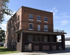 | Lenox Hotel | building | 2002 | 02001538 |
 | Lenox Round Barn | building | 1999 | 99000490 |
 | Taylor County Courthouse | building | 1981 | 81000271 |
Every wildfire the federal occurrence database records inside this county: 45 of them, burning about 586 acres. 1 started naturally and none was recorded as arson. Each settlement page carries the fires within five miles of it.
| Reported cause | Fires |
|---|---|
| Missing data/not specified/undetermined | 17 |
| Debris and open burning | 15 |
| Equipment and vehicle use | 9 |
| Smoking | 3 |
| Natural | 1 |
The five largest, by the area the report gives. None of them was recorded as arson.
| Date | Cause | Size | Reported by | Name on the report |
|---|---|---|---|---|
| 31 March 2014 | Debris and open burning | 200 acres | Iowa Department of Natural Resources | not named |
| 16 March 2015 | Debris and open burning | 80 acres | Iowa Department of Natural Resources | not named |
| 29 March 2008 | Missing data/not specified/undetermined | 40 acres | Iowa Department of Natural Resources | not named |
| 16 March 2015 | Debris and open burning | 31 acres | Iowa Department of Natural Resources | not named |
| 28 March 2013 | Debris and open burning | 25 acres | Iowa Department of Natural Resources | not named |
| 2 April 2011 | Missing data/not specified/undetermined | 20 acres | Iowa Department of Natural Resources | 1550 HWY 148, IA |
| 22 December 2020 | Equipment and vehicle use | 18 acres | Iowa Department of Natural Resources | not named |
| 12 April 2018 | Equipment and vehicle use | 15 acres | Iowa Department of Natural Resources | not named |
Every settlement page carries the fires within five miles of it - see the settlement index below.
The NOAA Storm Events Database holds 444 reports for this county, causing no deaths, 18 injuries and about $28,132,530 in recorded property damage. Each settlement page carries the reports that name it.
| Kind of event | Reports |
|---|---|
| Hail | 168 |
| Thunderstorm Wind | 133 |
| Heavy Rain | 67 |
| Tornado | 39 |
| Flash Flood | 16 |
| Flood | 10 |
| Funnel Cloud | 7 |
| Lightning | 4 |
The most serious of them, by death, then injury, then recorded damage. The accounts are quoted exactly as the forecast office filed them.
| When | Event | Place named | Harm | What the report says |
|---|---|---|---|---|
| May 1971 | Tornado (F3) | not stated | 12 hurt, $250,000 | no account filed |
| April 1981 | Tornado (F2) | not stated | 2 hurt, $2,500,000 | no account filed |
| March 1979 | Tornado (F3) | not stated | 1 hurt, $2,500,000 | no account filed |
| June 2017 | Thunderstorm Wind | New Market | 1 hurt, $40,000 | Three unsecured camper trailers were blown from their camp site into the lake. One minor injury reported. |
| May 1971 | Tornado (F2) | not stated | 1 hurt, $25,000 | no account filed |
| July 1995 | Thunderstorm Wind | Bedford | 1 hurt, $9,000 | no account filed |
| May 2011 | Tornado (EF1) | Lenox | $10,000,000 | This was the second tornado to move through Lenox on this day. This tornado formed on the southwest edge of town and moved due north into town along State Highway 49. It removed a roof from an old house and produced tree damage along its path. Shortly after removing the roof, the tornado began moving to the northwest and continued on this path prior to dissipating northwest of town. Maximum winds around 95 mph. |
| May 2011 | Tornado (EF1) | Lenox | $5,000,000 | This was the first of two tornadoes that moved through Lenox on this day. The tornado formed on south side of Lenox then proceeded to move through town. Worst damage was on the south side of town where a roof was partially removed from a house. Additional shingle damage and tree damage occurred as the tornado moved north northeast through the town. Max wind speeds were around 105 MPH. |
| June 1984 | Tornado (F3) | not stated | $2,500,000 | no account filed |
| May 1993 | Tornado (F2) | Bedford to | $500,000 | A line of thunderstorms moved into southwest Iowa during the evening hours. As the line progressed it turned into a large thunderstorm complex. Quite a bit of severe weather was associated with the complex while it was to the southwest of Iowa. As the storms moved into Iowa they weakened and produced mostly heavy rainfall and some small hail (pea to marble-size). One cell moved into Taylor County. Two farmsteads were hit by a tornado in the southwest corner of the county. The tornado touched down in sections 21 and 28 of Polk Township. Trees were twisted with shingles being driven into the trees. Damage on one farmstead totaled approximately $70,000 with two garages taken out and damage done to the farmhouse. The second farm sustained about $35,000 damage with most done to outbuildings. Reports indicated one piece of tin from the two farmsteads that were hit was found two to three miles away. The same storm caused damage to grain bins and silos to the southwest of Taylor County in Missouri. The tornado remained on the ground, at least intermittently, to a point west-northwest of Bedford. At that point it lifted, just before crossing Highway 2. The track would have taken the tornado through the town of Gravity. Fortunately, after it hit the two farmsteads in the southwest part of the county, it tracked across open countryside. |
| April 1999 | Tornado (F2) | New Market | $500,000 | no account filed |
| July 1958 | Tornado (F3) | not stated | $250,000 | no account filed |
| May 1998 | Thunderstorm Wind | Lenox | $200,000 | no account filed |
| July 2016 | Thunderstorm Wind | Platteville | $150,000 | Emergency Manager reported roof off of building with an estimated 150,000 dollars in damages. Time determined from EM estimate and radar. |
| August 2011 | Thunderstorm Wind | Gravity | $150,000 | Tree limbs up to 12 inches in diameter and power lines were down along a line from Bedford to Gravity. Extensive tree damage along Highway 2 around Bedford and a roof was blown off of a business in Bedford. Siding was stripped off of the north and west side of a house there. |
| June 2010 | Flood | Bedford Arpt | $100,000 | Water over numerous roads. |
| April 1999 | Tornado (F1) | Bedford | $100,000 | very intermittent track |
| May 2007 | Thunderstorm Wind | Gravity | $100,000 | no account filed |
| August 2006 | Flash Flood | Countywide | $100,000 | no account filed |
| May 1997 | Lightning | Lenox | $100,000 | no account filed |
| June 2014 | Thunderstorm Wind | Lenox | $90,000 | A large shed was completely destroyed just over two miles east of Lenox. Confirmed by a NWS Storm Survey. |
| November 2015 | Tornado (EF0) | Conway | $80,000 | This tornado crossed 3 counties in southern Iowa. This is segment number one in Taylor county. This long track tornado damaged a number of farmsteads along its 22 mile long path. The tornado was at its strongest in NW Ringgold County where EF-1 damage was found. The beginning and end sections of the track were narrow and intermittent. The narrow tornado also clipped the town of Clearfield to the NW early in its life. The tornado crossed into Ringgold county. |
| June 2017 | Tornado (EF2) | Bedford Arpt | $75,000 | Large wedge tornado moved across southern Taylor County. The tornado remained in rural areas with primarily tree and crop damage. A few structures were also hit with some minor damage to a house and one old outbuilding nearly destroyed. Most intense damage occurred in the later half of the tornado path where EF2 damage was observed as 4 large wooden electrical power line towers where destroyed along with decimating a nearby grove of trees. |
| August 2007 | Thunderstorm Wind | Clearfield | $75,000 | High winds destroyed a grain bin and greenhouse at a local residence just north of town. Several trees and power lines were downed in the town of Clearfield. |
| August 2007 | Lightning | Clearfield | $75,000 | no account filed |
| August 2000 | Thunderstorm Wind | Bedford | $75,000 | no account filed |
| August 2000 | Thunderstorm Wind | Bedford | $75,000 | no account filed |
| July 1995 | Thunderstorm Wind | Sharpsburg | $55,000 | no account filed |
| July 2015 | Flash Flood | Bedford | $50,000 | Law Enforcement reported a pond in town has completely filled and is overflowing and running across the road. Depth of the water is unknown. |
| June 2014 | Thunderstorm Wind | Lenox | $50,000 | Wind continued strong for nearly 12 minutes and produced damaging gusts from time to time. Farm building damaged. |
| June 2014 | Thunderstorm Wind | Clearfield | $50,000 | A large camper trailer was blown over. Several trees were destroyed. |
| August 2011 | Hail | Gravity | $50,000 | Baseball size hail reported. |
| June 2010 | Hail | Clearfield | $50,000 | Golf ball to near baseball size hail reported. |
| September 2010 | Hail | Bedford | $50,000 | Hail ranged from one half inch to two and one half inches in diameter. |
| June 2008 | Tornado (EF0) | Gravity | $50,000 | The Taylor County Emergency Manager reports tornado damage. This was relayed via HAM radio. Windows were blown out of houses and numerous trees were down and twisted. |
| June 2010 | Flood | Conway | $50,000 | no account filed |
| August 2007 | Thunderstorm Wind | Bedford | $50,000 | no account filed |
| April 2006 | Thunderstorm Wind | Lenox | $50,000 | no account filed |
| May 2004 | Thunderstorm Wind | Sharpsburg | $50,000 | no account filed |
| April 2002 | Hail | Bedford | $50,000 | no account filed |
| May 1999 | Tornado (F1) | Bedford | $50,000 | no account filed |
| May 1996 | Flood | Bedford | $50,000 | no account filed |
| April 1994 | Thunderstorm Wind | Bedford | $50,000 | no account filed |
| September 1993 | Thunderstorm Wind | Gravity | $50,000 | no account filed |
| September 1993 | Hail | Gravity | $50,000 | no account filed |
| September 1993 | Hail | Bedford | $50,000 | no account filed |
| April 1996 | Thunderstorm Wind | New Market | $35,000 | no account filed |
| August 2022 | Thunderstorm Wind | Sharpsburg | $30,000 | An outbuilding destroyed with walls of the structure falling on the adjacent home. Images relayed via broadcast media on social media. Delayed report, time estimated via social media. |
| June 2017 | Tornado (EF1) | New Market | $30,000 | Short tornado embedded within a large area of strong winds. Tornado tracked southeast through a cornfield before encountering a farmstead. It snapped and blew over trees in a grove just northwest of the farm which is where the EF1 damage occurred. It proceeded to destroy a hoop building on the farm and blew two empty grain bins off their foundations. Other tree damage occurred as well. The tornado then produced some tree damage in a grove of trees along Highway 2 before dissipating. |
| June 2010 | Thunderstorm Wind | Gravity | $30,000 | At least part of a roof was blown off of a home. |
| June 2010 | Thunderstorm Wind | Bedford | $30,000 | Taylor County Emergency Manager relayed roof damage occurred south of Highway 2 on Highland Ave. |
| June 2005 | Thunderstorm Wind | Lenox | $30,000 | no account filed |
| April 2002 | Hail | Bedford | $30,000 | no account filed |
| June 2002 | Thunderstorm Wind | Siam | $30,000 | no account filed |
| July 1999 | Flood | Bedford | $30,000 | no account filed |
| March 1996 | Thunderstorm Wind | Bedford | $30,000 | no account filed |
| October 2019 | Thunderstorm Wind | Bedford Arpt | $25,000 | Trained spotter reported 3 or 4 large trees uprooted, including one that fell on the spotter's house. They also noted several other tree limbs down throughout the neighborhood. Time estimated from radar. |
| April 2016 | Tornado (EF0) | Clearfield | $25,000 | This brief tornado damaged one farmstead where damage was high EF-0. One outbuilding collapsed, several trees were damaged, and a camper was flipped. |
| June 2014 | Thunderstorm Wind | Clearfield | $25,000 | Public reported golf ball size hail and torrential rainfall. A car window was shattered. |
| June 2008 | Flash Flood | Bedford | $25,000 | Rainfall of 1.75 inches was reported in less than an hour, causing extensive street flooding in Bedford. More than 6 inches of water was flowing through streets through the crossing of Highway 148. |
The Survey's mineral resources record lists 3 workings inside this county. 2 still produce and 1 is closed or unrecorded. Each settlement page carries the workings within five miles of it.
| Commodity | Workings |
|---|---|
| Stone, Crushed/Broken | 3 |
The least common of them first, because a county's hundredth gravel pit says nothing its first ten did not.
| Where | Site | Commodity | Status | Recorded |
|---|---|---|---|---|
| Bedford Quarry | Stone, Crushed/Broken | Past Producer | ||
| Nash Quarry and Mill | Stone, Crushed/Broken | Producer | ||
| One Hundred and Two Quarry | Stone, Crushed/Broken | Producer |
Named settlements recorded in the Geographic Names Information System, each with the topographic sheets covering it. Villages, hamlets and abandoned places alike. Each is shown with the nearest named watercourse or landform and the survey quadrangle it falls on.
Marshall township · 50833 · On Hog Branch · Merle Junction quadrangle
8 sheets, 1955 to 1985