 Block
From the record
15 National Register listings published here.
Sources: the National Register database, National Park Service
43 topographic sheets cover 33 settlements here, and 15 properties are on the National Register of Historic Places.
15 National Register listings published here.
Sources: the National Register database, National Park Service
Every property in this county listed on the National Register of Historic Places, with the year it was listed and the federal nomination document.
| Photograph | Property | Type | Listed | Reference |
|---|---|---|---|---|
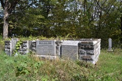 | Lorenzo S. Coffin Burial Plot | site | 1977 | 77000566 |
 | Corpus Christi Church | building | 1976 | 76000812 |
| Dolliver Memorial State Park, Entrance Area (Area A) | building | 1990 | 90001684 | |
| Dolliver Memorial State Park, Picnic, Hiking & Maintenance Area (Area B) | district | 1990 | 90001685 | |
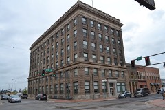 | First National Bank Building | building | 2003 | 03000061 |
 | Fort Dodge Downtown Historic District | district | 2010 | 10000918 |
| Fort Dodge Junior High School | building | 2015 | 15000730 | |
| Fort Dodge Senior High School | building | 2015 | 15000731 | |
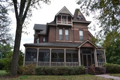 | Oak Hill Historic District | district | 1977 | 77000567 |
 | Oakland Cemetery | district | 2000 | 00000984 |
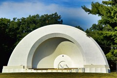 | Oleson Park Music Pavilion | structure | 2003 | 03000357 |
| Sacred Heart Catholic Church | building | 2022 | 100008305 | |
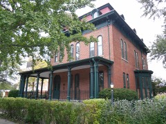 | Vincent House | building | 1973 | 73000743 |
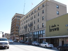 | Wahkonsa Hotel | building | 2008 | 08000443 |
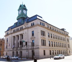 | Webster County Courthouse | building | 1981 | 81000274 |
Every wildfire the federal occurrence database records inside this county: 46 of them, burning about 438 acres. None started naturally and 4 were recorded as arson. Each settlement page carries the fires within five miles of it.
| Reported cause | Fires |
|---|---|
| Missing data/not specified/undetermined | 25 |
| Debris and open burning | 8 |
| Smoking | 6 |
| Arson/incendiarism | 4 |
| Equipment and vehicle use | 2 |
| Misuse of fire by a minor | 1 |
The five largest, by the area the report gives. None of them was recorded as arson.
| Date | Cause | Size | Reported by | Name on the report |
|---|---|---|---|---|
| 31 March 2015 | Debris and open burning | 80 acres | Iowa Department of Natural Resources | not named |
| 30 April 2018 | Missing data/not specified/undetermined | 60 acres | Iowa Department of Natural Resources | not named |
| 1 April 2015 | Smoking | 45 acres | Iowa Department of Natural Resources | not named |
| 5 April 2007 | Missing data/not specified/undetermined | 40 acres | Iowa Department of Natural Resources | not named |
| 9 April 2019 | Debris and open burning | 30 acres | Iowa Department of Natural Resources | not named |
| 28 March 2012 | Debris and open burning | 30 acres | Iowa Department of Natural Resources | not named |
| 8 October 2011 | Missing data/not specified/undetermined | 18 acres | Iowa Department of Natural Resources | DAYTON OAKS CAMP, TAYLOR AVE., 2 MI. E OF DAYTON, |
| 8 October 2020 | Missing data/not specified/undetermined | 15 acres | Iowa Department of Natural Resources | not named |
Every settlement page carries the fires within five miles of it - see the settlement index below.
The NOAA Storm Events Database holds 759 reports for this county, causing no deaths, 26 injuries and about $19,116,180 in recorded property damage. Each settlement page carries the reports that name it.
| Kind of event | Reports |
|---|---|
| Hail | 226 |
| Thunderstorm Wind | 216 |
| Heavy Rain | 111 |
| Flood | 68 |
| Tornado | 65 |
| Flash Flood | 56 |
| Funnel Cloud | 14 |
| Lightning | 3 |
The most serious of them, by death, then injury, then recorded damage. The accounts are quoted exactly as the forecast office filed them.
| When | Event | Place named | Harm | What the report says |
|---|---|---|---|---|
| May 1977 | Tornado (F4) | not stated | 14 hurt, $250,000 | no account filed |
| June 1967 | Tornado (F2) | not stated | 5 hurt, $250,000 | no account filed |
| May 1977 | Tornado (F2) | not stated | 4 hurt, $2,500,000 | no account filed |
| June 1997 | Thunderstorm Wind | Badger | 2 hurt, $100,000 | no account filed |
| June 1974 | Tornado (F1) | not stated | 1 hurt, $25,000 | no account filed |
| March 2019 | Flood | Clare | $1,000,000 | Emergency reported water had started to rise along Riverside Trail between Fort Dodge and Otho, and will impact residential areas. Webster County has begun to evacuate some residents. The emergency manager also noted ice jam action likely starting near Lehigh.|The ice jam near Lehigh on the Des Moines River ended up flooding many homes and structures in the town of Lehigh. Many roads were closed as well. |
| June 2010 | Flash Flood | (Fod)Ft Dodge Muni A | $500,000 | Standing water across much of the city. Water under Highway 169 underpass at railroad bridge. Three feet of water at the Crossroads Mall. Flooding along 1st Ave South and 2nd Ave North and at North 21st St. Many other reports as well. |
| August 2009 | Hail | Otho | $500,000 | Windows broken in houses. |
| June 2008 | Flood | Ft Dodge | $500,000 | no account filed |
| March 2007 | Flash Flood | Ft Dodge | $500,000 | no account filed |
| November 2005 | Tornado (F2) | Dayton | $450,000 | Tornado moved in from Boone County, then tracked into Hamilton County. |
| September 1999 | Thunderstorm Wind | Roelyn | $440,000 | no account filed |
| August 2010 | Flash Flood | Clay Works | $250,000 | Highway 169 was closed and impassable at the intersection of U.S. 20 Business in southern Fort Dodge. |
| July 2010 | Flash Flood | Ft Dodge | $250,000 | Flooding was reported along 6th Ave North. Along 2nd Ave North there was flooding with water up to the windows of cars and 5th Ave South had to be closed. |
| July 2010 | Flash Flood | Ft Dodge | $250,000 | Two to 3 feet of water was reported flowing in numerous intersections. |
| August 2009 | Thunderstorm Wind | Callender | $250,000 | Extensive tree, window, roof, and crop damage from high winds and inch diameter. Large hail remained on the ground in the Callender area for a few hours. |
| August 2009 | Hail | Kalo | $250,000 | Spotter reports larger than golf ball size hail. It fell at Nelson Ave and Woodmans Hollow Road north of Coalville. Small branches were also blown down by high winds. |
| June 2010 | Flood | Ft Dodge | $250,000 | no account filed |
| August 2009 | Hail | Brushy | $250,000 | no account filed |
| April 2007 | Flood | (Fod)Ft Dodge Muni A | $250,000 | no account filed |
| August 1988 | Tornado (F1) | not stated | $250,000 | no account filed |
| December 2021 | Tornado (EF2) | Lena | $200,000 | This tornado moved into Webster County from Greene County. The tornado entered the county southwest of Lanyon and passed just west of Harcourt continuing northeast before dissipating between Lehigh and Otho. This tornado snapped several large utility poles on its path across the county along with destroying a few outbuildings. |
| March 2019 | Flood | Clare | $200,000 | Emergency manager reported most gravel roads cannot be driven on and several blacktop roads covered in water. At the time, low visibility making it hard to see flooded roadways. County has taken most utility trucks off the roads due to flood dangers. |
| May 2018 | Flood | Roberts | $200,000 | The Des Moines River at Fort Dodge crested at 11.44 feet on 4 May 2018 at 22:30 UTC. |
| February 2016 | Flash Flood | (Fod)Ft Dodge Muni A | $200,000 | Law Enforcement reported flooding in the Riverdale Drive area and near the Scenic Drive and Breen Road areas as well. |
| August 2014 | Tornado (EF1) | Dayton | $200,000 | This small but potent tornado formed just over 3 miles north of Dayton and tracked nearly due east, destroying one hog confinement building and leaving a pronounced trail through multiple corn fields. The tornado weakened midway into its track, but still left a path 20 yards wide through several other corn fields before doing some minor tree damage at the end of its track. Tornado was surveyed but track lengthened after high resolution satellite imagery showed additional damage and path length. |
| March 2010 | Flash Flood | (Fod)Ft Dodge Muni A | $200,000 | Flash flood due to an ice jam along the Des Moines River near Fort Dodge. Two to three feet of flowing water was reported throughout the Breen Addition just north of Fort Dodge, with several houses receiving water up to the first panel of garage doors. |
| March 2010 | Flash Flood | Ft Dodge | $200,000 | The Emergency Manager reports that water was rising rapidly in the Riverdale area with large chunks of ice moving and water flowing rapidly. Flooding continues in the Breen Addition as well. |
| August 2010 | Flood | Gowrie | $200,000 | Several gravel roads closed by water in the Gowrie area that did not have a history of flooding. Overnight rainfall was 1.7 inches, with 7.7 inches in past 3 days. |
| February 2011 | Flood | Ft Dodge | $200,000 | no account filed |
| February 2011 | Flash Flood | Ft Dodge | $200,000 | no account filed |
| March 2010 | Flood | Ft Dodge | $200,000 | no account filed |
| May 1998 | Hail | Harcourt | $150,000 | Hail covered the ground |
| April 1998 | Flood | Ft Dodge | $150,000 | no account filed |
| May 1998 | Thunderstorm Wind | Gowrie | $150,000 | no account filed |
| March 2019 | Flood | Lehigh | $100,000 | Emergency manager reported water over the road has resulted in the evacuation of 2 to 3 homes at Nelson Ave and Riverside Trail near Coalville. |
| May 2019 | Flood | Roberts | $100,000 | The Des Moines River at Fort Dodge crested at 11.44 feet on 25 May 2019 at 22:45 UTC. |
| March 2018 | Flood | Roberts | $100,000 | The Des Moines River at Fort Dodge crested at 14.61 ft on 5 March 2018 at 0645 UTC. |
| June 2018 | Flood | Roberts | $100,000 | The Des Moines River at Fort Dodge crested 4 times during the period the river was in flood. It remained in flood into July. The first crest was at 11.24 feet on 21 June 2018 at 07:00 UTC, the second at 12.75 feet on 23 June 2018 at 04:45 UTC, the third at 12.88 feet on 24 June 2018 at 21:15 UTC, and the fourth crest at 20.26 feet on 27 June 2018 at 22:15 UTC. |
| July 2018 | Flood | Roberts | $100,000 | The Des Moines River at Fort Dodge went into flood in late June and remained in flood through early July. The river crested twice in July. The first crest was at 13.43 feet on 1 July 2018 at 21:45Z, and the second crest was at 12.55 feet on 6 July 2018 at 20:15 UTC. |
| September 2018 | Flood | Lanyon | $100,000 | The Des Moines River at Stratford crested at 23.08 feet on 24 September 2018 at 1245 UTC. |
| September 2018 | Flood | Roberts | $100,000 | The Des Moines River at Fort Dodge crested at 14.14 feet on 23 September 2018 at 1645 UTC. |
| August 2015 | Flash Flood | Dayton | $100,000 | Public reported major flash flooding ongoing throughout the town of Dayton due to Skillet Creek. Fairground, local golf course, and campground are all inundated with at least 5 feet of flowing water. |
| March 2010 | Flash Flood | (Fod)Ft Dodge Muni A | $100,000 | Flash flooding due to ice jams along Scenic Drive near the Des Moines River west bank. |
| June 2010 | Heavy Rain | Ft Dodge | $100,000 | There was 3.5 inches of rainfall since 2200 CST. |
| August 2010 | Flash Flood | Burnside | $100,000 | Water flowing over gravel roads with 3.9 inches of rainfall measured at 1930 CST. Additional rain from 2000 to 2020 CST. |
| August 2010 | Flash Flood | Burnside | $100,000 | Washout in Dolliver State Park. |
| June 2008 | Flash Flood | Ft Dodge | $100,000 | Streets were nearly impassible in town, with manhole covers lifting off due to water. |
| June 2008 | Flash Flood | Ft Dodge | $100,000 | Major street flooding with 4 feet of water for several blocks near 5th Ave. Several cars were stalled in the flood waters. |
| August 2007 | Flash Flood | Clare | $100,000 | Highway 169 north of Fort Dodge was closed by water running over the road. Highway 20 underpass closed by running water. |
| June 2004 | Tornado (F0) | Otho | $100,000 | Tornado touched down south of Otho and caused extensive damage to two farmsteads. |
| June 2014 | Hail | Ft Dodge | $100,000 | no account filed |
| May 2013 | Flood | Ft Dodge | $100,000 | no account filed |
| June 2010 | Lightning | Clay Works | $100,000 | no account filed |
| August 2006 | Thunderstorm Wind | Callender | $100,000 | no account filed |
| June 2005 | Flash Flood | Countywide | $100,000 | no account filed |
| May 1996 | Thunderstorm Wind | Ft Dodge | $100,000 | no account filed |
| May 2024 | Thunderstorm Wind | Ft Dodge | $75,000 | Emergency manager reported trees down on power lines through town. |
| December 2021 | Tornado (EF2) | Evanston | $75,000 | This tornado started on the east side of the Des Moines River valley southwest of Duncombe and moved quickly northeast. The tornado snapped several power poles near the intersection of Taylor Avenue and 220th Street west of Duncombe. Another outbuilding was destroyed northwest of Duncombe near the intersection of 210th Street and the Canadian National Railway. The tornado lifted not long afterwards. |
| June 2014 | Thunderstorm Wind | Burnside | $75,000 | Widespread damage to a farm southeast of Otho. Damage to trees and outbuildings. Roof removed from one building. Damage was also reported to a home. |
The Survey's mineral resources record lists 73 workings inside this county. 20 still produce and 53 are closed or unrecorded. Each settlement page carries the workings within five miles of it.
| Commodity | Workings |
|---|---|
| Sand and Gravel, Construction | 38 |
| Gypsum-Anhydrite | 26 |
| Stone, Crushed/Broken | 5 |
| Perlite | 3 |
| Clay | 3 |
| Flagstone | 1 |
The least common of them first, because a county's hundredth gravel pit says nothing its first ten did not.
| Where | Site | Commodity | Status | Recorded |
|---|---|---|---|---|
| Unknown | Flagstone | Past Producer | ||
| Fort Dodge Plant | Gypsum-Anhydrite, Perlite | Past Producer | ||
| Johnston Clay Works | Clay | Past Producer | ||
| Kalo Brick and Tile Co. | Clay | Past Producer | ||
| National Gypsum Plant | Gypsum-Anhydrite, Perlite | Producer | ||
| U S Gypsum Plant | Gypsum-Anhydrite, Perlite | Producer | ||
| Vincent Clay Products Co. | Clay | Past Producer | ||
| Fort Dodge Mine | Stone, Crushed/Broken | Producer | ||
| Lehigh Pit & Plant | Stone, Crushed/Broken | Producer | ||
| Mitchell Quarry | Stone, Crushed/Broken | Producer | ||
| Northwest Limestone Quarry | Stone, Crushed/Broken | Producer | ||
| Unknown | Stone, Crushed/Broken | Past Producer | ||
| Blandon Mine | Gypsum-Anhydrite | Past Producer | ||
| Breen-Jordison Quarry | Gypsum-Anhydrite | Past Producer | ||
| Cardiff Gypsum | Gypsum-Anhydrite | Past Producer | ||
| Celotex Gypsum Plant | Gypsum-Anhydrite | Producer | ||
| Celotex Gypsum Quarry | Gypsum-Anhydrite | Producer | ||
| Certain-Teed Products Corp. Mine | Gypsum-Anhydrite | Past Producer | ||
| Fort Dodge Gypsum Co. | Gypsum-Anhydrite | Past Producer | ||
| Fort Dodge Mill | Gypsum-Anhydrite | Producer | ||
| Fort Dodge Pit Georgia Pacific | Gypsum-Anhydrite | Producer | ||
| Fort Dodge Pit & Plant | Gypsum-Anhydrite | Producer | ||
| Fort Dodge Plant Georgia Pacific | Gypsum-Anhydrite | Producer | ||
| Georgia Pacific Gypsum Quarry | Gypsum-Anhydrite | Producer | ||
| Hawkeye Gypsum Co. Mine | Gypsum-Anhydrite | Past Producer | ||
| Kaufman George Pit | Gypsum-Anhydrite | Producer | ||
| Louie Smith Gypsum Mine | Gypsum-Anhydrite | Past Producer | ||
| Mineral City Mine | Gypsum-Anhydrite | Past Producer | ||
| National Gypsum Quarry | Gypsum-Anhydrite | Producer | ||
| North Welles Quarry | Gypsum-Anhydrite | Unknown | ||
| South Welles Quarry | Gypsum-Anhydrite | Past Producer | ||
| Universal Gypsum and Lime Co. Mine | Gypsum-Anhydrite | Past Producer | ||
| Unknown | Gypsum-Anhydrite | Past Producer | ||
| Unknown | Gypsum-Anhydrite | Unknown | ||
| Wasem Plaster Company | Gypsum-Anhydrite | Past Producer | ||
| Black Pit | Sand and Gravel, Construction | Past Producer | ||
| Briggs Pit | Sand and Gravel, Construction | Past Producer | ||
| Casey Pit | Sand and Gravel, Construction | Past Producer | ||
| Casey Pit | Sand and Gravel, Construction | Producer | ||
| Condon Pit | Sand and Gravel, Construction | Past Producer | ||
| Croft Sand Pit | Sand and Gravel, Construction | Producer | ||
| Dutcher Pits | Sand and Gravel, Construction | Past Producer | ||
| Faro Pit | Sand and Gravel, Construction | Past Producer | ||
| Gilpin Pit | Sand and Gravel, Construction | Producer | ||
| Gilpin Pit | Sand and Gravel, Construction | Past Producer | ||
| Gilpin Pit | Sand and Gravel, Construction | Past Producer | ||
| Herrington Pit | Sand and Gravel, Construction | Past Producer | ||
| Hoover Pits | Sand and Gravel, Construction | Past Producer | ||
| Hudson Pit | Sand and Gravel, Construction | Past Producer | ||
| Hudson/Otho Pit | Sand and Gravel, Construction | Past Producer | ||
| Iles Pit | Sand and Gravel, Construction | Past Producer | ||
| Joe Hammer Pit | Sand and Gravel, Construction | Past Producer | ||
| Jondle Pit | Sand and Gravel, Construction | Past Producer | ||
| Kelling Pit | Sand and Gravel, Construction | Past Producer | ||
| Knox Pit | Sand and Gravel, Construction | Past Producer | ||
| Lohr Pit | Sand and Gravel, Construction | Past Producer | ||
| Mccalley Pit | Sand and Gravel, Construction | Past Producer | ||
| Northwest Pit & Mine | Sand and Gravel, Construction | Producer | ||
| Peterson Pit | Sand and Gravel, Construction | Past Producer | ||
| Spilka Pit | Sand and Gravel, Construction | Past Producer | ||
| Tobin Pit | Sand and Gravel, Construction | Past Producer | ||
| Unknown | Sand and Gravel, Construction | Past Producer | ||
| Unknown | Sand and Gravel, Construction | Past Producer | ||
| Unknown | Sand and Gravel, Construction | Past Producer | ||
| Unknown | Sand and Gravel, Construction | Past Producer | ||
| Unknown | Sand and Gravel, Construction | Past Producer | ||
| Unknown | Sand and Gravel, Construction | Past Producer | ||
| Unknown | Sand and Gravel, Construction | Past Producer | ||
| Unknown | Sand and Gravel, Construction | Past Producer | ||
| Unknown | Sand and Gravel, Construction | Past Producer | ||
| Unknown | Sand and Gravel, Construction | Past Producer | ||
| Vanderhoff Pit | Sand and Gravel, Construction | Past Producer | ||
| Wrede Pit | Sand and Gravel, Construction | Producer |
Named settlements recorded in the Geographic Names Information System, each with the topographic sheets covering it. Villages, hamlets and abandoned places alike. Each is shown with the nearest named watercourse or landform and the survey quadrangle it falls on.
Pleasant Valley township · 50501 · On Holliday Creek · Fort Dodge South quadrangle
11 sheets, 1923 to 1993
Cooper township · 50501 · Fort Dodge South quadrangle
11 sheets, 1923 to 1993
No longer a settlement
Washington township · 50532 · Duncombe quadrangle
9 sheets, 1954 to 1993
No longer a settlement
Fort Dodge city · 50501 · On Elkhorn Creek · Fort Dodge South quadrangle
11 sheets, 1923 to 1993
Pleasant Valley township · 50501 · On Gypsum Creek · Fort Dodge South quadrangle
11 sheets, 1923 to 1993
Douglas township · 50501 · On Elkhorn Creek · Fort Dodge South quadrangle
11 sheets, 1923 to 1993
No longer a settlement
The vanished settlements of Webster County: the places named above that are no longer on the map.