
BlockBefore
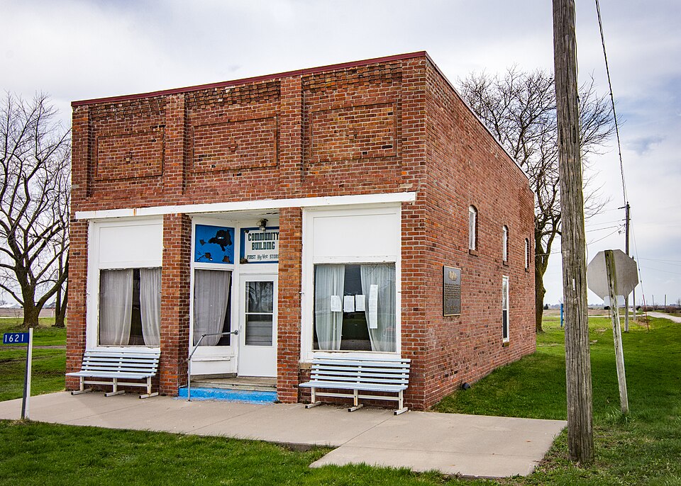
Photograph of Beaconsfield Supply Store
Photograph by Mclarenj, CC BY-SA 4.0. Via Wikimedia Commons.

Beaconsfield Supply Store

Listed on the National Register of Historic Places in 2007.

From the record

“The Beaconsfield Supply Store, also known as the Beaconsfield Community Building, is a one-story brick building in rural Ringgold County, Iowa, United States. Built in 1916, it became the birthplace of the Hy-Vee chain of stores when Charles Hyde and David Vredenburg opened a general store together in 1930.”

Wikipedia article Beaconsfield Supply Store, CC BY-SA 4.0.

One of 6 National Register listings published here for Ringgold County · listed in 2007 · category: Building.

Sources: the Wikipedia article · the case file at the National Archives · the National Register database, National Park Service

The listing

  • What is counted as historic. The nomination lists 1 building as contributing to the listing.
  • Address. 1621 Main St., Beaconsfield, 50074
  • When was it listed? May 2007
  • Category. building
  • Township. Monroe township
  • National Register reference number. 07000451 - the number the National Park Service assigned this property when it was listed, and the key its nomination file is catalogued under at the National Archives.

Fires near this property

2 since 2008

Regional context, not property-specific evidence. The federal wildfire occurrence database lists 2 fires within 5 miles of Beaconsfield Supply Store in 2008, burning about 4 acres in total. None started naturally. None was recorded as arson. Distance is straight-line from the map coordinates, so a fire counted here may appear on a neighbouring settlement's page as well.

Reported cause Fires
Missing data/not specified/undetermined2

The most recent of them, most recent first, with the day each was reported and the service that recorded it.

DateCause SizeReported by Name on the report
27 April 2008Missing data/not specified/undeterminedunder an acreIowa Department of Natural Resourcesnot named
30 March 2008Missing data/not specified/undetermined3.0 acresIowa Department of Natural Resourcesnot named

Every fire recorded in Ringgold County

Storms near this property

27 since 1996

Regional context, not property-specific evidence. The National Weather Service names Beaconsfield, the town this property stands in, in 27 storm reports between 1996 and 2021: 13 heavy rain, 6 hail, 5 thunderstorm wind, 2 flash flood. No death or injury is recorded in these reports. Each account below is quoted exactly as the forecast office filed it, from the NOAA Storm Events Database, and each date opens the federal record of that event.

WhenEvent Place namedHarm What the report says
April 2013Thunderstorm WindBeaconsfield$75,000One inch diameter hail along with damage to house roofs and vehicles.
April 2013HailBeaconsfield$25,000Hail still in ditches the next morning. Siding of houses damaged and plastic on shed damaged with window screens also torn.
July 2008Flash FloodBeaconsfield$25,000Water over County Road J25 due to Lotts Creek between County Highway P64 and County Highway P68 just north of Kellerton.
April 2013Flash FloodBeaconsfield$20,000Water over County Road P64 and also 210th Street north of Highway 2 with roads impassible.
June 2014Thunderstorm WindBeaconsfield$10,000Loss of metal roof material from a farm outbuilding.
August 2007Thunderstorm WindBeaconsfield$10,000Several large trees were down by high winds.
July 2001HailBeaconsfield$10,000no account filed
July 2001HailBeaconsfield$2,000no account filed
April 1999Thunderstorm WindBeaconsfield$2,000no account filed
May 1996HailBeaconsfield$2,000no account filed
September 2005HailBeaconsfield$1,000no account filed
June 2021Heavy RainBeaconsfield-Coop observer reported 3.46 inches of rain in 24 hours.
July 2021Heavy RainBeaconsfield-A 24 hour rainfall report of 2.62 inches.
September 2019Heavy RainBeaconsfield-Coop observer recorded heavy rainfall of 2.10 inches over the last 24 hours.
August 2018Heavy RainBeaconsfield-Coop observer recorded heavy rainfall of 3.16 inches over the last 24 hours.
September 2018Heavy RainBeaconsfield-Coop observer recorded heavy rainfall of 4.65 inches over the last 24 hours. Due to database entry limitation, beginning time coded as midnight CST.
May 2015Heavy RainBeaconsfield-Rainfall of 1.93 inches for the 24 hour period ending at 6:30 AM. End time is based on Radar.
November 2015Heavy RainBeaconsfield-Coop observer reported heavy rainfall of 1.60 inches over the last 24 hours.
November 2015Tornado (EF0)Beaconsfield-Survey determined tornado started in rural areas of eastern Ringgold county and produced tree damage before leaving the county. Tornado moved into Decatur county.
December 2015Heavy RainBeaconsfield-Coop observer reported heavy rainfall of 1.96 inches over the last 48 hours/storm total so far.
April 2014Heavy RainBeaconsfield-Storm total rainfall for the two days was 4.15 inches.
June 2014Thunderstorm WindBeaconsfield-Large tree branches of 1 to 3 feet in diameter blown down.
June 2014Heavy RainBeaconsfield-Rainfall from storm over the past 24 hours was 3.56 inches.
August 2014Heavy RainBeaconsfield-Rainfall measurement over the past 24 hours was 1.40 inches.
April 2013Heavy RainBeaconsfield-Rainfall 2.68 inches.
July 2008Heavy RainBeaconsfield-Rainfall report of 4.32 inches was received.
April 2013HailBeaconsfield-no account filed

Every storm recorded in Ringgold County

Map coverage status

No historic map-sheet match is published for this property yet. That does not mean no map exists. This record needs a coordinate-quality review before it can be joined to a sheet boundary. Browse the county's mapped places while that work is pending.

Sources for this property

National Archives recordThe nomination case file for reference 07000451 in Record Group 79.
Wikipedia articleCommunity-written account of this property, licensed CC BY-SA.
Ringgold CountyAll 6 listed properties in this county.

Provenance

  • Listing record. National Park Service National Register of Historic Places, listed-properties dataset, current to 2026-05-22.
  • Map join. Address geocoded through the United States Census geocoder, then tested against the published boundary of every sheet in the USGS Historical Topographic Map Collection.
  • How this page is made. Listing fields come from federal records; map-sheet coverage is a labelled coordinate-to-boundary calculation, not a source-field claim.
  • Wildfire. Short, Karen C. 2022. Spatial wildfire occurrence data for the United States, 1992-2020 [FPA_FOD_20221014]. 6th Edition. Fort Collins, CO: Forest Service Research Data Archive. https://doi.org/10.2737/RDS-2013-0009.6 Collected with United States Government funding and usable without additional permissions or fees.
  • Storms. NOAA National Centers for Environmental Information, Storm Events Database https://www.ncei.noaa.gov/stormevents/ A work of the United States government, no copyright under 17 U.S.C. 105. Narratives are quoted verbatim from the National Weather Service report and are not edited or summarised.