BlockBefore
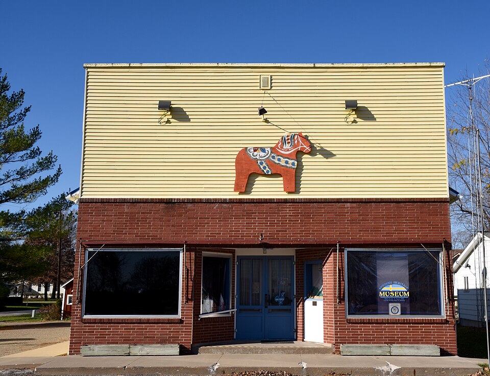
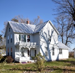
Photograph of Swedesburg Historic Commercial District
Photograph by Boscophotos, CC BY-SA 3.0. Via Wikimedia Commons.

Swedesburg Historic Commercial District

Listed on the National Register of Historic Places in 1999.

From the record

“The Swedesburg Historic Commercial District, also known as the Swedish Heritage Museum, is a nationally recognized historic district in Swedesburg, Iowa, United States. It was listed on the National Register of Historic Places in 1999.”

Wikipedia article Swedesburg Historic Commercial District, CC BY-SA 4.0.

One of 54 National Register listings published here for Henry County · listed in 1999 · category: District.

Sources: the Wikipedia article · the case file at the National Archives · the National Register database, National Park Service
The listing

  • What is counted as historic. The nomination lists 3 buildingss as contributing to the listing.
  • Address. 107 IA 218, Swedesburg, 52652
  • When was it listed? July 1999
  • Category. district
  • Also known as. Henry County, Iowa MPS
  • Township. Wayne township
  • National Register reference number. 99000829 - the number the National Park Service assigned this property when it was listed, and the key its nomination file is catalogued under at the National Archives.

Storms near this property

9 since 1994

Regional context, not property-specific evidence. The National Weather Service names Swedesburg, the town this property stands in, in 9 storm reports between 1994 and 2026: 4 hail, 3 thunderstorm wind, 1 flash flood, 1 tornado. No death or injury is recorded in these reports. Each account below is quoted exactly as the forecast office filed it, from the NOAA Storm Events Database, and each date opens the federal record of that event.

WhenEvent Place namedHarm What the report says
April 1994HailSwedesburg$5,000no account filed
August 2007Thunderstorm WindSwedesburg$100Winds estimated to be 60 mph blew away two stop signs near the intersection of 170th Street and Highway 218 about 7 miles north of Mount Pleasant.
July 2021HailSwedesburg-Golf ball hail on 218 near Swedesburg. Heavy rain with near zero visibility.
May 2020Thunderstorm WindSwedesburg-Several large tree limbs blown down.
May 2018HailSwedesburg-A public report was received of hail up to the size of nickels that last for 5 minutes.
July 2015Tornado (EF0)Swedesburg-An EF0 tornado with maximum winds estimated at 80 mph touched down 1.9 miles southwest of Swedesburg, IA. It traveled 1.51 miles and lifted 0.8 miles south of Swedesburg. The average path width was 10 yards. No damage was reported.
June 2007Flash FloodSwedesburg-A portion of a gravel road (Kentucky Ave) south of Highway 78 washed away in the heavy rains. Time estimated.
March 2026HailSwedesburg-no account filed
April 2026Thunderstorm WindSwedesburg-no account filed

Every storm recorded in Henry County

Map coverage status

No historic map-sheet match is published for this property yet. That does not mean no map exists. This record needs a coordinate-quality review before it can be joined to a sheet boundary. Browse the county's mapped places while that work is pending.

Listed places nearby

6 within 8 miles

Other National Register properties close enough to walk or drive between, ordered by distance from this one. Both positions come from the same geocoding pass that matched these properties to their map sheets.

Photograph PropertyDistance Listed
Red Ball Garageunder 500 feet1999
Hult, Charles E., House, Summer Kitchen and Wood Shedunder 500 feet1999
Swedish Evangelical Lutheran Churchunder 500 feet1999
John Hultquist House0.1 miles1999
Samuel and Sarah Hulme House5.3 miles2019
Benjamin Chapel and Richwoods Cemetery6.4 miles2015

Sources for this property

National Archives recordThe nomination case file for reference 99000829 in Record Group 79.
Wikipedia articleCommunity-written account of this property, licensed CC BY-SA.
Henry CountyAll 54 listed properties in this county.

Provenance

  • Listing record. National Park Service National Register of Historic Places, listed-properties dataset, current to 2026-05-22.
  • Map join. Address geocoded through the United States Census geocoder, then tested against the published boundary of every sheet in the USGS Historical Topographic Map Collection.
  • How this page is made. Listing fields come from federal records; map-sheet coverage is a labelled coordinate-to-boundary calculation, not a source-field claim.
  • Storms. NOAA National Centers for Environmental Information, Storm Events Database https://www.ncei.noaa.gov/stormevents/ A work of the United States government, no copyright under 17 U.S.C. 105. Narratives are quoted verbatim from the National Weather Service report and are not edited or summarised.