 Block
From the record
7 National Register listings published here.
Sources: the National Register database, National Park Service
66 topographic sheets cover 27 settlements here, and 7 properties are on the National Register of Historic Places.
7 National Register listings published here.
Sources: the National Register database, National Park Service
Every property in this county listed on the National Register of Historic Places, with the year it was listed and the federal nomination document.
| Photograph | Property | Type | Listed | Reference |
|---|---|---|---|---|
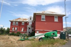 | Adams County Courthouse | building | 1987 | 87001599 |
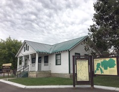 | Council Ranger Station | building | 1992 | 92000689 |
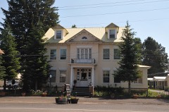 | Col. E. M. Heigho House | building | 1978 | 78001041 |
| A. O. Huntley Barn | building | 1978 | 78001040 | |
| Indian Mountain Fire Lookout | building | 2022 | 100007977 | |
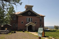 | Meadows Schoolhouse | building | 1979 | 79000769 |
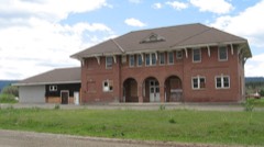 | Pacific and Idaho Northern Railroad Depot | building | 1978 | 78001042 |
Every wildfire the federal occurrence database records inside this county: 1,140 of them, burning about 118,259 acres. 821 started naturally and 28 were recorded as arson. Each settlement page carries the fires within five miles of it.
| Reported cause | Fires |
|---|---|
| Natural | 821 |
| Recreation and ceremony | 131 |
| Missing data/not specified/undetermined | 65 |
| Debris and open burning | 45 |
| Equipment and vehicle use | 29 |
| Arson/incendiarism | 28 |
| Smoking | 10 |
| Power generation/transmission/distribution | 6 |
| Misuse of fire by a minor | 2 |
| Fireworks | 1 |
| Railroad operations and maintenance | 1 |
| Other causes | 1 |
The five largest, by the area the report gives. None of them was recorded as arson.
| Date | Cause | Size | Reported by | Name on the report |
|---|---|---|---|---|
| 26 July 2018 | Equipment and vehicle use | 34,729 acres | Payette National Forest | MESA |
| 30 August 2007 | Natural | 24,900 acres | Payette National Forest | GRAY'S CREEK |
| 19 August 1992 | Natural | 17,500 acres | Payette National Forest | WINDY RIDGE |
| 9 September 2012 | Natural | 16,010 acres | Payette National Forest | WESLEY |
| 14 August 1996 | Natural | 4,800 acres | Wallowa-Whitman National Forest | DAM |
| 4 August 2000 | Natural | 2,732 acres | Payette National Forest | GOODRICH |
| 21 August 2006 | Natural | 2,298 acres | Wallowa-Whitman National Forest | HORSE HEAVEN |
| 29 June 2015 | Natural | 2,056 acres | Boise District | SHIRTS |
Every settlement page carries the fires within five miles of it - see the settlement index below.
The NOAA Storm Events Database holds 35 reports for this county, causing no deaths, 2 injuries and about $580,500 in recorded property damage. Each settlement page carries the reports that name it.
| Kind of event | Reports |
|---|---|
| Thunderstorm Wind | 13 |
| Heavy Rain | 8 |
| Hail | 6 |
| Tornado | 3 |
| Flood | 3 |
| Flash Flood | 2 |
The most serious of them, by death, then injury, then recorded damage. The accounts are quoted exactly as the forecast office filed them.
| When | Event | Place named | Harm | What the report says |
|---|---|---|---|---|
| June 2006 | Tornado (F2) | Bear | 1 hurt, $100,000 | F2 Tornado started at 2 miles west of Bear and moved to 12 miles north east of Bear. Extensive forest damage but minimal structural damage to homes. 1 pickup truck destroyed. Trees down in camp site detroyed tents and camping gear. Injury to one individual with a broken collar bone. |
| August 1993 | Thunderstorm Wind | not stated | 1 hurt | no account filed |
| April 2019 | Flood | Starkey | $403,000 | The Adams County emergency manager reported flooding and flash flooding including debris flow throughout the county. |
| June 2010 | Thunderstorm Wind | Council | $50,000 | Adams County Emergency Manager reported the roof was blown off of a church in Council including roof damage to other homes in the area. Also, many large trees were down along a path into the northeast part of the county. |
| June 1958 | Tornado (F1) | not stated | $25,000 | no account filed |
| July 1992 | Tornado (F0) | not stated | $2,500 | no account filed |
| December 2025 | Thunderstorm Wind | Cuprum | - | A wind gust measured instantaneously at 76 mph at Snake River RAWS occurred as a line of thunderstorms moved west to east. |
| September 2024 | Heavy Rain | Glendale | - | The mesonet station SQFI1, 8.7 miles East of Glendale, measured heavy rain from thunderstorms. |
| September 2024 | Heavy Rain | Meadows | - | The mesonet station BRRI1, 9.3 miles North of McCall, measured heavy rain after thunderstorms moved through the area. |
| September 2024 | Heavy Rain | Tamarack | - | The mesonet station, WBRI1, 8.8 miles northwest of Tamarack, measured heavy rain from nearby thunderstorms. |
| November 2024 | Heavy Rain | New Meadows Arpt | - | The CoCoRaHS station ID-AM-3 2.1 miles north northwest of New Meadows measured 0.86 inches of rain. |
| November 2024 | Heavy Rain | Meadows | - | The mesonet station SFFI1 at Ski Hill RAWS measured 1.22 inches of rain. |
| November 2024 | Heavy Rain | Starkey | - | The mesonet station WEFI1 at Weiser River measured 0.96 inches of rain. |
| March 2023 | Heavy Rain | Starkey | - | The mesonet station WEFI1 near Weiser River, ID measured near 0.62 inches of rain. |
| August 2022 | Hail | Cuprum | - | Multiple reports of hail ranging from 1-1.5 inches were submitted on social media. |
| May 2020 | Thunderstorm Wind | New Meadows | - | Downed trees and power lines blocked old Highway 95 near Hot Springs Road. |
| May 2018 | Hail | New Meadows Arpt | - | A trained spotter reported golf ball sized hail just north of New Meadows along U.S. Highway 95. |
| June 2012 | Hail | Council | - | Local media reported 1.00 inch hail in and around Council. |
| March 2012 | Flood | New Meadows | - | Several roads in New Meadows were flooded with water 1 to 2 feet deep including Hubbard Road and Main Street. |
| October 2012 | Heavy Rain | Glendale | - | A long duration rain occured in the head waters of the Weiser River in Adams County with a trained spotter measuring 0.95 inches. |
| June 2010 | Flash Flood | Indian Vly | - | Culverts on Mill Creek were plugged with debris causing road flooding. |
| June 2010 | Flood | Council | - | Flooding occurred across portions of Highway 95 and a trained spotter near Glendale reported over 1.30 inches of rain during an 11 hour period and flooding into fields along the Weiser River. |
| May 2007 | Hail | Bear | - | Spotter 1 Mile Northeast of Bear Idaho Reported Penny Sized Hail. |
| June 2004 | Thunderstorm Wind | Meadows | - | Down burst winds from a severe thunderstorm blew down several 100 ft tall Pine trees one of which cut a single wide mobile home in half. |
| May 1998 | Hail | Council | - | A severe thunderstorm produced 3/4 inch hail at Council. |
| May 1997 | Hail | Council | - | A severe thunderstorm formed over the Central Mountains and produced 3/4 inch hail . |
| June 1997 | Thunderstorm Wind | Cascade | - | Winds from a severe thunderstorm blew down a 20 inch diameter tree. |
| July 2003 | Flash Flood | Cuprum | - | no account filed |
| September 1998 | Thunderstorm Wind | Council | - | no account filed |
| August 1989 | Thunderstorm Wind | not stated | - | no account filed |
| June 1987 | Thunderstorm Wind | not stated | - | no account filed |
| April 1987 | Thunderstorm Wind | not stated | - | no account filed |
| December 1987 | Thunderstorm Wind | not stated | - | no account filed |
| August 1982 | Thunderstorm Wind | not stated | - | no account filed |
| July 1975 | Thunderstorm Wind | not stated | - | no account filed |
The Survey's mineral resources record lists 171 workings inside this county. 4 still produce and 167 are closed or unrecorded. Each settlement page carries the workings within five miles of it.
| Commodity | Workings |
|---|---|
| Copper | 70 |
| Gold | 41 |
| Silver | 17 |
| Sand and Gravel, Construction | 11 |
| Gold, Silver | 10 |
| Silver, Gold | 8 |
| Copper, Silver | 7 |
| Silver, Copper | 6 |
| Stone | 6 |
| Zinc | 5 |
| Manganese | 4 |
| Geothermal | 4 |
| Mica | 3 |
| Molybdenum, Tungsten | 3 |
The least common of them first, because a county's hundredth gravel pit says nothing its first ten did not.
| Where | Site | Commodity | Status | Recorded |
|---|---|---|---|---|
| Alaska Mine | Tungsten, Copper, Molybdenum | Past Producer | 1892, 1952 | |
| Arkansas Mine | Copper, Lead, Gold, Silver | Past Producer | 1887 | |
| Axe | Copper, Silver, Lead, Gold, Zinc | Past Producer | ||
| Azurite Mine | Copper, Lead, Zinc, Antimony, Gold, Silver | Past Producer | Vein | |
| Bald Eagle Mine | Gold, Copper, Silver, Zinc | Past Producer | Vein | |
| Bear Creek | Stone, Crushed/Broken | Past Producer | ||
| Blue Jacket Mine | Copper, Gold, Silver, Lead, Tungsten | Past Producer | 1887, 1897 | |
| Brundage | PGE | Occurrence | ||
| California Prospect | Copper, Garnet, Calcium, Stone, Crushed/Broken, Limestone, Dimension | Prospect | Contact Metamorphic | |
| Calumet Prospect | Copper, Gold, Silver, Tungsten | Past Producer | Contact Metamorphic | |
| Chieftain Claim | Gold, Silver, Molybdenum, Copper | Prospect | ||
| Corrieg & Telluride | Silver, Selenium | Occurrence | ||
| Frenchy's Mine | Copper, Gold, Molybdenum, Silver | Past Producer | 1880 | |
| Helena Mine | Gold, Silver, Copper, Molybdenum, Tungsten | Past Producer | 1887 | |
| Holbrook | Silver, Gold, Tellurium | Prospect | ||
| Inca Mine | Copper, Silver, Gold, Zinc | Prospect | ||
| Inspiration Barite Deposit | Barium-Barite | Prospect | 1944 | |
| Kearns | Silver, Selenium, Gold | Occurrence | ||
| Lime Peak Group | Gold, Copper, Silver | Occurrence | ||
| Lockwood Mine | Copper, Silver, Tungsten, Molybdenum | Past Producer | 1890 | |
| McCarty Prospect | Zinc, Copper, Gold, Silver, Lead | Past Producer | Vein | |
| Mica Queen Mine | Mica, Feldspar | Past Producer | 1906 | |
| North Hornet Mine | Gold, Uranium, REE, Niobium (Columbium), Sand and Gravel, Construction, Tantalum | Past Producer | 1931 | |
| Olympic & Allen | Copper, Tungsten, Silver, Gold, Zinc | Occurrence | ||
| Pepperbox | Copper, Molybdenum, Gold, Silver | Prospect | ||
| Pine Hill Prospect | Copper, Silver, Zinc | Prospect | ||
| Placer Basin Mine | Gold, Copper, Lead, Silver | Past Producer | Vein | |
| Rebound | Copper, Lead, Gold, Zinc, Silver | Occurrence | ||
| Red Ledge Mine | Silver, Copper, Zinc, Gold, Lead | Producer | 1895 | |
| Ritchie Gulch Adit | Gold, Lead, Silver | Prospect | ||
| Rock Flat Placer | Gold, Corundum, Gemstone, REE, Garnet, Zirconium, Titanium | Past Producer | Chromite, Corundum, Garnet, Gold, Ilmenite, Magnetite, Monazite, Platinum, Zircon | |
| Rose Marie Prospect | Chromium | Prospect | Chromite | |
| Stites Prospect | Feldspar, Mica | Prospect | Feldspar, Muscovite | |
| Thomas Heady Prospect | Copper, Lead, Zinc | Prospect | 1895 | |
| Thorn Creek Placers | Zirconium, REE | Prospect | ||
| Vick Creek Asbestos | Asbestos | Occurrence | ||
| Victory Tungsten | Tungsten, Copper, Antimony, Molybdenum | Prospect | ||
| Virginus Claim | Gold, Lead, Copper | Prospect | ||
| Ants Creek Prospect | Copper, Zinc, Silver | Past Producer | Malachite, Sphalerite, Tetrahedrite | |
| Copper Belt Mine | Copper, Lead | Past Producer | 1905 | |
| Curren Mountain Prospect | Gold, Zinc, Silver | Prospect | ||
| Diatomite Occurrence | Diatomite | Occurrence | Sedimentary | |
| Galena Mine | Lead | Occurrence | ||
| Hornet Creek Prospect | Silver, Gold, Copper | Occurrence | Chalcopyrite | |
| Humboldt Prospect | Copper, Gold | Prospect | Contact Metamorphic | |
| Indian Valley | Diatomite | Occurrence | ||
| McGrath Prospect | Iron, Tungsten | Occurrence | ||
| Peacock Mine | Copper, Gold, Silver, Zinc, Lead | Past Producer | 1877, 1888 | |
| Red Iron | Iron, Silver, Gold, Copper | Occurrence | ||
| Seven Devils District | Tungsten, Copper | Occurrence | SKARN | |
| Tungmarie Nos 2 and 5 | Zinc, Lead | Occurrence | ||
| Unknown | Copper, Gold | Prospect | ||
| Clark Mica Prospect | Mica | Prospect | ||
| Clark Prospect | Mica | Prospect | 1940 | |
| Patton Prospect | Molybdenum, Tungsten | Occurrence | Molybdenite, Scheelite | |
| Queen Mine | Copper, Silver, Gold, Tungsten | Past Producer | 1887, 1897 | |
| Switchback | Aggregate, Light Weight | Past Producer | ||
| Tussel Mine | Copper, Gold, Silver, Molybdenum, Tungsten | Past Producer | Bornite, Malachite | |
| West Branch | Aggregate, Light Weight | Past Producer | ||
| Yantis Ditch | Aggregate, Light Weight | Past Producer | ||
| Black Jack Nos. 1 & 2. | Manganese | Occurrence | ||
| Burnt Rock Prospect | Manganese | Past Producer | Vein | |
| Krigbaum Hot Springs | Geothermal | Occurrence | ||
| Manganese Mts. | Manganese | Unknown | ||
| New Meadows Manganese Deposit | Manganese | Occurrence | ||
| Starkey Hot Springs | Geothermal | Occurrence | ||
| White Licks Hot Springs | Geothermal | Occurrence | ||
| Zims Resort Hot Springs | Geothermal | Occurrence | ||
| Eckels Creek Stock Occurrence | Copper, Zinc | Occurrence | Bornite, Chalcocite, Chalcopyrite, Sphalerite | |
| Mann Creek Occurrence | Copper, Zinc | Occurrence | Bornite, Chalcocite, Chalcopyrite, Chrysocolla, Malachite, Sphalerite | |
| Wilford Prospect | Copper, Zinc | Prospect | Bornite, Chalcocite, Chalcopyrite, Chrysocolla, Malachite, Sphalerite | |
| Devil's Hollow Prospect | Gold, Silver, Copper | Prospect | ||
| Lost Lake Mine | Stone | Producer | ||
| Monument Peak Prospect | Gold, Silver, Copper | Prospect | ||
| New Meadows State Pit | Stone | Producer | ||
| Pactolian Gulch Prospect | Gold, Silver, Copper | Prospect | ||
| Quarry | Stone | Past Producer | ||
| Quarry | Stone | Past Producer | ||
| Satan Lake Prospect | Gold, Silver, Copper | Prospect | ||
| Unknown | Stone | Past Producer | ||
| Unknown | Stone | Past Producer | ||
| White Rose | Gold, Silver, Copper | Occurrence | ||
| Cliff Prospect | Gold, Copper, Silver | Prospect | Bornite, Chalcocite, Chalcopyrite, Covellite | |
| Crackerjack | Gold, Copper, Silver | Past Producer | ||
| Crescent | Gold, Copper, Silver | Occurrence | ||
| East Allison Gulch | Gold, Copper, Silver | Prospect | ||
| Emily Group | Gold, Copper, Silver | Prospect | ||
| Holbrook Saddle Prospect | Gold, Copper, Silver | Prospect | ||
| North Lime Creek | Gold, Copper, Silver | Past Producer | ||
| Badger Mine | Copper, Silver, Gold | Past Producer | Bornite, Chalcocite, Tetrahedrite | |
| Golden Star Claim | Copper, Silver, Gold | Prospect | ||
| Hibble Gulch Prospect | Copper, Silver, Gold | Prospect | ||
| Panama Pacific Claims Prospect | Copper, Silver, Gold | Prospect | 1890 | |
| River Queen Mine | Copper, Silver, Gold | Past Producer | 1912 | |
| Russell Mine | Copper, Silver, Gold | Past Producer | ||
| White Monument Mine | Copper, Silver, Gold | Past Producer | 1886, 1898 | |
| 1905 Mine | Copper, Gold, Silver | Past Producer | Bornite, Chalcocite, Cuprite, Malachite, Tetrahedrite | |
| Allison Creek Occurrence | Copper, Gold, Silver | Prospect | Chalcocite, Malachite | |
| Dry Gulch Prospect | Copper, Gold, Silver | Prospect | ||
| Jackley Ridge | Copper, Gold, Silver | Prospect | ||
| Lime Peak Prospect | Copper, Gold, Silver | Past Producer | Vein | |
| Lower Devil's Hollow Prospect | Copper, Gold, Silver | Prospect | ||
| Lynes Saddle | Copper, Gold, Silver | Prospect | ||
| Unknown | Copper, Gold, Silver | Occurrence | ||
| Campbell | Sand and Gravel, Construction | Producer | ||
| Gravel Pit | Sand and Gravel, Construction | Past Producer | ||
| Gravel Pit | Sand and Gravel, Construction | Past Producer | ||
| Gravel Pit | Sand and Gravel, Construction | Past Producer | ||
| Gravel Pit | Sand and Gravel, Construction | Past Producer | ||
| Gravel Pit | Sand and Gravel, Construction | Past Producer | ||
| Gravel Pit | Sand and Gravel, Construction | Past Producer | ||
| Gravel Pit | Sand and Gravel, Construction | Past Producer | ||
| Gravel Pit | Sand and Gravel, Construction | Past Producer | ||
| Gravel Pit | Sand and Gravel, Construction | Past Producer | ||
| Gravel Pit | Sand and Gravel, Construction | Past Producer | ||
| Bear Creek | Silver | Prospect | ||
| Black Lake Mine | Gold, Silver | Past Producer | 1893, 1905 | |
| Black Leopard Discovery Mine | Gold, Silver | Occurrence | ||
| Copper Cliff Mine | Copper, Silver, Gold | Past Producer | 1972 | |
| Eureka Group | Copper, Silver | Prospect | ||
| Idaho | Gold, Silver | Occurrence | ||
| Jackley | Silver | Occurrence | ||
| Lucky Strike Prospect | Copper, Silver | Past Producer | Bornite, Chalcocite, Chalcopyrite, Chrysocolla, Covellite, Malachite | |
| Maid of Erin Mine | Gold, Silver | Past Producer | ||
| Mayflower Group | Gold, Silver | Prospect | ||
| Oregon | Silver | Occurrence | ||
| Pactolian Mining Co. | Silver | Occurrence | ||
| South Peacock Mine | Silver | Past Producer | ||
| Victory 1 & 2 | Silver, Copper | Prospect | ||
| Anderson Group | Gold | Occurrence | ||
| Carrick Diggings Placer Mine | Gold | Past Producer | Placer | |
| Crane Creek | Gold | Occurrence | ||
| Great Eastern | Gold | Occurrence | Quartz | |
| H.B. Smith Property | Gold | Prospect | ||
| Iron Springs | Gold | Past Producer | ||
| North Star Butte | Gold | Prospect | ||
| Paducah | Gold | Prospect | ||
| Paradise Cabin | Gold | Past Producer | ||
| Red Boy and Lucky Star | Gold | Occurrence | ||
| Summit | Gold | Occurrence | ||
| Trail Creek | Copper, Gold | Prospect | ||
| Twin Lakes Prospect | Gold | Occurrence | ||
| Unknown | Gold | Occurrence | ||
| Unknown | Gold | Occurrence | ||
| A. J. Cole Property | Copper | Prospect | ||
| Anchor Creek | Copper | Prospect | ||
| Cable Line Occurrence Prospect | Copper | Prospect | Chalcocite, Malachite | |
| Chipman | Copper | Occurrence | ||
| Copper Occurrence | Copper | Occurrence | Bornite, Chalcocite, Chalcopyrite, Copper, Cuprite, Malachite | |
| Douglass Prospect | Copper | Prospect | Contact Metamorphic | |
| Glasgow-Green Prospect | Copper | Prospect | Contact Metamorphic | |
| Goodrich Creek Canyon Prospect | Copper | Occurrence | ||
| Granite Queen Property | Copper | Occurrence | Chalcocite, Chalcopyrite, Malachite | |
| Hathaway Gulch Occurrence | Copper | Unknown | ||
| Horse Mountain Occurrence | Copper | Occurrence | Bornite, Chalcocite, Malachite | |
| Legal Tender | Copper | Occurrence | ||
| Lucky Star Mine | Copper | Unknown | ||
| Lucky Strike Mine | Copper | Past Producer | ||
| Lynes Occurrence | Copper | Occurrence | Bornite, Chalcocite, Malachite | |
| O'Leary's Prospect | Copper | Prospect | Contact Metamorphic | |
| Peck Mtn. Copper Deposit | Copper | Prospect | ||
| Pot of Gold | Copper | Prospect | ||
| Red Wing Prospect | Copper | Prospect | Bornite, Chalcocite, Cuprite, Malachite, Tetrahedrite | |
| South Peacock Mine | Copper | Past Producer | 1897 | |
| Stevens Saddle Prospect | Copper | Prospect | ||
| Terry Group | Copper | Prospect | ||
| Transfer Point Occurrence | Copper | Occurrence | Bornite, Chalcocite, Chrysocolla, Malachite | |
| Tussel Adit | Copper | Occurrence | ||
| Unknown | Copper | Prospect | ||
| Unnamed Prospect | Copper | Prospect | ||
| Windy Ridge Occurrence | Copper | Occurrence | Bornite, Chalcocite, Malachite |
Named settlements recorded in the Geographic Names Information System, each with the topographic sheets covering it. Villages, hamlets and abandoned places alike. Each is shown with the nearest named watercourse or landform and the survey quadrangle it falls on.
Council census division · 83632 · On Grays Creek · Indian Valley quadrangle
13 sheets, 1911 to 1986
Council census division · 83612 · On Goodrich Creek · Goodrich quadrangle
11 sheets, 1955 to 2004
Council census division · Near Indian Mountain · Cold Spring Ridge quadrangle
14 sheets, 1911 to 2004
Council census division · 83612 · Near Grossen Canyon · Council quadrangle
14 sheets, 1911 to 2004
Council census division · 83612 · Near Hitchcock Gulch · Cuprum quadrangle
13 sheets, 1920 to 2004
Council census division · 83612 · Near Meridian Gulch · Tamarack quadrangle
13 sheets, 1911 to 1986
Council census division · 83612 · On West Fork Weiser River · Fruitvale quadrangle
14 sheets, 1911 to 2004
Council census division · 83612 · On Trail Creek · Fruitvale quadrangle
14 sheets, 1911 to 2004
Council census division · 83612 · On Goodrich Creek · Goodrich quadrangle
11 sheets, 1955 to 2004
Council census division · 83654 · On Copper Creek · White Monument quadrangle
12 sheets, 1920 to 1990
Council census division · 83632 · Near Indian Valley · Indian Valley quadrangle
13 sheets, 1911 to 1986
No longer a settlement
Council census division · 83612 · On Camp Creek · Fruitvale quadrangle
14 sheets, 1911 to 2004
Council census division · 83654 · On Placer Creek · Cuprum quadrangle
13 sheets, 1920 to 2004
New Meadows census division · 83654 · On Goose Creek · Meadows quadrangle
13 sheets, 1911 to 2004
New Meadows census division · 83654 · On Little Creek · New Meadows quadrangle
14 sheets, 1911 to 2004
New Meadows census division · 83612 · On Beaver Creek · Tamarack quadrangle
13 sheets, 1911 to 1986
New Meadows census division · 83654 · On Lockwood Creek · Pollock quadrangle
13 sheets, 1938 to 1995
Council census division · 83654 · On Mill Creek · He Devil quadrangle
16 sheets, 1922 to 1995
New Meadows census division · 83654 · On Little Mud Creek · New Meadows quadrangle
14 sheets, 1911 to 2004
Council census division · 83612 · On Warm Spring Creek · Fruitvale quadrangle
14 sheets, 1911 to 2004
New Meadows census division · 83612 · On East Fork Weiser River · Fruitvale quadrangle
14 sheets, 1911 to 2004
New Meadows census division · 83612 · Near Price Valley · Tamarack quadrangle
13 sheets, 1911 to 1986
Council census division · 83612 · On Beaver Creek · Tamarack quadrangle
13 sheets, 1911 to 1986
The vanished settlements of Adams County: the places named above that are no longer on the map.