 Block
From the record
8 National Register listings published here.
Sources: the National Register database, National Park Service
56 topographic sheets cover 35 settlements here, and 8 properties are on the National Register of Historic Places.
8 National Register listings published here.
Sources: the National Register database, National Park Service
Every property in this county listed on the National Register of Historic Places, with the year it was listed and the federal nomination document.
| Photograph | Property | Type | Listed | Reference |
|---|---|---|---|---|
 | Benewah County Courthouse | building | 1987 | 87001580 |
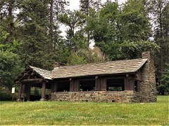 | Chatcolet CCC Picnic and Camping Area | building | 1995 | 94000632 |
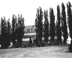 | Coeur d'Alene Mission of the Sacred Heart | building | 1975 | 75000623 |
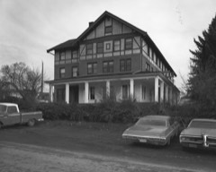 | Kootenai Inn | building | 1979 | 79000774 |
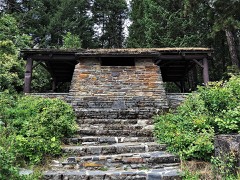 | Plummer Point CCC Picnic and Hiking Area | building | 1995 | 94001587 |
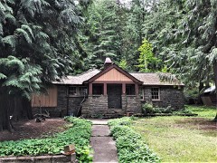 | Rocky Point CCC Properties | building | 1995 | 94001588 |
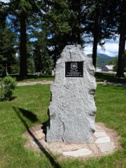 | St. Maries 1910 Fire Memorial | site | 1984 | 84001010 |
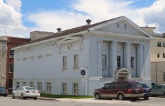 | St. Maries Masonic Temple No. 63 | building | 2011 | 11000699 |
Every wildfire the federal occurrence database records inside this county: 696 of them, burning about 3,846 acres. 246 started naturally and 28 were recorded as arson. Each settlement page carries the fires within five miles of it.
| Reported cause | Fires |
|---|---|
| Natural | 246 |
| Debris and open burning | 192 |
| Missing data/not specified/undetermined | 78 |
| Equipment and vehicle use | 61 |
| Recreation and ceremony | 39 |
| Arson/incendiarism | 28 |
| Fireworks | 16 |
| Misuse of fire by a minor | 16 |
| Smoking | 13 |
| Railroad operations and maintenance | 3 |
| Power generation/transmission/distribution | 3 |
| Firearms and explosives use | 1 |
The five largest, by the area the report gives. None of them was recorded as arson.
| Date | Cause | Size | Reported by | Name on the report |
|---|---|---|---|---|
| 3 August 2007 | Equipment and vehicle use | 505 acres | Idaho Department of Lands | ECHO SPRINGS |
| 27 August 2016 | Equipment and vehicle use | 440 acres | Idaho Department of Lands | JOHN DOE |
| 6 May 2019 | Debris and open burning | 305 acres | Idaho Department of Lands | PROSPECT |
| 27 October 2008 | Debris and open burning | 180 acres | Idaho Department of Lands | HELLS GULCH CANYON |
| 8 August 2008 | Natural | 132 acres | Idaho Department of Lands | HUME CREEK |
| 12 September 2002 | Missing data/not specified/undetermined | 122 acres | Idaho Department of Lands | LOTUS POINT FIRE |
| 22 August 1996 | Natural | 111 acres | Northern Idaho Agency | MOSES |
| 14 September 2005 | Debris and open burning | 100 acres | Northern Idaho Agency | 4 CORNERS |
Every settlement page carries the fires within five miles of it - see the settlement index below.
The NOAA Storm Events Database holds 50 reports for this county, causing no deaths, no injuries and about $2,404,250 in recorded property damage. Each settlement page carries the reports that name it.
| Kind of event | Reports |
|---|---|
| Flood | 18 |
| Thunderstorm Wind | 14 |
| Hail | 13 |
| Wildfire | 2 |
| Flash Flood | 1 |
| Heavy Rain | 1 |
| Debris Flow | 1 |
The most serious of them, by death, then injury, then recorded damage. The accounts are quoted exactly as the forecast office filed them.
| When | Event | Place named | Harm | What the report says |
|---|---|---|---|---|
| March 2017 | Flood | Plummer | $500,000 | Snow melt and periodic heavy rain during the month of March produced numerous debris flows and areal flooding issues across Benewah County. Numerous roads were damaged by flooding. Most notably debris flows and rock slides closed the road between Plummer and St. Maries, and flooding severely damaged State Highway 5 near Round Lake. Benewah County was included in an Idaho State State of Emergency Declaration as a result of this episode. |
| March 2014 | Flood | Tensed | $500,000 | A lot of field flooding and some road washouts in the area. Deep Creek came up and washed out a culvert and the road above it. Water also surrounded some homes along Deep Creek. Damage costs were estimated. |
| March 2017 | Flood | Ramsdell | $400,000 | The St. Joe River Gage at St. Maries recorded a rise above the Flood Stage of 32.5 feet at 6:15 AM PST on March 15th. The river continued to rise through the Moderate Flood Stage by March 16th and passed through the Major Flood Stage of 38.0 feet at 9:15 AM March 19th. The river crested at 10:45 PM on March 19th at 39.2 feet. The river receded to below Major Flood Stage at 11:30 PM March 24th and dropped through the Moderate Flood Stage by the morning of March 25th. The river remained in Minor Flood through the end of March and into April. |
| February 1999 | Flash Flood | Tensed | $250,000 | Heavy rain caused Hangman Creek to flood. |
| March 2017 | Flood | Desmet | $200,000 | The Palouse River Gage at Potlach, ID recorded a rise above the Flood Stage of 15.0 feet at 10:00 PM PST March 14th, cresting at 17.5 feet at 10:30 AM March 16th. The river dropped below Flood Stage during the evening of the 17th but then rose again above Flood Stage during the afternoon of the 19th cresting 15.6 feet before receding below Flood Stage for the end of the event during the evening of March 19th. |
| March 2012 | Flood | Chatcolet | $200,000 | There were numerous reports of water over roadways and washouts. Road closures included the south end of Sagle Road, Talache Road at Camp Stidwell, Blacktail Road near Little Blacktail Mountain Road, Cocolalla Loop Road near address 3900 and Sportsmans Access Road. Partial road washouts included Jewel Lake Road at mile marker 2.5, Schneider Road between mile marker 3 and 4, Nettleingham Road, Snow Valley Road, Petterson Road and Boyer Road near Vedelwood Road. |
| April 2017 | Flood | Ramsdell | $100,000 | The USGS St. Joe River Gage at St. Maries recorded a Minor Flood on the St. Joe River during the first week of April. The river receded to below the Flood Stage of 32.5 feet at 6:15 AM PST on April 5th and continued to fall through the rest of the month. |
| July 1998 | Thunderstorm Wind | St Maries | $50,000 | numerous trees down along St. Joe River. tree down on pickup truck. high winds forced car off the road into a sewer pond. |
| May 2008 | Flood | St Maries | $50,000 | no account filed |
| August 1998 | Wildfire | St Joe | $25,000 | Lightning sparked 25 small fires near St. Joe, each ranging 1-5 acres in size. |
| March 2012 | Flood | St Maries | $23,000 | The Ridgeview Apartments located in Saint Maries had to be evacuated when Mutch Creek flooded its banks and began to seep into the building. |
| April 2012 | Flood | St Maries Muni Arpt | $20,000 | Flood waters from the St. Joe River at St. Maries covered Lagoon Road and inundated some residential properties in this area. Some damage was observed to the levees. There was a rotational failure on the riverward side and slippage in a part of the one of the levees. Damage reported was estimated. |
| July 1998 | Wildfire | St Maries | $20,000 | a 2 acre wildfire threatened St. Maries High School. |
| January 2011 | Flood | Ferrell | $15,000 | Significant flooding reported along the St. Joe River Road from St. Maries to Avery in Shoshone County as the St. Joe River spilled over its banks. The road to St. Joe City was completely under water and flooding reported five miles up St. Maries River Road at Kittle Loop. The St. Joe River at St. Maries went above its flood stage of 32.5 feet at 1023PST on the 17th; crested at 35.97 feet at 905PST on the 18th; and then went back below flood stage at 500PST on the 20th. |
| December 2011 | Thunderstorm Wind | St Maries | $10,750 | The St Maries COOP reported a tree had fallen onto power-lines in the Benewah Valley due to strong wind gusts associated with thunderstorms between 1230 AM PST and 100AM PST. |
| August 2014 | Thunderstorm Wind | Sanders | $10,000 | A section of a wall and roof was blown off a tribal maintenance shop in Tensed. Several large branches were blown down near a wastewater plant one mile south of Tensed. In northern sections of the county, numerous branches three to four inches in diameter were blown down at the Saint Joe Landing Campground. |
| May 2018 | Flood | Ramsdell | $5,000 | The USGS River Gage on the St. Joe River at St. Maries recorded a rise above the Flood Stage of 32.5 feet at 2:15 PM PST on May 7th. The river crested at the Minor Flood level of 33.9 feet at 6:00 PM PST May 10th and remained at that level until beginning to recede on May 11th. The river receded below Flood Stage at 10:45 AM PST on May 19th. |
| February 2017 | Flood | St Maries Muni Arpt | $5,000 | An ice jam on the St. Joe River flooded portions of the St. Joe River Road making it impassable for travel upstream from the jam. Minor field flooding was reported downstream as the as the ice jam broke up and released the dammed water. |
| June 2016 | Thunderstorm Wind | Santa | $5,000 | A member of the public reported several 50 foot cottonwood trees blown over onto highway 3 between Fernwood and Emerald Creek along with dime sized hail not far from Santa, Idaho. |
| March 2014 | Thunderstorm Wind | St Maries | $5,000 | Tree toppled over onto power lines and across two lanes along Highway 5 near St. Maries. Damage costs estimated. |
| May 1997 | Thunderstorm Wind | St Maries | $5,000 | trees down by wind |
| April 2017 | Thunderstorm Wind | St Maries | $2,000 | Wind gusts from a thunderstorm resulted in roof and antenna damage to a business in St. Maries. |
| July 2014 | Hail | Sanders | $2,000 | A splitting supercell thunderstorm tracked southwest to northeast through Benewah county. The right mover produced hail ranging from a quarter to half dollar over southwestern reaches of the county. This included the community of Santa. The left moving cell produced nickel to quarter size hail across northwestern reaches of the county including Chatcolet Lake. |
| September 2024 | Debris Flow | Sanders | $1,000 | Public report via social media stated rocks on Highway 12 within the Gwen Fire burn scar. This was confirmed by dispatch. Rocks were cleared and highway remained open. Nearby gauges reported 0.40 of an inch to 0.80 of an inch of rain over the last 18 hours. |
| September 2024 | Thunderstorm Wind | Alder Creek | $500 | Multiple trees snapped and downed within the area. Time estimated by radar. |
| July 2019 | Thunderstorm Wind | Sanders | - | A weather spotter near Sanders reported multiple trees snapped and uprooted in nearby yards and wooded areas due to thunderstorm wind gusts. The trees were 12 to 20 inches in diameter. No structure damage beyond a downed power line was reported. |
| August 2019 | Thunderstorm Wind | St Maries | - | The Benewah County Sheriff reported two trees blown down by thunderstorm winds near St. Maries. Trees were blocking a road. |
| August 2019 | Hail | Plummer | - | Hail, with up to 1 inch diameter stones, covered the ground to a depth of 6 inches near Plummer. |
| December 2015 | Flood | Santa | - | A federal agency reported water out of bank near Santa, Idaho on the St Maries river and an ice jam. |
| February 2014 | Flood | Plummer | - | Several low lying areas experienced minor flooding. Sections of Lovell Valley Road near Plummer was covered in water in some sections. |
| August 2013 | Hail | Santa | - | A weather spotter in Fernwood reported hail one inch in diameter. Time was estimated based on radar. |
| April 2012 | Flood | Riverdale | - | The Saint Joe River at Saint Maries rose above the flood stage of 32.5 feet at 0300 PDT on March 31st, crested at 33.9 feet at 0600 PDT on April 1st, and receded below flood stage 2100 PDT on April 3rd. Saint Joe City Road flooded. Minor flooding was observed throughout low lying areas of the Saint Joe Valley and of the Aqua Park in Saint Maries. |
| June 2012 | Hail | Chatcolet | - | A severe thunderstorm developed northwest of the St. Joe National Forest. The thunderstorm intensified as it moved northeast between Heyburn State Park and St. Maries. The thunderstorm proceeded to head northward as a new updraft developed across Benewah County into Kootenai County. |
| March 2012 | Flood | Riverdale | - | The Saint Joe River at Saint Maries rose above the flood stage of 32.5 feet at 0300 PDT on March 31st, crested at 33.9 feet at 0600 PDT on April 1st, and receded below flood stage 2100 PDT on April 3rd. Saint Joe City Road flooded. Minor flooding was observed throughout low lying areas of the Saint Joe Valley and of the Aqua Park in Saint Maries. |
| July 2012 | Hail | Ramsdell | - | Hail sizes were generally between pea to dime but a few nickel to quarter size hailstones were observed. |
| April 2011 | Flood | Fernwood | - | The Coeur D Alene Press reported that the St Maries River flooded it banks at Fernwood covering a manhole in town, leaking wastewater into the river. There were no direct impacts to health or wildlife. |
| July 1998 | Hail | Santa | - | three quarter inch diameter hail |
| July 1998 | Hail | Emida | - | 1 inch diameter hail. |
| June 2012 | Hail | Plummer Jct | - | no account filed |
| July 2012 | Hail | Tensed | - | no account filed |
| June 2009 | Heavy Rain | Tensed | - | no account filed |
| June 2008 | Flood | St Maries | - | no account filed |
| June 2006 | Hail | Tensed | - | no account filed |
| May 2006 | Hail | St Maries | - | no account filed |
| July 2006 | Hail | St Maries | - | no account filed |
| July 2006 | Hail | Santa | - | no account filed |
| June 1992 | Thunderstorm Wind | not stated | - | no account filed |
| August 1989 | Thunderstorm Wind | not stated | - | no account filed |
| July 1975 | Thunderstorm Wind | not stated | - | no account filed |
| July 1964 | Thunderstorm Wind | not stated | - | no account filed |
The Survey's mineral resources record lists 76 workings inside this county. 12 still produce and 64 are closed or unrecorded. Each settlement page carries the workings within five miles of it.
| Commodity | Workings |
|---|---|
| Sand and Gravel, Construction | 18 |
| Iron | 10 |
| Stone, Crushed/Broken | 7 |
| Gold | 5 |
| Garnet | 5 |
| Stone | 5 |
| Copper | 4 |
| Kaolin | 4 |
| Lead | 3 |
| Uranium | 3 |
| Clay | 3 |
| Stone, Dimension | 3 |
| Zinc | 1 |
| Lead, Zinc | 1 |
The least common of them first, because a county's hundredth gravel pit says nothing its first ten did not.
| Where | Site | Commodity | Status | Recorded |
|---|---|---|---|---|
| Big Five Group Prospect | Copper, Zinc, Lead, Phosphorus-Phosphates | Prospect | Chalcopyrite, Galena, Malachite, Pyromorphite | |
| Butte Mining Company Prospect | Lead, Zinc | Prospect | Galena, Sphalerite | |
| Chatcolet Lake Clay Occurrence | Fire Clay (Refractory) | Occurrence | Clay | |
| Decann Manganese Prospect | Manganese | Occurrence | ||
| Emerald Creek Mill | Gemstone | Producer | ||
| Engle Mtn. | Silver, Lead, Gold, Copper | Unknown | ||
| Green Back Claim Group | Zinc, Silver, Lead | Prospect | ||
| Hired Girl Prospect | Copper, Lead, Zinc | Past Producer | Chalcopyrite | |
| Hyde Ranch | Aluminum | Occurrence | ||
| Monarch Prospect | Lead, Copper, Zinc | Prospect | Chalcopyrite, Galena, Sphalerite, Tetrahedrite | |
| Round Lake Peat Occurrence | Peat | Occurrence | Peat | |
| Silver Star Prospect | Gold, Lead, Zinc, Copper, Silver | Prospect | Chalcopyrite, Galena, Sphalerite | |
| St. Maries Clay Occurrence | Brick Clay | Occurrence | Clay | |
| Tyson Placer | Gold, Tellurium | Producer | Gold | |
| Benewah Clay Deposit | Clay | Prospect | Clay | |
| Benewah Clay Occurrence | Clay | Occurrence | ||
| Benewah Lake Clay Occurrence | Clay | Occurrence | Clay | |
| Ellis Pit | Stone, Dimension | Past Producer | ||
| Ifi Fernwood Pit | Stone, Dimension | Unknown | ||
| Lenty Uranium Prospect | Uranium | Occurrence | Vein | |
| Lenty Uranium Prospect | Uranium | Occurrence | Vein | |
| Mountain View Min. Co. Prospect | Lead | Occurrence | 1927 | |
| State Pit Bw 84 5 | Stone, Dimension | Unknown | ||
| Varney Prospect | Uranium | Occurrence | Vein | |
| Charlie Creek Prospects | Gold, Copper | Occurrence | ||
| St. Maries Clay Occurrence | Kaolin | Occurrence | ||
| St. Maries Clay Occurrence | Kaolin | Occurrence | ||
| Tensed Mine | Kaolin | Producer | ||
| Thorn Creek Hill Kaolinite Occurrence | Kaolin | Occurrence | ||
| Bw-1001 Pit | Stone | Producer | ||
| Carpenter Creek | Garnet | Producer | ||
| Dement Pit | Stone | Producer | ||
| Emerald Creek Garnet | Garnet | Prospect | ||
| Emerald Creek Placer | Garnet | Producer | Placer | |
| Fernwood Mill | Garnet | Past Producer | ||
| Fernwood Pit | Stone | Producer | ||
| Garnet Mine | Garnet | Producer | ||
| Mauro Pit | Stone | Producer | ||
| Quarry | Stone | Occurrence | ||
| Unnamed Location | Gold | Past Producer | ||
| White Elephant Mine | Gold | Past Producer | Vein | |
| Joseph Quarry | Stone, Crushed/Broken | Producer | ||
| Stone Quarry | Stone, Crushed/Broken | Unknown | ||
| Stone Quarry | Stone, Crushed/Broken | Unknown | ||
| Stone Quarry | Stone, Crushed/Broken | Unknown | ||
| Stone Quarry | Stone, Crushed/Broken | Unknown | ||
| Stone Quarry | Stone, Crushed/Broken | Unknown | ||
| Stone Quarry | Stone, Crushed/Broken | Unknown | ||
| Atkinson Prospect | Iron | Occurrence | ||
| Benewah Shoshone Deposit | Iron | Occurrence | ||
| Eklund | Iron | Occurrence | ||
| Greenback Prospect | Iron | Occurrence | ||
| Iron Prospect | Iron | Prospect | ||
| Lefors | Iron | Past Producer | ||
| Mccleary Butte | Iron | Past Producer | ||
| Patterson Prospect | Iron | Occurrence | ||
| Robert Hyde Prospect | Iron | Occurrence | Vein | |
| Tensed Prospect | Iron | Occurrence | ||
| Carmon Pit | Sand and Gravel, Construction | Producer | ||
| Gravel Pit | Sand and Gravel, Construction | Past Producer | ||
| Gravel Pit | Sand and Gravel, Construction | Past Producer | ||
| Gravel Pit | Sand and Gravel, Construction | Past Producer | ||
| Gravel Pit | Sand and Gravel, Construction | Past Producer | ||
| Gravel Pit | Sand and Gravel, Construction | Past Producer | ||
| Gravel Pit | Sand and Gravel, Construction | Past Producer | ||
| Gravel Pit | Sand and Gravel, Construction | Past Producer | ||
| Gravel Pit | Sand and Gravel, Construction | Past Producer | ||
| Gravel Pit | Sand and Gravel, Construction | Past Producer | ||
| Gravel Pit | Sand and Gravel, Construction | Past Producer | ||
| Gravel Pit | Sand and Gravel, Construction | Past Producer | ||
| Gravel Pit | Sand and Gravel, Construction | Past Producer | ||
| Gravel Pit | Sand and Gravel, Construction | Past Producer | ||
| Gravel Pit | Sand and Gravel, Construction | Past Producer | ||
| Michaels Pit | Sand and Gravel, Construction | Past Producer | ||
| Plummer Pit and Plant | Sand and Gravel, Construction | Past Producer | ||
| State Pit Pw 77-5 | Sand and Gravel, Construction | Past Producer |
Named settlements recorded in the Geographic Names Information System, each with the topographic sheets covering it. Villages, hamlets and abandoned places alike. Each is shown with the nearest named watercourse or landform and the survey quadrangle it falls on.
St. Maries census division · 83861 · On Alder Creek · Lindstrom Peak quadrangle
10 sheets, 1955 to 1995
St. Maries census division · 83861 · On Windfall Creek · Benewah quadrangle
9 sheets, 1955 to 1994
St. Maries census division · 83861 · On Flat Creek · Lindstrom Peak quadrangle
10 sheets, 1955 to 1995
St. Maries census division · 83861 · On Cherry Creek · Saint Maries quadrangle
10 sheets, 1955 to 1995
Plummer census division · 83851 · On Pedee Creek · Chatcolet quadrangle
9 sheets, 1955 to 1981
Tensed census division · 83824 · Near King Valley · Tensed quadrangle
8 sheets, 1955 to 1985
St. Maries census division · 83830 · On Finn Creek · Fernwood quadrangle
10 sheets, 1955 to 1995
St. Maries census division · 83861 · On Flat Creek · Santa quadrangle
9 sheets, 1955 to 1995
Plummer census division · 83851 · On Pedee Creek · Chatcolet quadrangle
9 sheets, 1955 to 1981
St. Maries census division · 83861 · On Carlin Creek · Lindstrom Peak quadrangle
10 sheets, 1955 to 1995
St. Maries census division · 83861 · On Soldier Creek · Santa quadrangle
9 sheets, 1955 to 1995
St. Maries census division · 83861 · On Saint Maries River · Saint Maries quadrangle
10 sheets, 1955 to 1995
St. Maries census division · 83861 · Near Saint Maries Peak · Saint Maries quadrangle
10 sheets, 1955 to 1995
St. Maries census division · 83861 · On South Fork Santa Creek · West Dennis quadrangle
11 sheets, 1955 to 1994
St. Maries census division · 83861 · On Street Creek · Saint Joe Baldy quadrangle
10 sheets, 1955 to 1995
St. Maries census division · 83861 · On Benewah Creek · Benewah Lake quadrangle
9 sheets, 1955 to 1981
Plummer census division · 83851 · On Pedee Creek · Chatcolet quadrangle
9 sheets, 1955 to 1981
St. Maries census division · 83861 · On Benewah Creek · Benewah Lake quadrangle
9 sheets, 1955 to 1981
St. Maries census division · 83866 · On Sheep Creek · Santa quadrangle
9 sheets, 1955 to 1995
St. Maries census division · 83861 · On Saint Maries River · Saint Maries quadrangle
10 sheets, 1955 to 1995
Plummer census division · 83851 · On Pedee Creek · Benewah Lake quadrangle
9 sheets, 1955 to 1981
St. Maries census division · 83861 · On John Creek · Lindstrom Peak quadrangle
10 sheets, 1955 to 1995
St. Maries census division · 83861 · On Bond Creek · Saint Joe quadrangle
10 sheets, 1955 to 1995
St. Maries census division · 83861 · On Saint Maries River · Saint Maries quadrangle
10 sheets, 1955 to 1995
Tensed census division · 83870 · On Indian Creek · Sanders quadrangle
10 sheets, 1955 to 1994
St. Maries census division · 83866 · On Renfro Creek · Santa quadrangle
9 sheets, 1955 to 1995
St. Maries census division · 83861 · Benewah Lake quadrangle
9 sheets, 1955 to 1981
St. Maries census division · 83830 · On Wilson Creek · Santa quadrangle
9 sheets, 1955 to 1995
St. Maries census division · 83866 · On Dago Creek · Santa quadrangle
9 sheets, 1955 to 1995
Plummer census division · 83851 · On Moctileme Creek · Tekoa quadrangle
11 sheets, 1903 to 1984