 Block
From the record
4 National Register listings published here, 1 of them a National Historic Landmark.
Sources: the National Register database, National Park Service
36 topographic sheets cover 14 settlements here, and 4 properties are on the National Register of Historic Places.
4 National Register listings published here, 1 of them a National Historic Landmark.
Sources: the National Register database, National Park Service
Every property in this county listed on the National Register of Historic Places, with the year it was listed and the federal nomination document.
| Photograph | Property | Type | Listed | Reference |
|---|---|---|---|---|
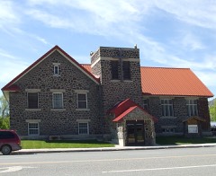 | Arco Baptist Community Church | building | 2001 | 01001303 |
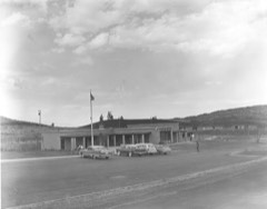 | Craters of the Moon National Monument Mission 66 Historic District | district | 2022 | 100006698 |
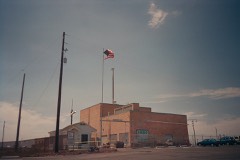 | Experimental Breeder Reactor No. 1 | building | 1966 | 66000307 |
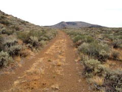 | Goodale's Cutoff | site | 1974 | 74000735 |
Every wildfire the federal occurrence database records inside this county: 215 of them, burning about 225,748 acres. 116 started naturally and none was recorded as arson. Each settlement page carries the fires within five miles of it.
| Reported cause | Fires |
|---|---|
| Natural | 116 |
| Fireworks | 30 |
| Missing data/not specified/undetermined | 26 |
| Equipment and vehicle use | 19 |
| Recreation and ceremony | 11 |
| Debris and open burning | 6 |
| Power generation/transmission/distribution | 2 |
| Other causes | 2 |
| Smoking | 2 |
| Firearms and explosives use | 1 |
The five largest, by the area the report gives. None of them was recorded as arson.
| Date | Cause | Size | Reported by | Name on the report |
|---|---|---|---|---|
| 13 July 2010 | Missing data/not specified/undetermined | 108,855 acres | Idaho Falls District | JEFFERSON |
| 25 August 2011 | Missing data/not specified/undetermined | 50,176 acres | Idaho National Laboratory | T17 |
| 1 July 1994 | Equipment and vehicle use | 21,433 acres | Idaho Falls District | BUTTE CITY |
| 27 July 2000 | Natural | 18,140 acres | Idaho Falls District | TIN CUP |
| 2 July 2020 | Recreation and ceremony | 6,617 acres | Idaho Falls District | HOWE PEAK |
| 2 September 1995 | Natural | 4,291 acres | Idaho Falls District | CROSSROAD |
| 31 August 2011 | Natural | 2,990 acres | Salmon-Challis National Forest | BLACK CANYON |
| 4 August 1992 | Missing data/not specified/undetermined | 2,272 acres | Idaho Falls District | CHANPAGNE |
Every settlement page carries the fires within five miles of it - see the settlement index below.
The NOAA Storm Events Database holds 255 reports for this county, causing no deaths, no injuries and about $579,030 in recorded property damage. Each settlement page carries the reports that name it.
| Kind of event | Reports |
|---|---|
| Thunderstorm Wind | 201 |
| Hail | 26 |
| Tornado | 8 |
| Flood | 8 |
| Funnel Cloud | 4 |
| Flash Flood | 3 |
| Wildfire | 3 |
| Heavy Rain | 1 |
| Lightning | 1 |
The most serious of them, by death, then injury, then recorded damage. The accounts are quoted exactly as the forecast office filed them.
| When | Event | Place named | Harm | What the report says |
|---|---|---|---|---|
| February 2017 | Flood | Moore | $265,000 | Extensive snowmelt occurred at low elevations as a warmup took place for a good portion of the first 2 to 3 weeks of the month. Extensive sheet flooding of fields occurred as well as extensive minor flooding of roadways and extreme damage of roadways due to the extreme snowfall and cold temperatures in December and January. |
| March 2017 | Flood | Moore | $135,000 | Sheet flooding continued throughout March in the county with continued road and minor property damages continuing. |
| March 2018 | Flood | Howe | $75,000 | Extensive sheet flooding caused extensive damage to county roads. |
| May 2017 | Flood | Moore | $45,000 | Field flooding damaging agriculture and the flooding continued to damage back roads with some minor basement flooding continued through the month. |
| July 1998 | Flash Flood | Arco | $20,000 | BLM reported road washed out on Big Southern Butte by 1 to 2 inches of rain from a thunderstorm. BLM estimated the storm caused a 50 year flood on the butte. |
| June 2017 | Flood | Moore | $10,000 | Field flooding damaging agriculture continued and also the flooding continued to damage back roads early in the month. |
| June 2025 | Lightning | Arco | $7,000 | A telephone pole was hit by lightning and caught on fire. |
| April 2009 | Thunderstorm Wind | Arco | $4,000 | The Arco mesonet site measured 63 mph wind gusts from a thunderstorms. Several trees were blown over in the city of Arco and the wind destroyed a large plate glass window in a flower shop. |
| July 2024 | Thunderstorm Wind | Arco | $3,000 | Power lines were downed off of Highway Drive in the areas of US 20 which caused a fire and several power outages. |
| May 2019 | Thunderstorm Wind | Darlington | $3,000 | Five to 6 power poles were snapped down 1 mile south of Darlington due to strong thunderstorm winds. The poles were snapped off just above the ground. It occurred near the mouth of Antelope Springs. |
| June 2018 | Tornado (EF0) | Darlington | $3,000 | A damage assessment team from the Pocatello National Weather Service Forecast Office traveled to Darlington, Idaho on June 22, 2018. The tornado was believed to have touched down around 1:15pm MDT on June 21, 2018, approximately 5 miles northwest of Darlington, Idaho. The assessment team found several large hardwood tree limbs down along Huston Road. The largest diameter limb was 1 foot in diameter. About 1.5 miles down Huston Road from Highway 93, a residence on the south side of the road experienced extensive tree damage as well, including a hardwood tree split near the trunk. A second tree was completely uprooted although the root system appeared to be somewhat shallow, perhaps only a couple of feet deep. A third tree was nearly uprooted. A camper was overturned and a large section of the metal roofing had been peeled back. Some of the trusses off of a garage with a metal roof were ripped off. Video of the tornado showed it traveling to the north of Leslie Butte, although it is not clear if it was still on the ground at this point. ||A second video shows the tornado on the ground approximately 1 mile northeast of Darlington around 1:32pm. The video shows the tornado on the ground for at least 3 minutes while east of Darlington. The damage team found a 40 to 50 foot section of barbed wire fencing down along with several metal fencing posts bent over or ripped out of the ground about 1.5 miles east of Darlington. The tornado lifted around 1:38pm MDT. The National Weather Service received reports of wheel lines, a chicken coop, pig pen, a shed destroyed, and a screen door ripped off. However, the damage assessment team was unable to find this damage. ||Based on the damage, the final assessment for this tornado is a high-end EF0 with winds of 75 to 85 mph. The tornado is estimated to have been 250 feet wide, 7 miles long, and lasted up to 23 minutes. |
| May 1992 | Tornado (F1) | not stated | $2,500 | no account filed |
| July 1987 | Tornado (F1) | not stated | $2,500 | no account filed |
| August 2011 | Flash Flood | Arco | $2,000 | Heavy rains and small hail caused flooding in Arco. Roadways in town flooded with damage reported by law enforcement. Hail was up to 2 inches deep in some parts of town. The basement in the new court house in Arco was flooded as well. |
| June 2016 | Thunderstorm Wind | Arco | $1,000 | Sixty mile per hour winds moved through Butte County on the 30th with Arco recording 63 mph at 2:55 pm MDT. Several small limbs were torn off trees in the city. |
| August 2014 | Flash Flood | Arco | $1,000 | COOP Observer reported 1 to 2 inches of water flowing across Highway 93 in the city of Arco. Minor residential flooding occurred with some flooding at the hospital. A city bridge on Era street washed out and the street was closed and minor flooding occurred on Highway 33. |
| April 1954 | Tornado | not stated | $30 | no account filed |
| April 2026 | Thunderstorm Wind | Arco | - | A 60 mph thunderstorm outflow wind gust measured at Tom Cat Summit ITD mesonet site. |
| April 2026 | Thunderstorm Wind | Arco | - | A 59 mph thunderstorm outflow wind gust was measured at the Tom Cat Summit ITD mesonet site. |
| April 2026 | Thunderstorm Wind | Arco | - | The INL Puzzle site recorded a 61 mph thunderstorm outflow wind. |
| April 2026 | Thunderstorm Wind | Berenice | - | A 58 mph thunderstorm outflow wind gust was measured at the Junction 33/22 Summit ITD mesonet site. |
| April 2026 | Thunderstorm Wind | Howe | - | The Specific Manufacturing INL mesonet site recorded a 67 mph wind gust. |
| May 2025 | Thunderstorm Wind | Arco | - | The INL Critical Infrastructure mesonet site recorded a 59 mph wind gust. |
| May 2025 | Thunderstorm Wind | Arco | - | The INL Puzzle mesonet site on US highways 20 and 26 recorded a 70 mph wind gust. |
| May 2025 | Thunderstorm Wind | Howe | - | A 58 mph thunderstorm wind gust measured 8 miles northwest of Howe at the S-C Portable #3 RAWS mesonet. |
| May 2025 | Thunderstorm Wind | Arco Butte | - | The RWM INL Radioactive Waste Mgmt mesonet site recorded a 60 mph wind gust. |
| May 2025 | Thunderstorm Wind | Howe | - | Mesonet station BAS Base of Howe Peak recorded a 61 mph wind gust. |
| May 2025 | Thunderstorm Wind | Howe | - | Mesonet station SAN 12 recorded a 66 mph wind gust 12 miles east of Howe. |
| May 2025 | Thunderstorm Wind | Arco Butte | - | A 63 mph wind gust recorded at mesonet station DEA Dead Man Canyon. |
| May 2025 | Thunderstorm Wind | Howe | - | A 59 mph wind gust measured at LOF INL Specific Manufacturing site. |
| May 2025 | Thunderstorm Wind | Howe | - | A 63 mph wind gust recorded at NRF INL Naval Reactors Facility. |
| May 2025 | Thunderstorm Wind | Howe | - | A 66 mph wind gust recorded at LOF INL Specific Manufacturing site. |
| May 2025 | Thunderstorm Wind | Arco | - | A 58 mph wind gust was recorded at the Craters of the Moon mesonet site. |
| May 2025 | Thunderstorm Wind | Arco | - | Mesonet station 3699 D6 INL Puzzle recorded a 60 mph wind gust. |
| May 2025 | Thunderstorm Wind | Arco | - | A 64 mph wind gust was recorded at Big Southern Butte. |
| May 2025 | Thunderstorm Wind | Arco | - | A 62 mph wind gust was recorded at the INL Central Facilities mesonet station. |
| May 2025 | Thunderstorm Wind | Arco | - | A 61 mph wind gust recorded at Lost River Rest Area. |
| May 2025 | Thunderstorm Wind | Arco | - | A 68 mph wind gust recorded at mesonet station TRA INL Reactor Tech Complex. |
| May 2025 | Thunderstorm Wind | Arco | - | A 64 mph wind gust recorded at mesonet station GRI INL INTEC/Grid 3. |
| May 2025 | Thunderstorm Wind | Arco | - | A 59 mph wind gust recorded at INL Puzzle mesonet site. |
| May 2025 | Thunderstorm Wind | Arco | - | A 59 mph wind gust recorded at INL Central Facilities. |
| May 2025 | Thunderstorm Wind | Arco | - | A 59 mph wind gust measured at the Tom Cat Summit mesonet site. |
| May 2025 | Thunderstorm Wind | Arco | - | A 59 mph wind gust recorded at Craters of the Moon mesonet site. |
| May 2025 | Thunderstorm Wind | Howe | - | A 59 mph wind gust recorded at the Base of Howe Peak mesonet site. |
| May 2025 | Thunderstorm Wind | Darlington | - | Mesonet site TT636 S-C Portable No. 3 recorded a 62 mph wind gust. |
| May 2025 | Thunderstorm Wind | Arco | - | A 58 mph wind gust measured at the INL Central Facilities mesonet site. |
| May 2025 | Thunderstorm Wind | Arco | - | A 60 mph thunderstorm outflow wind measured 9 miles east of Butte City at the Dead Man Canyon mesonet site. |
| June 2025 | Thunderstorm Wind | Arco | - | Thunderstorm winds caused power outages in parts of Butte County. |
| August 2025 | Thunderstorm Wind | Howe | - | The INL Specific Manufacturing mesonet site recorded a 60 mph thunderstorm outflow wind gust. |
| July 2025 | Thunderstorm Wind | Arco | - | A 60 mph wind gust measured at INL Puzzle ITD site. |
| July 2025 | Thunderstorm Wind | Howe | - | A 58 mph thunderstorm outflow wind measured at the Howe Peak mesonet station. |
| July 2025 | Thunderstorm Wind | Berenice | - | Mesonet station ITDD03 Junction Summit recorded a 58 mph thunderstorm outflow wind. |
| July 2025 | Thunderstorm Wind | Arco | - | A 69 mph thunderstorm outflow wind gust was measured at the INL Puzzle mesonet site. |
| July 2025 | Thunderstorm Wind | Howe | - | The LOF INL Specific Manufacturing mesonet site measured a 61 mph thunderstorm outflow wind gust. |
| July 2025 | Thunderstorm Wind | Arco | - | The Big Coxs Well mesonet station recorded a 59 mph thunderstorm outflow wind. |
| May 2024 | Thunderstorm Wind | Arco | - | The ITD Tom Cat Summit mesonet site recorded an 80 mph wind gust. |
| July 2024 | Thunderstorm Wind | Arco | - | ITD 95 RWIS INL Puzzle measured 59 mph wind gust at intersection of US 20 and US 26. |
| July 2024 | Thunderstorm Wind | Howe | - | The Sand Dunes mesonet station measured a 58 mph wind gust. |
| July 2024 | Thunderstorm Wind | Berenice | - | INL Specific Manufacturing mesonet site recorded 59 mph wind gust. |
| July 2024 | Thunderstorm Wind | Arco | - | A 60 mph wind gust measured near Arco at the ARC mesonet site. |
The Survey's mineral resources record lists 125 workings inside this county. 3 still produce and 122 are closed or unrecorded. Each settlement page carries the workings within five miles of it.
| Commodity | Workings |
|---|---|
| Lead | 50 |
| Copper | 24 |
| Silver | 21 |
| Zinc | 14 |
| Zinc, Silver | 7 |
| Lead, Silver | 6 |
| Iron | 6 |
| Sand and Gravel, Construction | 6 |
| Silver, Lead | 5 |
| Gold | 5 |
| Tungsten | 4 |
| Manganese | 4 |
| Copper, Zinc | 3 |
| Silver, Zinc | 3 |
The least common of them first, because a county's hundredth gravel pit says nothing its first ten did not.
| Where | Site | Commodity | Status | Recorded |
|---|---|---|---|---|
| Ajax Mine | Lead, Copper, Silver | Past Producer | Galena | |
| Antimony Prospect | Antimony | Prospect | Cervantite, Stibiconite, Stibnite | |
| Arco | Limestone, General | Past Producer | ||
| Automatic Mine | Copper, Lead, Silver, Zinc | Past Producer | ||
| Badger Creek Borrow Site | Stone, Crushed/Broken | Past Producer | ||
| Badger Creek Mine | Lead, Silver, Copper, Gold, Zinc | Past Producer | 1885 | |
| Badger King Mine | Copper, Zinc, Silver, Lead | Prospect | ||
| Big Southern Butte | Molybdenum | Prospect | ||
| Bighorn Mine | Lead, Zinc, Silver, Gold | Past Producer | Galena, Smithsonite | |
| Dome District | Silver, Gold, Zinc, Lead, Copper | Producer | REPLACEMENT | |
| Elbow Quartz | Silica | Prospect | ||
| Fish Haven Dolomite | Magnesite | Prospect | ||
| Golden Chariot Mine | Gold, Manganese, Copper, Silver, Lead | Past Producer | Chalcopyrite, Covellite, Galena, Psilomelane, Sphalerite | |
| Hamilton District | Silver, Gold, Lead, Copper | Producer | REPLACEMENT | |
| Hornsilver Mine | Silver, Gold, Zinc, Lead, Copper, Antimony, Bismuth | Past Producer | 1883 | |
| Hub Group | Silver, Manganese, Gold, Zinc, Copper, Lead | Past Producer | Anglesite, Chalcopyrite, Galena, Polybasite, Proustite, Psilomelane, Rhodochrosite, Smithsonite, Sphalerite, Stephanite | |
| Last Chance Mine | Silver, Zinc, Lead, Copper, Bismuth, Gold | Past Producer | Cerargyrite, Chalcanthite, Chalcopyrite, Galena, Sphalerite, Tetrahedrite, Wurtzite | |
| Lead Belt Mine | Lead, Silver, Gold, Copper | Past Producer | 1890, 1908 | |
| Lucky Billy Prospect | Zinc, Silver, Lead, Copper | Prospect | ||
| Martin Property Mine | Silver, Gold, Copper, Lead, Zinc | Past Producer | 1922 | |
| May Queen Prospect | Lead, Zinc, Gold | Prospect | ||
| Middle Fork of Pass Creek Prospect | Stone | Prospect | ||
| Pandora Prospect | Lead, Copper, Gold, Silver | Past Producer | Vein | |
| Pioneer | Barium-Barite, Gold | Prospect | ||
| Protection Prospect | Lead, Copper, Silver, Zinc | Prospect | Galena | |
| Reliance Mine | Zinc, Lead, Silver, Bismuth, Copper | Past Producer | Vein | |
| Saint Louis Mine | Silver, Zinc, Lead, Bismuth | Prospect | ||
| Sentinel Mine | Lead, Zinc, Molybdenum | Past Producer | Galena, Smithsonite, Sphalerite, Wulfenite | |
| Silver King Prospect | Copper, Silver, Lead, Zinc | Occurrence | Vein | |
| South Creek No. 4 Prospect | Lead, Silver, Copper, Zinc | Prospect | ||
| St. Louis Mine | Silver, Zinc, Copper, Lead, Bismuth | Past Producer | Argentite, Chalcopyrite, Silver, Sphalerite, Tetrahedrite, Wurtzite | |
| Ui No. 6 & 7 Prospect | Copper, Silver, Gold | Prospect | ||
| Unnamed Jasperoid Occurrences | Gold, Silver, Zinc, Cadmium, Bismuth, Selenium, Thallium, Antimony, Tin, Molybdenum, Mercury, Platinum, Copper, Tellurium, Lead, Arsenic | Past Producer | REPLACEMENT | |
| Wilbert Mine | Lead, Silver, Gold, Copper, Zinc | Past Producer | 1882, 1906 | |
| Bar No. 2 Prospect | Lead, Silver, Copper | Prospect | ||
| Bighorn Canyon Prospect | Stone, Dimension | Prospect | ||
| Butte - Antelope Mine | Lead, Silver, Zinc, Copper | Past Producer | 1890 | |
| Edna Mine | Lead, Silver, Zinc, Copper | Past Producer | Argentite, Chalcopyrite, Galena, Sphalerite | |
| Ella Mine | Silver, Lead, Zinc, Copper, Gold | Past Producer | 1883 | |
| Geothermal Location | Geothermal | Occurrence | ||
| Geothermal Location | Geothermal | Occurrence | ||
| Great Western Mine | Silver, Lead, Copper, Gold | Past Producer | Anglesite | |
| Johnson Property | Silver, Zinc, Lead | Prospect | Galena, Smithsonite | |
| South Creek No. 147 Prospect | Copper, Lead, Zinc | Prospect | ||
| South Creek Nos. 71-75, 88-89 | Copper, Gold, Silver | Prospect | ||
| Triumph Prospect | Lead, Silver, Copper | Prospect | ||
| Vj Prospect | Stone, Dimension | Prospect | ||
| Bc No. 53 Extension Prospect | Zinc, Lead | Prospect | ||
| Copper Mountain No. 8 | Lead, Silver, Zinc | Prospect | ||
| Diamond Prospect | Silver, Lead, Copper, Zinc | Past Producer | Vein | |
| Jersey Belle Prospect | Lead, Copper, Zinc | Prospect | ||
| Little Pittsburgh Mine | Lead, Silver, Zinc | Past Producer | ||
| Lucky Strike Prospect | Iron, Zinc, Lead | Prospect | ||
| Rubie Prospect | Copper, Zinc, Lead | Prospect | ||
| Silver Bell Mine | Lead, Silver, Manganese, Copper, Zinc | Past Producer | 1928 | |
| Whitebird Deposit | Lead, Silver, Zinc | Past Producer | Galena | |
| Bell View Mine | Iron, Manganese | Past Producer | ||
| Independence | Tungsten | Prospect | ||
| Lava Creek District | Tungsten | Occurrence | SKARN, QUARTZ VEINS | |
| Markell Prospect | Manganese | Prospect | ||
| Sam and Tom Mine | Silver, Lead, Tungsten | Past Producer | Galena, Powellite | |
| Wolframite Mine | Tungsten | Past Producer | Huebnerite, Wolframite | |
| Champagne | Gold | Plant | 1989 | |
| Eightmile Canyon Placer Prospect | Gold | Occurrence | ||
| San Francisco Prospect | Copper, Silver, Lead | Prospect | ||
| South Creek No. 119 Prospect | Copper, Silver, Lead | Prospect | ||
| Copper Mountain Mine | Copper, Lead, Silver | Past Producer | 1900 | |
| Gravel Pit | Sand and Gravel, Construction | Past Producer | ||
| Gravel Pit | Sand and Gravel, Construction | Past Producer | ||
| Gravel Pit | Sand and Gravel, Construction | Past Producer | ||
| Gravel Pit | Sand and Gravel, Construction | Past Producer | ||
| Gravel Pit | Sand and Gravel, Construction | Past Producer | ||
| Gravel Pit | Sand and Gravel, Construction | Past Producer | ||
| Iron Cap Prospect | Iron | Prospect | ||
| Log Chain Prospect | Iron | Prospect | ||
| Oxide Lode Prospect | Iron | Prospect | Iron | |
| South Creek No. 121 Prospect | Copper, Lead, Silver | Prospect | ||
| Waymire Prospect | Zinc, Iron | Prospect | ||
| Bc No. 53 Prospect | Lead, Zinc, Silver | Prospect | ||
| Cleopatra Prospect | Lead, Zinc, Silver | Prospect | ||
| Fallert Springs Prospect | Copper, Zinc, Silver | Occurrence | ||
| La Riviere Perdu No. 6 and 7 | Lead, Zinc, Silver | Prospect | ||
| Last Chance Prospect | Lead, Zinc, Silver | Prospect | ||
| Lookout Mine | Lead, Zinc, Silver | Past Producer | ||
| Ore House No. 7 and 8 | Lead, Zinc, Silver | Prospect | ||
| Bc No. 51 Prospect | Lead, Zinc | Occurrence | ||
| Bc No. 65 Prospect | Lead, Zinc | Prospect | ||
| Camp Creek Prospect No. 4 | Zinc, Lead | Prospect | ||
| Little Cottonwood | Lead, Zinc | Prospect | ||
| Nipper | Lead, Zinc | Occurrence | ||
| Ore House No. 32b Prospect | Copper, Zinc | Prospect | ||
| Rainbow Prospect | Lead, Zinc | Prospect | ||
| Silver Tip Mine | Silver, Lead, Zinc | Past Producer | Chalcopyrite, Galena, Sphalerite, Tetrahedrite | |
| South Creek No. 61 | Lead, Zinc | Prospect | ||
| South Creek No. 78 Prospect | Copper, Zinc | Prospect | ||
| Sparrow Prospect | Lead, Zinc | Prospect | ||
| Westside Prospect | Zinc, Lead | Prospect | ||
| Windfall Prospect | Lead, Zinc | Prospect | ||
| Badger Creek Prospect | Copper, Silver | Past Producer | ||
| Black Back Prospect | Lead, Silver | Prospect | ||
| Copper King Group | Silver, Lead | Prospect | ||
| Hope Prospect | Lead, Silver | Prospect | ||
| La Riviere Perdu No. 28 Prospect | Lead, Silver | Prospect | ||
| Silver Haze | Silver | Occurrence | ||
| South Creek No. 16 | Copper, Silver | Prospect | ||
| South Creek No. 36 | Lead, Silver | Prospect | ||
| Uncle Ike Creek Prospect | Lead, Silver | Prospect | ||
| Unnamed Prospect | Silver | Prospect | ||
| Valley View Mine | Lead, Silver | Prospect | ||
| Williams Creek Prospect | Lead, Silver | Prospect | ||
| Bar No. 7 | Lead, Copper | Prospect | ||
| Minia Prospect | Copper | Prospect | ||
| North Star Prospect | Copper | Prospect | ||
| Pearl Prospect | Lead, Copper | Prospect | ||
| Red Bird Prospect | Copper, Lead | Occurrence | ||
| Red Ledge No. 3 | Copper | Prospect | ||
| Red Ledge No. 8 Extension Prospect | Copper | Prospect | ||
| South Creek No. 24 | Copper | Prospect | ||
| Camp Creek Prospect No. 1 | Lead | Prospect | ||
| Camp Creek Prospect No. 2 | Lead | Prospect | ||
| Camp Creek Prospect No. 3 | Lead | Prospect | ||
| Cedar Post Prospect | Lead | Prospect | ||
| Nellie Boyd Prospect | Lead | Prospect | ||
| South Creek No. 10 | Lead | Prospect | ||
| Whiterock Prospect | Lead | Prospect | Galena |
Named settlements recorded in the Geographic Names Information System, each with the topographic sheets covering it. Villages, hamlets and abandoned places alike. Each is shown with the nearest named watercourse or landform and the survey quadrangle it falls on.
Arco census division · 83255 · Near Stoddard Gulch · Miller Peak quadrangle
12 sheets, 1935 to 1991
No longer a settlement
Howe census division · 83244 · On Wet Creek · Bell Mountain quadrangle
11 sheets, 1955 to 1989
Arco census division · 83255 · On Antelope Creek · Darlington quadrangle
10 sheets, 1955 to 1988
Arco census division · 83255 · Near Poison Gulch · Champagne Creek quadrangle
12 sheets, 1935 to 1991
Arco census division · 83213 · On Lava Creek · Champagne Creek quadrangle
12 sheets, 1935 to 1991
Howe census division · 83244 · Little Lost River Sinks quadrangle
9 sheets, 1955 to 1980
No longer a settlement
The vanished settlements of Butte County: the places named above that are no longer on the map.