 Block
From the record
10 National Register listings published here.
Sources: the National Register database, National Park Service
39 topographic sheets cover 16 settlements here, and 10 properties are on the National Register of Historic Places.
10 National Register listings published here.
Sources: the National Register database, National Park Service
Every property in this county listed on the National Register of Historic Places, with the year it was listed and the federal nomination document.
| Photograph | Property | Type | Listed | Reference |
|---|---|---|---|---|
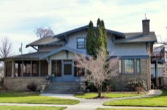 | F. T. Bliss House | building | 1982 | 82000345 |
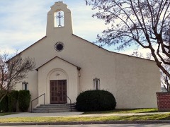 | Catholic Church of the Sacred Heart | building | 1980 | 80001323 |
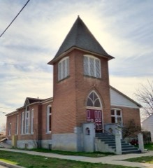 | Emmett Presbyterian Church | building | 1980 | 80001324 |
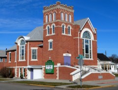 | First Baptist Church of Emmett | building | 1980 | 80001325 |
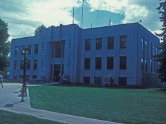 | Gem County Courthouse | building | 1982 | 82000347 |
| Methodist Episcopal Church | building | 1980 | 80001326 | |
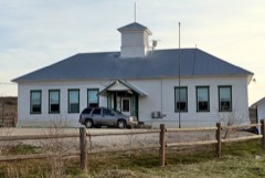 | Ola School | building | 1992 | 92000415 |
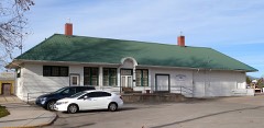 | Oregon Short Line Railway Depot | building | 1995 | 95000506 |
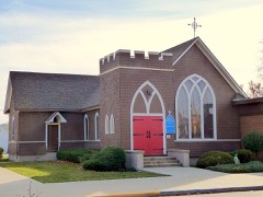 | St. Mary's Episcopal Church | building | 1980 | 80001327 |
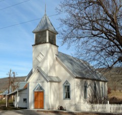 | Sweet Methodist Episcopal Church | building | 1997 | 97000766 |
Every wildfire the federal occurrence database records inside this county: 304 of them, burning about 110,527 acres. 155 started naturally and 11 were recorded as arson. Each settlement page carries the fires within five miles of it.
| Reported cause | Fires |
|---|---|
| Natural | 155 |
| Missing data/not specified/undetermined | 47 |
| Equipment and vehicle use | 26 |
| Recreation and ceremony | 17 |
| Firearms and explosives use | 13 |
| Fireworks | 12 |
| Arson/incendiarism | 11 |
| Railroad operations and maintenance | 6 |
| Debris and open burning | 6 |
| Power generation/transmission/distribution | 5 |
| Smoking | 5 |
| Other causes | 1 |
The five largest, by the area the report gives. None of them was recorded as arson.
| Date | Cause | Size | Reported by | Name on the report |
|---|---|---|---|---|
| 10 August 2006 | Natural | 54,350 acres | Boise District | CHERRY |
| 25 June 2015 | Power generation/transmission/distribution | 10,845 acres | Boise District | MM 43 HWY 52 |
| 8 July 2002 | Natural | 6,786 acres | Boise District | JACKKNIFE |
| 10 August 2006 | Natural | 4,408 acres | Idaho Department of Lands | OLA COMPLEX |
| 18 July 2007 | Equipment and vehicle use | 3,962 acres | Boise District | GEM COUNTY |
| 8 July 2002 | Natural | 2,583 acres | Boise District | WEB |
| 13 August 1996 | Natural | 2,552 acres | Boise District | PROSPECT |
| 15 August 2001 | Natural | 2,465 acres | Boise District | CHAPPEDWLL |
Every settlement page carries the fires within five miles of it - see the settlement index below.
The NOAA Storm Events Database holds 45 reports for this county, causing no deaths, no injuries and about $1,008,500 in recorded property damage. Each settlement page carries the reports that name it.
| Kind of event | Reports |
|---|---|
| Thunderstorm Wind | 18 |
| Hail | 12 |
| Flood | 5 |
| Tornado | 4 |
| Wildfire | 3 |
| Heavy Rain | 2 |
| Funnel Cloud | 1 |
The most serious of them, by death, then injury, then recorded damage. The accounts are quoted exactly as the forecast office filed them.
| When | Event | Place named | Harm | What the report says |
|---|---|---|---|---|
| June 2010 | Flood | Emmett | $1,000,000 | Moderate flooding occured in and around Emmett along the Payette River. |
| May 1996 | Thunderstorm Wind | Emmett | $5,000 | no account filed |
| June 1991 | Tornado (F1) | not stated | $2,500 | no account filed |
| February 2017 | Flood | Plaza | $1,000 | The emergency manager reported high water and debris along Big Willow Creek and water running over Big Willow Road northeast of Dry Creek. |
| July 2024 | Thunderstorm Wind | Emmett | - | A large tree was down, blocking northbound traffic in a residential area in Emmett. |
| July 2024 | Thunderstorm Wind | Emmett Muni Arpt | - | A large tree fell down and blocked southbound traffic a residential area in Emmett until it was removed. |
| July 2024 | Thunderstorm Wind | Emmett | - | A roof on a home was damaged from a down tree. |
| November 2024 | Heavy Rain | Sweet | - | The mesonet station, OLSI1, at NRAWS 17, measured 1 inch of rain. |
| March 2023 | Heavy Rain | Emmett | - | The mesonet station AS061 near Minden, ID measured 0.68 inches of rain. |
| June 2021 | Thunderstorm Wind | Letha | - | Branches knocked down with photo. Personal Weather Station read 58 MPH gust. |
| June 2021 | Thunderstorm Wind | Sweet | - | Davis weather station at Jacobus Ranch. |
| March 2017 | Flood | Plaza | - | Flooding occurred along the Payette River around the Emmett, Idaho area and surrounding fields and roads. |
| May 2017 | Flood | Emmett | - | The Payette River at Emmett reached minor food stage due to snow melt. |
| August 2016 | Hail | Emmett | - | A follower on social media posted a picture of observed three quarter of an inch hail that dropped out of a thunderstorm near Emmett, Idaho. |
| April 2012 | Flood | Plaza | - | A National Weather Service employee surveyed the Payette River near Emmett and observed the river was out of bank and flooding areas on the north side of the city. |
| June 2010 | Thunderstorm Wind | Sweet | - | A trained spotter near Ola reported a wind gust of 66 MPH. |
| June 2010 | Hail | Sweet | - | A trained spotter near Ola reported 1 inch hail. |
| August 2004 | Tornado (F0) | Emmett | - | Near Sand Hollow, Payette, Gem county line. No damaged reported. |
| September 2002 | Tornado (F0) | Emmett | - | A tornado touched down at Tom's Cabin Road, west of Emmett, in Gem County. It tracked eastward on the ground for a mile, ripping limbs off trees, destroying an outbuilding and damaging houses and a vehicle. |
| February 2002 | Thunderstorm Wind | Emmett | - | Thunderstorms rolled across Gem County producing winds gusting to 53 knots (61 mph) and dropping hail up to 1.0 inches in diameter along a path from 2 miles northwest of Emmett to 2 miles east of Emmett. Numerous trees and power lines were brought down by the storm. |
| February 2002 | Tornado (F0) | Emmett | - | A tornado briefly touched down in the northern part of Emmett. The path of the tornado crossed the Emett cemetery knocking several headstones off of grave sites and twisting limbs off nearby trees. |
| May 1994 | Hail | not stated | - | For the third consecutive day, thunderstorms forming in the flow around a cut-off low pressure system, moved east to west across southwest Idaho. The hardest hit areas were in Gem and Boise Counties, both of which are just north of the Boise metropolitan area. At 1443 MST, a thunderstorm produced dime-size hail in Idaho City, 25 miles northeast of Boise. Fifty minutes later, this same storm produced dime-size hail in Horseshoe Bend, 20 miles north of Boise. As the storm moved into Gem County, surface observations and radar indicated that it had intensified. Just north of Sweet, 25 miles north of Boise, a Gem County Sheriff reported quarter-size hail accumulating to a depth of two to three inches. The thunderstorm also began producing heavy rains near Sweet. A spotter at Black Canyon Dam, 25 miles northwest of Boise, received an inch of rain in less than an hour. These rains produced a rock slide across State Highway 52 south of Sweet. The rock slide blocked off the highway until midday the following day. |
| June 2003 | Thunderstorm Wind | Emmett | - | no account filed |
| July 2002 | Thunderstorm Wind | Countywide | - | no account filed |
| July 2002 | Thunderstorm Wind | Emmett | - | no account filed |
| July 2002 | Funnel Cloud | Emmett | - | no account filed |
| April 1998 | Hail | Sweet | - | no account filed |
| June 1998 | Hail | Emmett | - | no account filed |
| August 1997 | Wildfire | Emmett | - | no account filed |
| June 1997 | Thunderstorm Wind | Emmett | - | no account filed |
| October 1997 | Wildfire | Emmett | - | no account filed |
| August 1996 | Wildfire | Ese Emmett | - | no account filed |
| May 1990 | Hail | not stated | - | no account filed |
| June 1987 | Thunderstorm Wind | not stated | - | no account filed |
| June 1987 | Thunderstorm Wind | not stated | - | no account filed |
| June 1987 | Thunderstorm Wind | not stated | - | no account filed |
| April 1987 | Thunderstorm Wind | not stated | - | no account filed |
| April 1986 | Hail | not stated | - | no account filed |
| March 1984 | Thunderstorm Wind | not stated | - | no account filed |
| June 1984 | Hail | not stated | - | no account filed |
| June 1981 | Hail | not stated | - | no account filed |
| May 1973 | Hail | not stated | - | no account filed |
| May 1973 | Thunderstorm Wind | not stated | - | no account filed |
| May 1966 | Hail | not stated | - | no account filed |
| May 1964 | Hail | not stated | - | no account filed |
The Survey's mineral resources record lists 80 workings inside this county. 8 still produce and 72 are closed or unrecorded. Each settlement page carries the workings within five miles of it.
| Commodity | Workings |
|---|---|
| Gold | 24 |
| Sand and Gravel, Construction | 18 |
| Silver | 9 |
| Gold, Silver | 9 |
| Zinc | 6 |
| Pumice | 6 |
| Zinc, Lead | 5 |
| Zinc, Lead, Copper | 4 |
| Beryllium | 3 |
| Silica | 3 |
| Stone | 3 |
| Geothermal | 3 |
| Lead, Zinc | 2 |
| Zinc, Lead, Silver | 2 |
The least common of them first, because a county's hundredth gravel pit says nothing its first ten did not.
| Where | Site | Commodity | Status | Recorded |
|---|---|---|---|---|
| Adanac Claim | Beryllium, Feldspar | Prospect | Beryl | |
| B-Mine | Beryllium, Mica | Occurrence | ||
| Checkmate Mine | Silver, Gold, Zinc, Lead, Copper | Past Producer | Chalcopyrite, Galena, Sphalerite | |
| Dewey Mine | Gold, Copper, Zinc, Silver, Lead | Past Producer | ||
| Double Eagle Mine | Gold, Silver, Lead, Copper | Past Producer | Underground | |
| Emmett Mine | Gold, Zinc, Lead, Arsenic | Past Producer | Galena, Sphalerite | |
| Florence Mine | Gold, Silver, Zinc, Lead, Copper | Past Producer | Vein | |
| Friday Mine | Gold, Silver, Lead, Zinc, Copper | Past Producer | Galena, Sphalerite | |
| Gem State Consolidated Mines Inc. | Lead, Zinc, Silver, Gold | Prospect | Sphalerite | |
| I.X.L. Group | Gold, Lead, Zinc, Silver | Past Producer | Galena, Sphalerite | |
| Irondollar Mine | Gold, Silver, Lead | Past Producer | Galena | |
| Johnson Creek | REE, Gold, Thorium | Occurrence | ||
| Leviathan Mine | Gold, Silver, Copper, Zinc | Past Producer | Galena | |
| Lucky Gem | Uranium | Unknown | ||
| Lucky Ridge Mine | Gold, Silver, Lead, Iron, Zinc | Past Producer | Galena, Sphalerite | |
| McCarty Mine | Silver, Lead, Zinc, Gold | Past Producer | Galena, Sphalerite | |
| Old Liberty Group | Silver, Copper, Gold | Past Producer | ||
| Payette River | Gold, Platinum | Producer | 1865 | |
| Prospect | Zinc, Gold, Silver | Occurrence | Sphalerite | |
| Rock Quarry Mine | Stone, Dimension, Stone, Crushed/Broken | Past Producer | ||
| Rock Quarry Mine | Stone, Crushed/Broken, Stone, Dimension | Past Producer | ||
| Smith Mine | Gold, Lead, Silver, Zinc | Past Producer | Chalcopyrite, Galena, Sphalerite | |
| Wonder Prospect | Silver, Gold, Zinc, Lead, Copper | Past Producer | Chalcopyrite, Galena, Sphalerite | |
| Birthday Mine | Gold, Zinc, Lead, Silver | Past Producer | Galena, Sphalerite | |
| Blaine Mine | Gold, Lead, Zinc | Past Producer | Galena, Sphalerite | |
| Diatomite Occurrence | Diatomite | Occurrence | Sedimentary | |
| Lincoln Mine | Gold, Zinc, Lead, Silver | Past Producer | Galena, Pyrargyrite, Sphalerite | |
| Silver Spray Mine | Gold, Lead, Zinc | Past Producer | Galena, Sphalerite | |
| Unnamed Location | Diatomite | Unknown | ||
| Donald M Claim | Beryllium | Unknown | ||
| Emmett Plant | Silica | Producer | ||
| Gem Silica Company Deposit | Silica | Past Producer | 1946 | |
| Gem Silica Sand Deposit | Silica, Sand and Gravel, Construction | Producer | ||
| Geothermal Location | Geothermal | Occurrence | ||
| Geothermal Location | Geothermal | Occurrence | ||
| Longhair Mine No 1 | Stone | Producer | ||
| Longhair Mine No 2 | Stone | Producer | ||
| Pretty Patty | Stone | Producer | ||
| Roystone Hot Spring | Geothermal | Occurrence | ||
| Alexander Mine | Gold, Silver, Zinc, Lead, Copper | Past Producer | Argentite, Chalcopyrite, Galena, Lead, Pyrargyrite, Sphalerite, Tetrahedrite | |
| Black Pearl Mine | Gold, Silver, Zinc, Lead, Copper | Past Producer | Galena, Sphalerite | |
| Gold Digger Prospect | Gold, Silver, Zinc, Lead, Copper | Past Producer | Galena, Sphalerite | |
| Dynamite Mine | Gold, Zinc, Lead | Occurrence | Galena, Sphalerite | |
| Ida Mine | Gold, Zinc, Lead | Prospect | Galena, Sphalerite | |
| Judas Mine | Gold, Silver, Zinc, Lead | Past Producer | Galena, Sphalerite | |
| King Tut Group | Gold, Silver, Zinc, Lead | Past Producer | Galena, Sphalerite | |
| Silver Wreath Mine | Gold, Zinc, Lead | Past Producer | Galena, Sphalerite | |
| Basque Mine | Gold, Silver, Zinc | Past Producer | Galena, Owyheeite, Pyrargyrite, Sphalerite | |
| Ella Prospect | Gold, Zinc | Prospect | Sphalerite | |
| Golden Chest Prospect | Gold, Zinc | Occurrence | Sphalerite | |
| Pinto Mine | Gold, Silver, Zinc | Past Producer | Sphalerite | |
| Pumice Deposit | Pumice | Unknown | ||
| Pumicite Deposit | Pumice | Occurrence | ||
| Pumicite Deposit | Pumice | Occurrence | ||
| Pumicite Deposit | Pumice | Occurrence | ||
| Stella Prospect | Gold, Zinc | Occurrence | Sphalerite | |
| Unnamed Location | Pumice | Unknown | ||
| Unnamed Location | Pumice | Unknown | ||
| Zena Prospect | Gold, Zinc | Occurrence | Sphalerite | |
| El Paso Group | Gold, Silver | Past Producer | Underground | |
| Lucky Strike Mine | Silver, Gold | Unknown | ||
| Pearl Silver Mine | Gold, Silver | Occurrence | ||
| Barnes Pit | Sand and Gravel, Construction | Past Producer | ||
| Baynes Pit and Emmett Plant | Sand and Gravel, Construction | Producer | ||
| City Transfer Pit and Plant | Sand and Gravel, Construction | Producer | ||
| Gravel Pit | Sand and Gravel, Construction | Prospect | ||
| Gravel Pit | Sand and Gravel, Construction | Prospect | ||
| Gravel Pit | Sand and Gravel, Construction | Past Producer | ||
| Gravel Pit | Sand and Gravel, Construction | Past Producer | ||
| Gravel Pit | Sand and Gravel, Construction | Past Producer | ||
| Gravel Pit | Sand and Gravel, Construction | Prospect | ||
| Gravel Pit | Sand and Gravel, Construction | Prospect | ||
| Gravel Pit | Sand and Gravel, Construction | Prospect | ||
| Gravel Pit | Sand and Gravel, Construction | Prospect | ||
| Gravel Pit | Sand and Gravel, Construction | Prospect | ||
| Gravel Pit | Sand and Gravel, Construction | Prospect | ||
| Gravel Pit | Sand and Gravel, Construction | Past Producer | ||
| Gravel Pit | Sand and Gravel, Construction | Unknown | ||
| Gravel Pit | Sand and Gravel, Construction | Prospect | ||
| Blue Bucket Prospect | Gold | Past Producer |
Named settlements recorded in the Geographic Names Information System, each with the topographic sheets covering it. Villages, hamlets and abandoned places alike. Each is shown with the nearest named watercourse or landform and the survey quadrangle it falls on.
Sweet census division · 83616 · On North Fork Willow Creek · Southeast Emmett quadrangle
15 sheets, 1892 to 1985
No longer a settlement
Emmett Valley census division · 83617 · Near Cherry Gulch · Northeast Emmett quadrangle
15 sheets, 1892 to 1985
Emmett Valley census division · 83617 · Southwest Emmett quadrangle
11 sheets, 1898 to 1981
Emmett Valley census division · 83617 · On Haw Creek · Southwest Emmett quadrangle
11 sheets, 1898 to 1981
Emmett Valley census division · 83617 · On Haw Creek · Southwest Emmett quadrangle
11 sheets, 1898 to 1981
Emmett Valley census division · 83617 · Near Ross Island · Southeast Emmett quadrangle
15 sheets, 1892 to 1985
Sweet census division · 83657 · On Second Fork Chief Eagle Eye Creek · Dodson Pass quadrangle
13 sheets, 1894 to 1980
Emmett Valley census division · 83617 · On Bissel Creek · Letha quadrangle
11 sheets, 1898 to 1981
Emmett Valley census division · 83617 · Near Emmett Valley · Letha quadrangle
11 sheets, 1898 to 1981
Sweet census division · 83617 · Near Regan Butte · Montour quadrangle
15 sheets, 1892 to 1985
No longer a settlement
Sweet census division · 83617 · Near Regan Butte · Montour quadrangle
15 sheets, 1892 to 1985
Emmett Valley census division · 83617 · Near Spring Gulch · Northeast Emmett quadrangle
15 sheets, 1892 to 1985
Sweet census division · 83670 · On Yergenson Creek · Montour quadrangle
15 sheets, 1892 to 1985
The vanished settlements of Gem County: the places named above that are no longer on the map.