 Block
From the record
3 National Register listings published here.
Sources: the National Register database, National Park Service
21 topographic sheets cover 17 settlements here, and 3 properties are on the National Register of Historic Places.
3 National Register listings published here.
Sources: the National Register database, National Park Service
Every property in this county listed on the National Register of Historic Places, with the year it was listed and the federal nomination document.
| Photograph | Property | Type | Listed | Reference |
|---|---|---|---|---|
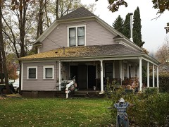 | James F. Bridwell House | building | 1989 | 88001446 |
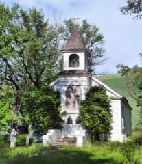 | St. Joseph's Mission | building | 1976 | 76000677 |
 | State Bank of Kamiah | building | 1978 | 78001082 |
Every wildfire the federal occurrence database records inside this county: 278 of them, burning about 96,646 acres. 123 started naturally and 11 were recorded as arson. Each settlement page carries the fires within five miles of it.
| Reported cause | Fires |
|---|---|
| Natural | 123 |
| Debris and open burning | 56 |
| Missing data/not specified/undetermined | 37 |
| Equipment and vehicle use | 28 |
| Arson/incendiarism | 11 |
| Recreation and ceremony | 6 |
| Fireworks | 6 |
| Smoking | 4 |
| Misuse of fire by a minor | 3 |
| Other causes | 2 |
| Railroad operations and maintenance | 1 |
| Power generation/transmission/distribution | 1 |
The five largest, by the area the report gives. None of them was recorded as arson.
| Date | Cause | Size | Reported by | Name on the report |
|---|---|---|---|---|
| 11 August 2000 | Natural | 64,510 acres | Wallowa-Whitman National Forest | MALONEY |
| 12 August 2015 | Natural | 21,640 acres | Nez Perce Tribe | FISHER |
| 14 August 2003 | Equipment and vehicle use | 4,000 acres | Nez Perce Tribe | MILEPOST |
| 19 August 1992 | Natural | 1,654 acres | Nez Perce Tribe | MARKER 62 |
| 6 August 2014 | Equipment and vehicle use | 630 acres | Nez Perce Tribe | GIFFORD |
| 26 September 2012 | Fireworks | 584 acres | Nez Perce Tribe | FLYING B |
| 7 March 2018 | Debris and open burning | 422 acres | Idaho Department of Lands | 7-MAR |
| 20 October 1993 | Debris and open burning | 250 acres | Idaho Department of Lands | LAPWAI CANYON |
Every settlement page carries the fires within five miles of it - see the settlement index below.
The NOAA Storm Events Database holds 51 reports for this county, causing no deaths, no injuries and about $572,000 in recorded property damage. Each settlement page carries the reports that name it.
| Kind of event | Reports |
|---|---|
| Hail | 24 |
| Thunderstorm Wind | 14 |
| Heavy Rain | 5 |
| Flood | 4 |
| Debris Flow | 3 |
| Tornado | 1 |
The most serious of them, by death, then injury, then recorded damage. The accounts are quoted exactly as the forecast office filed them.
| When | Event | Place named | Harm | What the report says |
|---|---|---|---|---|
| April 2024 | Debris Flow | Kamiah | $200,000 | Emergency manager reported debris flow over Highway 64. It closed the section of road between milepost 23 to 31. Cost of repair is estimated. |
| August 2022 | Hail | Forest | $100,000 | A strong thunderstorm moved Northeast from the Craig Mountain area through Kamiah ID. It brought large hail around 1 inch and wind damage. The wind damage included trees and power lines in the town of Kamiah and along highways 64, 12, and 162. A roof also fell onto a car. |
| April 2019 | Flood | Kamiah | $100,000 | High water in the Clearwater River augmented by a levee break along Lawyer Creek produced extensive flooding near the confluence of these two streams on the eastern edge of the city of Kamiah. The flood waters were reported to be waist deep in the Kamiah Riverfront Park. Flood waters also partially inundated a lumber yard, undermined a railroad grade and trestle crossing Lawyer Creek and high water prohibited access to the city's water plant. The levee was temporarily repaired by the public works department as the creek receded. |
| August 2017 | Thunderstorm Wind | Kamiah | $50,000 | A series of photographs from the Lewis County Emergency Manager indicated numerous trees down in Kamiah, with damage to outbuildings, a barn and at least one car in and around the town. |
| June 2010 | Heavy Rain | Kamiah | $32,000 | Road damage from heavy rain was observed on Drake, Gibler, Hull, Ida, Lawyer, McLead, Miller, and Z West roads. |
| August 2017 | Thunderstorm Wind | Nezperce | $20,000 | The Lewis County Emergency Manager reported 13 power poles knocked down and multiple transformers damaged along Highway 64 between Lyons Rd. and Marker Rd. Power was cut off to the area for 18 hours while repairs were made. Radar indicated a thunderstorm nearby which likely produced a strong microburst into the damage area. |
| June 2010 | Heavy Rain | Craigmont Arpt | $17,000 | Road damage from heavy rain was observed on Dunlap, Airport, Powerline, Fisher, and Laufer roads. |
| June 2010 | Heavy Rain | Slickpoo | $16,000 | Road damage from heavy rain was observed on Roberts, Sandhill, Wilsey, Tiede, Woodlawn, and Mission Creek roads. |
| April 2019 | Debris Flow | Kamiah | $10,000 | Several mud slides were reported over Highway 12 just west of Kamiah on the morning of April 9th. One of the slides completely covered the road and caused the temporary closure of this primary road through the region while crews cleared the debris. |
| June 2010 | Heavy Rain | Nezperce | $5,000 | Road damage from heavy rain was observed on Johnson and Synder roads. |
| April 2000 | Thunderstorm Wind | Nezperce | $5,000 | Tree uprooted by gusty winds. |
| November 2010 | Thunderstorm Wind | Winchester | $5,000 | no account filed |
| June 1999 | Hail | Craigmont | $5,000 | no account filed |
| July 2024 | Thunderstorm Wind | Kamiah | $2,000 | Avista reported approximately 600 without power in the Kamiah area due to thunderstorm wind gusts. Nearby observations show wind speeds around 45 to 55 mph. |
| June 2022 | Flood | Winchester | $2,000 | Two flooding issues noted in Winchester. For one property, a gravel driveway was washout due to a plugged culvert. On a neighboring property, a small pond rose six feet and over the roadway. Time of start of flooding was approximate 7pm. |
| December 2022 | Flood | Forest | $1,000 | Flooding out of a cross forest road water path about 50 to 60 feet wide about 3 inches deep in the Winchester area. Lewis County Sheriff reports that the road feels as if it is eroding as you are driving through it. |
| August 2017 | Thunderstorm Wind | Kamiah | $1,000 | Several trees uprooted and split, with large branches broken off due to thunderstorm winds. |
| December 2017 | Debris Flow | Kamiah | $1,000 | Heavy rain and snow melt saturated the ground and caused a Debris Flow near Kamiah. The mudslide cut and temporarily closed Idaho Highway 64 between Nez Perce and Kamiah. |
| July 2022 | Hail | Nezperce | - | Nickel to quarter size hail remains on the ground about 20 minutes after the storm moved through. |
| July 2022 | Hail | Nezperce | - | Public reported on social media. |
| July 2022 | Hail | Nezperce | - | Hail reported on social media. |
| August 2022 | Thunderstorm Wind | Craigmont | - | A downburst from a collapsing thunderstorm produced estimated wind gusts near 60 mph. Half inch hail also fell with the storm. |
| June 2016 | Hail | Craigmont | - | A member of the public reported 1.75 inch size hail at Craigmont, Idaho. |
| June 2016 | Hail | Winchester | - | A member of the public reported 1 inch size hail at Winchester, Idaho. |
| June 2016 | Hail | Craigmont | - | An other federal agency reported 1 inch size hail at Craigmont, Idaho. |
| June 2016 | Hail | Craigmont | - | A member of the public reported one inch size hail 3 miles southwest of Craigmont, Idaho. |
| May 2015 | Hail | Craigmont | - | A Facebook post noted 0.75 inch hail fell in Craigmont, ID. |
| May 2015 | Hail | Craigmont | - | A member of the public reported hail ranging from nickel to quarter size falling 3 miles south of Craigmont, WA. |
| August 2014 | Hail | Nezperce | - | One inch hail and gusty winds reported with thunderstorm. |
| September 2013 | Thunderstorm Wind | Nezperce | - | Tree fell onto some power lines and knocked out power to 115 customers. |
| April 2011 | Flood | Kamiah | - | Flooding of Lawyer's Creek resulted in closures of Lawyer's Creek Road between highway 162 and Flying B Ranch. The main creek split with one flow going toward Flying B Ranch where one resident reported at least one foot of water around his house. The rest of the creek flowed eastward to Robinson's Pond where it ate away at the levy between the pond and highway spilling about three feet of water over the road. |
| July 2010 | Thunderstorm Wind | Kamiah | - | Strong wind from a thunderstorm in Kamiah blew down several trees. |
| October 2010 | Tornado (EF0) | Harris Siding | - | A tornado was spotted for a brief period by the public just south of New Hope Road near Lawyer Canyon approximately six miles southeast of Craigmont. The tornado then moved into Idaho County (see Storm Data for Idaho). |
| May 1997 | Hail | Craigmont | - | 3/4 inch hail |
| September 2013 | Thunderstorm Wind | Winchester | - | no account filed |
| June 2012 | Hail | Slickpoo | - | no account filed |
| July 2012 | Thunderstorm Wind | Slickpoo | - | no account filed |
| July 2010 | Hail | Kamiah Muni Arpt | - | no account filed |
| June 2010 | Heavy Rain | Nezperce | - | no account filed |
| June 2007 | Hail | Winchester | - | no account filed |
| May 2002 | Hail | Winchester | - | no account filed |
| July 1983 | Hail | not stated | - | no account filed |
| July 1983 | Thunderstorm Wind | not stated | - | no account filed |
| July 1982 | Hail | not stated | - | no account filed |
| September 1979 | Hail | not stated | - | no account filed |
| July 1978 | Hail | not stated | - | no account filed |
| July 1975 | Hail | not stated | - | no account filed |
| July 1975 | Hail | not stated | - | no account filed |
| July 1971 | Thunderstorm Wind | not stated | - | no account filed |
| July 1970 | Hail | not stated | - | no account filed |
| July 1970 | Thunderstorm Wind | not stated | - | no account filed |
The Survey's mineral resources record lists 25 workings inside this county. 18 still produce and 7 are closed or unrecorded. Each settlement page carries the workings within five miles of it.
| Commodity | Workings |
|---|---|
| Sand and Gravel, Construction | 20 |
| Limestone, Dimension | 2 |
| Brick Clay | 1 |
| Limestone, Ultra Pure | 1 |
| Uranium | 1 |
| Stone | 1 |
The least common of them first, because a county's hundredth gravel pit says nothing its first ten did not.
| Where | Site | Commodity | Status | Recorded |
|---|---|---|---|---|
| Ida-Lew Construction | Uranium, Stone | Past Producer | ||
| Mission Creek Limestone | Limestone, Ultra Pure | Past Producer | 1942 | |
| Nez Perce Clay Prospect | Brick Clay | Past Producer | Clay | |
| Jacques Spur | Limestone, Dimension | Unknown | ||
| Nez Perce Limestone Quarry | Limestone, Dimension | Unknown | ||
| Borrow Pit | Sand and Gravel, Construction | Past Producer | ||
| Borrow Pit | Sand and Gravel, Construction | Past Producer | ||
| Craigmont Pit | Sand and Gravel, Construction | Producer | ||
| Gravel Pit | Sand and Gravel, Construction | Producer | ||
| Gravel Pit | Sand and Gravel, Construction | Producer | ||
| Gravel Pit | Sand and Gravel, Construction | Producer | ||
| Gravel Pit | Sand and Gravel, Construction | Producer | ||
| Gravel Pit | Sand and Gravel, Construction | Producer | ||
| Gravel Pit | Sand and Gravel, Construction | Producer | ||
| Gravel Pit | Sand and Gravel, Construction | Producer | ||
| Gravel Pit | Sand and Gravel, Construction | Producer | ||
| Gravel Pit | Sand and Gravel, Construction | Producer | ||
| Gravel Pit | Sand and Gravel, Construction | Producer | ||
| Gravel Pit | Sand and Gravel, Construction | Producer | ||
| Gravel Pit | Sand and Gravel, Construction | Producer | ||
| Gravel Pit | Sand and Gravel, Construction | Producer | ||
| Gravel Pit | Sand and Gravel, Construction | Producer | ||
| Gravel Pit | Sand and Gravel, Construction | Producer | ||
| Gravel Pit | Sand and Gravel, Construction | Producer | ||
| Gravel Pit | Sand and Gravel, Construction | Producer |
Named settlements recorded in the Geographic Names Information System, each with the topographic sheets covering it. Villages, hamlets and abandoned places alike. Each is shown with the nearest named watercourse or landform and the survey quadrangle it falls on.
Winchester census division · 83548 · Near Coldsprings Canyon · Reubens quadrangle
9 sheets, 1955 to 1984
Winchester census division · 83523 · Near Coldsprings Canyon · Reubens quadrangle
9 sheets, 1955 to 1984
Craigmont census division · 83523 · Craigmont quadrangle
8 sheets, 1924 to 1981
No longer a settlement
South Lewis census division · 83523 · On North Fork Willow Creek · Winchester East quadrangle
8 sheets, 1955 to 1981
Winchester census division · 83524 · Near Hamilton Canyon · Culdesac South quadrangle
9 sheets, 1955 to 1985
Winchester census division · 83524 · Reubens quadrangle
9 sheets, 1955 to 1984
No longer a settlement
The vanished settlements of Lewis County: the places named above that are no longer on the map.