 Block
From the record
5 National Register listings published here.
Sources: the National Register database, National Park Service
36 topographic sheets cover 18 settlements here, and 5 properties are on the National Register of Historic Places.
5 National Register listings published here.
Sources: the National Register database, National Park Service
Every property in this county listed on the National Register of Historic Places, with the year it was listed and the federal nomination document.
| Photograph | Property | Type | Listed | Reference |
|---|---|---|---|---|
| Hollingshead Homestead | building | 2006 | 06000002 | |
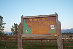 | Pierre's Hole 1832 Battle Area Site | site | 1984 | 84001197 |
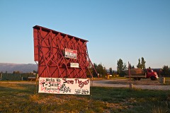 | Spud Drive-In Theater | district | 2003 | 99001475 |
 | Teton County Courthouse | building | 1987 | 87001589 |
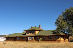 | Victor Railroad Depot | building | 1995 | 95000508 |
Every wildfire the federal occurrence database records inside this county: 64 of them, burning about 270 acres. 40 started naturally and 1 was recorded as arson. Each settlement page carries the fires within five miles of it.
| Reported cause | Fires |
|---|---|
| Natural | 40 |
| Recreation and ceremony | 14 |
| Missing data/not specified/undetermined | 4 |
| Equipment and vehicle use | 3 |
| Debris and open burning | 2 |
| Arson/incendiarism | 1 |
The five largest, by the area the report gives. None of them was recorded as arson.
| Date | Cause | Size | Reported by | Name on the report |
|---|---|---|---|---|
| 18 October 1996 | Debris and open burning | 100 acres | Caribou-Targhee National Forest | DUDE CREEK |
| 1 September 2002 | Recreation and ceremony | 93 acres | Idaho Falls District | FELT |
| 9 August 2007 | Natural | 38 acres | Caribou-Targhee National Forest | LITTLE BURNS |
| 13 September 1994 | Natural | 10 acres | Idaho Falls District | LINDERMAN |
| 16 August 2020 | Missing data/not specified/undetermined | 5.8 acres | Idaho Falls District | FELT DAM |
| 7 May 2007 | Missing data/not specified/undetermined | 4.0 acres | Idaho Falls District | HORSESHOE |
| 30 September 1996 | Debris and open burning | 3.0 acres | Caribou-Targhee National Forest | MCREYNOLDS |
| 17 August 2001 | Natural | 3.0 acres | Caribou-Targhee National Forest | MCREYNOLDS |
Every settlement page carries the fires within five miles of it - see the settlement index below.
The NOAA Storm Events Database holds 71 reports for this county, causing no deaths, no injuries and about $230,230 in recorded property damage. Each settlement page carries the reports that name it.
| Kind of event | Reports |
|---|---|
| Thunderstorm Wind | 38 |
| Hail | 17 |
| Funnel Cloud | 4 |
| Flood | 4 |
| Lightning | 3 |
| Flash Flood | 3 |
| Tornado | 1 |
| Heavy Rain | 1 |
The most serious of them, by death, then injury, then recorded damage. The accounts are quoted exactly as the forecast office filed them.
| When | Event | Place named | Harm | What the report says |
|---|---|---|---|---|
| February 2017 | Flood | Judkins | $90,000 | Some minor sheet flooding occurred at low elevations along with some road damage aided in part by the cold and snowy winter after the warmup in February. |
| July 1999 | Lightning | Driggs | $21,000 | Lightning struck a lone tree, killing all 15 head of cattle which had gathered about it. |
| October 2013 | Lightning | Tetonia | $20,000 | Lightning struck a tree that was connected to a barbed wire fence on a ranch in Tetonia. The current from the fence killed 15 cattle lined up next to the fence. Cost to the rancher was between 15 and 20 thousand dollars. |
| May 2017 | Flood | Judkins | $17,000 | Minor flooding occurred in May with snow melt being the main contributor to the flooding. Field flooding caused agricultural damage and many roads and recreational facilities received damage. |
| June 2017 | Flood | Judkins | $11,000 | Minor flooding continued in June with snow melt being the main contributor to the flooding. Field flooding caused agricultural damage and many roads and recreational facilities received damage. |
| July 2023 | Thunderstorm Wind | Tetonia | $10,000 | Three power poles damaged with one snapped off halfway up. Multiple large trees were downed. |
| July 2023 | Thunderstorm Wind | Driggs | $6,000 | Idaho Highway 33 was blocked in both directions at milepost 141 due to multiple power lines downed. |
| August 2022 | Thunderstorm Wind | Driggs | $6,000 | Several trees were downed at the Teton County Courthouse in Driggs. One tree took down a light pole. |
| September 2025 | Thunderstorm Wind | Felt | $5,000 | Multiple trees reported downed in Felt. |
| July 2023 | Thunderstorm Wind | Driggs | $5,000 | Numerous large trees snapped off at various heights along Willowbrook Dr. |
| July 2023 | Thunderstorm Wind | Driggs | $3,500 | Seven trees were downed in Valley Centre Dr neighborhood. All were snapped off at roots at or just below ground level. One was 2 feet in diameter and others 1 foot in diameter. One tree blocked Valley Centre Dr at Idaho Highway 33. |
| May 2025 | Thunderstorm Wind | Victor | $3,000 | Several trees reported down in the Game Creek area off of Old Jackson Highway southeast of Victor. |
| May 2025 | Thunderstorm Wind | Tetonia | $3,000 | A large section of siding was blown off residence near Totonia with a private weather station recording a 60 mph wind gust. |
| July 2023 | Thunderstorm Wind | Tetonia | $3,000 | Three large trees, one cottonwood and two aspens, blown down in driveway along N 1000 E south of E 7000 N. One tree 16 inches in diameter. |
| July 2023 | Thunderstorm Wind | Driggs | $3,000 | Large pine tree estimated at 2 feet in diameter snapped off less than half way up from the ground near the intersection of Ski Hill Rd and Mountain Vista Dr. |
| May 2016 | Thunderstorm Wind | Driggs | $3,000 | A 61 mph wind gust was measured at 4:05 PM 2 miles north of Driggs with 4 power poles downed along 2500 N. Power was out for 6 hours north of the airport. |
| July 2023 | Thunderstorm Wind | Tetonia | $2,000 | Roof shingles peeled up on a home near N 3000 W and W 4000 N. |
| July 2023 | Thunderstorm Wind | Driggs | $2,000 | Small portion of roof peeled off the Wardrobe business along Idaho Highway 33. |
| July 2023 | Thunderstorm Wind | Driggs | $2,000 | Small tree downed on a pickup tree off of Clubmoss Ln. |
| September 2022 | Thunderstorm Wind | Victor | $2,000 | Power lines were reported down with damage to power pole in Victor. |
| June 2011 | Flash Flood | Felt | $2,000 | Heavy rain on top of snowmelt caused Badger Crerek to flood causing damage to County Road 10000 North. It was closed for several weeks. |
| July 2023 | Thunderstorm Wind | Tetonia | $1,500 | Four foot by 4 foot tarp ripped in half. Phone line taken off a residence with greenhouse damage at Tetonia elementary school. |
| July 2025 | Thunderstorm Wind | Tetonia | $1,000 | A tree was downed on a power line near Tetonia causing a power outage in the area. |
| August 2024 | Thunderstorm Wind | Driggs | $1,000 | A large aspen tree was downed near Horseshoe Canyon. |
| July 2023 | Thunderstorm Wind | Tetonia | $1,000 | A wood and sheet metal horse shed with ground anchors 4 feet deep pulled out of the ground in the area of N 4500 W and 6000 N. |
| July 2023 | Thunderstorm Wind | Tetonia | $1,000 | A power pole was damaged and leaning along E 4000 N. |
| July 2023 | Thunderstorm Wind | Driggs | $1,000 | Pine tree uprooted and down on a trailer home. |
| July 2023 | Thunderstorm Wind | Driggs | $1,000 | A large tree 2 feet in diameter down along Ashley Avenue between N 1st St and Idaho Highway 33. |
| July 2023 | Thunderstorm Wind | Victor | $1,000 | Wood and sheet metal horse shelter flipped over with posts snapped at ground level and trees down . In Fox Creek off of S 1000 E. |
| May 2003 | Thunderstorm Wind | Clementsville | $1,000 | no account filed |
| July 2023 | Thunderstorm Wind | Driggs | $500 | Tree 1.5 feet in diameter snapped off at base on Goldshire Drive. |
| July 2023 | Thunderstorm Wind | Victor | $300 | Tents damaged and destroyed at the craft fair in Victor City Park. |
| September 2024 | Flash Flood | Driggs | $200 | A NWS employee reported significant water running along the shoulders of Idaho 33 in Driggs due to heavy rainfall from thunderstorms. Street flooding in the area of 3rd St and Little Ave. |
| June 2024 | Flood | Victor | $100 | Widespread rainfall amounts of 0.75 to 1.25 inches was reported in the Victor area. Road flooding reported along 6000 S and Idaho 33 and along W 6000 S and S 500 W. Water was running over Idaho 33 at milepost 146.8. Some homes were affected by water going over Idaho 33 along Fox Creek. |
| June 2024 | Lightning | Victor | $100 | Fall River Rural Electric Cooperative reported a lightning strike knocked out power to several hundred customers in the areas of Idaho 33 and W 5000 S for about an hour near Victor. |
| June 1954 | Tornado | not stated | $30 | no account filed |
| April 2026 | Thunderstorm Wind | Clementsville | - | The Relay Ridge mesonet site recorded a 60 mph thunderstorm outflow wind gust. |
| April 2026 | Thunderstorm Wind | Clementsville | - | The Relay Ridge mesonet site recorded a 59 mph thunderstorm outflow wind gust. |
| May 2025 | Thunderstorm Wind | Clementsville | - | The Botts ITD site on Idaho 33 recorded a 62 mph wind gust. |
| April 2024 | Thunderstorm Wind | Clementsville | - | The River Rim RWIS site recorded 58 mph. |
| April 2024 | Thunderstorm Wind | Felt | - | Private weather station recorded 59 mph gust. |
| July 2023 | Thunderstorm Wind | Driggs Muni Arpt | - | A 58 mph wind gust measured by the AWOS at the Driggs Airport. |
| July 2023 | Thunderstorm Wind | Driggs | - | Fall River Rural Electric reported 26 customers without power in downtown Driggs. |
| July 2023 | Thunderstorm Wind | Tetonia | - | Two-hundred sixteen customers without power in the Tetonia area reported by Fall River Electric Cooperative. |
| June 2022 | Funnel Cloud | Tetonia | - | A funnel cloud photographed just north and northwest of Tetonia. |
| June 2022 | Funnel Cloud | Tetonia | - | A funnel cloud photographed west of Tetonia. |
| May 2020 | Thunderstorm Wind | Victor | - | A 60 mph wind gust measured at the Pine Creek Pass ITD site. |
| April 2020 | Thunderstorm Wind | Clementsville | - | A 63 mph gust measured at Botts mesonet station. |
| June 2015 | Hail | Tetonia | - | Large hail measuring 1.25 inches was recorded in Tetonia. |
| June 2015 | Flash Flood | Victor | - | Heavy rains from a thunderstorm caused several inches of water to collect on roads and residential areas in the town of Victor. No damage reports were received. |
| August 2014 | Heavy Rain | Judkins | - | Farmers and ranchers in Teton County were declared by the USDA to qualify for natural disaster assistance due to crop damage from heavy August rains. Eastern Idaho barley crop damage was estimated at 64 million dollars with a portion of that in Teton County. |
| May 2014 | Hail | Victor | - | One inch hail fell in Victor verified by a National Weather Service employee in the area. |
| May 2014 | Hail | Tetonia | - | Tetonia received 1.75 inch hail from a severe thunderstorm. |
| July 2008 | Hail | Victor | - | Extensive quarter sized hail near Victor. |
| July 2008 | Hail | Victor | - | Quarter sized hail in Victor. |
| July 2008 | Hail | Driggs | - | Nickel sized hail at Driggs. |
| September 2000 | Funnel Cloud | Driggs | - | Two funnel clouds spotted. |
| May 1997 | Funnel Cloud | Driggs | - | Teton County Sheriff reported a funnel cloud about 4 miles southwest of Driggs which extended only a few hundred feet from base of cloud and did not touch the ground. The thunderstorm associated with this funnel also produced pea-size hail. |
| June 2006 | Hail | Driggs | - | no account filed |
| July 2004 | Hail | Victor | - | no account filed |
The Survey's mineral resources record lists 48 workings inside this county. None of them still produces: all are closed or unrecorded. Each settlement page carries the workings within five miles of it.
| Commodity | Workings |
|---|---|
| Sand and Gravel, Construction | 21 |
| Phosphorus-Phosphates | 12 |
| Limestone, General | 5 |
| Pumice | 3 |
| Bituminous, Uranium | 1 |
| Vanadium | 1 |
| Chromium, Phosphorus-Phosphates, Vanadium | 1 |
| Chromium, Vanadium, Phosphorus-Phosphates | 1 |
| Uranium, Bituminous | 1 |
| Vanadium, Phosphorus-Phosphates | 1 |
| Scandium | 1 |
| Sulfur | 1 |
The least common of them first, because a county's hundredth gravel pit says nothing its first ten did not.
| Where | Site | Commodity | Status | Recorded |
|---|---|---|---|---|
| Cluff Tunnels | Bituminous, Uranium | Occurrence | Sedimentary | |
| Gravel Pit | Scandium | Past Producer | ||
| Pine Creek Pass Coal Prospect | Uranium, Bituminous | Occurrence | 1912 | |
| Piney Peak Phosphate Deposit | Chromium, Vanadium, Phosphorus-Phosphates | Occurrence | ||
| Sulphur Sprs | Sulfur | Occurrence | ||
| Trench D Phosphate Occurrence | Vanadium, Phosphorus-Phosphates | Occurrence | ||
| Trench E Phosphate Occurrence | Chromium, Phosphorus-Phosphates, Vanadium | Occurrence | ||
| Trench K Phosphate Occurrence | Phosphorus-Phosphates, Vanadium | Occurrence | ||
| Pumice Deposit | Pumice | Past Producer | Pumice | |
| Pumice Deposit | Pumice | Past Producer | Pumice | |
| Pumice Deposit | Pumice | Past Producer | Pumice | |
| Limestone Deposit | Limestone, General | Occurrence | Limestone | |
| Mike Harris Creek Limestone Deposit | Limestone, General | Occurrence | Limestone | |
| Packsaddle Basin Limestone | Limestone, General | Occurrence | ||
| Packsaddle Basin Limestone Deposit | Limestone, General | Occurrence | Limestone | |
| Pole Canyon Limestone Mine | Limestone, General | Past Producer | Limestone | |
| Moose Creek | Phosphorus-Phosphates | Unknown | ||
| Patterson Creek Phosphate Deposit | Phosphorus-Phosphates | Prospect | ||
| Phosphate Occurrence | Phosphorus-Phosphates | Occurrence | ||
| Phosphate Occurrence | Phosphorus-Phosphates | Occurrence | ||
| Trench C. Phosphate Occurrence | Phosphorus-Phosphates | Occurrence | ||
| Trench F Phosphate Occurrence | Phosphorus-Phosphates | Occurrence | ||
| Unnamed Location | Phosphorus-Phosphates | Prospect | ||
| Unnamed Prospect | Phosphorus-Phosphates | Prospect | ||
| Unnamed Prospect | Phosphorus-Phosphates | Prospect | ||
| Unnamed Prospect | Phosphorus-Phosphates | Prospect | ||
| Victor Trench | Phosphorus-Phosphates | Prospect | ||
| Gravel Pit | Sand and Gravel, Construction | Past Producer | ||
| Gravel Pit | Sand and Gravel, Construction | Past Producer | ||
| Gravel Pit | Sand and Gravel, Construction | Past Producer | ||
| Gravel Pit | Sand and Gravel, Construction | Past Producer | ||
| Gravel Pit | Sand and Gravel, Construction | Past Producer | ||
| Gravel Pit | Sand and Gravel, Construction | Past Producer | ||
| Gravel Pit | Sand and Gravel, Construction | Past Producer | ||
| Gravel Pit | Sand and Gravel, Construction | Past Producer | ||
| Gravel Pit | Sand and Gravel, Construction | Past Producer | ||
| Gravel Pit | Sand and Gravel, Construction | Past Producer | ||
| Gravel Pit | Sand and Gravel, Construction | Past Producer | ||
| Gravel Pit | Sand and Gravel, Construction | Past Producer | ||
| Gravel Pit | Sand and Gravel, Construction | Past Producer | ||
| Gravel Pit | Sand and Gravel, Construction | Past Producer | ||
| Gravel Pit | Sand and Gravel, Construction | Past Producer | ||
| Gravel Pit | Sand and Gravel, Construction | Past Producer | ||
| Gravel Pit | Sand and Gravel, Construction | Past Producer | ||
| Gravel Pit | Sand and Gravel, Construction | Past Producer | ||
| Gravel Pit | Sand and Gravel, Construction | Past Producer | ||
| Gravel Pit | Sand and Gravel, Construction | Past Producer | ||
| Gravel Pit | Sand and Gravel, Construction | Past Producer |
Named settlements recorded in the Geographic Names Information System, each with the topographic sheets covering it. Villages, hamlets and abandoned places alike. Each is shown with the nearest named watercourse or landform and the survey quadrangle it falls on.
Driggs census division · 83422 · On South Twin Creek · Bates quadrangle
13 sheets, 1943 to 1988
Victor census division · 83455 · On Grove Creek · Fourth of July Peak quadrangle
13 sheets, 1943 to 1988
Tetonia census division · 83452 · On Little Dry Creek · Clawson quadrangle
10 sheets, 1955 to 1988
Tetonia census division · 83452 · Tetonia quadrangle
10 sheets, 1955 to 1988
No longer a settlement
Driggs census division · 83422 · On Bell Creek · Garns Mountain quadrangle
13 sheets, 1943 to 1988
Tetonia census division · 83452 · On Middle Leigh Creek · Tetonia quadrangle
10 sheets, 1955 to 1988
Victor census division · 83455 · Near Sweet Hollow · Victor quadrangle
14 sheets, 1943 to 1988
Driggs census division · 83422 · On North Twin Creek · Bates quadrangle
13 sheets, 1943 to 1988
Driggs census division · 83422 · On Woods Creek · Bates quadrangle
13 sheets, 1943 to 1988
The vanished settlements of Teton County: the places named above that are no longer on the map.