
BlockBefore
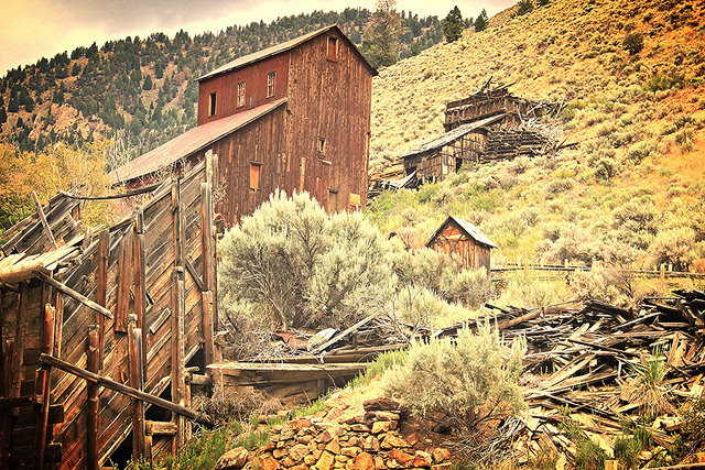
Photograph of Bayhorse
Photograph by Sassygirljenna, CC BY-SA 4.0. Via Wikimedia Commons.

Bayhorse

Listed on the National Register of Historic Places in 1976.

From the record

“Bayhorse is a ghost town in Custer County, Idaho, United States, founded in 1877, though active development of the town did not begin until 1880. Bayhorse was once a thriving mining town, principally supported by large nearby silver deposit.”

Wikipedia article Bayhorse, Idaho, CC BY-SA 4.0.

One of 33 National Register listings published here for Custer County · listed in 1976 · category: Building.

Sources: the Wikipedia article · the case file at the National Archives · the National Register database, National Park Service · the Wikipedia article

The listing

  • Address. S of Challis off U.S. 93, Challis, 83226
  • When was it listed? March 1976
  • Category. building
  • Census division. Challis
  • National Register reference number. 76000671 - the number the National Park Service assigned this property when it was listed, and the key its nomination file is catalogued under at the National Archives.

Fires near this property

25 since 1992

Regional context, not property-specific evidence. The federal wildfire occurrence database lists 25 fires within 5 miles of Bayhorse between 1992 and 2020, burning about 178 acres in total. 13 started naturally. None was recorded as arson. Distance is straight-line from the map coordinates, so a fire counted here may appear on a neighbouring settlement's page as well.

Reported cause Fires
Natural13
Recreation and ceremony5
Missing data/not specified/undetermined4
Debris and open burning2
Equipment and vehicle use1

The most recent of them, most recent first, with the day each was reported and the service that recorded it.

DateCause SizeReported by Name on the report
7 August 2016Naturalunder an acreSalmon-Challis National ForestBULL
4 August 1997Debris and open burningunder an acreSalmon-Challis National ForestBAYHORSE
27 August 2020Naturalunder an acreIdaho Falls DistrictPACIFIC
25 August 1995Naturalunder an acreSalmon-Challis National ForestHAPPY HOLLOW
2 August 1996Naturalunder an acreSalmon-Challis National ForestBOULDER
12 August 1993Naturalunder an acreSalmon-Challis National Forestnot named
1 August 1994Naturalunder an acreSalmon-Challis National Forestnot named
9 July 1994Natural118 acresSalmon-Challis National ForestBLUE MOUNTAIN

Every fire recorded in Custer County

Mines and quarries near this property

10 of 42 shown

Regional context, not property-specific evidence. The federal mineral resources record lists 42 workings within 5 miles of Bayhorse: 21 past producers, 15 prospects, 4 occurrences, 2 producers. 2 still produce. What was taken out: Lead, Fluorine-Fluorite, Silver, Gold. Distance is straight-line from the map coordinates, so a quarry counted here may appear on a neighbouring settlement's page as well.

Where SiteCommodity StatusRecorded
Bayhorse DistrictCopper, Lead, Zinc, Silver, TungstenProducerHYDROTHERMAL REPLACEMENT, VEINS
Bayhorse LeadLead, Copper, Gold, Silver, ZincPast Producer
Beardsley MineLead, Gold, Zinc, Copper, SilverPast ProducerCopper
Cave MineLead, Silver, Copper, GoldPast ProducerVein
Democrat ProspectLead, Silver, Gold, CopperPast ProducerReplacement
Dougherty GroupLead, Copper, SilverPast ProducerVein
Forest Rose MineGold, Copper, Silver, LeadPast ProducerReplacement
Js ProspectZinc, LeadProspect
Julliette LodeLead, Zinc, Silver, Gold, CopperProspect
Keno MineGold, Lead, Silver, Fluorine-FluoritePast Producer

Every working recorded in Custer County

Storms near this property

18 since 1995

Regional context, not property-specific evidence. The National Weather Service names Challis, the town this property stands in, in 18 storm reports between 1995 and 2025: 9 thunderstorm wind, 6 flash flood, 1 hail, 1 tornado. No death or injury is recorded in these reports. Each account below is quoted exactly as the forecast office filed it, from the NOAA Storm Events Database, and each date opens the federal record of that event.

WhenEvent Place namedHarm What the report says
July 1995Thunderstorm WindChallis$5,000no account filed
July 2008Thunderstorm WindChallis$3,000Tree downed on a house in Challis with a reported 61 mph wind gust. Power was knocked out for 2 hours in the entire city of Challis.
August 2023Thunderstorm WindChallis$1,000Tree blown down in Challis in 60 mph wind gusts.
September 2010Thunderstorm WindChallis$1,000Wind gusts estimated over 60 mph uprooted a large spruce tree in Challis and it took out a Custer Telephone cable TV line. Salmon River Electric reported power outages in the Yankee Fork and Rod and Gun Club areas. The Yankee Fork outage was due to a tree falling on the Yankee Fok distribution line. About 50 people lost power for 3 hours. Times estimated from newspaper and ASOS reports in the area.
April 2008Tornado (EF0)Challis$1,000A tornado was reported 2 miles north of Challis. It removed and destroyed a roof on a house.
May 2025Thunderstorm WindChallis-A 58 mph wind gust recorded by spotter in Challis.
September 2025Flash FloodChallis-A mudslide occurred in Custer County on Bayhorse Creek Rd about 1 mile from the Bayhorse town site. One to one and a half inches of rain fell in a two hour period.
August 2023Debris FlowChallis-Heavy rain caused a landslide blocking all lanes of Highway 75 near US Highway 93 south of Challis.
August 2023Thunderstorm WindChallis-Trained spotter had a 61 mph wind gust.
August 2021Flash FloodChallis-Idaho Transportation Department reported multiple mudslides and rock falls along US 93 between Evans and McKim Creek roads.
September 2019Thunderstorm WindChallis-A 61 mph wind gust measured in Challis.
July 2013Flash FloodChallis-Custer County Sheriffs office reported 1 foot of water near Garden Creek affecting power and telephone poles.
July 2011Flash FloodChallis-Rainfall of 0.30 inches in 15 minutes caused extensive street flooding in the city of Challis.
July 2008Flash FloodChallis-The Morgan Creek area had several roads washed out by heavy rains.
July 2007HailChallis-Three-quarter inch hail reported in Challis.
July 2007Flash FloodChallis-Rainfall of over 1 inch in less than one hour caused three mudslides along highway 75 in Challis.
July 1995Thunderstorm WindChallis-In Challis strong winds downed trees and power lines causing the power to go out.
July 1996Thunderstorm WindChallis-no account filed

Every storm recorded in Custer County

Map coverage status

No historic map-sheet match is published for this property yet. That does not mean no map exists. This record needs a coordinate-quality review before it can be joined to a sheet boundary. Browse the county's mapped places while that work is pending.

Sources for this property

National Archives recordThe nomination case file for reference 76000671 in Record Group 79.
Wikipedia articleCommunity-written account of this property, licensed CC BY-SA.
Custer CountyAll 33 listed properties in this county.

Provenance

  • Listing record. National Park Service National Register of Historic Places, listed-properties dataset, current to 2026-05-22.
  • Map join. Address geocoded through the United States Census geocoder, then tested against the published boundary of every sheet in the USGS Historical Topographic Map Collection.
  • How this page is made. Listing fields come from federal records; map-sheet coverage is a labelled coordinate-to-boundary calculation, not a source-field claim.
  • Wildfire. Short, Karen C. 2022. Spatial wildfire occurrence data for the United States, 1992-2020 [FPA_FOD_20221014]. 6th Edition. Fort Collins, CO: Forest Service Research Data Archive. https://doi.org/10.2737/RDS-2013-0009.6 Collected with United States Government funding and usable without additional permissions or fees.
  • Mines and quarries. USGS Mineral Resources Data System (MRDS) https://mrdata.usgs.gov/mrds/ A work of the United States government, no copyright under 17 U.S.C. 105.
  • Storms. NOAA National Centers for Environmental Information, Storm Events Database https://www.ncei.noaa.gov/stormevents/ A work of the United States government, no copyright under 17 U.S.C. 105. Narratives are quoted verbatim from the National Weather Service report and are not edited or summarised.