 Block
From the record
One of 11 National Register listings published here for Owyhee County · listed in 1978 · category: Building.
Sources: the case file at the National Archives · the National Register database, National Park Service
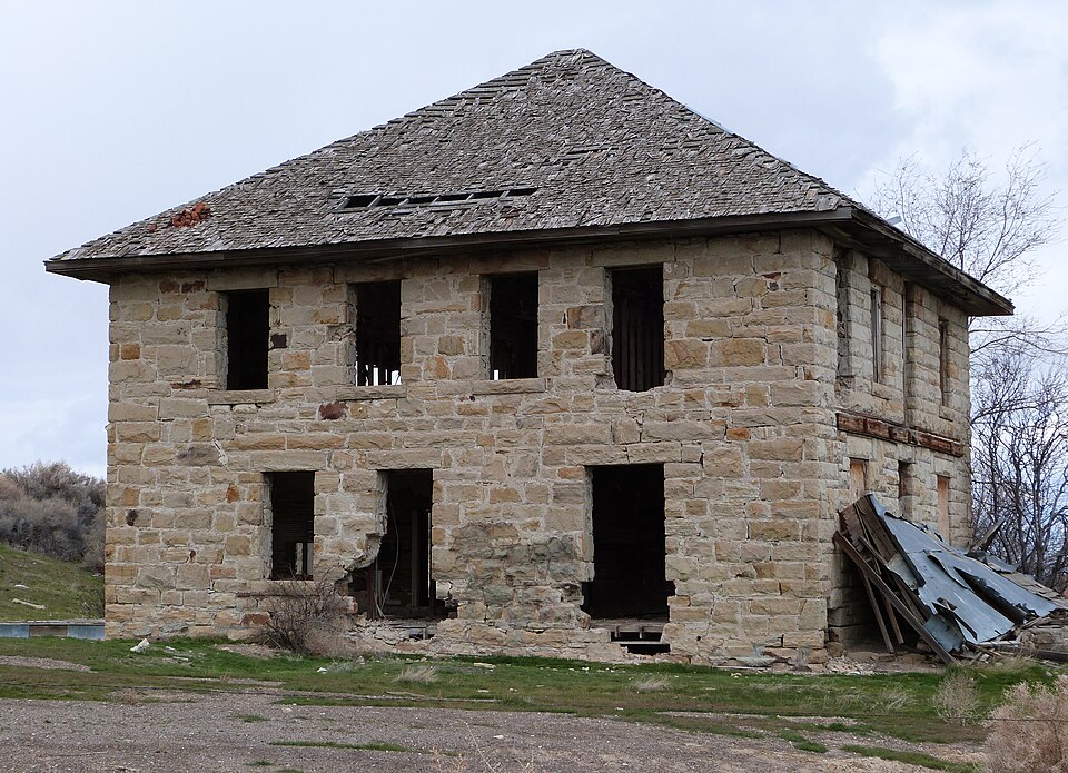
Listed on the National Register of Historic Places in 1978.
One of 11 National Register listings published here for Owyhee County · listed in 1978 · category: Building.
Sources: the case file at the National Archives · the National Register database, National Park Service
Regional context, not property-specific evidence. The federal wildfire occurrence database lists 17 fires within 5 miles of Poison Creek Stage Station between 1994 and 2020, burning about 3,203 acres in total. 1 started naturally. None was recorded as arson. Distance is straight-line from the map coordinates, so a fire counted here may appear on a neighbouring settlement's page as well.
| Reported cause | Fires |
|---|---|
| Missing data/not specified/undetermined | 4 |
| Firearms and explosives use | 3 |
| Fireworks | 3 |
| Equipment and vehicle use | 3 |
| Recreation and ceremony | 2 |
| Natural | 1 |
| Smoking | 1 |
The most recent of them, most recent first, with the day each was reported and the service that recorded it.
| Date | Cause | Size | Reported by | Name on the report |
|---|---|---|---|---|
| 9 September 2002 | Missing data/not specified/undetermined | 4.0 acres | Boise District | BURNTBLANK |
| 5 September 2011 | Smoking | 33 acres | Boise District | JUMP |
| 24 August 2007 | Missing data/not specified/undetermined | 11 acres | Boise District | POISON |
| 7 July 1996 | Fireworks | 522 acres | Boise District | JUMPCK. |
| 27 July 1996 | Missing data/not specified/undetermined | 68 acres | Boise District | TRIPLEJUMP |
| 25 July 1996 | Equipment and vehicle use | 7.0 acres | Boise District | JUMP 2 |
| 20 July 2014 | Recreation and ceremony | under an acre | Boise District | JUMPER |
| 2 July 1994 | Fireworks | 2.0 acres | Boise District | JUMP CK. |
Regional context, not property-specific evidence. The federal mineral resources record lists 4 workings within 5 miles of Poison Creek Stage Station: 2 unknowns, 1 occurrence, 1 past producer. None of them still produces. What was taken out: Sand and Gravel, Construction, Cobalt, Sodium, Halite, Mercury, Semiprecious Gemstone. Distance is straight-line from the map coordinates, so a quarry counted here may appear on a neighbouring settlement's page as well.
| Where | Site | Commodity | Status | Recorded |
|---|---|---|---|---|
| Claytonia Saline Deposit | Cobalt, Sodium, Halite | Occurrence | 1914 | |
| McD Mine | Mercury, Semiprecious Gemstone | Past Producer | Cinnabar | |
| Gravel Pit | Sand and Gravel, Construction | Unknown | ||
| Gravel Pit | Sand and Gravel, Construction | Unknown |
Regional context, not property-specific evidence. The National Weather Service names Homedale, the town this property stands in, in 7 storm reports between 1995 and 2020: 3 thunderstorm wind, 2 flash flood, 1 flood, 1 wildfire. No death or injury is recorded in these reports. Each account below is quoted exactly as the forecast office filed it, from the NOAA Storm Events Database, and each date opens the federal record of that event.
| When | Event | Place named | Harm | What the report says |
|---|---|---|---|---|
| April 1995 | Thunderstorm Wind | Homedale | $50,000 | no account filed |
| May 2020 | Thunderstorm Wind | Homedale | - | A resident in Homedale reported metal roofing bent and and portions ripped off, and downed trees. |
| June 2004 | Flash Flood | Homedale | - | Urban flooding in town. |
| July 2004 | Flash Flood | Homedale | - | Heavy rain from slow moving Thunderstorms caused Sage Creek to over flow its banks, nearby homes were threatened with flooding and a section of a road in the area was washed out. |
| July 2002 | Wildfire | Homedale | - | The Trimbly Creek Fire was started by lightning in eastern Malheur County, Oregon and was quickly spread by strong winds to within 7 miles of Homedale, Idaho. A mile wide flaming front threatened several ranches and Succor Creek Campground, which were evacuated until the fire was contained on July 15th. Over 46,000 acres burned but no structures were lost. |
| May 1998 | Flood | Homedale | - | Scattered heavy showers and thunderstorms over south west Idaho produced small stream flooding in Owyhee County during the afternoon of May 13th. Flood waters from Catherine Creek washed out a bridge near Grandview. Small stream flooding was also reported on Succor Creek and Sheep Creek near Homedale. Reported damage was minor and confined mainly to roads and farm land. |
| July 1998 | Thunderstorm Wind | Homedale | - | Severe thunderstorm winds downed trees in Homedale. |
No historic map-sheet match is published for this property yet. That does not mean no map exists. This record needs a coordinate-quality review before it can be joined to a sheet boundary. Browse the county's mapped places while that work is pending.
| National Archives record | The nomination case file for reference 78001089 in Record Group 79. |
| Owyhee County | All 11 listed properties in this county. |