 Block
From the record
3 National Register listings published here, 1 of them a National Historic Landmark.
Sources: the National Register database, National Park Service
65 topographic sheets cover 24 settlements here, and 3 properties are on the National Register of Historic Places.
3 National Register listings published here, 1 of them a National Historic Landmark.
Sources: the National Register database, National Park Service
Every property in this county listed on the National Register of Historic Places, with the year it was listed and the federal nomination document.
| Photograph | Property | Type | Listed | Reference |
|---|---|---|---|---|
 | Brussels Historic District | district | 1998 | 98000981 |
 | GOLDENROD | structure | 67000029 | |
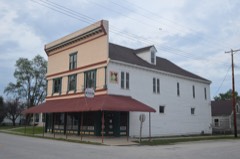 | Kamp Store | building | 1994 | 94000027 |
Every wildfire the federal occurrence database records inside this county: 15 of them, burning about 90 acres. None started naturally and none was recorded as arson. Each settlement page carries the fires within five miles of it.
| Reported cause | Fires |
|---|---|
| Debris and open burning | 13 |
| Power generation/transmission/distribution | 1 |
| Missing data/not specified/undetermined | 1 |
The five largest, by the area the report gives. None of them was recorded as arson.
| Date | Cause | Size | Reported by | Name on the report |
|---|---|---|---|---|
| 21 March 2014 | Debris and open burning | 39 acres | Two Rivers National Wildlife Refuge | CALHOUN WETLANDS |
| 24 February 2017 | Debris and open burning | 15 acres | Illinois Division of Forestry Resources | WALLENDORF TRUST/CACHE HOLLOW RD |
| 20 April 2019 | Debris and open burning | 6.0 acres | Illinois Division of Forestry Resources | 19-006 |
| 28 November 2017 | Debris and open burning | 5.0 acres | Illinois Division of Forestry Resources | ALAN TOPPMEYER 201714 |
| 3 April 1996 | Missing data/not specified/undetermined | 5.0 acres | Two Rivers National Wildlife Refuge | 96-01 |
| 21 March 2017 | Debris and open burning | 5.0 acres | Illinois Division of Forestry Resources | ADAM BAILEY |
| 15 March 2018 | Debris and open burning | 5.0 acres | Illinois Division of Forestry Resources | MARGARET PIKE |
| 11 April 2018 | Debris and open burning | 3.0 acres | Illinois Division of Forestry Resources | JEFFERY RUYLE |
Every settlement page carries the fires within five miles of it - see the settlement index below.
The NOAA Storm Events Database holds 142 reports for this county, causing no deaths, 5 injuries and about $517,130 in recorded property damage. Each settlement page carries the reports that name it.
| Kind of event | Reports |
|---|---|
| Thunderstorm Wind | 76 |
| Hail | 32 |
| Flash Flood | 13 |
| Tornado | 10 |
| Flood | 8 |
| Heavy Rain | 2 |
| Funnel Cloud | 1 |
The most serious of them, by death, then injury, then recorded damage. The accounts are quoted exactly as the forecast office filed them.
| When | Event | Place named | Harm | What the report says |
|---|---|---|---|---|
| October 1969 | Tornado (F2) | not stated | 4 hurt, $25,000 | no account filed |
| November 1988 | Thunderstorm Wind | not stated | 1 hurt | no account filed |
| February 1999 | Tornado (F2) | Mozier | $300,000 | no account filed |
| February 1999 | Tornado (F1) | Mozier | $100,000 | no account filed |
| July 2025 | Flash Flood | Belleview | $50,000 | The Calhoun County sheriff reported at least 5 trees across roads around Hamburg. The closed roads in the county include Route 100, Michael Hamburg Road, Treshman Hollow Road, Irish Hollow Road, Gresham Hollow Road, East Panther Creek Road, and Indian Creek Hollow Road. Several of these roads were closed due to pavement or culverts being washed out. |
| July 2007 | Thunderstorm Wind | Batchtown | $20,000 | The County Sheriff reported wind damage to cabins along the Illinois River. A couple of power poles were also snapped and a few trees down. |
| July 2021 | Thunderstorm Wind | Michael | $5,000 | Thunderstorm winds blew down several large trees near Michael. |
| April 2013 | Flood | Kampsville | $5,000 | The Illinois River hit major flood levels all along the border of Calhoun County. The river crested at Hardin, IL on April 26th at 36.34 feet but remained over flood stage into May.|Agricultural damage was the only know damage. Damage estimates were not available. |
| May 1996 | Thunderstorm Wind | Kampsville | $5,000 | no account filed |
| May 2013 | Flood | Kampsville | $2,000 | The Illinois River along the border of Calhoun County remained at major flood levels in early May, dropped below major levels for a while, then rose to major levels again at the end of May. Damage was limited to some closed roads and flooded farmland. |
| June 2013 | Flood | Hardin | $1,000 | The Illinois River started June in flood and hit major flood levels cresting on the 4th. The river remained in flood into July. |
| April 2013 | Flood | Belleview | $1,000 | The Mississippi River reached major flood levels along the border of Calhoun County. The river crested on April 22nd and 23rd but remained above flood stage into May. Damage was limited to a few closed roads and agricultural lowlands. |
| June 2013 | Flood | Belleview | $1,000 | The Mississippi River bordering Calhoun County started June in flood and hit major flood levels cresting from June 2 - 4. The river remained in flood into July. Damage was minimal. |
| June 1995 | Thunderstorm Wind | Belleview | $900 | Wind damage was reported to several trees and a roof in Belleview. Large trees were blown down just east of Hardin as well. |
| April 1994 | Thunderstorm Wind | Brussels | $500 | Numerous large trees were blown down between Batchtown and Brussels across southern sections of the county. |
| April 1994 | Thunderstorm Wind | Batchtown | $500 | Numerous large trees were blown down between Batchtown and Brussels across southern sections of the county. |
| June 1995 | Thunderstorm Wind | Hardin | $200 | Wind damage was reported to several trees and a roof in Belleview. Large trees were blown down just east of Hardin as well. |
| May 1958 | Tornado (F0) | not stated | $30 | no account filed |
| June 2025 | Tornado (EFU) | Belleview | - | The EF-1 tornado from Pike County, MO then crossed into Calhoun County between 10:58 and 10:59 AM as evidenced by multiple videos on social media. No damage was found in Illinois. The tornado was rated an EF-U with a path length of 0.6 miles. |
| June 2023 | Thunderstorm Wind | Michael | - | Thunderstorm winds blew down several trees and power lines, as well as numerous tree limbs in and near the Hardin area. |
| June 2021 | Thunderstorm Wind | Batchtown | - | Thunderstorm blew down numerous large trees and tree limbs from just north of Batchtown to Beechville. |
| June 2021 | Flash Flood | Michael | - | Up to 5 inches of rain fell in a 90 minute period causing flash flooding. Numerous roads were flooded between Hamburg, Hardin, Batchtown and Meppen. A culvert on a road just south of Hardin was washed out. The road is gone with a 10 foot wide by 5 foot deep area washed out from the road bed. |
| June 2021 | Thunderstorm Wind | Hamburg | - | Thunderstorm winds blew down numerous trees across the far northern portions of Calhoun County. |
| June 2019 | Thunderstorm Wind | Hardin | - | Thunderstorm winds snapped off a large tree that was at least a foot in diameter. |
| May 2019 | Thunderstorm Wind | Mozier | - | Thunderstorm winds caused a wide swath of tree damage across the northern portions of Calhoun County. Numerous trees were blown down, some of which were blocking many roads in the area. |
| May 2018 | Thunderstorm Wind | Mozier | - | Thunderstorm winds blew down a tree blocking Illinois Route 96 in Mozier. Several trees were blown down on the west side of Hardin. |
| July 2018 | Thunderstorm Wind | Brussels | - | Thunderstorm winds blew down a tree onto a road in town. The fallen tree pulled down a few nearby power lines as well. |
| October 2018 | Thunderstorm Wind | Golden Eagle | - | Thunderstorm winds blew down a few trees in southern Calhoun County between Golden Eagle and Brussels. |
| May 2016 | Thunderstorm Wind | Hardin | - | Thunderstorm winds blew down several large tree limbs. |
| July 2016 | Thunderstorm Wind | Hardin | - | Thunderstorm winds blew down a number of trees around town. |
| July 2016 | Thunderstorm Wind | Belleview | - | Thunderstorm winds blew down several power lines around town. |
| July 2016 | Thunderstorm Wind | Hardin | - | Thunderstorm winds blew down numerous trees between Hardin and Brussels. |
| June 2015 | Thunderstorm Wind | Brussels | - | Thunderstorm winds flattened several corn fields near Brussels and Golden Eagle. Also, numerous tree limbs were blown down. |
| June 2015 | Flash Flood | Batchtown | - | Up to 5 inches of rain fell in about a three to four hour period onto already saturated soils. This caused flash flooding. Numerous roads were flooded including the Mississippi River Road which had at least a foot of water over it near Batchtown. Illinois Route 1 was flooded in several locations between Hardin and Brussels. |
| June 2015 | Flash Flood | Belleview | - | Up to 5 inches of rain fell onto already saturated soils causing flash flooding over Calhoun County. Several roads were flooded including Illinois Route 96 near Belleview. In Belleview, between 3 and 4 feet of water was reported in parts of town from a nearby creek that was out of its banks. The water rose about 3 feet in 30 minutes. |
| October 2014 | Flash Flood | Beechville | - | Between 5 and 6 inches of rain fell in a short amount of time causing flash flooding. Numerous roads throughout the county were flooded. |
| May 2013 | Thunderstorm Wind | Hamburg | - | Thunderstorm winds blew down a large tree on the south side of Hamburg. |
| April 2011 | Hail | Golden Eagle | - | Hail ranging in size from half dollars to tennis balls. |
| December 2010 | Tornado (EF0) | Mozier | - | A tornado touched down three miles north northwest of Mozier in the Calhoun County conservation area called Rip Rap Landing. It crossed Illinois Route 96 near West Panther Creek Road and then traveled northeast crossing Hootowl Hollow Road before dissipating just west of Hillcrest. Damage was confined to uprooted trees. |
| May 2010 | Hail | Batchtown | - | The hail caused crop damage at the Eilerman Brothers Orchard just north of Batchtown. The hail destroyed most of the asparagus, tomato, broccoli and egg plant fields. No damage estimate was available. |
| March 2009 | Thunderstorm Wind | Batchtown | - | Thunderstorm winds destroyed an old barn and a small shed. Also, a fuel tank was blown off of its stand and came to rest a few yards away. Another machine shed nearby sustained minor roof damage. |
| January 2008 | Thunderstorm Wind | Kampsville | - | Several trees that were a couple of feet in diameter were blown over Bee Creek Road about 7 miles north of Kampsville. |
| June 2008 | Flood | Belleview | - | The Mississippi and Illinois River flooded causing problems in Calhoun County. On the Mississippi River at Clarksville, MO, the river crested at 36.70 feet on 6/24/2008. This is the third highest crest ever recorded. At Winfield, MO, the river crested at 37.08 feet on 6/27/2008. This is the second highest crest ever recorded. The town most affected by the Mississippi River was Hamburg, IL. The Illinois River at Hardin crested at 35.84 feet on 6/28/2008. This is the fifth highest crest ever recorded. Highways 96 and 100 north of Hardin were flooded. Most of the damage along the Illinois River was to agricultural lowlands. |
| July 2007 | Thunderstorm Wind | Batchtown | - | The public reported numerous large tree limbs down. |
| August 2007 | Thunderstorm Wind | Hardin | - | Large tree limbs and power lines were blown down between Hardin and Batchtown. |
| September 2007 | Thunderstorm Wind | Batchtown | - | A line of severe storms moved through Calhoun county. Several power lines were blown down between Batchtown and Hardin. In Hardin near the intersection of Batchtown Road and Illinois Route 100, four utility poles were sheared off at the ground. |
| August 2007 | Flood | Golden Eagle | - | Minor flooding occurred along the Mississippi River. The river peaked at about 2 feet over flood stage and was still in flood at the end of the month. |
| January 2006 | Hail | Batchtown | - | The public reported 3/4 inch hail in Batchtown. |
| March 2006 | Tornado (F0) | Kampsville | - | A long track tornado that eventually hit Springfield, IL started as a small tornado over northern Calhoun County near the intersection of Hillcrest and Belleview Road on Farmers Ridge, or about 5 miles northwest of Kampsville. The tornado damaged a machine shed, one other smaller outbuilding and downed a few large trees. The tornado also caused damage along Highway 100 near the Illinois River. A barn was damaged and a number of large trees downed. The damage was rated F0. The tornado then crossed into extreme southeast Pike County. |
| March 2006 | Tornado (F0) | Mozier | - | The Montgomery, Lincoln and Pike County, Missouri tornado crossed the Mississippi River south southeast of Mozier and continued to 3 miles west of Kampsville. Damage was limited to snapped and uprooted trees. |
| March 2006 | Thunderstorm Wind | Belleview | - | Several trees were blown down just west of town on State Route 96. |
| April 2006 | Thunderstorm Wind | Batchtown | - | Thunderstorm wind gusts downed some power lines. |
| July 2006 | Thunderstorm Wind | Batchtown | - | Several trees and tree limbs were blown down. |
| August 2006 | Thunderstorm Wind | Kampsville | - | The Sheriff Department reported a tree down blocking Highway 100. |
| September 2005 | Thunderstorm Wind | Batchtown | - | The County Sheriff reported a few large trees down in the Batchtown area. |
| September 2005 | Thunderstorm Wind | Brussels | - | Thunderstorm wind gusts downed some trees and power lines in Brussels. |
| November 2005 | Hail | Brussels | - | The County Sheriff reported 3/4 inch hail. |
| May 2004 | Hail | Mozier | - | The public reported 3/4 inch hail. |
| May 2004 | Hail | Kampsville | - | Storm spotters reported 3/4 inch hail. |
| May 2004 | Thunderstorm Wind | Hardin | - | Thunderstorm wind gusts blew a large sycamore tree over onto a pickup truck at a residence on Route 100. |
The Survey's mineral resources record lists 11 workings inside this county. 1 still produces and 10 are closed or unrecorded. Each settlement page carries the workings within five miles of it.
| Commodity | Workings |
|---|---|
| Stone, Crushed/Broken | 7 |
| Clay | 2 |
| Fire Clay (Refractory) | 1 |
| Titanium, Aluminum, Iron, Silica | 1 |
The least common of them first, because a county's hundredth gravel pit says nothing its first ten did not.
| Where | Site | Commodity | Status | Recorded |
|---|---|---|---|---|
| Howell Hollow Fire Clay | Fire Clay (Refractory) | Occurrence | ||
| Howell Hollow Fire Clay | Titanium, Aluminum, Iron, Silica | Prospect | ||
| Fox Creek Shale Exposure | Clay | Prospect | ||
| Kritesville Shale Exposure | Clay | Prospect | ||
| Calhoun Cty Hwy Dept | Stone, Crushed/Broken | Past Producer | ||
| Calhoun Quarry | Stone, Crushed/Broken | Past Producer | ||
| Calhoun Quarry #2 | Stone, Crushed/Broken | Producer | ||
| Golden Eagle Quarry | Stone, Crushed/Broken | Past Producer | ||
| Osborne Quarry | Stone, Crushed/Broken | Past Producer | ||
| Schliper Bros. Quarry | Stone, Crushed/Broken | Past Producer | ||
| Sievers Quarry | Stone, Crushed/Broken | Past Producer |
Named settlements recorded in the Geographic Names Information System, each with the topographic sheets covering it. Villages, hamlets and abandoned places alike. Each is shown with the nearest named watercourse or landform and the survey quadrangle it falls on.
Richwood precinct · 62006 · Near Dogtown Hollow · Winfield quadrangle
27 sheets, 1903 to 1993
Belleview precinct · 62355 · In Belleview Hollow · Annada quadrangle
16 sheets, 1930 to 1993
Gilead precinct · 62006 · Near Kintown Hollow · Hamburg quadrangle
15 sheets, 1930 to 1993
Carlin precinct · 62053 · On East Panther Creek · Pleasant Dale Valley quadrangle
13 sheets, 1930 to 1993
Point precinct · 62036 · Near Two Story Hill · Brussels quadrangle
27 sheets, 1903 to 1990
Hamburg precinct · 62045 · Near North Prong Irish Hollow · Hamburg quadrangle
15 sheets, 1930 to 1993
Crater precinct · 62053 · In Kampsville Hollow · Kampsville quadrangle
12 sheets, 1930 to 1985
Point precinct · 62013 · Near Calhoun Island · Brussels quadrangle
27 sheets, 1903 to 1990
Richwood precinct · 62013 · Near Greenbay Hollow · Brussels quadrangle
27 sheets, 1903 to 1990
Hamburg precinct · 62053 · On Crooked Creek · Pleasant Dale Valley quadrangle
13 sheets, 1930 to 1993
Hamburg precinct · 62045 · Near Pancake Hollow · Pleasant Dale Valley quadrangle
13 sheets, 1930 to 1993
Gilead precinct · 62006 · Near Kintown Hollow · Hamburg quadrangle
15 sheets, 1930 to 1993
Point precinct · 62036 · Near Two Story Hill · Brussels quadrangle
27 sheets, 1903 to 1990
Gilead precinct · 62006 · Near Willow Island · Foley quadrangle
15 sheets, 1930 to 1993
Point precinct · 62036 · Near Two Branch Hollow · Brussels quadrangle
27 sheets, 1903 to 1990