 Block
From the record
6 National Register listings published here.
Sources: the National Register database, National Park Service
27 topographic sheets cover 19 settlements here, and 6 properties are on the National Register of Historic Places.
6 National Register listings published here.
Sources: the National Register database, National Park Service
Every property in this county listed on the National Register of Historic Places, with the year it was listed and the federal nomination document.
| Photograph | Property | Type | Listed | Reference |
|---|---|---|---|---|
 | Baltimore and Ohio Railroad Depot | building | 1998 | 98000112 |
 | Clay County Courthouse | building | 2015 | 15000224 |
 | Clay County Jail | building | 1998 | 98000986 |
 | Pearl and Bess Meyer House | building | 2001 | 01000084 |
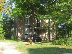 | Paine House | building | 1985 | 85002843 |
 | Shriver House | building | 1983 | 83000306 |
Every wildfire the federal occurrence database records inside this county: 38 of them, burning about 76 acres. None started naturally and 7 were recorded as arson. Each settlement page carries the fires within five miles of it.
| Reported cause | Fires |
|---|---|
| Debris and open burning | 17 |
| Missing data/not specified/undetermined | 11 |
| Arson/incendiarism | 7 |
| Smoking | 2 |
| Equipment and vehicle use | 1 |
The five largest, by the area the report gives. None of them was recorded as arson.
| Date | Cause | Size | Reported by | Name on the report |
|---|---|---|---|---|
| 3 March 2009 | Missing data/not specified/undetermined | 15 acres | Illinois Division of Forestry Resources | 27 |
| 3 March 2010 | Smoking | 10 acres | Illinois Division of Forestry Resources | CARTER |
| 1 November 2010 | Missing data/not specified/undetermined | 5.0 acres | Illinois Division of Forestry Resources | SMITH |
| 17 February 2013 | Debris and open burning | 5.0 acres | Illinois Division of Forestry Resources | 2710 |
| 10 December 2010 | Debris and open burning | 4.0 acres | Illinois Division of Forestry Resources | PIERSON |
| 13 October 2013 | Debris and open burning | 4.0 acres | Illinois Division of Forestry Resources | 17301 |
| 27 September 2013 | Debris and open burning | 3.0 acres | Illinois Division of Forestry Resources | 16311 |
| 15 October 2010 | Debris and open burning | 3.0 acres | Illinois Division of Forestry Resources | SCHNEPPER |
Every settlement page carries the fires within five miles of it - see the settlement index below.
The NOAA Storm Events Database holds 365 reports for this county, causing no deaths, 20 injuries and about $25,093,100 in recorded property damage. Each settlement page carries the reports that name it.
| Kind of event | Reports |
|---|---|
| Thunderstorm Wind | 193 |
| Hail | 81 |
| Flash Flood | 57 |
| Tornado | 21 |
| Flood | 8 |
| Lightning | 5 |
The most serious of them, by death, then injury, then recorded damage. The accounts are quoted exactly as the forecast office filed them.
| When | Event | Place named | Harm | What the report says |
|---|---|---|---|---|
| April 1998 | Tornado (F2) | Flora | 8 hurt, $2,100,000 | no account filed |
| April 2002 | Tornado (F1) | Flora | 5 hurt | A tornado touched down 2 miles southwest of Flora near the intersection of county road 1000E and 200N. At this location, it turned an unattached garage on its foundation. As the tornado travelled east along 200N it destroyed a mobile home. The three occupants sustained minor injuries. Debris from the mobile home was blown up to a mile away. It damaged 3 additional homes and a mobile home. Also, numerous trees were blown down and a propane tank was thrown a quarter of a mile. At the intersection of 1100E and 200N, a car was rolled three times and thrown into a ditch. Two occupants in the car had minor injuries, but refused treatment. As it continued east, the tornado destroyed an outbuilding. The last evidence of damage due to the tornado was located on county road 1500E, just north of 200N. Several powerlines and trees were blown over causing minor damage to a house and car. |
| June 2011 | Thunderstorm Wind | Flora | 3 hurt, $10,000 | A large tree limb was blown down onto a car along Route 50 west of Flora. 3 people inside the car were injured. |
| May 2004 | Thunderstorm Wind | Countywide | 3 hurt | Thunderstorm winds caused widespread damage throughout Clay County. However, the hardest hit areas were Flora and Clay City. The majority of the damage was to trees and power lines. Numerous structures sustained damage due to the trees falling on them. Also, several barns and grain bins were destroyed and a couple of mobile homes and trailers were flipped over. Three people sustained minor injuries. |
| July 2016 | Thunderstorm Wind | Ingraham | 1 hurt, $100,000 | A mobile home was blown over and destroyed, injuring one person inside. A grain bin was blown 200 feet. |
| May 2024 | Tornado (EF2) | Oskaloosa | $10,000,000 | This tornado originally touched down in Marion County in the National Weather Service Saint Louis County Warning Area (CWA), then crossed into southwestern Clay County just north of the intersection of Beard Road and Songer Township Lane at 7:35 PM CDT. It knocked down several trees and power lines before tracking northeastward and doing its greatest damage at a farm on the north end of Penguin Drive where several large metal buildings were demolished. The tornado then lifted just east of Xenia-Iola Road between Songer Township Lane and Hickory Hill Lane at 7:43 PM CDT. |
| June 2013 | Flash Flood | Cruse | $9,000,000 | Numerous thunderstorms produced 3 to 6 inches of rain on already saturated ground in nearly all of Clay County. Major flash flooding was reported in the town of Xenia and the city of Flora, where several people were evacuated from their flooded homes. Several water rescues were made for stranded motorists in and near Flora. In the northwest part of the county from Iola to Hord all roads were closed, including U.S. Highway 45. |
| May 2011 | Tornado (EF1) | Clay City | $510,000 | A tornado developed about 1 mile southwest of Clay City. The tornado tracked northeast and dissipated near Clay City High School. Structures damaged along the path of the tornado included a barn and several garages, and 15 homes sustained minor to moderate roof damage. One concrete block storage building collapsed. Numerous trees were also damaged. |
| April 1994 | Thunderstorm Wind | Louisville | $500,000 | Two barns were destroyed by thunderstorm wind 6 miles north of Louisville. Large trees were blown down in Louisville. |
| June 1990 | Tornado (F4) | not stated | $250,000 | no account filed |
| December 1957 | Tornado (F3) | not stated | $250,000 | no account filed |
| May 2018 | Thunderstorm Wind | Flora | $175,000 | Numerous trees and power lines were blown down around Flora. Some large trees fell onto houses. |
| August 2007 | Thunderstorm Wind | Hord | $170,000 | A swath of damaging winds went through the town of Hord. 26 homes received minor damage. 20 outbuildings were damaged and 6 were destroyed. 2 businesses had minor damage. 10 utility poles were destroyed. Numerous trees and tree limbs were blown down and several corn fields were flattened. |
| July 2016 | Thunderstorm Wind | Louisville | $110,000 | Several houses sustained wind damage to their roofs near the high school in Louisville. |
| May 2013 | Lightning | Ingraham | $100,000 | Ten oil tank batteries were ignited by a lightning strike west of Ingraham. |
| May 1995 | Thunderstorm Wind | Countywide | $100,000 | Numerous trees were blown down across the county. |
| April 1998 | Tornado (F2) | Clay City | $100,000 | no account filed |
| June 2008 | Thunderstorm Wind | Flora | $80,000 | Numerous trees, tree limbs, and power lines were blown down in and around Flora. One falling tree caused severe damage to a pickup truck. Several mobile homes had skirting and siding blown off. |
| April 2016 | Thunderstorm Wind | Flora | $70,000 | Several trees and tree branches were blown down in Flora, knocking out power to half the town. One house was severely damaged by a falling tree. |
| July 2016 | Thunderstorm Wind | Iola | $70,000 | Numerous trees, tree branches, and power lines were blown down in Iola and Xenia. |
| July 2016 | Thunderstorm Wind | Clay City | $60,000 | Numerous trees, tree branches, and power lines were blown down in Clay City. |
| October 2010 | Thunderstorm Wind | Flora | $55,000 | Numerous trees were blown down in Flora. Two of the trees fell on houses and another hit a parked vehicle. A grain trailer was blown 100 yards away from the Cargill building, and the siding was ripped off a garage. |
| June 2008 | Thunderstorm Wind | Xenia | $55,000 | Numerous trees and tree limbs were blown down. 5 homes sustained minor damage from falling trees and tree limbs. One home had some of its windows blown in from the high winds. |
| July 2009 | Flash Flood | Xenia | $50,000 | Nearly 2.50 inches of rain in one hour created flash flooding in southern Clay County. Popeberry Lane near Fairfield Road, 1.5 miles south of Xenia, was washed out due to the flooding. Several rural roads near Flora and Clay City had water flowing across them. |
| May 2021 | Tornado (EF0) | Sailor Spgs | $45,000 | A tornado touched down 1.8 miles southeast of Sailor Springs at 3:43 PM CDT. The tornado tracked southeastward and knocked down a few trees and did minor damage to a barn before dissipating at 3:49 PM CDT about 4.6 miles southeast of Sailor Springs. |
| May 2018 | Thunderstorm Wind | Louisville | $45,000 | Numerous small trees were blown down and a barn was severely damaged. |
| May 2016 | Thunderstorm Wind | Flora | $40,000 | Several large tree branches and power lines were blown down in Flora. Shingles were blown off a roof on Austin Avenue. |
| April 2017 | Thunderstorm Wind | Clay City | $35,000 | A tree was blown down onto a trailer. |
| July 2016 | Thunderstorm Wind | Flora | $35,000 | Several trees were blown down in Flora. |
| January 2008 | Thunderstorm Wind | Xenia | $35,000 | A 61 MPH wind gust was measured at the Flora Airport. Numerous trees, tree limbs, and power lines were blown down between Xenia and Sailor Springs, including the Flora area. In addition, siding was torn off mobile homes in Flora and a semi was blown over near Sailor Springs. |
| May 2018 | Thunderstorm Wind | Xenia | $30,000 | Multiple trees were blown down in Xenia. |
| April 2016 | Lightning | Xenia | $30,000 | Lightning struck a garage in Xenia. The resulting fire completely destroyed the garage. |
| December 2015 | Thunderstorm Wind | Xenia | $30,000 | A 40 by 80-foot barn was damaged on Butternut Road about 4 miles north of Xenia. The barn doors were blown in on the south side, the east wall was bowed out, and the roof was partially torn off. |
| August 2014 | Thunderstorm Wind | Clay City | $30,000 | Numerous trees and tree branches were blown down in Clay City. |
| June 2013 | Thunderstorm Wind | Flora | $30,000 | Twenty-five to thirty feet of hangar roof was blown off the Flora Airport and blocked the road on the west side of the airport. |
| May 2011 | Thunderstorm Wind | Flora | $30,000 | Numerous 6-inch diameter tree branches and powerlines were blown down on the northeast side of Flora. |
| June 2018 | Thunderstorm Wind | Wendelin | $25,000 | A pole barn was severely damaged on Silver Lane just west of Beryl Road. |
| July 2016 | Thunderstorm Wind | Flora | $25,000 | A large pole barn had half its roof blown off. |
| August 2014 | Thunderstorm Wind | Xenia | $25,000 | Numerous trees and tree branches were blown down in Xenia. |
| March 2012 | Thunderstorm Wind | Xenia | $25,000 | Numerous trees were blown down about 2 miles southeast of Xenia. |
| October 2010 | Thunderstorm Wind | Sailor Spgs | $25,000 | An 18-inch diameter tree was blown onto a trailer. |
| March 1961 | Tornado (F1) | not stated | $25,000 | no account filed |
| May 1960 | Tornado (F1) | not stated | $25,000 | no account filed |
| July 2010 | Thunderstorm Wind | Flora | $24,000 | Several 10-inch diameter tree branches were blown down in Flora. |
| May 2021 | Thunderstorm Wind | Clay City | $21,000 | A tree was blown onto a car. |
| May 2016 | Thunderstorm Wind | Louisville | $20,000 | Large tree limbs were blown down on the southwest side of Louisville. |
| June 2015 | Flash Flood | Hoosier | $20,000 | Thunderstorms produced 3.00 to 5.00 of rainfall in a large part of Clay County, mainly between 0000 and 0300 local standard time. Flash flooding rapidly developed, which made many rural roads impassable from Iola to Louisville. U.S. Highway 45 near Louisville was also flooded, and was closed after floodwaters swept a car off the highway. The driver was rescued and no injuries were reported. |
| August 2014 | Thunderstorm Wind | Flora | $20,000 | Several large tree branches were blown down in Flora, including one that landed on a house. |
| August 2013 | Lightning | Flora | $20,000 | Lightning struck a garage on East 9th Street in Flora. The resulting fire caused significant damage to the garage. |
| August 2012 | Thunderstorm Wind | Clay City | $20,000 | The roof of a building was blown off at the corner of 5th and Walnut Street in Clay City. The roof of a trailer was also blown off, and a tree was knocked down onto a house. |
| April 2011 | Thunderstorm Wind | Flora | $20,000 | Several trees were blown down. |
| April 2011 | Thunderstorm Wind | Xenia | $20,000 | Several trees were blown down. |
| June 2010 | Thunderstorm Wind | Flora | $20,000 | Several trees and power lines were blown down in Flora. |
| March 2009 | Tornado (EF0) | Camp Travis | $20,000 | The tornado initially touched down in the National Weather Service Paducah County Warning Area (CWA) in Wayne County at 11:58 AM CST. It then tracked northeastward and crossed into southern Clay County at 12:03 PM CST. The tornado quickly dissipated by 12:04 PM CST 7.3 miles southeast of Clay City. One home experienced minor damage and numerous trees were blown down. |
| February 2008 | Thunderstorm Wind | Xenia | $20,000 | Numerous trees and power lines were blown down. |
| August 2012 | Thunderstorm Wind | Clay City | $18,000 | Several trees and tree limbs were blown down. Power lines were also knocked down. |
| June 2019 | Thunderstorm Wind | Xenia | $15,000 | A tree was blown onto a house in Xenia. |
| June 2013 | Thunderstorm Wind | Louisville | $15,000 | A tree was blown down onto a vehicle in Louisville. |
| February 2011 | Thunderstorm Wind | Flora | $15,000 | Five power poles were snapped along U.S. 45 north of Flora. |
| July 2009 | Thunderstorm Wind | Xenia | $15,000 | Numerous 6-inch diameter tree limbs were blown down. |
The Survey's mineral resources record lists 8 workings inside this county. 1 still produces and 7 are closed or unrecorded. Each settlement page carries the workings within five miles of it.
| Commodity | Workings |
|---|---|
| Stone, Crushed/Broken | 7 |
| Clay | 1 |
The least common of them first, because a county's hundredth gravel pit says nothing its first ten did not.
| Where | Site | Commodity | Status | Recorded |
|---|---|---|---|---|
| Speaks Clay Exposure Shale | Clay | Prospect | ||
| Clay Cty Hwy Dept | Stone, Crushed/Broken | Past Producer | ||
| Iola Quarry | Stone, Crushed/Broken | Producer | ||
| Limestone Prospect | Stone, Crushed/Broken | Occurrence | ||
| Limestone Prospect | Stone, Crushed/Broken | Occurrence | ||
| Limestone Prospect | Stone, Crushed/Broken | Occurrence | ||
| Louisville City Eng | Stone, Crushed/Broken | Past Producer | ||
| Shoots Stone Quarry No. 2 | Stone, Crushed/Broken | Past Producer |
Named settlements recorded in the Geographic Names Information System, each with the topographic sheets covering it. Villages, hamlets and abandoned places alike. Each is shown with the nearest named watercourse or landform and the survey quadrangle it falls on.
Songer township · 62899 · On Sutton Creek · Xenia quadrangle
10 sheets, 1952 to 1986
No longer a settlement
Pixley township · 62434 · Near Indian Point · Sailor Springs quadrangle
9 sheets, 1953 to 1986
Louisville township · 62858 · On Panther Creek · Louisville West quadrangle
9 sheets, 1956 to 1986
Louisville township · 62858 · On Dismal Creek · Louisville West quadrangle
9 sheets, 1956 to 1986
Hoosier township · 62824 · On Spring Branch · Sailor Springs quadrangle
9 sheets, 1953 to 1986
Pixley township · 62868 · On East Fork Wetweather Creek · Sailor Springs quadrangle
9 sheets, 1953 to 1986
The vanished settlements of Clay County: the places named above that are no longer on the map.