 Block
From the record
3 National Register listings published here.
Sources: the National Register database, National Park Service
37 topographic sheets cover 19 settlements here, and 3 properties are on the National Register of Historic Places.
3 National Register listings published here.
Sources: the National Register database, National Park Service
Every property in this county listed on the National Register of Historic Places, with the year it was listed and the federal nomination document.
| Photograph | Property | Type | Listed | Reference |
|---|---|---|---|---|
 | Cumberland County Courthouse | building | 1981 | 81000220 |
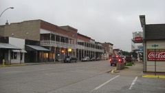 | Greenup Commercial Historic District | district | 1991 | 91000083 |
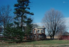 | Thornton Ward Estate | building | 2001 | 01001308 |
Every wildfire the federal occurrence database records inside this county: 13 of them, burning about 6 acres. None started naturally and none was recorded as arson. Each settlement page carries the fires within five miles of it.
| Reported cause | Fires |
|---|---|
| Missing data/not specified/undetermined | 13 |
The five largest, by the area the report gives. None of them was recorded as arson.
| Date | Cause | Size | Reported by | Name on the report |
|---|---|---|---|---|
| 21 October 2010 | Missing data/not specified/undetermined | 2.0 acres | Illinois Division of Forestry Resources | 1089 |
| 23 March 2010 | Missing data/not specified/undetermined | 1.0 acres | Illinois Division of Forestry Resources | 1019 |
| 31 March 2011 | Missing data/not specified/undetermined | 1.0 acres | Illinois Division of Forestry Resources | 1116 |
| 26 December 2018 | Missing data/not specified/undetermined | under an acre | Illinois Division of Forestry Resources | 2018-2931 |
| 16 October 2010 | Missing data/not specified/undetermined | under an acre | Illinois Division of Forestry Resources | 1086 |
| 18 October 2010 | Missing data/not specified/undetermined | under an acre | Illinois Division of Forestry Resources | 1087 |
| 21 April 2010 | Missing data/not specified/undetermined | under an acre | Illinois Division of Forestry Resources | 1024 |
| 7 October 2010 | Missing data/not specified/undetermined | under an acre | Illinois Division of Forestry Resources | 1080 |
Every settlement page carries the fires within five miles of it - see the settlement index below.
The NOAA Storm Events Database holds 180 reports for this county, causing no deaths, 7 injuries and about $1,552,700 in recorded property damage. Each settlement page carries the reports that name it.
| Kind of event | Reports |
|---|---|
| Thunderstorm Wind | 87 |
| Hail | 39 |
| Flash Flood | 29 |
| Tornado | 18 |
| Flood | 7 |
The most serious of them, by death, then injury, then recorded damage. The accounts are quoted exactly as the forecast office filed them.
| When | Event | Place named | Harm | What the report says |
|---|---|---|---|---|
| April 1984 | Tornado (F1) | not stated | 2 hurt, $250,000 | no account filed |
| March 2025 | Tornado (EF2) | Neoga | 2 hurt | An EF-2 tornado began on the southeast side of Neoga, tracking through Cumberland County for 5.2 miles before continuing into Coles County for an additional 7.7 miles, where it also produced EF-2 damage. The tornado began south of county road 1000N, then moved into the southeast side of Neoga where it damaged the roof of a home, the roof of the high school, and caved in the front door of the elementary school. From there, it moved northeast and damaged a grain bin near the US Route 45 and I-57 intersection. Two injuries occurred to semi-truck drivers as their vehicles were overturned on I-57 at the US-45 exit. As the tornado continued northeast, additional damage occurred to trees, power poles, and farm outbuildings. Just south of the Cumberland-Coles County line, the tornado produced EF-2 damage to a home where large sections of the roof structure were removed. The tornado crossed into Coles County just over a half mile west of US Route 45. |
| June 2024 | Thunderstorm Wind | Toledo | 1 hurt | A tree was blown down onto a car resulting in an injury to one person. |
| June 1998 | Thunderstorm Wind | Neoga | 1 hurt | Thunderstorm winds blew over a semi on I-57 near Neoga. The driver was ok, while his passenger sustained minor injuries. |
| October 1996 | Tornado (F0) | Neoga | 1 hurt | no account filed |
| October 2000 | Flash Flood | Countywide | $300,000 | no account filed |
| May 2014 | Hail | Greenup | $200,000 | The hail caused roof, siding, and vehicle damage. |
| June 2008 | Flood | Lake Mattoon | $100,000 | Rainfall amounts of 5 to 7 inches between June 4th and the 6th produced extensive flooding in Cumberland County, particularly in rural areas north and east of Greenup. Numerous county roads were under water between June 7th and the 13th. Cumberland County was declared a disaster area due to the flooding. |
| June 2009 | Thunderstorm Wind | Neoga | $60,000 | Numerous trees and power lines were blown down. A shed was blown apart and siding was torn off a house. |
| August 2012 | Thunderstorm Wind | Neoga | $50,000 | Numerous trees and tree branches were blown down across Cumberland County. Large branches were knocked down onto 3 houses in Janesville. Power lines were blown down, resulting in a power outage in Greenup. |
| June 2008 | Thunderstorm Wind | Neoga | $50,000 | Numerous trees and power lines were blown down. In addition, a semi trailer was blown over on Interstate 57. |
| April 1999 | Tornado (F0) | Janesville | $50,000 | no account filed |
| May 2009 | Thunderstorm Wind | Neoga | $40,000 | Several semi-trailers were blown off of I-57 at milepost 179. |
| June 2008 | Flash Flood | Toledo | $40,000 | Multiple roads closed due to high water flowing over them, including IL Route 121 near Greenup. Two mudslides occurred north of Greenup. A vehicle was found submerged at the Cumberland County Fairgrounds. At least 2 bridges and multiple roads suffered damage from the flooding in Greenup. |
| April 2015 | Thunderstorm Wind | Neoga | $35,000 | A small shed was destroyed, a few trees were snapped, and numerous large tree branches were blown down in Neoga. |
| April 2010 | Thunderstorm Wind | Toledo | $30,000 | A downburst caused minor wind damage on the southwest side of Toledo. A wood fence and travel trailer were blown over. In addition, several small limbs were blown down and 3 houses lost shingles. |
| June 2010 | Thunderstorm Wind | Neoga | $30,000 | An oak tree split in half and fell on a house. Numerous tree brances were blown down around town. |
| July 2016 | Thunderstorm Wind | Neoga | $25,000 | Large tree limbs were blown onto a truck in Neoga. |
| April 2015 | Thunderstorm Wind | Toledo | $25,000 | Several large tree branches were blown down in Toledo. |
| June 2011 | Thunderstorm Wind | Jewett | $25,000 | Numerous tree limbs and power lines were blown down in Jewett. |
| August 2007 | Thunderstorm Wind | Neoga | $25,000 | Numerous trees, tree limbs and power lines were blown down between Neoga, Toledo, and Greenup. |
| August 1977 | Tornado (F3) | not stated | $25,000 | no account filed |
| July 2016 | Thunderstorm Wind | Neoga | $20,000 | Power lines were blown down in Neoga. |
| July 2013 | Thunderstorm Wind | Jewett | $20,000 | Several trees and tree branches were blown down in Jewett. |
| February 2008 | Thunderstorm Wind | Toledo | $20,000 | Numerous trees and power lines were blown down. |
| August 2009 | Thunderstorm Wind | Greenup | $18,000 | Numerous trees and tree limbs were blown down in Greenup. |
| May 2013 | Thunderstorm Wind | Neoga | $16,000 | Several large tree branches were blown down and a flag pole was bent. |
| June 2011 | Thunderstorm Wind | Neoga | $15,000 | Several large tree limbs were blown down in Neoga. |
| August 2009 | Thunderstorm Wind | Neoga | $15,000 | Numerous trees and power lines were blown down in Neoga. |
| August 2009 | Thunderstorm Wind | Neoga | $15,000 | A roof was damaged by high winds at Camp New Hope. |
| August 2013 | Thunderstorm Wind | Toledo | $8,000 | A few trees were blown down in Toledo. |
| June 2008 | Thunderstorm Wind | Toledo | $8,000 | A large tree was blown down onto a house. |
| April 2017 | Thunderstorm Wind | Toledo | $7,000 | A power pole was snapped. |
| April 2017 | Thunderstorm Wind | Toledo | $7,000 | A power pole was snapped. |
| October 2010 | Thunderstorm Wind | Greenup | $5,000 | A large tree was blown down onto powerlines south of Greenup. |
| April 1997 | Thunderstorm Wind | Janesville | $4,200 | Thunderstorm winds damaged a house when a tree fell onto it and blew over a shed in Janesville. Also, a walnut tree was uprooted breaking 3 windows of a van parked nearby and the winds moved a bass boat about 150 yards. Damage was estimated around $4,200 and no injuries were reported. |
| July 2009 | Thunderstorm Wind | Neoga | $3,000 | A downburst associated with a strong thunderstorm tore the top out of a tree at a residence in Neoga. |
| June 1963 | Tornado (F1) | not stated | $2,500 | no account filed |
| March 1961 | Tornado (F1) | not stated | $2,500 | no account filed |
| February 1960 | Tornado (F1) | not stated | $2,500 | no account filed |
| May 2013 | Thunderstorm Wind | Greenup | $2,000 | A large walnut tree was blown down. |
| June 2010 | Thunderstorm Wind | Neoga | $2,000 | Two railroad crossing arms were blown off. |
| March 2025 | Thunderstorm Wind | Janesville | - | Large tree branches were broken and a small outbuilding was shifted slightly on its foundation. |
| March 2025 | Thunderstorm Wind | Neoga | - | The north wall of a farm building collapsed, resulting in roof failure. The building was open on the south side, through which the winds surged and led to the wall collapse. |
| April 2025 | Tornado (EF0) | Woodbury | - | A tornado touched down southwest of the point where County Road 900 East crosses Webster Branch about 1 mile south of Woodbury at 6:29 PM CDT. It tracked northeastward just south of US-40 and impacted the community of Jewett where it damaged several roofs and snapped numerous trees and tree branches. The tornado dissipated on the east side of Jewett at 6:33 PM CDT. |
| April 2025 | Tornado (EF2) | Jewett | - | A tornado touched down southwest of the intersection of County Road 1225 East and County Road 450 North about 2.5 miles south of Toledo at 6:33 PM CDT. The tornado tracked northeastward, knocking down trees and damaging outbuildings before increasing in intensity and snapping nearly two dozen power poles and destroying an outbuilding south and east of Union Center. It then crossed into Clark County south of the intersection of County Road 000 East and County Road 1530 North at 6:48 PM CDT. |
| April 2025 | Thunderstorm Wind | Greenup | - | Several trees were snapped or blown down in Greenup. |
| April 2025 | Thunderstorm Wind | Toledo | - | A fence and several tree limbs were blown down. A couple mature pine trees were snapped in half. |
| April 2025 | Thunderstorm Wind | Greenup | - | A couple small outbuildings were damaged and several large tree branches were blown down. |
| July 2025 | Thunderstorm Wind | Greenup | - | A large tree limb was blown onto power lines. |
| July 2024 | Thunderstorm Wind | Toledo | - | A powerline was blown down. |
| June 2024 | Thunderstorm Wind | Toledo | - | Several large tree branches were blown down. |
| August 2023 | Thunderstorm Wind | Neoga | - | A power pole was blown down and caught on fire. |
| August 2023 | Thunderstorm Wind | Toledo | - | Several tree branches were blown down. |
| August 2023 | Thunderstorm Wind | Neoga | - | Downburst winds of 80-85 mph caused significant damage around Lake Mattoon. Extensive tree damage was noted in a concentrated area south of Cumberland County Road 1250 North. |
| March 2023 | Thunderstorm Wind | Neoga | - | A large tree was snapped at the base. |
| June 2023 | Thunderstorm Wind | Lake Mattoon | - | Several trees and tree branches were blown down. |
| June 2023 | Thunderstorm Wind | Neoga | - | Extensive tree damage occurred across Neoga, with some trees down on houses with residents trapped inside. |
| August 2022 | Flash Flood | Neoga | - | Several roadways were flooded in Neoga. |
| August 2022 | Flash Flood | Lake Mattoon | - | Water was flowing across the road in spots along Route 121 between Toledo and Mattoon. |
The Survey's mineral resources record lists 10 workings inside this county. 3 still produce and 7 are closed or unrecorded. Each settlement page carries the workings within five miles of it.
| Commodity | Workings |
|---|---|
| Sand and Gravel, Construction | 5 |
| Clay | 2 |
| Stone | 2 |
| Stone, Crushed/Broken | 1 |
The least common of them first, because a county's hundredth gravel pit says nothing its first ten did not.
| Where | Site | Commodity | Status | Recorded |
|---|---|---|---|---|
| Limestone Prospect | Stone, Crushed/Broken | Occurrence | ||
| Cumberland City Pit | Stone | Past Producer | ||
| Greenup Shale Exposure | Clay | Prospect | ||
| Oak Chapel Shale Pit | Clay | Past Producer | ||
| Toledo City Pit | Stone | Past Producer | ||
| C&H Gravel East Dredge | Sand and Gravel, Construction | Producer | ||
| C&H Gravel Pit #1 | Sand and Gravel, Construction | Past Producer | ||
| C&H Gravel Pit #2 | Sand and Gravel, Construction | Producer | ||
| East Pit | Sand and Gravel, Construction | Past Producer | ||
| Greenup Sand & Gravel | Sand and Gravel, Construction | Producer |
Named settlements recorded in the Geographic Names Information System, each with the topographic sheets covering it. Villages, hamlets and abandoned places alike. Each is shown with the nearest named watercourse or landform and the survey quadrangle it falls on.
Cottonwood township · 62440 · On Dicks Creek · Johnstown quadrangle
14 sheets, 1934 to 1998
Union township · 62428 · On Opossum Creek · Union Center quadrangle
12 sheets, 1933 to 1998
Union township · 62420 · On Birch Creek · Union Center quadrangle
12 sheets, 1933 to 1998