 Block
From the record
1 National Register listing published here.
Sources: the National Register database, National Park Service
44 topographic sheets cover 15 settlements here, and 1 property is on the National Register of Historic Places.
1 National Register listing published here.
Sources: the National Register database, National Park Service
Every property in this county listed on the National Register of Historic Places, with the year it was listed and the federal nomination document.
| Photograph | Property | Type | Listed | Reference |
|---|---|---|---|---|
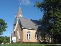 | St. Johns Episcopal Church | building | 2012 | 12000027 |
Every wildfire the federal occurrence database records inside this county: 12 of them, burning about 15 acres. None started naturally and none was recorded as arson. Each settlement page carries the fires within five miles of it.
| Reported cause | Fires |
|---|---|
| Debris and open burning | 8 |
| Missing data/not specified/undetermined | 3 |
| Equipment and vehicle use | 1 |
The five largest, by the area the report gives. None of them was recorded as arson.
| Date | Cause | Size | Reported by | Name on the report |
|---|---|---|---|---|
| 22 March 2018 | Debris and open burning | 4.0 acres | Illinois Division of Forestry Resources | 296 |
| 16 March 2018 | Missing data/not specified/undetermined | 2.0 acres | Illinois Division of Forestry Resources | 294 |
| 12 March 2017 | Debris and open burning | 1.0 acres | Illinois Division of Forestry Resources | 225 |
| 8 September 2015 | Missing data/not specified/undetermined | 1.0 acres | Illinois Division of Forestry Resources | 15-132 |
| 6 February 2016 | Debris and open burning | 1.0 acres | Illinois Division of Forestry Resources | 154 |
| 25 April 2017 | Debris and open burning | 1.0 acres | Illinois Division of Forestry Resources | 231 |
| 22 September 2019 | Debris and open burning | 1.0 acres | Illinois Division of Forestry Resources | 419 |
| 22 May 2017 | Equipment and vehicle use | 1.0 acres | Illinois Division of Forestry Resources | 237 |
Every settlement page carries the fires within five miles of it - see the settlement index below.
The NOAA Storm Events Database holds 149 reports for this county, causing 3 deaths, 4 injuries and about $8,706,000 in recorded property damage. Each settlement page carries the reports that name it.
| Kind of event | Reports |
|---|---|
| Thunderstorm Wind | 58 |
| Hail | 37 |
| Flash Flood | 16 |
| Heavy Rain | 12 |
| Flood | 11 |
| Tornado | 10 |
| Lightning | 4 |
| Funnel Cloud | 1 |
The most serious of them, by death, then injury, then recorded damage. The accounts are quoted exactly as the forecast office filed them.
| When | Event | Place named | Harm | What the report says |
|---|---|---|---|---|
| May 1995 | Thunderstorm Wind | Countywide | 2 killed, $200,000 | Two fatalities occurred when straight-line winds overturned a tractor-semitrailer into the path of an oncoming automobile. Both drivers were killed instantly. Numerous trees were blown down across the county with widespread power outages. |
| June 1990 | Tornado (F4) | not stated | 1 killed, $2,500,000 | no account filed |
| July 2012 | Thunderstorm Wind | West Salem | 2 hurt, $25,000 | Twelve power poles were knocked down. |
| June 1998 | Thunderstorm Wind | Albion | 1 hurt, $50,000 | One mobile home was demolished and numerous trees were blown down in and around Albion. One occupant of the mobile home received cuts and bruises after the mobile home rolled over twice and came to rest about 50 feet from its original location. On the White County line, just north of Grayville, a wind gust to 69 MPH was clocked. Numerous streets were blocked by downed trees and limbs. |
| July 1958 | Tornado (F2) | not stated | 1 hurt, $25,000 | no account filed |
| January 1989 | Tornado (F2) | not stated | $2,500,000 | no account filed |
| April 2011 | Thunderstorm Wind | Blood | $1,000,000 | Widespread major damage occurred across the county. An insurance agent reported over 450 claims to his office alone. The 100-foot tall steeple of an old historic church in West Salem was toppled. The steeple punctured a hole in the roof as it fell. A house in West Salem suffered major damage when a large oak tree fell on it. West Salem firefighters worked through the following day to clear streets of downed trees. Elsewhere in northern Edwards County, a house was partially unroofed. Trees were uprooted, and power lines were down. Numerous grain bins, machine sheds, and outbuildings were damaged or destroyed. |
| May 1996 | Hail | Albion | $500,000 | no account filed |
| April 1972 | Tornado (F1) | not stated | $250,000 | no account filed |
| November 2013 | Tornado (EF2) | Black | $200,000 | The tornado crossed into Edwards County from Wayne County. Numerous trees were snapped or uprooted. A new addition to a house was destroyed. An attached garage was destroyed, with two vehicles turned 180 degrees. Two 100-year-old barns were totally destroyed. Several 100-year-old trees were snapped or uprooted. Other residences in the area sustained minor damage. The estimated peak winds in this tornado were 130 mph. The maximum intensity was attained just west of Illinois Route 130, almost due north of Albion. A second shorter track EF-2 tornado occurred simultaneously just south of this tornado. Both tornadoes were witnessed on the ground at the same time. This tornado was spawned by the same supercell that produced the EF-2 tornado that tracked from Sims to Fairfield in Wayne County. |
| October 2001 | Thunderstorm Wind | Countywide | $200,000 | A line of thunderstorms produced damaging winds countywide. The most severe damage appeared to be in southern parts of the county, between Grayville and Albion. Just northwest of Grayville, a residence was partially unroofed, the front porch was blown away, and a nearby shed was destroyed. At a nearby farm, another shed was destroyed, and a pickup truck was blown over. At a farm southwest of Albion, a grain bin was blown into a pond, and an equipment barn was destroyed. Power poles were broken 1 mile south of Browns and near the Richland County line. Along Illinois Route 130, about 10 utility poles were blown down, blocking the highway at the Richland County line. In West Salem, several large branches landed on roofs, and TV antennas and chimneys were damaged. Near Browns, a 60 by 72 foot storage building and its contents were heavily damaged. Other structures were damaged south of Browns. |
| November 2013 | Tornado (EF2) | Black | $150,000 | This tornado travelled just south of and nearly parallel to another EF-2 tornado. Two machine sheds were destroyed along with a barn. Several trees were snapped. More than one eyewitness saw both tornadoes on the ground at the same time. Peak winds were estimated near 110 mph. This tornado was spawned by the same supercell that produced the EF-2 tornado that tracked from Sims to Fairfield in Wayne County. |
| April 2006 | Thunderstorm Wind | Countywide | $150,000 | A 157-year-old wooden church in Samsville suffered severe wind damage. Much of the structure collapsed, while a few exterior walls remained partially standing. Most of the interior contents were destroyed, except for those in the basement. Elsewhere to the north of Albion, a large machine shed, several other sheds, and barns were heavily damaged or destroyed. At least two vehicles and a trailer were demolished by a large tree north of Albion. Widespread damage to trees and power lines occurred in the northern half of the county. A house trailer was split in half by a downed tree. Around eight power poles, along with some power lines, were down across Route 130 from West Salem northward to the county line. About eight miles south-southwest of Albion, the roof was peeled off a mobile home and blown into a pond. A dog alone in the mobile home survived, but the mobile home was uninhabitable. |
| May 1999 | Thunderstorm Wind | Albion | $100,000 | Several buildings were damaged, and numerous trees and power lines were down. At least a couple of trees landed on homes and vehicles. One tree blocked Route 15 temporarily. An office building was damaged when its brick chimney blew over and fell through the roof. At least a couple of buildings received broken windows. Another building sustained minor roof damage. The damage appeared to be greatest over northern parts of the city. |
| July 2017 | Thunderstorm Wind | West Salem | $85,000 | Scattered straight-line wind damage was observed across much of the northern half of the county. Within the overall area of scattered damage, more concentrated damage was located in West Salem. In West Salem, numerous large tree limbs were broken, and a couple of trees were uprooted. Elsewhere around northern Edwards County, hundreds of tree limbs and about a half-dozen trees were blown down. Downed trees and limbs damaged a couple of homes, garages, and a pickup truck. Two barns were blown down between West Salem and Bone Gap. Several power poles were blown over. Peak winds were estimated near 80 mph. The damaging wind event continued east into Wabash County. |
| July 2014 | Thunderstorm Wind | Albion | $60,000 | Numerous trees were blown down in Albion. At least eight trees were blown down on the south side of Albion. The trees ranged from one to three feet in diameter. One tree fell in a pool. Power lines were blown down. A very large tree fell into a home, producing significant damage. Another tree landed on a car. |
| July 2011 | Lightning | Albion | $50,000 | A lightning strike took out phone lines, radio consoles, and alarm systems at the county courthouse. The lightning appeared to have surged through the phone lines into the building. |
| July 2011 | Flash Flood | Albion | $50,000 | Illinois Routes 15 and 130 were flooded in the Albion area. Many rural county roads suffered from washouts, especially gravel roads and culverts. A trained spotter in Albion reported a 24-hour rainfall total of 2.78 inches. |
| August 2006 | Thunderstorm Wind | Countywide | $50,000 | Trees and power lines were blown down countywide. The community of West Salem received the brunt of the storm, where roofs were blown off two structures, and a number of other homes were damaged by falling trees. A snapped telephone pole resulted in a 90-minute power outage for much of West Salem. In Browns, a heavy iron chair was blown off a porch and into a car. Several limbs were down. |
| April 1996 | Flash Flood | Albion | $50,000 | no account filed |
| May 2011 | Thunderstorm Wind | Albion | $40,000 | Trees were blown down. One tree landed on a mobile home just south of the city. |
| January 2012 | Tornado (EF1) | Albion | $30,000 | The tornado produced mainly tree damage. One steel high tension power pole was damaged. The average path width was 50 yards. Peak winds were estimated near 100 mph. |
| June 1999 | Lightning | Browns | $30,000 | Lightning struck a large oil storage tank, causing a spectacular fire. |
| May 2011 | Flood | Albion | $30,000 | no account filed |
| June 2022 | Thunderstorm Wind | Albion | $25,000 | Lots of tree damage was reported. A tree fell on a home. |
| May 2019 | Thunderstorm Wind | Albion | $25,000 | A trained spotter reported a swath of downed trees and power lines near County Road 400. |
| May 2004 | Flash Flood | Samsville | $25,000 | no account filed |
| April 1989 | Tornado (F1) | not stated | $25,000 | no account filed |
| August 2025 | Thunderstorm Wind | Browns | $20,000 | Thunderstorm winds blew down numerous trees and large tree limbs in Grayville. Some of the downed trees took down powerlines. A brick wall of a business was partially knocked down. |
| May 2019 | Flash Flood | Albion | $20,000 | Several miles southwest of Albion, flash flooding of County Road 400 East occurred near the intersection of County Road 400 North. Parts of the road were washed away. A trained spotter measured a storm total of 5 inches of rain through the mid-morning hours. Near Browns, Illinois Highway 15 was flooded by Bonpas Creek. |
| June 2010 | Thunderstorm Wind | Albion | $20,000 | Tree limbs and utility lines were down around the county. |
| August 2007 | Thunderstorm Wind | Albion | $20,000 | Numerous large tree limbs and a few large trees were blown down. Some of the tree limbs severed power lines. At least five utility poles were snapped. |
| April 2002 | Thunderstorm Wind | Albion | $20,000 | Thunderstorm winds downed numerous trees, and several houses were damaged. A home in southwest Edwards County was damaged when a very large tree was uprooted and fell on the house. |
| May 2002 | Flash Flood | Countywide | $20,000 | no account filed |
| January 2008 | Thunderstorm Wind | Browns | $15,000 | A semi was blown into another semi, blocking Illinois Route 1. |
| July 1996 | Thunderstorm Wind | Albion | $15,000 | no account filed |
| March 2024 | Thunderstorm Wind | West Salem | $10,000 | A brick building on the town square had part of an exterior wall collapse due to downburst winds. |
| July 2023 | Thunderstorm Wind | Albion | $10,000 | Trees and power lines were down. |
| May 2011 | Lightning | West Salem | $10,000 | Lightning struck an oil tank battery, causing them to explode. |
| March 2008 | Flood | Albion | $10,000 | Some county roads were closed due to flooding. |
| April 1998 | Flash Flood | Countywide | $10,000 | Thunderstorms with very heavy rain flooded numerous roads, including Route 130. |
| July 2017 | Thunderstorm Wind | Albion | $8,000 | Numerous tree limbs up to three inches in diameter were blown down. |
| January 2012 | Thunderstorm Wind | Ellery | $6,000 | Trees were snapped and blown down. These straight-line winds occurred with the same storm that produced the EF-2 tornado near Enfield and Centerville in White County and the EF-1 tornado near Albion. |
| July 2010 | Thunderstorm Wind | Albion | $6,000 | Large tree limbs were blown down. One of them landed on a power line. |
| July 2023 | Thunderstorm Wind | Albion | $5,000 | Large trees and limbs were down. |
| August 2019 | Thunderstorm Wind | Albion | $5,000 | Several miles south-southwest of Albion, multiple small trees were down a half mile south of County Roads 400E and 400N. Just southwest of Albion, a two to three foot diameter tree was down at the corner of County Roads 400E and 725N. Lots of smaller tree limbs were down in the area. |
| January 2013 | Thunderstorm Wind | Albion | $5,000 | Windows were blown out of a house. |
| November 1998 | Thunderstorm Wind | Albion | $5,000 | Wind gusts to 60 MPH accompanied a narrow line of showers that swept through the region. Downed tree limbs and power outages were fairly common around Albion. One tree limb landed on a newly acquired RV, causing moderate damage. |
| June 1994 | Thunderstorm Wind | not stated | $5,000 | Several trees were blown down across the county., |
| April 2006 | Thunderstorm Wind | Albion | $4,000 | Wind was the primary factor in a wreck involving a tractor trailer on Route 130. The empty tractor-trailer rig was reportedly picked up and pushed off the east side of the highway. Another vehicle collided with the tractor-trailer rig. Three people were injured in the wreck, none seriously. Emergency personnel responding to the overturned semi were delayed by slippery roads caused by hail two to three inches deep in places. |
| July 1997 | Thunderstorm Wind | Albion | $4,000 | Trees were blown down. |
| May 2004 | Thunderstorm Wind | Albion | $4,000 | no account filed |
| May 2024 | Thunderstorm Wind | Albion | $3,000 | Multiple trees were blown down in Albion from thunderstorm winds. |
| May 2018 | Thunderstorm Wind | West Salem | $3,000 | Trees were knocked down. |
| December 2015 | Tornado (EF1) | Ellery | $3,000 | The tornado continued from Wayne County into Edwards County. Along the Edwards County portion of the path, there were several snapped trees. No structural damage was observed. The path was through sparsely populated farm country. Peak winds were estimated near 95 mph. |
| June 2006 | Thunderstorm Wind | Browns | $3,000 | Shingles were blown off a roof. |
| May 2021 | Thunderstorm Wind | West Salem | $2,000 | A healthy tree was downed across Highway 130. |
| May 2018 | Thunderstorm Wind | Albion | $2,000 | A couple of small limbs were down in Albion. A large tree was down in Browns. |
| June 2018 | Thunderstorm Wind | Browns | $2,000 | A power pole was down. |
| July 2004 | Flash Flood | Countywide | $2,000 | Considerable flooding of roads was observed across the county. The three main highways across the county, Routes 130, 15, and 1, were all covered with at least 6 inches of water in places. Route 1 stayed badly flooded between Cowling and Grayville after the rain ended. Two cars were stranded in floodwaters on Route 130. Numerous county roads were flooded, along with city streets in Albion. No flooding of homes or businesses was reported. |
The Survey's mineral resources record lists 1 working inside this county. It is closed or unrecorded. Each settlement page carries the workings within five miles of it.
| Commodity | Workings |
|---|---|
| Clay | 1 |
The least common of them first, because a county's hundredth gravel pit says nothing its first ten did not.
| Where | Site | Commodity | Status | Recorded |
|---|---|---|---|---|
| Albion Brick Co.Clay Pit | Clay | Past Producer |
Named settlements recorded in the Geographic Names Information System, each with the topographic sheets covering it. Villages, hamlets and abandoned places alike. Each is shown with the nearest named watercourse or landform and the survey quadrangle it falls on.
Shelby No. 1 precinct · 62476 · On Sugar Creek · Mount Erie quadrangle
10 sheets, 1949 to 1986
Bone Gap precinct · 62815 · On Indian Creek · Bone Gap quadrangle
18 sheets, 1903 to 1986
No longer a settlement
Shelby No. 1 precinct · 62476 · On Shelby Creek · West Salem quadrangle
9 sheets, 1949 to 1986
Shelby No. 1 precinct · 62476 · On Madden Creek · West Salem quadrangle
9 sheets, 1949 to 1986
Salem No. 1 precinct · 62476 · On Crooked Creek · Berryville quadrangle
13 sheets, 1911 to 1986
No longer a settlement
Shelby No. 2 precinct · 62806 · Albion North quadrangle
8 sheets, 1943 to 1982
No longer a settlement
Albion No. 3 precinct · 62806 · Albion North quadrangle
8 sheets, 1943 to 1982
No longer a settlement
The vanished settlements of Edwards County: the places named above that are no longer on the map.