 Block
From the record
1 National Register listing published here.
Sources: the National Register database, National Park Service
38 topographic sheets cover 22 settlements here, and 1 property is on the National Register of Historic Places.
1 National Register listing published here.
Sources: the National Register database, National Park Service
Every property in this county listed on the National Register of Historic Places, with the year it was listed and the federal nomination document.
| Photograph | Property | Type | Listed | Reference |
|---|---|---|---|---|
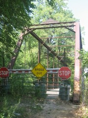 | Embarras River Bridge | structure | 1998 | 98000472 |
Every wildfire the federal occurrence database records inside this county: 1 of them, burning about 5 acres. None started naturally and none was recorded as arson. Each settlement page carries the fires within five miles of it.
| Reported cause | Fires |
|---|---|
| Debris and open burning | 1 |
The five largest, by the area the report gives. None of them was recorded as arson.
| Date | Cause | Size | Reported by | Name on the report |
|---|---|---|---|---|
| 14 October 2010 | Debris and open burning | 5.0 acres | Illinois Division of Forestry Resources | CALEB |
Every settlement page carries the fires within five miles of it - see the settlement index below.
The NOAA Storm Events Database holds 231 reports for this county, causing no deaths, 11 injuries and about $3,422,000 in recorded property damage. Each settlement page carries the reports that name it.
| Kind of event | Reports |
|---|---|
| Thunderstorm Wind | 103 |
| Hail | 60 |
| Flash Flood | 40 |
| Tornado | 20 |
| Flood | 7 |
| Funnel Cloud | 1 |
The most serious of them, by death, then injury, then recorded damage. The accounts are quoted exactly as the forecast office filed them.
| When | Event | Place named | Harm | What the report says |
|---|---|---|---|---|
| June 1990 | Tornado (F4) | not stated | 6 hurt, $250,000 | no account filed |
| April 1984 | Tornado (F1) | not stated | 1 hurt, $250,000 | no account filed |
| April 2011 | Thunderstorm Wind | Bogota | 1 hurt, $120,000 | Four camping trailers were blown over at Kuhl's Kozy Kampground. A tree fell on one trailer cutting it in half. One person sustained minor injuries. |
| August 2007 | Thunderstorm Wind | Wheeler | 1 hurt, $26,000 | Numerous trees, tree limbs, and power lines were blown down. A man was injured by a falling tree limb in Wheeler. Shingles and tin were blown off a roof in Newton. A semi trailer was blown over between Wheeler and Newton. |
| May 2018 | Thunderstorm Wind | Boos | 1 hurt, $10,000 | A semi-trailer was blown over about 7 miles south of Newton, injuring the driver. |
| April 2011 | Thunderstorm Wind | Bogota | 1 hurt, $10,000 | Part of a metal roof was blown off a house just west of Kuhl's Kozy Kampground. |
| April 1994 | Thunderstorm Wind | Newton | $500,000 | Trees and power lines were blown down in Newton. There were several reports of roof damage. |
| June 2009 | Thunderstorm Wind | Boos | $345,000 | Numerous trees and power lines were blown down across southeast Jasper County. Several houses had shingles blown off of them and a front porch was destroyed on one home. A hog farm reported extensive roof damage to 4 of its hog confinement buildings, with estimated repair costs of around $150,000. In addition, two barns were destroyed and a few farms had minor grain bin damage. |
| November 2013 | Tornado (EF1) | West Liberty | $250,000 | A tornado touched down on the northwest side of West Liberty at 12:25 PM CST, then tracked northeastward before lifting 3.4 miles ENE of West Liberty at 12:29 PM CST. Roof and siding damage occurred to 12 homes, while the roof was completely torn off an older one-story house. A semi-truck was overturned and several trees were uprooted. A barn was destroyed and 2 sheds had their roofs torn off about 1 mile ENE of West Liberty before the tornado dissipated. |
| June 2008 | Flash Flood | Island Grove | $150,000 | Portions of IL Route 33 closed due to high water. Multiple basements flooded and some bridges washed out around Jasper County. |
| February 2008 | Thunderstorm Wind | Gila | $121,000 | Numerous trees and power lines were blown down over northern Jasper county. Several structures sustained minor roofing and siding damage. At least 29 dairy cows were electrocuted when a downed power line fell on their barn. One unanchored mobile home was destroyed. |
| July 2017 | Thunderstorm Wind | Newton | $110,000 | Numerous trees and power lines were blown down across Newton. One large tree fell onto a house. |
| June 2008 | Thunderstorm Wind | St Marie | $82,000 | Numerous trees, tree limbs, and power lines were blown down. One tree fell on a house and tore off gutters, while another tree fell on two cars. Several structures sustained damage, including four machine sheds that had their roof blown off and a hog barn that was destroyed. |
| June 2016 | Thunderstorm Wind | Willow Hill | $70,000 | Route 33 between Willow Hill and Oblong was closed due to numerous power poles being blown down. |
| April 2006 | Thunderstorm Wind | Newton | $70,000 | Roof damage reported to several homes and outbuildings in Newton. In addition, trailers flipped at a local dealership and numerous trees blown down. Machine shed destroyed and grain bins damaged near Ste. Marie. |
| October 2010 | Thunderstorm Wind | Wheeler | $65,000 | Two concrete silos were destroyed and some cattle were injured north of Wheeler. |
| June 2008 | Flood | St Marie | $60,000 | As a result of very heavy rainfall over east-central Illinois, the Embarras River at Ste. Marie reached an all-time record stage of 28.01 feet at 2315 CST on 6/7. Widespread flooding impacted a few homes near the Embarras River, but the largest impact was to agriculture near Ste. Marie and to the southeast. Jasper County was declared a disaster area due to the flooding. |
| May 2013 | Thunderstorm Wind | Island Grove | $55,000 | Several trees and power poles were blown down near Island Grove. |
| April 2017 | Thunderstorm Wind | St Marie | $50,000 | Three machine sheds were damaged south of Ste. Marie, including one that had its roof blown off. A power pole was broken and power lines were downed, causing a power outage. |
| May 2015 | Thunderstorm Wind | Newton | $50,000 | Several trees and power lines were blown down on the southwest side of Newton. |
| October 2010 | Thunderstorm Wind | Gila | $50,000 | The roof of the Island Grove School was damaged in Gila. In addition, trees were uprooted and an old barn had some of its metal roofing blown off southwest of town. |
| June 2009 | Thunderstorm Wind | Newton | $50,000 | Local law enforcement reported several trees blown down across Jasper County. Around 200 Norris Electric customers lost power. |
| May 1995 | Thunderstorm Wind | NW Jasper | $50,000 | Numerous trees and power lines were blown down over northwest Jasper county. |
| June 2009 | Thunderstorm Wind | St Marie | $45,000 | Strong winds damaged a few roofs near West Liberty and Ste. Marie. |
| May 2015 | Thunderstorm Wind | Hidalgo | $40,000 | The roofs of a machine shed and hog building were blown off. A nearby home sustained damage from flying debris from the two structures: however, no injuries were reported. |
| June 2013 | Flash Flood | Island Grove | $40,000 | Slow moving thunderstorms, which produced 3.00 to 4.00 inches of rain on already saturated ground from the late evening of May 31st through the night, resulted in flash flooding across all of Jasper County which continued into the early afternoon of June 1st. The flash flooding made many rural roads impassable, and flooded numerous streets in the city of Newton. A mobile home near the town of Wheeler was evacuated due to high water entering the home during the early morning of June 1st. |
| July 2016 | Thunderstorm Wind | Newton | $25,000 | Numerous trees were blown down in Newton. |
| September 2014 | Thunderstorm Wind | St Marie | $25,000 | A large machine shed was damaged. |
| August 2012 | Thunderstorm Wind | Newton | $25,000 | Numerous tree branches and power lines were blown down in Newton. |
| June 1990 | Tornado (F1) | not stated | $25,000 | no account filed |
| May 1989 | Tornado (F1) | not stated | $25,000 | no account filed |
| March 1976 | Tornado (F0) | not stated | $25,000 | no account filed |
| August 1974 | Tornado (F3) | not stated | $25,000 | no account filed |
| December 1957 | Tornado (F3) | not stated | $25,000 | no account filed |
| September 2014 | Thunderstorm Wind | St Marie | $20,000 | Numerous trees were blown down just west of Sainte Marie. |
| February 2011 | Thunderstorm Wind | Wheeler | $20,000 | Several trees were blown down. |
| June 2016 | Thunderstorm Wind | Willow Hill | $15,000 | Several power lines were blown down in Willow Hill. |
| September 2014 | Thunderstorm Wind | St Marie | $15,000 | Numerous 12-inch diameter tree branches were blown down. |
| April 2011 | Thunderstorm Wind | Newton | $15,000 | A tree was blown down, damaging part of a trailer home. |
| May 2011 | Thunderstorm Wind | Yale | $15,000 | Several trees were blown down in Yale. |
| June 2011 | Thunderstorm Wind | Yale | $15,000 | The roof was blown off the firehouse in Yale. |
| June 2010 | Thunderstorm Wind | Yale | $15,000 | Numerous power lines and poles were blown down. |
| June 2010 | Thunderstorm Wind | Newton | $15,000 | Numerous power poles and lines were downed around town. |
| July 2008 | Thunderstorm Wind | Newton | $15,000 | Numerous tree limbs and a power pole were blown down in Newton. |
| October 2007 | Thunderstorm Wind | Wheeler | $15,000 | Numerous trees were blown down.| |
| May 2003 | Tornado (F1) | Wheeler | $15,000 | A tornado briefly touched down damaging the roofs on two homes, blew down numerous trees and power lines and damaged a couple of sheds. No injuries were reported. |
| October 2010 | Thunderstorm Wind | Wheeler | $12,000 | Several 4 to 8-inch diameter tree limbs were blown down and a 3-foot diameter tree was uprooted. |
| June 2008 | Thunderstorm Wind | Newton | $12,000 | A horse barn was blown down and skirting was torn off a nearby mobile home. In addition, a few tree limbs were blown down. |
| February 2026 | Tornado (EF0) | Wheeler | $10,000 | Video from a storm chaser showed a tornado develop about one mile southeast of Wheeler. The tornado caused minor damage to trees as it travelled northeast across Highway 33 before dissipating just east of N 500th St. |
| April 2017 | Thunderstorm Wind | St Marie | $10,000 | A hog confinement building was destroyed near the Jasper-Crawford County line. |
| December 2015 | Thunderstorm Wind | Newton | $10,000 | Minor damage to the roof of a house and a carport occurred on Davis Street in Newton. |
| September 2012 | Thunderstorm Wind | Newton | $10,000 | Several tree branches were blown down in Newton. |
| July 2012 | Thunderstorm Wind | Newton Flying Clb Ar | $10,000 | Power lines were blown down onto East 600th Avenue about 3 miles south of Newton. |
| April 2011 | Thunderstorm Wind | Newton | $10,000 | A few small trees were blown down. |
| June 2018 | Thunderstorm Wind | St Marie | $9,000 | Several one to three-inch diameter tree branches were blown down causing a power outage. |
| May 2011 | Thunderstorm Wind | Rose Hill | $5,000 | A tree was blown down into powerlines. |
| January 2008 | Thunderstorm Wind | Newton | $5,000 | A few trees were blown down between Newton and Yale. |
| July 2012 | Thunderstorm Wind | Willow Hill | $3,000 | A tree was blown down at the IL33/49 junction about 6 miles E/NE of Newton. |
| May 1974 | Tornado (F1) | not stated | $2,500 | no account filed |
| July 2008 | Thunderstorm Wind | Hidalgo | $2,000 | A power line was blown down near Hidalgo. |
The Survey's mineral resources record lists 2 workings inside this county. None of them still produces: all are closed or unrecorded. Each settlement page carries the workings within five miles of it.
| Commodity | Workings |
|---|---|
| Sand and Gravel, Construction, Stone | 1 |
| Clay | 1 |
The least common of them first, because a county's hundredth gravel pit says nothing its first ten did not.
| Where | Site | Commodity | Status | Recorded |
|---|---|---|---|---|
| Jasper Cty Hwy Dept Pit | Sand and Gravel, Construction, Stone | Past Producer | ||
| Mc Leansboro Shale Exposure | Clay | Prospect |
Named settlements recorded in the Geographic Names Information System, each with the topographic sheets covering it. Villages, hamlets and abandoned places alike. Each is shown with the nearest named watercourse or landform and the survey quadrangle it falls on.
Hunt City township · 62448 · On East Crooked Creek · Yale quadrangle
13 sheets, 1940 to 1998