 Block
From the record
6 National Register listings published here.
Sources: the National Register database, National Park Service
49 topographic sheets cover 21 settlements here, and 6 properties are on the National Register of Historic Places.
6 National Register listings published here.
Sources: the National Register database, National Park Service
Every property in this county listed on the National Register of Historic Places, with the year it was listed and the federal nomination document.
| Photograph | Property | Type | Listed | Reference |
|---|---|---|---|---|
| Lincoln's New Salem Village | district | 1972 | 72000464 | |
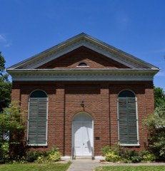 | North Sangamon United Presbyterian Church | building | 1979 | 79000858 |
 | Petersburg Historic District | district | 1976 | 76000722 |
 | Petersburg Historic District (Boundary Increase) | building | 1986 | 86000138 |
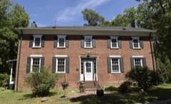 | Robinson-Bonnett Inn | building | 1990 | 90001198 |
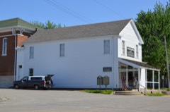 | Col. Matthew Rogers Building | building | 2005 | 05000431 |
Every wildfire the federal occurrence database records inside this county: 24 of them, burning about 29 acres. None started naturally and none was recorded as arson. Each settlement page carries the fires within five miles of it.
| Reported cause | Fires |
|---|---|
| Debris and open burning | 17 |
| Missing data/not specified/undetermined | 6 |
| Equipment and vehicle use | 1 |
The five largest, by the area the report gives. None of them was recorded as arson.
| Date | Cause | Size | Reported by | Name on the report |
|---|---|---|---|---|
| 30 March 2015 | Debris and open burning | 10 acres | Illinois Division of Forestry Resources | 2015-000064 |
| 21 March 2015 | Debris and open burning | 5.0 acres | Illinois Division of Forestry Resources | 2015-000059 |
| 25 March 2016 | Debris and open burning | 3.0 acres | Illinois Division of Forestry Resources | 2016-000041 |
| 26 April 2014 | Debris and open burning | 2.0 acres | Illinois Division of Forestry Resources | 14-000060 |
| 19 June 2017 | Debris and open burning | 1.0 acres | Illinois Division of Forestry Resources | 2017-000137 |
| 20 February 2017 | Debris and open burning | 1.0 acres | Illinois Division of Forestry Resources | 2017-000041 |
| 28 March 2015 | Debris and open burning | 1.0 acres | Illinois Division of Forestry Resources | 2015-000062 |
| 12 April 2010 | Missing data/not specified/undetermined | under an acre | Illinois Division of Forestry Resources | HURIE |
Every settlement page carries the fires within five miles of it - see the settlement index below.
The NOAA Storm Events Database holds 258 reports for this county, causing no deaths, 7 injuries and about $14,598,000 in recorded property damage. Each settlement page carries the reports that name it.
| Kind of event | Reports |
|---|---|
| Thunderstorm Wind | 139 |
| Hail | 79 |
| Flash Flood | 23 |
| Tornado | 14 |
| Flood | 2 |
| Lightning | 1 |
The most serious of them, by death, then injury, then recorded damage. The accounts are quoted exactly as the forecast office filed them.
| When | Event | Place named | Harm | What the report says |
|---|---|---|---|---|
| June 1998 | Thunderstorm Wind | Petersburg | 3 hurt | Thunderstorm winds blew down a beer tent at the county fair. The tent injured 3 people, one seriously. Also, numerous trees, tree limbs, and power lines were blown down countywide. |
| July 2008 | Flash Flood | Athens | 2 hurt, $40,000 | Two 8-inch diameter culverts were washed out on Harvest Road southwest of Athens. A car plunged into the void, resulting in two minor injuries. |
| December 2010 | Tornado (EF3) | Lincns New Salem St | 1 hurt, $12,000,000 | A tornado touched down on the west side of Lake Petersburg at 12:37 PM CST, then tracked northeast over the lake and across Sunny Acres Road, before lifting southeast of the intersection of Tice Road and Illinois 123 at 12:40 PM CST. A total of 29 homes sustained significant structural damage, four of which could not be repaired. Two barns were also destroyed, and nearly 100 houses and a nursing home had minor damage along the path of the tornado. One person was seriously injured when the tornado caused a large tree limb to fall on their automobile, crushing the car and trapping the occupant. |
| July 1997 | Thunderstorm Wind | Athens | 1 hurt | Thunderstorm winds blew a tent over in a park in Athens resulting in a minor injury to one person. Also, numerous power lines and tree limbs were blown down. No other injuries were reported and no damage estimate was available. |
| May 1996 | Flash Flood | Countywide | $1,000,000 | no account filed |
| April 2011 | Tornado (EF1) | Culver | $450,000 | A tornado touched down in a field 3 miles northeast of Athens at 625 PM CDT. It tracked northward...damaging the roof of a house, destroying a small garage, and damaging several automobiles. Further north, the tornado knocked two trees down onto a house, doing severe damage to its roof and interior walls. It then tipped over a semi-trailer and damaged several trees before dissipating 4.8 miles north-northeast of Athens at 631 PM CDT. |
| June 2011 | Thunderstorm Wind | Sweet Water | $200,000 | Downburst thunderstorm winds of 75 to 85 mph produced a path of damage from Sweetwater to approximately 3 miles east of Sweetwater. Numerous trees and tree branches were blown down and several trees were uprooted. In addition, a few homes sustained minor roofing damage, as did several grain bins and farm outbuildings. |
| August 1999 | Thunderstorm Wind | Petersburg | $75,000 | Trees were blown down countywide, as well as, 11 power poles along Route 29 just north of Athens.One tree fell onto a house and truck just north of Petersburg. No injuries were reported. Thousands of acres of corn were flattened, especially in the northern part of the county. Damage to the crops was estimated around $6 million. |
| July 2008 | Flash Flood | Athens | $65,000 | High flowing water washed out a bridge and road on the south side of Athens. Parts of IL Route 29 were flooded between IL Route 123 and the town of Athens. |
| June 2015 | Thunderstorm Wind | Greenview | $60,000 | Several utility poles were blown down along North Middletown Blacktop. |
| June 2014 | Thunderstorm Wind | Tallula | $60,000 | Several tree branches and power lines were blown down. |
| June 2011 | Thunderstorm Wind | Petersburg | $50,000 | Several trees were blown down in Petersburg. |
| April 2009 | Lightning | Petersburg | $50,000 | Lightning struck the water treatment plant in Petersburg. The lightning damaged the automatic control system and security system. There were no injuries and water service was not disrupted. |
| May 2016 | Thunderstorm Wind | Curtis | $45,000 | Seven power poles were snapped at Cline St and Illinois Route 123 east of Petersburg. |
| June 2008 | Thunderstorm Wind | Oakford | $40,000 | Numerous trees, power lines, and power poles were blown down across Menard County. A concentrated area of 17 power poles was blown down on Route 29 just north of Greenview. |
| June 2016 | Thunderstorm Wind | Greenview | $36,000 | Numerous trees and tree branches were blown down in Greenview. One power pole was snapped. |
| November 2013 | Thunderstorm Wind | Greenview | $35,000 | Several large trees and power lines were blown down on Rt. 29. |
| June 2016 | Thunderstorm Wind | Petersburg | $30,000 | Several tree branches and power lines were blown down along IL-97 from Petersburg to Oakford. |
| May 2016 | Thunderstorm Wind | Culver | $30,000 | Several trees were blown down near Illinois Route 29 and Indian Point Road. |
| June 2010 | Thunderstorm Wind | Atterberry | $25,000 | Several trees were uprooted along a half mile path near Atterberry. |
| April 2017 | Thunderstorm Wind | Petersburg | $24,000 | A three-foot diameter oak tree was blown down. Several other trees and power lines were blown down as well. |
| April 2011 | Thunderstorm Wind | Sweet Water | $20,000 | Downburst winds did minor damage to a lean-to-shed and the roof of a house and knocked down several trees at the Sugar Grove Cemetary. |
| June 2011 | Thunderstorm Wind | Petersburg | $20,000 | Several trees were blown down in Petersburg. |
| June 2010 | Thunderstorm Wind | Petersburg | $20,000 | A 2 to 3-foot diameter tree fell onto a house north of the courthouse in Petersburg. In addition, numerous small branches were blown down around town. |
| July 2008 | Flash Flood | Petersburg | $20,000 | A culvert was washed out on Foggy Bottom Avenue 7 miles south of Petersburg. |
| May 2016 | Thunderstorm Wind | Petersburg | $18,000 | Multiple tree limbs were blown down and an apple tree was snapped at the base. |
| June 2015 | Tornado (EF0) | Culver | $15,000 | A tornado briefly touched down 8 miles east of Petersburg at 8:22 PM CDT. The tornado knocked down several trees and damaged an old barn. An anemometer at the residence where the damage occurred measured a peak wind of 77 mph. The tornado quickly dissipated by 8:23 PM CDT. |
| June 2011 | Thunderstorm Wind | Greenview | $15,000 | Numerous trees were blown down in Greenview. |
| June 2010 | Thunderstorm Wind | Tice | $15,000 | Several 2 to 3-foot diameter trees were blown down in the Chautauqua Park area north of the Athens Blacktop. |
| June 2010 | Thunderstorm Wind | Oakford | $15,000 | A tree was blown down onto a car in Oakford. |
| May 2009 | Thunderstorm Wind | Athens | $15,000 | Large tree limbs were blown down in Athens. |
| May 2012 | Thunderstorm Wind | Petersburg | $14,000 | A few trees were blown down and roofing was torn off a home. |
| May 2013 | Thunderstorm Wind | Lincns New Salem St | $12,000 | Several trees were blown down near New Salem Park and Highway 97. |
| May 2013 | Thunderstorm Wind | Lincns New Salem St | $12,000 | A few trees were blown down at New Salem State Park along State Highway 97. |
| April 2011 | Tornado (EF0) | Athens | $10,000 | A tornado touched down in a field 1 mile northeast of Athens at 622 PM CDT. It moved north-northwest...damaging a window, siding, and gutters on a house before dissipating 2 miles north-northeast of Athens at 624 PM CDT. |
| November 2013 | Thunderstorm Wind | Petersburg | $8,000 | Several tree limbs were blown down in Petersburg. |
| July 2010 | Thunderstorm Wind | Oakford | $8,000 | Four to five inch diameter branches and a few light poles were blown down. |
| May 2008 | Thunderstorm Wind | Culver | $7,000 | Strong winds broke off the top of a couple healthy trees. The winds also caused minor roof damage to an outbuilding and a barn. |
| May 2009 | Thunderstorm Wind | Greenview | $6,000 | A power pole was knocked down and shingles were blown off a roof. |
| June 2011 | Thunderstorm Wind | Petersburg | $5,000 | A 20-foot ornamental tree was snapped 3 feet above the ground and 4-inch diameter tree branches were blown down over Route 97. |
| September 2014 | Thunderstorm Wind | Athens | $4,000 | Power lines were blown down onto a house in Athens. |
| June 2010 | Thunderstorm Wind | Petersburg | $4,000 | A large tree limb and power line were blown down. |
| May 2009 | Thunderstorm Wind | Greenview | $4,000 | Several branches were blown down in eastern Menard County. |
| June 2014 | Thunderstorm Wind | Petersburg | $3,000 | A large tree and a power line were blown down. |
| June 2010 | Thunderstorm Wind | Petersburg | $3,000 | A tree was blown down. |
| June 2016 | Thunderstorm Wind | Greenview | $2,000 | A 4-foot diameter tree was blown down across IL-29 on the north side of Greenview. |
| June 2016 | Thunderstorm Wind | Greenview | $2,000 | A four-foot diameter tree was blown down in Greenview. |
| June 2010 | Thunderstorm Wind | Sweet Water | $2,000 | A tree was blown down on Middletown Road between Middletown and Greenview. |
| July 2009 | Thunderstorm Wind | Greenview | $2,000 | A large tree was blown down in Greenview. |
| September 2014 | Thunderstorm Wind | Petersburg | $1,000 | A large tree limb was blown down in Petersburg just south of the IL-123 and 97 junction. |
| June 2010 | Thunderstorm Wind | Oakford | $1,000 | A window was blown out of a house on Lincoln Trail Road. |
| March 2025 | Thunderstorm Wind | Greenview | - | A tree was blown down, resulting in damage to a garage and power lines. |
| May 2025 | Hail | Athens | - | Ping-pong ball sized hail fell at Athens Community Park. |
| May 2025 | Thunderstorm Wind | Athens | - | Scattered tree damage occurred throughout Athens. |
| May 2025 | Thunderstorm Wind | Lincns New Salem St | - | A farm shed was destroyed on Hurie Avenue west of Highway 97 and a sign was blown over on Highway 97. |
| May 2025 | Thunderstorm Wind | Athens | - | Wind-driven hail damage occurred to a home north of Athens. |
| June 2025 | Tornado (EF1) | Tallula | - | Sentinel satellite data indicated a tornado began 2.6 miles northwest of Berlin in Sangamon County. The tornado tracked northeast through Sangamon County, damaging trees and grain bins, eventually crossing County Road 7 into Menard County. It produced tree damage at a residence just north of County Road 7, as well as a residence along Rock Creek Avenue, after which point it dissipated. It produced EF-1 damage in both Sangamon and Menard counties. |
| June 2025 | Tornado (EFU) | Tallula | - | Video shared by a trained spotter showed a brief tornado began in eastern Cass County south of Newmansville. Sentinel satellite imagery showed the tornado tracking for approximately 1.8 miles through Cass County before crossing County Line Road north of Pschirrer Road and continuing into western Menard County. The tornado continued for 1.3 miles before dissipating north of Newmansville Avenue. No damage was reported in either county, so a damage intensity rating could not be assigned. |
| June 2025 | Thunderstorm Wind | Atterberry | - | Sentinel satellite imagery showed an area of mild crop damage oriented towards the northeast. The area of crop damage extended from near the intersection of Fairgrounds Street and Cape Horn Hill Road northeast towards the Sangamon River, ending at Wilken Avenue. |
| June 2025 | Tornado (EF1) | Atterberry | - | The tornado began along Ed Hinrichs Road, where it produced minor damage to trees. It then moved northeast, destroying five grain bins and removing the tops of hardwood trees at a farmstead along Gellerman Road. The last observed damage was at a pair of homes along Newmansville Avenue, where large, healthy tree limbs were blown off of hardwoord trees, numerous evergreen trees were topped, and shingles were removed from both homes. The tornado was rated EF-1. ||EF-1 tornado with max winds of 110 mph. It tracked 1.4 miles and caused tree damage, destroyed 5 grain bins, and removed shingles from two homes. |
The Survey's mineral resources record lists 9 workings inside this county. 1 still produces and 8 are closed or unrecorded. Each settlement page carries the workings within five miles of it.
| Commodity | Workings |
|---|---|
| Stone, Crushed/Broken | 6 |
| Stone | 2 |
| Clay | 1 |
The least common of them first, because a county's hundredth gravel pit says nothing its first ten did not.
| Where | Site | Commodity | Status | Recorded |
|---|---|---|---|---|
| Springfield Clay Prod.Co.Clay Pit | Clay | Past Producer | ||
| Menard County Pit | Stone | Past Producer | ||
| Petersburg City Pit | Stone | Past Producer | ||
| Athens Quarry | Stone, Crushed/Broken | Past Producer | ||
| Indian Point Quarry | Stone, Crushed/Broken | Producer | ||
| Limestone Prospect | Stone, Crushed/Broken | Occurrence | ||
| Limestone Prospect | Stone, Crushed/Broken | Occurrence | ||
| Unnamed Limestone Quarry | Stone, Crushed/Broken | Past Producer | ||
| Unnamed Limestone Quarry | Stone, Crushed/Broken | Past Producer |
Named settlements recorded in the Geographic Names Information System, each with the topographic sheets covering it. Villages, hamlets and abandoned places alike. Each is shown with the nearest named watercourse or landform and the survey quadrangle it falls on.
Oakford No. 9 precinct · 62673 · On Little Grove Creek · Oakford quadrangle
13 sheets, 1933 to 1990
Fancy Prairie No. 3 precinct · 62613 · Williamsville quadrangle
17 sheets, 1907 to 1985
Irish Grove No. 4 precinct · 62642 · On Pike Creek · Mason City quadrangle
14 sheets, 1948 to 1990
Petersburg South No. 15 precinct · 62675 · On Rocky Branch · Salisbury quadrangle
14 sheets, 1909 to 1985
Petersburg East No. 13 precinct · 62675 · On Rocky Branch · Salisbury quadrangle
14 sheets, 1909 to 1985
Petersburg East No. 13 precinct · 62675 · On Rocky Branch · Salisbury quadrangle
14 sheets, 1909 to 1985
No longer a settlement
Oakford No. 9 precinct · 62673 · Near Mott Hollow · Oakford quadrangle
13 sheets, 1933 to 1990
Petersburg East No. 13 precinct · 62675 · On Hemp Factory Branch · Salisbury quadrangle
14 sheets, 1909 to 1985
Petersburg East No. 13 precinct · 62675 · On Hemp Factory Branch · Petersburg quadrangle
13 sheets, 1933 to 1990
The vanished settlements of Menard County: the places named above that are no longer on the map.