 Block
From the record
3 National Register listings published here.
Sources: the National Register database, National Park Service
62 topographic sheets cover 20 settlements here, and 3 properties are on the National Register of Historic Places.
3 National Register listings published here.
Sources: the National Register database, National Park Service
Every property in this county listed on the National Register of Historic Places, with the year it was listed and the federal nomination document.
| Photograph | Property | Type | Listed | Reference |
|---|---|---|---|---|
 | Du Quoin State Fairgrounds | district | 1990 | 90000719 |
| Paradise Missionary Baptist Church | building | 2024 | 100010212 | |
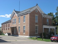 | Perry County Jail | building | 2000 | 00000943 |
Every wildfire the federal occurrence database records inside this county: 28 of them, burning about 637 acres. None started naturally and none was recorded as arson. Each settlement page carries the fires within five miles of it.
| Reported cause | Fires |
|---|---|
| Missing data/not specified/undetermined | 17 |
| Debris and open burning | 6 |
| Equipment and vehicle use | 4 |
| Recreation and ceremony | 1 |
The five largest, by the area the report gives. None of them was recorded as arson.
| Date | Cause | Size | Reported by | Name on the report |
|---|---|---|---|---|
| 13 March 2007 | Missing data/not specified/undetermined | 225 acres | Illinois Division of Forestry Resources | not named |
| 18 March 2005 | Debris and open burning | 160 acres | Illinois State Fire Marshal's Office | not named |
| 27 February 2004 | Debris and open burning | 150 acres | Illinois State Fire Marshal's Office | not named |
| 3 November 2008 | Missing data/not specified/undetermined | 15 acres | Illinois Division of Forestry Resources | MARLOW |
| 19 February 2016 | Missing data/not specified/undetermined | 15 acres | Illinois Division of Forestry Resources | WHITE WALNUT RD |
| 9 March 2007 | Equipment and vehicle use | 10 acres | Illinois Division of Forestry Resources | not named |
| 19 March 2010 | Missing data/not specified/undetermined | 10 acres | Illinois Division of Forestry Resources | ENGLEHARDT |
| 27 August 2007 | Missing data/not specified/undetermined | 6.0 acres | Illinois Division of Forestry Resources | not named |
Every settlement page carries the fires within five miles of it - see the settlement index below.
The NOAA Storm Events Database holds 314 reports for this county, causing 1 death, 26 injuries and about $10,188,700 in recorded property damage. Each settlement page carries the reports that name it.
| Kind of event | Reports |
|---|---|
| Thunderstorm Wind | 127 |
| Hail | 75 |
| Flash Flood | 40 |
| Heavy Rain | 24 |
| Tornado | 21 |
| Flood | 20 |
| Funnel Cloud | 5 |
| Lightning | 2 |
The most serious of them, by death, then injury, then recorded damage. The accounts are quoted exactly as the forecast office filed them.
| When | Event | Place named | Harm | What the report says |
|---|---|---|---|---|
| December 1957 | Tornado (F5) | not stated | 1 killed, 6 hurt, $250,000 | no account filed |
| May 1982 | Tornado (F3) | not stated | 7 hurt, $250,000 | no account filed |
| June 2009 | Thunderstorm Wind | Du Quoin | 2 hurt, $1,300,000 | Downburst winds affected a swath of eastern and southern Perry County. The heart of the damage swath cut a path through the northeast and east sides of DuQuoin. The average path width was three-quarters of a mile. The damage path length was about six miles long. Many dozens to hundreds of trees were down on homes, vehicles, power lines, and other structures. Eight homes received major damage, and 82 others had minor damage. Nine vehicles were destroyed. A large portion of the metal roof was blown off a large industrial building. A semi trailer was overturned. Approximately 40 power poles were destroyed. Up to 1200 citizens were without power. There were two minor injuries due to falling debris. Peak winds were estimated near 75 mph. |
| March 2006 | Tornado (F2) | Cutler | 2 hurt, $1,200,000 | The tornado entered Perry County, IL from Randolph County about 1.5 miles south of Highway 154. The Perry County segment of the tornado was rated at its maximum intensity and width shortly after crossing the county line. Shortly after crossing into Perry County, some coal trucks were blown over, and a modular home was totally destroyed on Route 154 near Route 150. Two persons in the home were trapped inside for a time, but they sustained only minor injuries that were treated at a local hospital. Route 150 was closed for 12 hours due to downed trees and power lines. Within a few miles of the destroyed modular home, some hogs were killed at a hog farm, and an empty grain bin was picked up and blown 100 yards into a field. Several eyewitnesses at this location reported two funnels. As the tornado continued its northeast movement, passing northwest of Pinckneyville, it weakened to F1 intensity. Near where it crossed Illinois Route 13, trees were uprooted, roofs were blown off, and power poles were snapped. Siding was blown off a house. Near the end of the tornado track, just northwest of Tamaroa, a metal building was destroyed. Debris from the building was blown about 400 yards. A nearby house lost all of its shingles. Along the 20-mile path through Perry County, dozens of barns and outbuildings were severely damaged or destroyed. Dozens of homes sustained varying degrees of damage, ranging from minor to major. Hundreds of trees were uprooted or snapped. Peak winds on this county segment were estimated at 140 MPH, mainly near the Randolph County line. The average path width was close to 200 yards. A deputy sheriff reported a tornado crossing U.S. Highway 51 north of Tamaroa. This was the last evidence of the tornado, which likely dissipated as it crossed Route 51. |
| April 2011 | Thunderstorm Wind | Pyatts | 2 hurt, $1,000,000 | Extensive damage occurred in the DuQuoin area. Two concentrated areas of damage were observed. The first area extended northeastward into the southwest portion of DuQuoin. Another concentrated area was southeast of DuQuoin. Wind gusts were measured at three separate locations south and southwest of DuQuoin. The measurements were 88 mph, 66 mph, and 61 mph. The wind gust to 66 mph was measured at the DuQuoin/Perry County airport. Emergency management personnel reported that 55 single family dwellings were damaged, including six that were extensively damaged and one that was a total loss. The majority of these homes received only shingle loss or minor roof damage. One mobile home was damaged, and six businesses were damaged. Six barns were damaged, and three other barns were destroyed. The majority of the damaged and destroyed structures were in the DuQuoin area. There was widespread damage to trees and power lines, as well. Two 69,000-volt transmission lines that feed the city were brought down. The entire city of DuQuoin was without power after the storm for more than 12 hours. Power was restored to the downtown area about 24 hours later. Numerous poles were brought down, some by trees falling on wires. |
| June 2011 | Tornado (EF1) | Clinch | 1 hurt, $550,000 | A tornado crossed through the DuQuoin State Fairgrounds, where damage was estimated around one-half million dollars. Dozens of large trees were snapped or uprooted. Several small camper trailers were overturned. One unoccupied trailer was demolished. Three persons were trapped inside a camper at the DuQuoin State Fairgrounds. They were extricated by fire and rescue personnel. One person sustained minor injuries in an overturned trailer. Several homes lost some shingles and sustained mainly minor damage from fallen trees. At the state fairgrounds, a shower/restroom facility and the Farm Service building were destroyed by falling trees. Large hvac units were lifted off the roof of the main arena building and overturned. The doors of the building were damaged. A couple of uprooted trees ruptured gas lines. The peak winds were estimated near 100 mph. The average path width was 200 yards. |
| March 2020 | Tornado (EF1) | Sunfield | 1 hurt, $300,000 | The tornado started near the community of Sunfield on U.S. Highway 51. At least a dozen homes were damaged, including four with major structural damage. This included numerous broken windows and roof damage. One home had part of its roof decking removed, and another had its attached garage blown apart from the house. At least five camper trailers were blown over, with one lofted over 200 yards across a field. Several outbuildings and garages were partly or completely levelled. Dozens of trees were snapped or uprooted. Some power lines were down. A trained spotter witnessed the tornado. The tornado path crossed Du Quoin Lake and ended on Highway 154. Peak winds were estimated near 100 mph. |
| December 1957 | Tornado (F3) | not stated | 1 hurt, $250,000 | no account filed |
| July 2008 | Thunderstorm Wind | Pinckneyville | 1 hurt, $75,000 | About a mile northwest of Pinckneyville, a very large tree fell on a mobile home and destroyed it. One person was injured. Elsewhere around Pinckneyville, numerous trees were uprooted and a barn was destroyed. One tree fell across railroad tracks, stopping train traffic. Other trees fell on power lines. Several trees were down in Tamaroa. |
| May 2020 | Thunderstorm Wind | Cutler | 1 hurt, $20,000 | One female was injured by a falling six-inch tree branch. A passer-by removed the limb from her. Injuries were minor. Several trees and branches were down across Cutler. One tree was on a power line. Branches several inches in diameter were snapped. A trained spotter estimated peak winds were 60 to 65 mph. |
| December 2009 | Flood | Todds Mill | 1 hurt, $5,000 | A woman drove into a flooded area along a rural road northeast of Pinckneyville. She was rescued safely from the hood of her vehicle by sheriff and emergency medical personnel. She was treated for hypothermia at a local hospital. |
| June 2003 | Thunderstorm Wind | Pinckneyville | 1 hurt | In Pinckneyville, a large tree fell on a mobile home, destroying it. A nearby truck was damaged by a falling tree limb. One person received minor scrapes when he was struck by a falling branch. At a church camp in Perry County, about 15 trees were knocked down, including one that fell through the roof of a camp lodge. Guttering and siding were blown off a home. Just northeast of Pinckneyville, there was extensive damage to outbuildings and barns. A 20-by-30 foot shed door was blown 175 yards into a field. Damage to trees and sheds occurred in DuQuoin. A large tree limb fell on a mobile home just west of Pinckneyville, causing significant damage. |
| March 2025 | Tornado (EF2) | Matthews | $1,500,000 | An EF-2 tornado developed northwest of Vergennes in Jackson County and moved north northeast into Perry County Illinois at Zolter Road. It then moved northeast, passing to the west of DuQuoin and through the community of St Johns. It continued northeast and dissipated just north of Highway 154 at Marlow Road. The tornado snapped over a dozen wooden power poles, damaged the roofs of several homes, and damaged dozens of trees and a few barns and outbuildings. Just before it dissipated it broke several windows out of a church and turned over some gravestones in the adjacent cemetery. The estimated peak wind was 135 mph. |
| November 2017 | Tornado (EF0) | Du Quoin | $250,000 | The EF-0 tornado touched down just north of the downtown business district and tracked east through a residential area. Eyewitness reports of the tornado were obtained. The maximum estimated wind speed was 65 mph. Numerous homes and businesses sustained shingle and siding damage. A large tree fell onto a home. Hundreds of tree limbs were down, damaging several vehicles. Widespread power outages occurred. A power pole was snapped. A dozen mobile homes were damaged, including a mobile home that was moved off its foundation. The mobile home was not tied down. |
| March 2008 | Flood | Swanwick | $250,000 | A house along Beaucoup Creek near the Pinckneyville-Du Quoin Airport flooded. Water in the basement rose to within three inches of the floor joists. Four feet of water filled an adjacent barn. The mortar was washed out of the foundation blocks. The family used a boat to access the house. Numerous basements were flooded around the county, including more than 100 in Du Quoin alone. Sump pumps and shop vacs were sold out at many stores. Several roads were closed in Du Quoin. An intersection was closed by flooding in Du Quoin. |
| May 2004 | Tornado (F1) | Pinckneyville | $250,000 | The tornado began on Bethel Church Road and ended at the Washington County line near where U.S. Highway 51 crosses the county line. Five barns were destroyed directly by wind. Other damage was due mostly to trees falling on buildings. At least four residences were moderately damaged. A machinery storage building and sheds were demolished. An airplane hangar was destroyed. Numerous trees were blown down, blocking some roads. At a church camp along the Washington County line, many trees were blown down, including one that fell on the camp office. A house was damaged. Peak winds were estimated near 90 MPH. |
| May 1982 | Tornado (F3) | not stated | $250,000 | no account filed |
| December 1967 | Tornado (F3) | not stated | $250,000 | no account filed |
| April 1996 | Flash Flood | Pinckneyville | $220,000 | no account filed |
| December 2015 | Tornado (EF1) | Pinckneyville | $175,000 | Peak winds were estimated near 95 mph. Numerous trees were snapped off near the base or uprooted. A portion of Route 154 was closed due to downed trees. Several homes sustained minor to major roof damage. Most of the damaged homes were located near the start of the damage track near Route 154. Several barns received significant damage. The tornado track ended on the south end of Tamaroa, where some tree limbs were broken. |
| October 2012 | Thunderstorm Wind | Du Quoin | $100,000 | A microburst with estimated wind gusts up to 90 mph occurred along Highway 14. Several roofs were damaged on homes and farm buildings. A church was damaged. Underpinning was blown from a mobile home. A radio antenna was bent. A tree landed on a carport. Another tree landed on a house. Numerous trees and power lines were blown down. |
| March 2025 | Thunderstorm Wind | Jamestown | $80,000 | The roof of a trailer was blown off on Lincoln Street in Cutler and two barns were destroyed. |
| June 2006 | Thunderstorm Wind | Pinckneyville | $75,000 | Extensive damage to trees and power lines occurred. Some trees landed on homes, vehicles, and power lines. Part of the roof was taken off an abandoned building that was open on the south side, the direction from which the storm approached. One lane of Illinois Route 13 was blocked by downed tree limbs and large sections of sheet metal roofing blown off a storage building. A few other streets were blocked by trees. |
| June 2018 | Thunderstorm Wind | Tamaroa | $60,000 | Widespread wind damage occurred across the county. Multiple trees were down, causing numerous power outages. Some entire towns were in the dark, including Tamaroa. At least one tree landed on a structure. |
| May 2022 | Thunderstorm Wind | Du Quoin | $50,000 | Several large trees were snapped or uprooted, and large limbs were blown down. A couple of the limbs landed on roads and houses. Shingles were blown off a few houses. One older house sustained significant roof damage. |
| January 2013 | Thunderstorm Wind | Du Quoin | $50,000 | On the southwest side of DuQuoin, an attached garage was destroyed. The garage door was blown completely in, and the back wall of the garage was knocked out. Trees were blown down around the damaged house. South of DuQuoin along Route 14, a barn was destroyed. Trained spotters reported leaning power poles and tree damage in Old DuQuoin. |
| April 2011 | Thunderstorm Wind | Pinckneyville | $50,000 | A wind gust to 64 mph was measured on Highway 152. A large tree fell on a house in Pinckneyville. The uprooted tree fell onto the back room of the house. A hole was punctured in the roof, and a shed was damaged. |
| April 2006 | Thunderstorm Wind | Du Quoin | $50,000 | Widespread wind damage occurred in DuQuoin, including dozens of downed trees and limbs. Some of the trees landed across streets and on power lines. A house was damaged by a falling tree. State police reported 1,000 utility customers lost power, some for 12 to 24 hours. Some roofs sustained minor to moderate damage. A theater roof was moderately damaged, with debris blown onto a street below. A large apartment building sustained several thousand dollars' damage to its roof. Dozens of commercial signs were blown apart. On Route 51 north of DuQuoin, a carport was wrapped around a tree. |
| February 1999 | Lightning | Du Quoin | $50,000 | Lightning struck a house, setting it ablaze. The house and its contents were a total loss. |
| April 1994 | Thunderstorm Wind | Tamaroa | $50,000 | The county sheriff reported structural damage to several house roofs. |
| May 2016 | Hail | Du Quoin | $50,000 | no account filed |
| June 1998 | Flash Flood | Du Quoin | $50,000 | no account filed |
| July 1996 | Lightning | Pinckneyville | $50,000 | no account filed |
| April 1996 | Tornado (F1) | Old Duquoin | $50,000 | no account filed |
| April 2011 | Thunderstorm Wind | Pinckneyville | $40,000 | The roof of a house was heavily damaged. |
| February 1999 | Thunderstorm Wind | Conant | $40,000 | A thunderstorm microburst left a damage path about a quarter mile long and 60 yards wide. A trailer was destroyed, and debris was blown about 150 yards into trees east of the trailer. To the west of the trailer, a house roof was damaged, trees were down, and a pick-up truck was moved about 30 feet. |
| July 2021 | Flash Flood | Du Quoin | $30,000 | Several streets in Du Quoin and elsewhere around the county were flooded. Emergency management reported several parts of U.S. Highway 51 in and north of Du Quoin were flooded with one to two feet of water, and cars were stalled out. Portions of Route 51 remained closed in and around Du Quoin into the early evening hours. Homes and businesses were surrounded by water. The 24-hour storm total rainfall at Tamaroa was reported to be 7.0 inches by a local television weather observer. |
| May 2018 | Thunderstorm Wind | Pinckneyville | $30,000 | Multiple trees and power lines were down across the county. Power outages were reported. In Pinckneyville, many tree limbs were down and shingles were blown off a house. |
| April 2017 | Flash Flood | Old Duquoin | $30,000 | A well-traveled county road was closed from east of Du Quoin to the Franklin County line. In addition, a portion of Route 3 was closed just east of U.S. Highway 51, a few miles north of Du Quoin. Many smaller back roads were closed. A rural road near Pinckneyville was washed out. In the city of Pinckneyville, a street was closed due to several feet of water. |
| July 2011 | Thunderstorm Wind | Pinckneyville | $30,000 | A small metal storage shed was blown onto a garage roof. Trees and large limbs were blown down. |
| June 2008 | Thunderstorm Wind | Du Quoin | $30,000 | On the north edge of Du Quoin, a state trooper reported trees were blown down by winds of at least 70 mph. Just east of town, a metal barn was destroyed. Debris from the 120 by 80 foot barn was spread one-half to one mile across a field. |
| June 2008 | Thunderstorm Wind | Du Quoin | $30,000 | Numerous trees and power lines were down. A large barn was moved off its foundation. There was shingle damage to a residence. |
| July 2004 | Thunderstorm Wind | Du Quoin | $30,000 | More than two dozen trees were blown down, mainly on the west side of the city. Several city streets were blocked by fallen trees and limbs. Cars and house roofs were damaged by falling trees. Large limbs were down in the city park. Falling tree limbs collapsed a carport on the west side of the city. A shed was blown onto a city police vehicle. A tent housing fireworks for sale collapsed in the wind. |
| May 2011 | Flood | Clinch | $30,000 | no account filed |
| March 2025 | Thunderstorm Wind | Lost Prairie | $25,000 | Multiple power poles down on Highway 154 west of Pinckneyville. |
| May 2024 | Thunderstorm Wind | Pinckneyville | $25,000 | Emergency management relayed that 10 reports of power lines or tree limb damage have been made in Perry County east of IL-127 in the Du Quoin, Tamaroa, and Pinckneyville areas. Around 250 customers were without power. |
| June 2022 | Thunderstorm Wind | Tamaroa | $25,000 | Strong winds accompanied a line of storms across Perry County. Two homes sustained major damage in Du Quoin. Some of the damage was due to trees falling on them. A large tree limb fell through one home. Five miles north-northeast of Tamaroa, a tree fell on a home. |
| July 2016 | Thunderstorm Wind | Du Quoin | $25,000 | Thunderstorm winds up to 75 mph produced significant tree damage from Du Quoin northeast to the Franklin County line. Several trees were blown down in the Du Quoin city limits. Downed trees and power lines blocked Illinois Route 154 in at least two locations. About two miles east of U.S. Highway 51 along Highway 154, four people were trapped in a vehicle due to downed trees and power lines. Further east, Route 154 was blocked by downed trees and power lines at the Franklin County line. A couple of utility poles were down on Highway 154. |
| June 2008 | Thunderstorm Wind | Du Quoin | $25,000 | Many trees and limbs were blown down, including some that landed on roads. |
| July 2023 | Thunderstorm Wind | Pinckneyville | $20,000 | Multiple trees, power lines, and power poles were knocked down across the county. Much of the county was without power as a result. |
| July 2016 | Flash Flood | Du Quoin | $20,000 | Street flooding occurred throughout the city of DuQuoin. Water was over U.S. Highway 51 north of DuQuoin. About six inches of water was over Highway 154 west of Pinckneyville. Between Tamaroa and Pinckneyville, a railroad track was washed out. |
| March 2014 | Thunderstorm Wind | Pinckneyville | $20,000 | A utility pole was snapped, and another pole was leaning. |
| January 2013 | Thunderstorm Wind | Layfield | $20,000 | Power poles were blown across Highway 154 several miles west of Pinckneyville. |
| July 2012 | Thunderstorm Wind | Cutler | $20,000 | Power poles were downed in the city limits. There were power outages. |
| June 2010 | Thunderstorm Wind | Holden | $20,000 | A wind gust to 66 mph was measured on U.S. Highway 51 north of DuQuoin. At Sunfield, numerous trees and power lines were blown down near City Lake. A few trees and power lines were blown down on the north side of DuQuoin. There were 1,800 families without power in Perry County at the peak of the power outages. |
| June 2009 | Thunderstorm Wind | Pinckneyville | $20,000 | The sheet metal roof was blown off a large shed or storage building. A large oak tree about 80 feet tall was uprooted and landed on a back porch, destroying it. |
| June 2009 | Tornado (EF1) | Du Quoin | $20,000 | This tornado downed hundreds of trees over rural Perry County. The tornado was embedded within an area of widespread straight-line wind damage. Peak winds were estimated near 95 mph close to the Franklin County border along Route 14. The average path width was about 200 yards. The tornado continued into western Franklin County. |
| January 2008 | Thunderstorm Wind | Du Quoin | $20,000 | Numerous branches and power lines were down, affecting several dozen residences. Siding was blown off the sides of a church. A large awning was blown off a newspaper building. |
| April 2024 | Thunderstorm Wind | Cutler | $15,000 | Downburst winds blew a tree onto a trailer in Cutler. |
| September 2018 | Flash Flood | Du Quoin | $15,000 | Several roads were closed across the county. A few vehicles were submerged. A co-operative observer near Pinckneyville measured 5.71 inches over a 48-hour period. |
The Survey's mineral resources record lists 7 workings inside this county. None of them still produces: all are closed or unrecorded. Each settlement page carries the workings within five miles of it.
| Commodity | Workings |
|---|---|
| Stone, Crushed/Broken | 5 |
| Clay | 2 |
The least common of them first, because a county's hundredth gravel pit says nothing its first ten did not.
| Where | Site | Commodity | Status | Recorded |
|---|---|---|---|---|
| J.H.Forester Shale Drill | Clay | Past Producer | ||
| Mud Creek Shale Exposure | Clay | Prospect | ||
| Limestone Prospect | Stone, Crushed/Broken | Occurrence | ||
| Limestone Prospect | Stone, Crushed/Broken | Occurrence | ||
| Limestone Prospect | Stone, Crushed/Broken | Occurrence | ||
| Perry County Highway Dept. | Stone, Crushed/Broken | Past Producer | ||
| Unnamed Limestone Quarry | Stone, Crushed/Broken | Past Producer |
Named settlements recorded in the Geographic Names Information System, each with the topographic sheets covering it. Villages, hamlets and abandoned places alike. Each is shown with the nearest named watercourse or landform and the survey quadrangle it falls on.
Pinckneyville No. 7 precinct · 62832 · On Little Beaucoup Creek · Pyatts quadrangle
12 sheets, 1924 to 1985
Pinckneyville No. 3 precinct · 62274 · On Youngs Creek · Vergennes quadrangle
16 sheets, 1910 to 1987
Du Quoin No. 10 precinct · 62832 · On Blacksop Creek · Elkville quadrangle
18 sheets, 1910 to 1987
Pinckneyville No. 1 precinct · 62274 · On Opossum Creek · Pinckneyville quadrangle
12 sheets, 1924 to 1985
Swanwick precinct · 62237 · Near Grande Cote Prairie · Coulterville quadrangle
12 sheets, 1914 to 1985
Beaucoup precinct · 62274 · On Slade Branch · Todds Mill quadrangle
11 sheets, 1924 to 1985