
BlockBefore
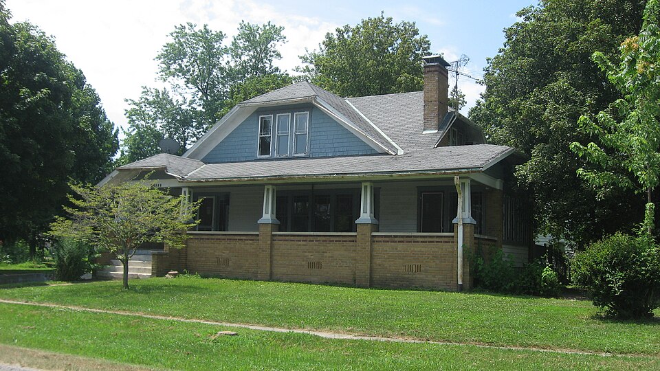
Photograph of Floyd and Glenora Dycus House
Photograph by Nyttend, Public domain. Via Wikimedia Commons.

Floyd and Glenora Dycus House

Listed on the National Register of Historic Places in 2001.

From the record

“The Floyd and Glenora Dycus House is a historic house located at 305 S. The house was built in 1926 for Floyd and Glenora Dycus.”

Wikipedia article Floyd and Glenora Dycus House, CC BY-SA 4.0.

One of 4 National Register listings published here for Fayette County · listed in 2001 · category: Building.

Sources: the Wikipedia article · the case file at the National Archives · the National Register database, National Park Service
The listing

  • What is counted as historic. The nomination lists 3 objectss, 2 buildingss as contributing to the listing.
  • Listed as. Dycus, Floyd and Glenora, House - the National Register files a house under its owner's surname.
  • Address. 305 S. Second St., Brownstown, 62418
  • When was it listed? March 2001
  • Category. building
  • Township. Otego township
  • National Register reference number. 01000179 - the number the National Park Service assigned this property when it was listed, and the key its nomination file is catalogued under at the National Archives.

The ground it stands on

5,541 words

The chapter on Otego Township in History of Fayette County, Illinois, published 1878 names Brownstown. This is what it says, exactly as the scans read.

The soil in the timber land is a red-colored clay, but in the prairie is a light grey-colored loam. About one-third of the township is prairie, part of which lays in the north-east around Brownstown, and the " four mile " which lays in the center of the township.

Passage source: History of Fayette County, Illinois, published 1878.

Isaac Washburn was the first resident physician; he lived in Section 23, and practiced first in 1837. Then came Simeon Bishop, who lived in Section 17, and practiced in 1838; then John F. Morey, who resided in Section 22, and who was the most prominent physician who had lived in the township. L. A. Morey, son of John F. Morey, is now practicing in Otego, and is living in Section 14. Dr. Noll and Dr. Sethman lived and practiced a short time in the township. Dr. Darnell and Dr. Stringer are the present resident physicians of Brownstown.

Passage source: History of Fayette County, Illinois, published 1878.

Machine-read from a century-old scan, so expect the errors a machine makes: misspelled names, dropped words, stray characters.

Read the whole chapter on Otego Township - 5,541 words on its settlement, mills, schools and churches.

Storms near this property

14 since 1994

Regional context, not property-specific evidence. The National Weather Service names Brownstown, the town this property stands in, in 14 storm reports between 1994 and 2020: 9 thunderstorm wind, 3 hail, 2 tornado. No death or injury is recorded in these reports. Each account below is quoted exactly as the forecast office filed it, from the NOAA Storm Events Database, and each date opens the federal record of that event.

WhenEvent Place namedHarm What the report says
April 1994Thunderstorm WindBrownstown$5,000Trees and power lines were blown down north of Brownstown while a barn and garage were heavily damaged in St. Peter.
August 2020Thunderstorm WindBrownstown-Thunderstorm gust front blew down several trees and power lines between Brownstown and St. Elmo.
August 2014Thunderstorm WindBrownstown-Thunderstorm winds blew a large tree limb down and blew an empty grain bin across a yard and onto a road.
February 2014Tornado (EF1)Brownstown-The tornado developed 2.8 miles northwest of Brownstown or 0.3 miles north of the intersection of County Roads 1900N and 1375E. One large old tree was down while several large branches along a row of trees were snapped two thirds up the trunk. The damage path was approximately 40 yards wide and damage intensity was rated EF0. Two witnesses observed the tornado near the intersection of County Roads 2000N and 1450E. The tornado was rain wrapped and skipped over this area. One large machine shed was damaged about 150 yards southwest of this intersection while the southern part of another barn southeast of the intersection was severely damaged. Debris from both structures were tossed about one third mile to the northeast. At the intersection of 2100N and 1600E three tall wooden transmission line poles were snapped two thirds up the pole at this intersection. Approximately 50 yards to the southeast of this intersection a medium size machine shed was severely damaged with the east and south sides of the shed shredded and tossed one third mile to the northeast. The tornado continued northeast and destroyed a large machine shed housing farm equipment. The tornado totally shredded the metal panels and tossed them over one third mile to the north. A medium size machine shed approximately one half mile to the northeast of the large machine shed lost a few metal roof panels. The tornado lifted and dissipated about 5.5 miles north northeast of Brownstown. The maximum intensity was EF1 with a maximum wind speed of 105 mph. The total path length was 4.8 miles with a maximum width 50 yards.
June 2009Thunderstorm WindBrownstown-Thunderstorm winds caused minor damage in the Brownstown area. Three miles west of Brownstown a few windows were blown out of a trailer. Just south of Brownstown several large tree limbs were blown down.
June 2008Thunderstorm WindBrownstown-Thunderstorm winds blew the roof off of a small shed in Brownstown and destroyed a small shed and 60 foot radio tower just north of St. Elmo.
March 2005HailBrownstown-Storm spotters reported 1 inch hail.
July 1997Thunderstorm WindBrownstown-The Illinois State Police reported trees down in the Brownstown area.
June 2009HailBrownstown-no account filed
January 2005Thunderstorm WindBrownstown-no account filed
June 2002Thunderstorm WindBrownstown-no account filed
June 1999Tornado (F2)Brownstown-no account filed
July 1998Thunderstorm WindBrownstown-no account filed
March 1997HailBrownstown-no account filed

Every storm recorded in Fayette County

Map coverage status

No historic map-sheet match is published for this property yet. That does not mean no map exists. This record needs a coordinate-quality review before it can be joined to a sheet boundary. Browse the county's mapped places while that work is pending.

Listed places nearby

1 within 8 miles

Other National Register properties close enough to walk or drive between, ordered by distance from this one. Both positions come from the same geocoding pass that matched these properties to their map sheets.

Photograph PropertyDistance Listed
First Presbyterian Church7.9 miles1982

Sources for this property

National Archives recordThe nomination case file for reference 01000179 in Record Group 79.
Wikipedia articleCommunity-written account of this property, licensed CC BY-SA.
Fayette CountyAll 4 listed properties in this county.

Provenance

  • Listing record. National Park Service National Register of Historic Places, listed-properties dataset, current to 2026-05-22.
  • Map join. Address geocoded through the United States Census geocoder, then tested against the published boundary of every sheet in the USGS Historical Topographic Map Collection.
  • How this page is made. Listing fields come from federal records; map-sheet coverage is a labelled coordinate-to-boundary calculation, not a source-field claim.
  • Storms. NOAA National Centers for Environmental Information, Storm Events Database https://www.ncei.noaa.gov/stormevents/ A work of the United States government, no copyright under 17 U.S.C. 105. Narratives are quoted verbatim from the National Weather Service report and are not edited or summarised.