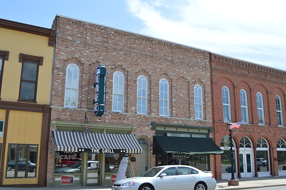
Listed on the National Register of Historic Places in 2004.
From the record
“The Downey Building is a historic building located at 110-112 Southwest Arch Street in Atlanta, Illinois. The Italianate building was constructed in 1867 by local businessman Alexander Downey.”
Wikipedia article Downey Building, CC BY-SA 4.0.
One of 12 National Register listings published here for Logan County · listed in 2004 · category: Building.
National Register reference number.04000069- the number the National Park Service assigned this property when it was listed, and the key its nomination file is catalogued under at the National Archives.
The early settlers of this part of the county, well remember the days of Abraham Lincola, David Davis, and others of like prominence, when on their horseback journeys to and from the various courts in the interior part of the state. When going from Springfield to Bloomington, these ' two named almost always stopped at the house of Samuel Hoblit, one of the earliest residents in this part of the county, which at that time and until 1845 was a portion of DeWitt County. At this date, Pekin was the chief market. Springfield was the first post-office for this locality ; afterward, Bloomington or Pekin, and almost co temporary the small town of Waynesville in DeWitt County, one of the oldest in this part of the state. ^ A demand for a nearer market and better shipping facilities was being felt, * and to aid in the hope for the fulfillment of these wants,, the survey of the Chicago & Alton Railroad was mttde. This road gave activity to these desires, and no sooner was the survey fixed than the location of a town in this section of the country was agitated. The town of M t. Hope, a few miles northeast of the site of Atlanta, was staked out, but being off the railroad was abandoned. It is now the farm of Marion McCormick. New Castle, to the southeast, l^ad become quite a village, but, for the same reason, was abandoned on the survey of Atlanta, and became incorporated therein, the majority of its residents moving to the new toWn. The Baptists had built a house of worship there, and some trade was established at this, date - 1853, Early in this year, R. T. Gill, then a resident of Pekin, entered the land on which the city of Atlanta now stands, at one dollar and twenty-five cents per acre. It was then assessed at twelve hundred dollars. The assessed value now is nearly a half million. On the 23d of June, he offered the lots At public auction, and by a liberal policy secured a large sale, and before the close of the season, fifteen or twenty buildings were ready for occupancy. The first of these was built , by R. T. Gill, and occupied the present site of a meat market, near the corner of Vine and Railroad streets. The freight house was erected by the railroad company about the same time, and shortly after a passenger dep5t.
When the town was surveyed, it received the name of Xenia. This name was suggested by Mrs. James Downey, in remembrance of her former home in Xenia, Ohio, ^n application for a post-office, it was ascertained that an office by that name already existed in the state, and the founders of the town changed it to Hamilton, in honor of Col. L. D. Hamilton. Applying the second time for a post-office, they met with the same difficulty, and to avoid having a town and post-office of different names, a third name was chosen. Mr. R. T. Gill had some time previously spent a portion of a year in Atlanta, Georgia, and remembering the beauty of that city, suggested that name. As no post-oMce of that name existed in Illinois, that appellation was adopted. Several persons yet hold deeds of lots in the town of Xenia.
Regional context, not property-specific
evidence. The
federal wildfire occurrence database
lists 1 fire within 5 miles of Downey Building
in 2012, burning about 3 acres in total. None started naturally. None was recorded as arson.
Distance is straight-line from the map coordinates, so a fire counted
here may appear on a neighbouring settlement's page as well.
Reported cause
Fires
Debris and open burning
1
The most recent of
them, most recent first, with the day each was reported and the service
that recorded it.
Regional context, not property-specific
evidence. The federal mineral resources record lists
2 workings within 5 miles of Downey Building: 1 producer, 1 past producer.
1 still produces. What was taken out: Sand and Gravel, Construction. Distance is straight-line from the
map coordinates, so a quarry counted here may appear on a neighbouring
settlement's page as well.
Regional context, not property-specific
evidence. The National Weather Service names
Atlanta, the town this property stands in, in 28 storm reports between 1995 and 2025: 13 thunderstorm wind, 9 hail, 4 tornado, 2 flash flood.
No death or injury is recorded in these reports. Each account below is quoted exactly as the forecast office
filed it, from the NOAA Storm Events Database, and each date
opens the federal record of that event.
Thunderstorms produced 5.00 to 8.00 of rainfall in northern Logan County during the evening hours. Flash flooding rapidly developed, which made many streets impassable in San Jose, Hartsburg and Atlanta. The biggest impacts were near the Logan/Tazewell County line where the water was three to four feet deep. A section of Canadian National Railroad tracks near U.S. Highway 136 and Emden were washed out. At least two water rescues had to be made for stranded motorists on roads near the county line. No injuries were reported.
Thunderstorm winds blew down a large tree onto a garage causing moderate roof damage. Also, the winds destroyed a tool shed and blew a few shingles off of the roof of a house.
Several large trees were blown down by thunderstorm winds estimated around 60 mph. One large tree was blown down on Highway 10 blocking both lanes near New Holland and another one fell onto a truck in Lincoln. No one was injured.
No historic map-sheet match is published
for this property yet. That does not mean no map exists. This record needs
a coordinate-quality review before it can be joined to a sheet boundary.
Browse the county's mapped places while that work is
pending.
Listed places nearby
2 within 8 miles
Other National Register properties close
enough to walk or drive between, ordered by distance from this one. Both
positions come from the same geocoding pass that matched these properties
to their map sheets.
Listing record. National Park Service National Register of Historic Places, listed-properties dataset, current to 2026-05-22.
Map join. Address geocoded through the United States Census geocoder, then tested against the published boundary of every sheet in the USGS Historical Topographic Map Collection.
How this page is made. Listing fields come from federal records; map-sheet coverage is a labelled coordinate-to-boundary calculation, not a source-field claim.
Wildfire. Short, Karen C. 2022. Spatial wildfire occurrence data for the United States, 1992-2020 [FPA_FOD_20221014]. 6th Edition. Fort Collins, CO: Forest Service Research Data Archive. https://doi.org/10.2737/RDS-2013-0009.6 Collected with United States Government funding and usable without additional permissions or fees.
Mines and quarries. USGS Mineral Resources Data System (MRDS) https://mrdata.usgs.gov/mrds/ A work of the United States government, no copyright under 17 U.S.C. 105.
Storms. NOAA National Centers for Environmental Information, Storm Events Database https://www.ncei.noaa.gov/stormevents/ A work of the United States government, no copyright under 17 U.S.C. 105. Narratives are quoted verbatim from the National Weather Service report and are not edited or summarised.
 Block