
BlockBefore
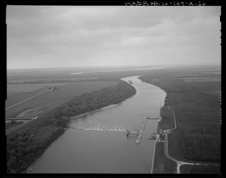
Photograph of La Grange Lock and Dam
Photograph by Brian Grogan, Public domain. Via Wikimedia Commons.

La Grange Lock and Dam Historic District

Listed on the National Register of Historic Places in 2004.

From the record

One of 2 National Register listings published here for Brown County · listed in 2004 · category: District.

Sources: the case file at the National Archives · the National Register database, National Park Service · the Wikipedia article

The listing

  • Address. 0.75 mi. S of Cty Rte 795N at Illinois River, Versailles, 62378
  • When was it listed? March 2004
  • Category. district
  • Also known as. Illinois Waterway Navigation System Facilities MPS
  • Township. Cooperstown township
  • National Register reference number. 04000170 - the number the National Park Service assigned this property when it was listed, and the key its nomination file is catalogued under at the National Archives.

Storms near this property

21 since 1995

Regional context, not property-specific evidence. The National Weather Service names Versailles, the town this property stands in, in 21 storm reports between 1995 and 2026: 10 thunderstorm wind, 10 hail, 1 tornado. The reports record 1 injury. Each account below is quoted exactly as the forecast office filed it, from the NOAA Storm Events Database, and each date opens the federal record of that event.

WhenEvent Place namedHarm What the report says
February 2017Tornado (EF1)Versailles1 hurtThe tornado first touched down on the far west side of Versailles where it caused minor tree damage. The tornado traveled northeast and impacted a house which sustained roof damage. On the other side of the road, two single wide mobile home trailers were overturned. Damage at this location was rated high end EF1. Farther to the northeast, more substantial tree damage occurred. Several mature trees were topped, split and snapped at various heights above the ground. The surrounding structures sustained corresponding roof, siding and fascia damage. Damage was also rated high end EF1 along this portion of the track. The tornado continued northeast and crossed Illinois Route 99 and caused additional minor tree damage. The tornado moved northeast through the far northeast portion of town causing additional EF0 tree, roof and fascia damage to structures. The tornado dissipated as it moved out of the northeast corner of Versailles. Overall, the tornado was rated EF1 with a path length of 0.66 miles and a maximum path width of 50 yards.
June 2024Thunderstorm WindVersailles$30,000The Brown County emergency manager reported power poles and trees down over the north side of Versailles.
May 2022Thunderstorm WindVersailles$2,000A twelve inch diameter maple tree top was snapped off.
April 2026Thunderstorm WindVersailles-Thunderstorm winds heavily damaged a machine shed in the bottoms of the Illinois River southeast of Versailles. Winds also knocked a tree onto a mobile home in Versailles around the same time.
June 2023Thunderstorm WindVersailles-Thunderstorm winds blew down several trees in and around Versailles.
May 2018Thunderstorm WindVersailles-Thunderstorm winds blew down two large trees in town.
July 2016Thunderstorm WindVersailles-Thunderstorm winds blew down at least 6 trees along Illinois Route 99 from Versailles southeastward towards the Brown/Pike County line.
May 2011Thunderstorm WindVersailles-Thunderstorm winds blew the roof off of an outbuilding near the intersection of Illinois Route 99 and County Road 1300E. Also, three power poles were snapped off and power lines knocked down.
June 2009Thunderstorm WindVersailles-Several trees were blown down in Versailles.
September 2005HailVersailles-The public reported 1 inch hail west southwest of Versailles.
June 2002Thunderstorm WindVersailles-Thunderstorm wind gusts downed trees and power lines.
June 1995Thunderstorm WindVersailles-The county sheriff reported large tree limbs blown down.
December 2018HailVersailles-no account filed
June 2014HailVersailles-no account filed
October 2013HailVersailles-no account filed
May 2009HailVersailles-no account filed
March 2006HailVersailles-no account filed
April 2001HailVersailles-no account filed
October 1998HailVersailles-no account filed
May 1998HailVersailles-no account filed
October 1998HailVersailles-no account filed

Every storm recorded in Brown County

Map coverage status

No historic map-sheet match is published for this property yet. That does not mean no map exists. This record needs a coordinate-quality review before it can be joined to a sheet boundary. Browse the county's mapped places while that work is pending.

Sources for this property

National Archives recordThe nomination case file for reference 04000170 in Record Group 79.
Wikipedia articleCommunity-written account of this property, licensed CC BY-SA.
Brown CountyAll 2 listed properties in this county.

Provenance

  • Listing record. National Park Service National Register of Historic Places, listed-properties dataset, current to 2026-05-22.
  • Map join. Address geocoded through the United States Census geocoder, then tested against the published boundary of every sheet in the USGS Historical Topographic Map Collection.
  • How this page is made. Listing fields come from federal records; map-sheet coverage is a labelled coordinate-to-boundary calculation, not a source-field claim.
  • Storms. NOAA National Centers for Environmental Information, Storm Events Database https://www.ncei.noaa.gov/stormevents/ A work of the United States government, no copyright under 17 U.S.C. 105. Narratives are quoted verbatim from the National Weather Service report and are not edited or summarised.