BlockBefore
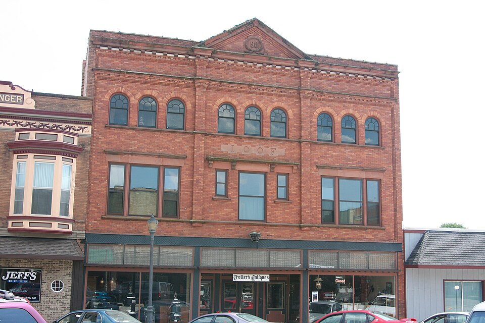
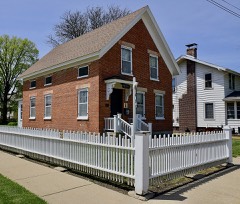
Photograph of Polo Independent Order of Odd Fellows Lodge No. 197
Photograph by Ben Jacobson ( Kranar Drogin ), CC BY 2.5. Via Wikimedia Commons.

Polo Independent Order of Odd Fellows Lodge No. 197

Listed on the National Register of Historic Places in 2004.

From the record

“Polo Independent Order of Odd Fellows Lodge No. 197 is a historic Independent Order of Odd Fellows building located at 117 W. The lodge was built in 1901-02 for Polo's chapter of the Odd Fellows, which was established in 1856; it was the fifth meeting place used by the chapter.”

Wikipedia article Polo Independent Order of Odd Fellows Lodge No. 197, CC BY-SA 4.0.

One of 29 National Register listings published here for Ogle County · listed in 2004 · category: Building.

Sources: the Wikipedia article · the case file at the National Archives · the National Register database, National Park Service
The listing

  • What is counted as historic. The nomination lists 1 building as contributing to the listing.
  • Address. 117 W. Mason St., Polo, 61064
  • When was it listed? December 2004
  • Category. building
  • Township. Buffalo township
  • Architectural style. Neoclassical architecture
  • National Register reference number. 04001302 - the number the National Park Service assigned this property when it was listed, and the key its nomination file is catalogued under at the National Archives.

What happened here

An account from the chapter on Buffalo township. The inset identifies its exact source book and publication year.

From The History of Ogle County, Illinois, Containing a History of the County, Its Cities, Towns, Etc., a Biographical Directory of Its Citizens, War Record of Its Volunteers in the Late Rebellion, General and Local Statistics ... History of the Northwest, History of Illinois ... Etc, published 1878 - Buffalo Township

Kauffman Benjamin

Farmer ; Sec. 24 ; P. 0. Polo ; son of John and Martha Kauffman ; born in Huntingdon Co., Pa., March 14, 1840 ; in Sept., 1861, he enlisted in Co. H. 87th Pa. Y. I. ; served three years ; wounded and taken prisoner at the battle of Bunker Hill, Va., June 13. 1863; was prisoner 108 days at Belle Isle, Richmond ; when he was paroled he went to Annapolis, and rejoined his regiment at Brandy Station ; was in the battles of the Wilderness, Cold Harbor and all the principal engagements of the Army of the Potomac under General Grant, until July 6, 1864 ; from Petersburg he then went to Baltimore and Frederick City; was at the battle of Monocacy Junction, July 9, 1864; after being stationed at various places, was in the battles under Gen.

Read the rest of this passage

The ground it stands on

24,245 words

The chapter on Buffalo Township in The History of Ogle County, Illinois, Containing a History of the County, Its Cities, Towns, Etc., a Biographical Directory of Its Citizens, War Record of Its Volunteers in the Late Rebellion, General and Local Statistics ... History of the Northwest, History of Illinois ... Etc, published 1878 names Polo. This is what it says, exactly as the scans read.

AI.DRICII TILSON, Druggist and dealer in Paints, Oils, Fancy Goods, etc.. Mason st. near Railroad ; residence, corner Division and Dixon sts.; born in Douglass, Worcester Co., Mass., June 6, 1816 ; came to Elkhorn Grove, Carroll Co., in the Spring of 1839 ; during his residence there, he was for twenty years Postmaster, Supervisor three terms, Township School Treasurer, etc.; came to Polo in 1868; engaged in the drug business ever since he came here ; a portion of the time dealing in leather also ; he was one of the incorporators of the Polo Harvester Co., and is President of the Company now ; Mr. A. married Hepsibah Morgan in 1837 ; she was born in Canton, Hartford Co., Conn.; i they have one child living ; one son, Myron, died at the age of three years ; Mr. and Mrs. A. are Congregationalists.

Passage source: The History of Ogle County, Illinois, Containing a History of the County, Its Cities, Towns, Etc., a Biographical Directory of Its Citizens, War Record of Its Volunteers in the Late Rebellion, General and Local Statistics ... History of the Northwest, History of Illinois ... Etc, published 1878.

AXDERSOX AROIiD T. Farmer and Stock Raiser ; Polo ; son of George A., of Virginia, and Elizabeth Freeman, of New Jersey ; was born in Crawford Co., Pa., in 1825 ; came to Buffalo Grove in the Spring of 1848 ; commenced farming on forty acres, on Sec. 22 ; at the present time, he has the following real estate : 320 acres on Sec. 27, 160 acres on Sec. 3, 320 acres on Sec. 20, 280 acres on Sec. 26, besides 1,120 acres in Lee Co., 111.; has dealt in stock extensively; commenced the

Passage source: The History of Ogle County, Illinois, Containing a History of the County, Its Cities, Towns, Etc., a Biographical Directory of Its Citizens, War Record of Its Volunteers in the Late Rebellion, General and Local Statistics ... History of the Northwest, History of Illinois ... Etc, published 1878.

Machine-read from a century-old scan, so expect the errors a machine makes: misspelled names, dropped words, stray characters.

Read the whole chapter on Buffalo Township - 24,245 words on its settlement, mills, schools and churches.

Mines and quarries near this property

7 within 5 miles

Regional context, not property-specific evidence. The federal mineral resources record lists 7 workings within 5 miles of Polo Independent Order of Odd Fellows Lodge No. 197: 6 past producers, 1 producer. 1 still produces. What was taken out: Stone, Crushed/Broken, Limestone, General. Distance is straight-line from the map coordinates, so a quarry counted here may appear on a neighbouring settlement's page as well.

Where SiteCommodity StatusRecorded
Pine Creek RockLimestone, GeneralPast Producer
Ed Schnulle QuarryStone, Crushed/BrokenPast Producer
Graehling QuarryStone, Crushed/BrokenPast Producer
Reid QuarryStone, Crushed/BrokenProducer
Unnamed Limestone QuarryStone, Crushed/BrokenPast Producer

Every working recorded in Ogle County

Storms near this property

55 since 1994

Regional context, not property-specific evidence. The National Weather Service names Polo, the town this property stands in, in 55 storm reports between 1994 and 2026: 35 thunderstorm wind, 15 hail, 2 flash flood, 1 flood. No death or injury is recorded in these reports. Each account below is quoted exactly as the forecast office filed it, from the NOAA Storm Events Database, and each date opens the federal record of that event.

WhenEvent Place namedHarm What the report says
July 2007Thunderstorm WindPolo$50,000Numerous large tree limbs blown down, some on houses. Damage to sheds, signs and siding.
July 2002Thunderstorm WindPolo$5,000no account filed
August 2007Thunderstorm WindPolo$2,000Trees blown down onto power lines.
August 2010Thunderstorm WindPolo$1,000A four inch diameter tree was snapped at its base. Power lines were blown down.
March 2026HailPolo-Most of the hail that fell was one half inch in diameter but the largest hail stones were ping pong ball size.
March 2025Thunderstorm WindPolo-Large tree limbs and branches were reported down in Polo.
June 2025Heavy RainPolo-A personal weather station recorded 1.21 in just under an hour in Polo.
June 2024Thunderstorm WindPolo-A few 3 to 5 inch diameter tree limbs were downed in Polo.
July 2023Thunderstorm WindPolo-Several large tree limbs and branches were reported down across Polo. Wind speed was estimated using radar.
July 2022HailPolo-A photo shared on social media showed quarter size hail.
July 2022Thunderstorm WindPolo-Several 3 inch diameter tree limbs were blown down in Polo, along with one 20 foot long, 6 inch diameter tree limb.
August 2022Thunderstorm WindPolo-A 5 inch diameter, 15 foot long tree limb was blown down. Numerous other tree limbs were blown down.
August 2021Thunderstorm WindPolo-A tree was blown down onto a house.
July 2016Thunderstorm WindPolo-Old shed knocked down, with a portion of an old barn damaged and branches downed. Radar estimated time.
July 2014Thunderstorm WindPolo-A large tree branch was blown down onto a road near Polo.
May 2013Thunderstorm WindPolo-Trees and wires were blown down.
July 2012Thunderstorm WindPolo-Three to four trees were blown down with numerous tree limbs blown down. One soft wood maple tree one foot in diameter had its top twisted off, ten to twelve feet above the ground.
August 2012Thunderstorm WindPolo-Tree limbs 6 to 8 inches in diameter were blown down.
July 2011Thunderstorm WindPolo-Corn fields were flattened, and 6-inch diameter branches were blown down along with power lines.
April 2010Thunderstorm WindPolo-Trees were blown down just west of Polo.
April 2008HailPolo-Nickel size hail was reported along Division Street.
July 2008Thunderstorm WindPolo-A seven inch diameter tree limb was blown down. Numerous small limbs were also blown down.
August 2008Thunderstorm WindPolo-Tree limbs as large as eight inches in diameter were blown down.
July 2007Flash FloodPolo-Pine Creek overflowed its banks in White Pines State Park. Polo measured 4.27 inches of rain.
July 2007Thunderstorm WindPolo-Large tree limbs blown down near the entrance of White Pines State Park.
March 2007HailPolo-Marble to Nickle size hail reported along Route 26 and US 52.
August 2007Thunderstorm WindPolo-Eight inch diameter tree limbs blown down.
July 2007Flash FloodPolo-Division and West Coven Streets flooded. Polo measured 4.74 inches and 3 miles south of Oregon measured 5.19 inches.
July 2006Thunderstorm WindPolo-Three to four inch tree limbs blown down.
July 2006Thunderstorm WindPolo-Trees were blown down.
August 2006Thunderstorm WindPolo-Trees blown down near the intersection of Hickory and Penn Roads.
September 2005Thunderstorm WindPolo-Large tree limbs were blown down, one fell on two cars.
September 2001FloodPolo-1.25 inches of rain fell in 30 minutes and caused some street flooding and minor flooding in a few basements.
June 1999Thunderstorm WindPolo-A shed was damaged and tree limbs were blown down.
May 1998Thunderstorm WindPolo-Strong winds downed trees.
June 1994Thunderstorm WindPolo-The County sheriff reported that trees were blown down.
April 2023HailPolo-no account filed
July 2023Thunderstorm WindPolo-no account filed
May 2020Funnel CloudPolo-no account filed
May 2014HailPolo-no account filed
July 2012HailPolo-no account filed
May 2011HailPolo-no account filed
June 2011HailPolo-no account filed
June 2009HailPolo-no account filed
March 2005HailPolo-no account filed
July 2004HailPolo-no account filed
April 2003HailPolo-no account filed
July 2003Thunderstorm WindPolo-no account filed
September 2000Thunderstorm WindPolo-no account filed
April 1997Thunderstorm WindPolo-no account filed
June 1996Thunderstorm WindPolo-no account filed
April 1996Thunderstorm WindPolo-no account filed
June 1995HailPolo-no account filed

Every storm recorded in Ogle County

Map coverage status

No historic map-sheet match is published for this property yet. That does not mean no map exists. This record needs a coordinate-quality review before it can be joined to a sheet boundary. Browse the county's mapped places while that work is pending.

Listed places nearby

6 within 8 miles

Other National Register properties close enough to walk or drive between, ordered by distance from this one. Both positions come from the same geocoding pass that matched these properties to their map sheets.

Photograph PropertyDistance Listed
Dr. William Burns Houseunder 500 feet2018
Zenas Aplington House0.1 miles2017
Buffalo Township Public Library0.1 miles1995
Bryant H. and Lucie Barber House0.2 miles1993
David and Julia Watson House0.3 miles2017
John McGrath House0.8 miles1996

Sources for this property

National Archives recordThe nomination case file for reference 04001302 in Record Group 79.
Wikipedia articleCommunity-written account of this property, licensed CC BY-SA.
Ogle CountyAll 29 listed properties in this county.

Provenance

  • Listing record. National Park Service National Register of Historic Places, listed-properties dataset, current to 2026-05-22.
  • Map join. Address geocoded through the United States Census geocoder, then tested against the published boundary of every sheet in the USGS Historical Topographic Map Collection.
  • How this page is made. Listing fields come from federal records; map-sheet coverage is a labelled coordinate-to-boundary calculation, not a source-field claim.
  • Mines and quarries. USGS Mineral Resources Data System (MRDS) https://mrdata.usgs.gov/mrds/ A work of the United States government, no copyright under 17 U.S.C. 105.
  • Storms. NOAA National Centers for Environmental Information, Storm Events Database https://www.ncei.noaa.gov/stormevents/ A work of the United States government, no copyright under 17 U.S.C. 105. Narratives are quoted verbatim from the National Weather Service report and are not edited or summarised.