BlockBefore
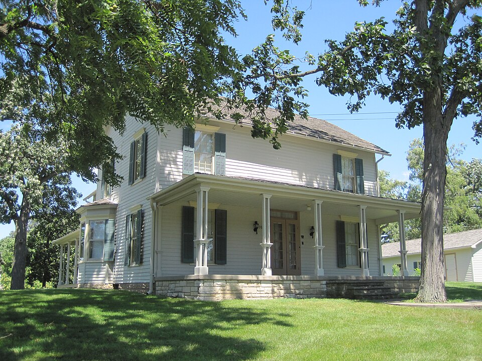
Photograph of John Humphrey House
Photograph by Teemu08 at en.wikipedia, CC BY-SA 3.0. Via Wikimedia Commons.

John Humphrey House

Listed on the National Register of Historic Places in 2005.

From the record

“The John Humphrey House is a historic home in Orland Park, Illinois. It was listed on the National Register of Historic Places in 2005.”

Wikipedia article John Humphrey House (Orland Park, Illinois), CC BY-SA 4.0.

One of 621 National Register listings published here for Cook County · listed in 2005 · category: Building.

Sources: the Wikipedia article · the case file at the National Archives · the National Register database, National Park Service · the Wikipedia article

The listing

  • What is counted as historic. The nomination lists 2 buildingss as contributing to the listing.
  • Listed as. Humphrey, John, House - the National Register files a house under its owner's surname.
  • Address. 9830 W. 144th Place, Orland Park, 60462
  • When was it listed? August 2005
  • Category. building
  • Township. Orland township
  • National Register reference number. 05000114 - the number the National Park Service assigned this property when it was listed, and the key its nomination file is catalogued under at the National Archives.

Storms near this property

35 since 1996

Regional context, not property-specific evidence. The National Weather Service names Orland Park, the town this property stands in, in 35 storm reports between 1996 and 2026: 13 hail, 11 thunderstorm wind, 5 flood, 3 flash flood. No death or injury is recorded in these reports. Each account below is quoted exactly as the forecast office filed it, from the NOAA Storm Events Database, and each date opens the federal record of that event.

WhenEvent Place namedHarm What the report says
August 2008Thunderstorm WindOrland Park$50,000A microburst began near the railroad tracks just east of Southwest Highway about one quarter mile south of 135th Street. The microburst widened, causing a damage path one quarter mile wide and about one third mile long. The microburst blew down numerous trees in the area of Carolina Lane, 92nd Avenue, Elm Street, and 137th and 138th Streets. Trees fell on rooftops, shingles were blown off a shed, there was damage to eaves of homes and there was porch and eave damage due to falling trees and tree limbs. Power lines were also downed due to falling tree limbs.
August 2008Tornado (EF0)Orland Park$30,000A tornado touched down along the south side of 135th Street, one block east of LaGrange Road. It moved southeast through the neighborhood along Howe Drive snapping off numerous tree tops, downing three or four large trees, blowing down a fence, sending a gazebo swirling 30 feet into the air before depositing it in a neighbor's yard and damaging a roof on an auto shop along Southwest Highway. A car was also damaged by a falling tree limb. At this point, the weakening tornado was wiped out by a microburst as it crossed the railroad trucks just east of Southwest Highway about a quarter mile south of 135th Street.
April 2025FloodOrland Park-A few reports of street flooding were received from the Orland Park and Oak Forest areas.
May 2024FloodOrland Park-Street flooding was reported.
July 2024Thunderstorm WindOrland Park-An 8 inch diameter tree limb was broken.
September 2023Thunderstorm WindOrland Park-A wind gust to 60 mph was measured.
May 2020Flash FloodOrland Park-Will-Cook Road was closed between 151st Street and 159th Street due to flooding.
August 2020Thunderstorm WindOrland Park-Tree limbs and power lines were blown down in Orland Park. A fence was damaged in the Catalina subdivision.
April 2020FloodOrland Park-Flooding caused 143rd Street to be closed west of Wolf Road.
April 2020FloodOrland Park-A low lying area of Route 7 was closed near Route 45 due to flooding.
May 2019FloodOrland Park-Wolf Road was closed due to flooding between 151st and 143rd Streets.
April 2011HailOrland Park-Penny size hail was reported in Orland Park.
August 2007Thunderstorm WindOrland Park-Estimated gust to 65 mph.
July 2006Funnel CloudOrland Park-A funnel cloud was reported near 179th and Lagrange Road.
July 2006Flash FloodOrland Park-Cars had to be pushed out of deep standing flood waters.
March 2005HailOrland Park-Penny sized hail was reported in Orland Park at the intersection of 82nd Ave. and 143rd St, 1830-1835 CST.Nickel sized hail was reported in Chicago Ridge, 1830-1830 CST.Nickel sized hail was reported in Oak Lawn at the intersection of 115th St. and Central Ave., 1832-1837 CST.Penny sized hail was reported in Bridgeview, 1835-1840 CST.Nickel sized hail was reported in Evergreen Park, 1843-1848 CST.
June 2004Flash FloodOrland Park-Three feet of water was reported on 104th Avenue and 159th Street.
September 1998Thunderstorm WindOrland Park-A 60 mph wind gust was recorded on an anemometer.
September 1998Thunderstorm WindOrland Park-Thunderstorm winds caused damage around the intersection of Wolf Road and 159th Street. Two stoplights were blown down and 3 power poles were snapped. There was extensive tree damage in a two block area mainly northwest of the intersection. Slate shingles from an old historic schoolhouse on 159th were blown across the road. Some of the shingles broke windows or became inbedded in a truck and van. A bank building also had some roof damage and a metal pole building northeast of the intersection was damaged.
May 1997Thunderstorm WindOrland Park-Strong winds caused roof and tree damage to homes or businesses in Orland Park, Country Club HIlls and Tinley Park. A wind gust of 65 mph was reported at Orland Park. A 58 mph wind gust was recorded at the Lansing, IL AWOS. A very intense downburst or possibly a gustnado produced F0-F1 intensity damage for about a 2 mile long and 50 yard wide path through Lynwood, from Stoney Island Road to Burnham Road, parallel to and about 1/2 mile north of Glenwood-Dyer Road. Several businesses had roof damage west of Lynwood. In a subdivision in Lynwood about 30 homes sustained some damage. Mostly shingles removed, antennas down, windows broken, tree limbs down, gutters and awnings damages. Two houses at Lakewood and 201st had about half the roof torn of, a church had roof damage and a bell tower damaged. About half dozen other houses had small sections of the roof peeled off.
March 2026HailOrland Park-no account filed
May 2024HailOrland Park-no account filed
February 2017HailOrland Park-no account filed
July 2015HailOrland Park-no account filed
June 2012HailOrland Park-no account filed
May 2006HailOrland Park-no account filed
May 2003LightningOrland Park-no account filed
July 2003Thunderstorm WindOrland Park-no account filed
July 2001Thunderstorm WindOrland Park-no account filed
May 2000Thunderstorm WindOrland Park-no account filed
May 1997HailOrland Park-no account filed
April 1996HailOrland Park-no account filed

Every storm recorded in Cook County

Map coverage status

No historic map-sheet match is published for this property yet. That does not mean no map exists. This record needs a coordinate-quality review before it can be joined to a sheet boundary. Browse the county's mapped places while that work is pending.

Listed places nearby

6 within 8 miles

Other National Register properties close enough to walk or drive between, ordered by distance from this one. Both positions come from the same geocoding pass that matched these properties to their map sheets.

Sources for this property

National Archives recordThe nomination case file for reference 05000114 in Record Group 79.
Wikipedia articleCommunity-written account of this property, licensed CC BY-SA.
Cook CountyAll 621 listed properties in this county.

Provenance

  • Listing record. National Park Service National Register of Historic Places, listed-properties dataset, current to 2026-05-22.
  • Map join. Address geocoded through the United States Census geocoder, then tested against the published boundary of every sheet in the USGS Historical Topographic Map Collection.
  • How this page is made. Listing fields come from federal records; map-sheet coverage is a labelled coordinate-to-boundary calculation, not a source-field claim.
  • Storms. NOAA National Centers for Environmental Information, Storm Events Database https://www.ncei.noaa.gov/stormevents/ A work of the United States government, no copyright under 17 U.S.C. 105. Narratives are quoted verbatim from the National Weather Service report and are not edited or summarised.