BlockBefore
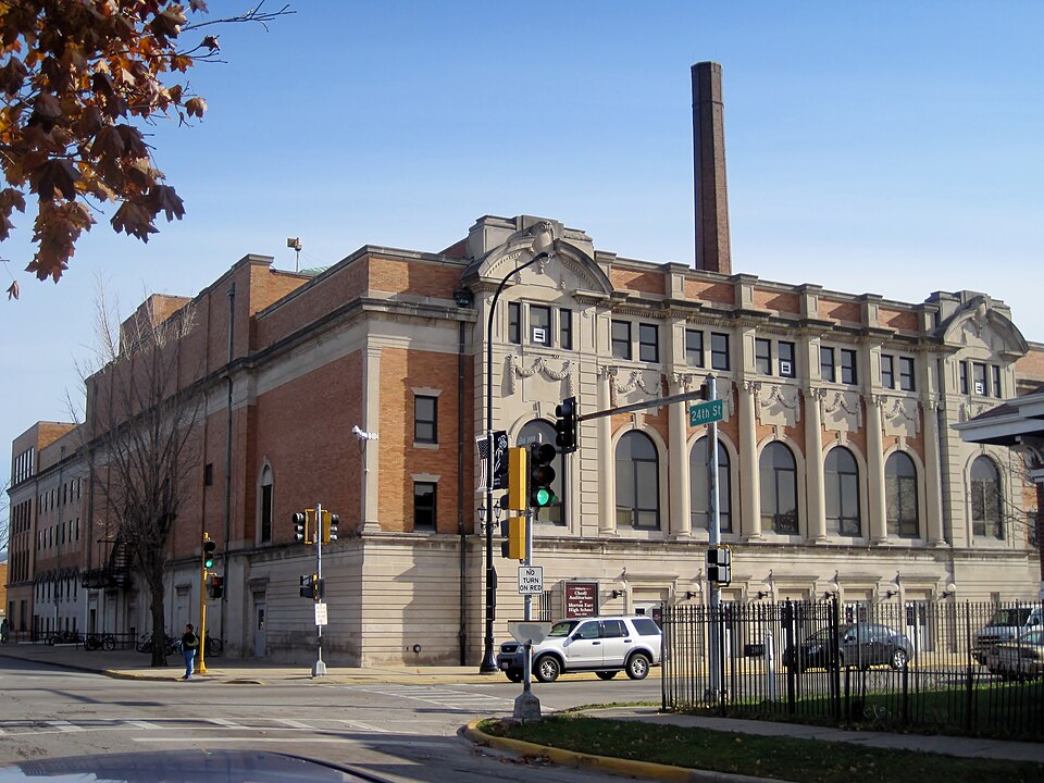
Photograph of J. Sterling Morton High School East Auditorium
Photograph by Teemu08, CC BY-SA 3.0. Via Wikimedia Commons.

J. Sterling Morton High School East Auditorium

Listed on the National Register of Historic Places in 1983.

From the record

“Sterling Morton High School East Auditorium, also known as Chodl Auditorium, is a Beaux-Arts building in Cicero, Illinois that was built in 1925 for J. It was listed on the National Register of Historic Places in 1983.”

Wikipedia article J. Sterling Morton High School East Auditorium, CC BY-SA 4.0.

One of 621 National Register listings published here for Cook County · listed in 1983 · category: Building.

Sources: the Wikipedia article · the case file at the National Archives · the National Register database, National Park Service

The listing

  • What is counted as historic. The nomination lists 1 building as contributing to the listing.
  • Listed as. Morton, J. Sterling, High School East Auditorium - the National Register files a house under its owner's surname.
  • Address. 2423 S. Austin Blvd., Cicero, 60804
  • When was it listed? May 1983
  • Category. building
  • Township. Cicero township
  • Architectural style. Beaux-Arts
  • National Register reference number. 83000312 - the number the National Park Service assigned this property when it was listed, and the key its nomination file is catalogued under at the National Archives.

Mines and quarries near this property

3 within 5 miles

Regional context, not property-specific evidence. The federal mineral resources record lists 3 workings within 5 miles of J. Sterling Morton High School East Auditorium: 3 past producers. None of them still produces. What was taken out: Stone, Crushed/Broken. Distance is straight-line from the map coordinates, so a quarry counted here may appear on a neighbouring settlement's page as well.

Where SiteCommodity StatusRecorded
River Forest City Eng - Own CrewsStone, Crushed/BrokenPast Producer
Riverside Lime and Stone Co QuarryStone, Crushed/BrokenPast Producer
Summit Quarry Consumers CompanyStone, Crushed/BrokenPast Producer

Every working recorded in Cook County

Storms near this property

21 since 1995

Regional context, not property-specific evidence. The National Weather Service names Cicero, the town this property stands in, in 21 storm reports between 1995 and 2026: 9 hail, 5 thunderstorm wind, 3 flood, 2 flash flood. No death or injury is recorded in these reports. Each account below is quoted exactly as the forecast office filed it, from the NOAA Storm Events Database, and each date opens the federal record of that event.

WhenEvent Place namedHarm What the report says
July 2025Flash FloodCicero$400,000Street and viaduct flooding were reported in numerous areas in central Chicago generally between Interstate 55 to the south, North Avenue to the north and Cicero Avenue to the west. Water rescues were reported at Western Avenue and Ogden Avenue and at Kinzie Street and Ashland Avenue. At least two viaducts were flooded in North Lawndale and a car was stalled in flood waters on Roosevelt Road just east of California Avenue. The local lanes of Interstate 90 were closed due to flooding between 18th Street and 31st Street. In Garfield Park, a car was submerged in flood waters on West Fulton Street; At least 3 garages were flooded with flood waters rushing like a river down an alley and multiple basements were flooded. Near the Chicago Loop, street flooding was reported along with a viaduct flooded and a photo showed a few inches of standing water at Hubbard's Cave on Interstate 90/94. An estimated 200 basements were flooded in the Near West Side. Street flooding was reported in West Town along with a few basements flooded. In Cicero, a few inches of standing water were reported on streets and sidewalks.||An automated rain gauge east of Garfield Park reported 5.12 inches of rain in 90 minutes from 19:55 CST to 21:25 CST with a storm total of 5.45 inches. A personal weather station west of the Loop reported 3.81 inches in about 2 hours at 21:43 CST.
June 2023Thunderstorm WindCicero-A tree was blown down near 28th Street and Austin Blvd.
June 2023Thunderstorm WindCicero-A tree and a utility pole were blown down onto a car.
July 2023Heavy RainCicero-A USGS rain gauge at Cicero recorded 8.6 inches of storm total rainfall.
June 2021Flash FloodCicero-Several streets were flooded in Cicero.
July 2019FloodCicero-Up to one foot of water was covering all lanes of Interstate 55 near Pulaski Road.
August 2016Tornado (EF0)Cicero-FAA contract observer for Midway Airport spotted a landspout tornado that formed on the lake breeze.
May 2013FloodCicero-High standing water was reported on southbound Interstate 55 at Pulaski Road.
June 2009Thunderstorm WindCicero-Trees were blown down.
June 2008Thunderstorm WindCicero-Wind gusts were estimated to 65 mph in Cicero.
August 2008Thunderstorm WindCicero-Wind gusts were estimated to 60 mph.
March 2026HailCicero-no account filed
June 2008HailCicero-no account filed
August 2008HailCicero-no account filed
May 2006HailCicero-no account filed
June 2005HailCicero-no account filed
July 2003HailCicero-no account filed
August 2003HailCicero-no account filed
August 1995HailCicero-no account filed

Every storm recorded in Cook County

Map coverage status

No historic map-sheet match is published for this property yet. That does not mean no map exists. This record needs a coordinate-quality review before it can be joined to a sheet boundary. Browse the county's mapped places while that work is pending.

Listed places nearby

6 within 8 miles

Other National Register properties close enough to walk or drive between, ordered by distance from this one. Both positions come from the same geocoding pass that matched these properties to their map sheets.

Photograph PropertyDistance Listed
Berwyn Health Center0.8 miles2002
Central Berwyn Bungalow Historic District1.0 miles2015
Berwyn Municipal Building1.0 miles2001
American State Bank1.1 miles2000
The Hunt Club1.5 miles2024
Mr. Robert Silhan House1.6 miles2007

Sources for this property

National Archives recordThe nomination case file for reference 83000312 in Record Group 79.
Wikipedia articleCommunity-written account of this property, licensed CC BY-SA.
Cook CountyAll 621 listed properties in this county.

Provenance

  • Listing record. National Park Service National Register of Historic Places, listed-properties dataset, current to 2026-05-22.
  • Map join. Address geocoded through the United States Census geocoder, then tested against the published boundary of every sheet in the USGS Historical Topographic Map Collection.
  • How this page is made. Listing fields come from federal records; map-sheet coverage is a labelled coordinate-to-boundary calculation, not a source-field claim.
  • Mines and quarries. USGS Mineral Resources Data System (MRDS) https://mrdata.usgs.gov/mrds/ A work of the United States government, no copyright under 17 U.S.C. 105.
  • Storms. NOAA National Centers for Environmental Information, Storm Events Database https://www.ncei.noaa.gov/stormevents/ A work of the United States government, no copyright under 17 U.S.C. 105. Narratives are quoted verbatim from the National Weather Service report and are not edited or summarised.