
BlockBefore
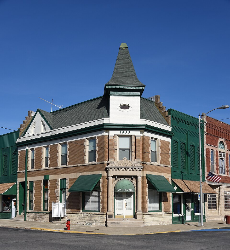
Photograph of Illinois State Bank Building
Photograph by Boscophotos, CC BY-SA 3.0. Via Wikimedia Commons.

Illinois State Bank Building

Listed on the National Register of Historic Places in 1984.

From the record

“The Illinois State Bank Building is a historic bank building located at 201 N. The building was constructed in 1900 to replace the Illinois State Bank's previous building, an 1883 structure which burned down in 1899.”

Wikipedia article Illinois State Bank Building, CC BY-SA 4.0.

One of 5 National Register listings published here for Christian County · listed in 1984 · category: Building.

Sources: the Wikipedia article · the case file at the National Archives · the National Register database, National Park Service

The listing

  • What is counted as historic. The nomination lists 1 building as contributing to the listing.
  • Address. 201 N. Chestnut St., Assumption, 62510
  • When was it listed? August 1984
  • Category. building
  • Township. Assumption township
  • National Register reference number. 84000923 - the number the National Park Service assigned this property when it was listed, and the key its nomination file is catalogued under at the National Archives.

What happened here

An account from the chapter on Assumption township. The inset identifies its exact source book and publication year.

From History of Christian County, Illinois, published 1880 - Assumption Township

Robert A. Hazlett

Ha/.lett, grandtather of Mr. Hazlett, came from Irelaud and settled in North Carolina before the Revolutionary war. Chandler Hazlett, his grandfather's brother, was a soldier in the Revolution. He was wounded at the battle of Bunker Hill, and there is still pres'erved in the family a book which he picked up as he crawled off that hotly contested field.

Read the rest of this passage

The ground it stands on

35,922 words

The chapter on Assumption Township in History of Christian County, Illinois, published 1880 names Assumption. This is what it says, exactly as the scans read.

After a time, Elsie E. Malhiot, having purchased most of the lands in the vicinity, laid out an addition on the south-west part of the town, with suitable streets, a public square, market place, grounds for church purposes, the " A.-suniption cemetery," Catholic cemetery - which he named Assumption, after his own plantatiem in Louisiana, virtually making but one town, though having two name.s. Taeusa was first surveyed by C. A. Manners, Kov. 1 , 1865, including the addition, and the name was changed to Assun)]itiou. The Canadian colonists, in 1857, mo.sth' settled in Malhiot's addition, and the town began to assume greater proportions. They erected twenty or thirty dwelling houses, a large three-story storehouse, a warehouse, a blacksmith shop and other buildings.

Passage source: History of Christian County, Illinois, published 1880.

For some fifteen years after the location of the station Assumj>- tion was a point fir the shipment of all the goods and produce to and from Taylorville. It was the nearest station, and was fourteen miles distant. Large consignments of goods for Taylorville were received at Assumption. The great number of teams that were daily passing between these points added materiallv to the life and business interests of the place.

Passage source: History of Christian County, Illinois, published 1880.

Machine-read from a century-old scan, so expect the errors a machine makes: misspelled names, dropped words, stray characters.

Read the whole chapter on Assumption Township - 35,922 words on its settlement, mills, schools and churches.

Storms near this property

15 since 1998

Regional context, not property-specific evidence. The National Weather Service names Assumption, the town this property stands in, in 15 storm reports between 1998 and 2026: 7 tornado, 4 hail, 4 thunderstorm wind. No death or injury is recorded in these reports. Each account below is quoted exactly as the forecast office filed it, from the NOAA Storm Events Database, and each date opens the federal record of that event.

WhenEvent Place namedHarm What the report says
January 2012Thunderstorm WindAssumption$35,000Numerous tree limbs were blown down and a shed was damaged in Assumption.
August 2019Tornado (EF0)Assumption$20,000A tornado touched down about 1.2 miles north of Assumption at 9:40 PM CDT. The tornado tracked east-southward, breaking several large tree limbs at a home, which punched a hole in the roof of the home. Along County Road 2650 East, a trailer was overturned and pushed into an outbuilding. The tornado then crossed into Shelby County 1.6 miles northeast of Assumption at 9:43 PM CDT.
March 2026Tornado (EF1)Assumption-This tornado began just southwest of Assumption and moved along west Illinois Street where it uprooted or snapped numerous trees and downed power lines. The tornado continued through Assumption, producing more tree damage and removing roofing material from a downtown building. The tornado damage a few more trees northeast of town before dissipating prior to reaching Highway 51. The tornado was rated EF-1, and was in progress for just two minutes.
August 2023Thunderstorm WindAssumption-Several large trees and power lines were blown down.
June 2018Thunderstorm WindAssumption-A large tree was broken off at the base.
May 2017Tornado (EF0)Assumption-A landspout tornado briefly touched down in an open field at 4:30PM CDT. No damage occurred.
April 2007Tornado (EF0)Assumption-The tornado briefly touched down in a field. No damage or injuries were reported.|
April 2006Tornado (F1)Assumption-The tornado briefly touched down causing minor roof and tree damage.
April 2006Tornado (F0)Assumption-A tornado briefly touched down in a field. No injuries or damage were reported.
January 2005Thunderstorm WindAssumption-Power line and large tree down.
April 1998Tornado (F0)Assumption-A tornado briefly touched down in a field 7.5 miles north of Assumption. No injuries or damage were reported.
March 2024HailAssumption-no account filed
April 2024HailAssumption-no account filed
November 2013HailAssumption-no account filed
June 1998HailAssumption-no account filed

Every storm recorded in Christian County

Map coverage status

No historic map-sheet match is published for this property yet. That does not mean no map exists. This record needs a coordinate-quality review before it can be joined to a sheet boundary. Browse the county's mapped places while that work is pending.

Sources for this property

National Archives recordThe nomination case file for reference 84000923 in Record Group 79.
Wikipedia articleCommunity-written account of this property, licensed CC BY-SA.
Christian CountyAll 5 listed properties in this county.

Provenance

  • Listing record. National Park Service National Register of Historic Places, listed-properties dataset, current to 2026-05-22.
  • Map join. Address geocoded through the United States Census geocoder, then tested against the published boundary of every sheet in the USGS Historical Topographic Map Collection.
  • How this page is made. Listing fields come from federal records; map-sheet coverage is a labelled coordinate-to-boundary calculation, not a source-field claim.
  • Storms. NOAA National Centers for Environmental Information, Storm Events Database https://www.ncei.noaa.gov/stormevents/ A work of the United States government, no copyright under 17 U.S.C. 105. Narratives are quoted verbatim from the National Weather Service report and are not edited or summarised.