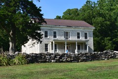
Listed on the National Register of Historic Places in 1985.
From the record
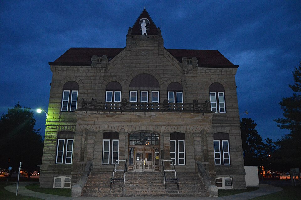
“Carrollton Courthouse Square Historic District is a historic district encompassing the courthouse square and surrounding commercial district in Carrollton, Greene County, Illinois. The district is centered on the Greene County Courthouse, a limestone Romanesque Revival building built in 1891-92.”
Wikipedia article Carrollton Courthouse Square Historic District, CC BY-SA 4.0.
One of 12 National Register listings published here for Greene County · listed in 1985 · category: District.
National Register reference number.85001667- the number the National Park Service assigned this property when it was listed, and the key its nomination file is catalogued under at the National Archives.
I put up at David Tefft's, who occupied a double frame one story building as a tavern on the east side of the Square, where I remained about a week, when, through the influence of Dr. Ero Chandler, I obtained boarding with Mr. Henry Robley, a farmer and blacksmith, over a mile east of the court house, and entirely out of town. From Carrollton to Edwardsville via Belleville, the country was beautiful, the land apparently rich, but thinly settled, with but few good houses or improved farms. From Edwardsville to Alton the road passed over a wooded and broken country, thin land, and but few. farms. From Alton to Carrollton after passing Piasa Creek, and getting on the prairie, the country was level, though sufficiently undulating for agricultural purposes. To Macoupin Creek and from there to Carrollton the road passes over a timbered and poor country, with but two or three small farms and one small brick house. Between Carrollton and Apple Creek the timber, undergrowth, and vegetation indicated deep, rich soil, equal to any that I had ever seen. At Carrollton I put up at a tavern kept by Mr. Harrison, south of the Square, in a small story and a half building. I went to a grocery store to purchase some cigars, when I found twenty or thirty men, (whom, I was told, were called Macoupinites,) drinking, carousing, cursing, swearing, singing obscene songs, and telling stories on each other. They were enjoying themselves to the fullest. One of them, who appeared to be sober and quiet, after asking me Avhere I was from and where I was going, said, 'you are too smart-looking to be in this crowd, and I advise you to leave before the boys notice you ; they are a wild set.' I thanked him for his advice and returned to the tavern.
The first church erected in Carrollton was used by the Baptist denomination. It stood a little out of town at that day, to the southeast. The pastor of this church for several years was one Aaron Smith, mentioned elsewhere, a Revolutionary pensioner. He was shot at Eutaw Springs, crawled into a clump of bushes, lay three days in a helpless condition, and was found by means of tiie flies that hovered around him. He resided a mile and a half southwest from Carrollton for a few years, and afterward moved north of Apple Creek. After some time, H
Regional context, not property-specific
evidence. The federal mineral resources record lists
1 working within 5 miles of Carrollton Courthouse Square Historic District: 1 past producer.
None of them still produces. What was taken out: Stone. Distance is straight-line from the
map coordinates, so a quarry counted here may appear on a neighbouring
settlement's page as well.
Regional context, not property-specific
evidence. The National Weather Service names
Carrollton, the town this property stands in, in 30 storm reports between 1995 and 2025: 18 thunderstorm wind, 10 hail, 1 flash flood, 1 tornado.
No death or injury is recorded in these reports. Each account below is quoted exactly as the forecast office
filed it, from the NOAA Storm Events Database, and each date
opens the federal record of that event.
Hail up to golfball size pounded Carrollton causing damage to automobiles and area roofs. Initial insurance estimates indicated at least $750,000 in damages.
A hay wagon was blown onto U.S. Highway 67 between White Hall and Carrolton. In Carrolton, a couch was blown onto U.S. Highway 67. In Greenfield, several power lines were blown down.
Thunderstorm winds blew down a few large trees, as well as numerous tree limbs and several power lines around town. Also, an unoccupied mobile home was blown off its foundation.
The tornado first touched down about 200 yards south of County Road 1150, about 80 yards west of U.S. Highway 67, damaging a four car garage. The roof of the garage was mostly removed from the structure with some small sections of the roof displaced a quarter of a mile to the north in an open field. The tornado travelled to the north over County Road 1150 and snapped some medium sized tree limbs. One power pole was snapped in this area. Also, a medium size storage unit was damaged with pieces of the storage unit displaced over 100 yards to the north. The tornado moved north nearly parallel to 6th Street where small and large tree limbs were snapped. Several witnesses including the local street department observed the tornado as it entered and moved through a residential area west of downtown Carrollton. One home near the southern part of the residential area sustained minor roof damage with shingles removed from the roof. The tornado crossed Illinois Route 108 just west of U.S. Highway 67 before lifting and dissipating. Mainly small to medium tree limbs were blown down as the tornado travelled north through this area. The path length of the tornado was approximately 1.44 miles and had a damage width which varied between 40 and 60 yards. The damage was rated EF0.
The damage across portions of Greene County was due to damaging downburst winds and localized microbursts embedded within the larger area of downburst winds. The damage area was generally confined from Carrollton to Greenfield and along Illinois Route 108 over the central and eastern parts of Greene County. One home in Greenfield was severely damaged as a large tree partially fell through the roof of the home. A few other large trees also fell on the west side of town. The western sections of the roof of a large machine shed west of Greenfield were also uplifted and tossed between 50 and 100 yards to the east. A few other homes in Greenfield sustained minor roof damage as some shingles were removed. A weather station located southeast of Greenfield measured a wind gust to 74 mph. Between Carrollton and Greenfield, several corn fields sustained damage as corn was partially bent with pockets of flattened corn. The area of wind damage extended approximately 14 miles along Illinois Route 108. The damage was 1.5 miles wide at the beginning of the damage path to 3.5 miles wide at the end.
Thunderstorm wind gusts downed some large tree limbs and power lines. The local power company reported that over 35 customers lost power in Carrollton.
No historic map-sheet match is published
for this property yet. That does not mean no map exists. This record needs
a coordinate-quality review before it can be joined to a sheet boundary.
Browse the county's mapped places while that work is
pending.
Listed places nearby
5 within 8 miles
Other National Register properties close
enough to walk or drive between, ordered by distance from this one. Both
positions come from the same geocoding pass that matched these properties
to their map sheets.
Listing record. National Park Service National Register of Historic Places, listed-properties dataset, current to 2026-05-22.
Map join. Address geocoded through the United States Census geocoder, then tested against the published boundary of every sheet in the USGS Historical Topographic Map Collection.
How this page is made. Listing fields come from federal records; map-sheet coverage is a labelled coordinate-to-boundary calculation, not a source-field claim.
Mines and quarries. USGS Mineral Resources Data System (MRDS) https://mrdata.usgs.gov/mrds/ A work of the United States government, no copyright under 17 U.S.C. 105.
Storms. NOAA National Centers for Environmental Information, Storm Events Database https://www.ncei.noaa.gov/stormevents/ A work of the United States government, no copyright under 17 U.S.C. 105. Narratives are quoted verbatim from the National Weather Service report and are not edited or summarised.
 Block