BlockBefore
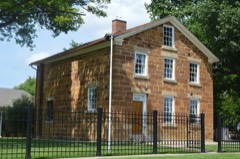
Photograph of Carthage Courthouse Square Historic District
Photograph by Nyttend, Public domain. Via Wikimedia Commons.

Carthage Courthouse Square Historic District

Listed on the National Register of Historic Places in 1986.

From the record

“The Carthage Courthouse Square Historic District is a historic district encompassing the courthouse square of Carthage, Hancock County, Illinois. The district includes 52 buildings, 42 of which are considered contributing to the district's historic character.”

Wikipedia article Carthage Courthouse Square Historic District (Carthage, Illinois), CC BY-SA 4.0.

One of 9 National Register listings published here for Hancock County · listed in 1986 · category: District.

Sources: the Wikipedia article · the case file at the National Archives · the National Register database, National Park Service · the Wikipedia article

The listing

The ground it stands on

27,987 words

The chapter on Carthage Township in History of Hancock County, Illinois, Together with an Outline History of the State, and a Digest of State Laws, published 1880 names Carthage. This is what it says, exactly as the scans read.

Hiram O. Ferris is a son of Stephen Gano Ferris, and was born in Steuben county, N. Y., in 1S2^. He was educated at Knox College, 111.; after completing his studies there in 1850, he crossed the plains to California, where he attained considerable prominence in politics. In the winter of 1851-'2 he was appointed by the Legislature of the State of California as one of the commissioners to organize the county of Siskij'ou. After serving on this commission until their work was finished, he was elected County Clerk of that county, in which capacity he served for two terms. In 1856 he returned to this county (Hancock). Having previously read and studied law, he made application to the Supreme Court of Illinois for admission to the " Bar," which, after undergoing an examination by that honorable court, was granted. Soon afterward, Mr. Ferris formed a partnership with Hooker & Edmunds, Att'ys, at Carthage, under the firm name of Ferris, Hooker & Edmunds. This firm was dissolved in 1863, and the business continued by Ferris & Hooker. In 1864 this firm was also dissolved, Mr. Ferris continuing the same until 1865. During this year he associated himself with F. M. Corby, and organized a banking institution, the firm being Ferris & Corby. They were also largely interested in real estate transactions.

Passage source: History of Hancock County, Illinois, Together with an Outline History of the State, and a Digest of State Laws, published 1880.

This banking institution formed the nucleus of what is now " The Hancock County National Bank, of Carthage," which was organized under certificate of authority dated May 18, 1865, by the Comptroller of Currency at Washington, D. C. The institution opened its doors for business as a national Ijank June 5, 1865. Mr. Ferris was at ouce elected President of this bank, continuing to hold the position to the present time. This bank is considered one of the most solid and substantial in the country, having passed through all the panics with credit unimpaired. Its officers have the unlimited confidence of the people in all transactions. The bank building is situated on the northwest corner of the Public Square in Carthage. It is a substantial brick structure and was built in 18Y1.

Passage source: History of Hancock County, Illinois, Together with an Outline History of the State, and a Digest of State Laws, published 1880.

Machine-read from a century-old scan, so expect the errors a machine makes: misspelled names, dropped words, stray characters.

Read the whole chapter on Carthage Township - 27,987 words on its settlement, mills, schools and churches.

Fires near this property

3 since 2003

Regional context, not property-specific evidence. The federal wildfire occurrence database lists 3 fires within 5 miles of Carthage Courthouse Square Historic District between 2003 and 2004, burning about 4 acres in total. None started naturally. None was recorded as arson. Distance is straight-line from the map coordinates, so a fire counted here may appear on a neighbouring settlement's page as well.

Reported cause Fires
Missing data/not specified/undetermined2
Equipment and vehicle use1

The most recent of them, most recent first, with the day each was reported and the service that recorded it.

DateCause SizeReported by Name on the report
6 April 2004Missing data/not specified/undetermined1.0 acresIllinois State Fire Marshal's Officenot named
30 October 2003Equipment and vehicle use1.0 acresIllinois State Fire Marshal's Officenot named
19 October 2003Missing data/not specified/undetermined2.5 acresIllinois State Fire Marshal's Officenot named

Every fire recorded in Hancock County

Mines and quarries near this property

4 within 5 miles

Regional context, not property-specific evidence. The federal mineral resources record lists 4 workings within 5 miles of Carthage Courthouse Square Historic District: 3 past producers, 1 plant. 1 still produces. What was taken out: Stone, Stone, Crushed/Broken, Sand and Gravel, Construction. Distance is straight-line from the map coordinates, so a quarry counted here may appear on a neighbouring settlement's page as well.

Where SiteCommodity StatusRecorded
Mo-Mac Quarry & MillStone, Crushed/BrokenPlant
Wright PitSand and Gravel, ConstructionPast Producer
Carthage City PitStonePast Producer
Hancock City PitStonePast Producer

Every working recorded in Hancock County

Storms near this property

51 since 1993

Regional context, not property-specific evidence. The National Weather Service names Carthage, the town this property stands in, in 51 storm reports between 1993 and 2025: 25 thunderstorm wind, 16 hail, 5 flood, 4 flash flood. No death or injury is recorded in these reports. Each account below is quoted exactly as the forecast office filed it, from the NOAA Storm Events Database, and each date opens the federal record of that event.

WhenEvent Place namedHarm What the report says
June 2011Thunderstorm WindCarthage$250,000Wind gust estimated to be 75 mph blew down some buildings between Carthage, IL and Bentley, IL around 145 am CDT June 27. This report was relayed by a COOP Observer.
July 2003Thunderstorm WindCarthage$60,000Numerous trees down
July 2000Thunderstorm WindCarthage$6,000Thunderstorm winds snapped several tree limbs, which resulted in spotty power outages throughout the community. One tree was uprooted, another blew down over a garage, and a third tree crushed a minivan.
July 2008Thunderstorm WindCarthage$5,000Wind gusts estimated to be 65 mph snapped the top of a tree off along Main Street in Carthage, IL around 800 pm July 27. The tree fell onto some power lines snapping one line and damaging a utility pole. Portions of some area corn fields just outside of town were also flattened.
August 2004Thunderstorm WindCarthage$5,000Sustained winds of 35 knots (40 mph) to over 43 knots (50 mph).
August 2004Thunderstorm WindCarthage$3,000Sustained winds of 35 knots (40 mph) to occasionally over 43 knots (50 mph).
July 2000Thunderstorm WindCarthage$250Law enforcement reported thunderstorm winds blew down a tree, which partially blocked a county road.
March 2025Thunderstorm WindCarthage-Large pine tree blown down. The time was estimated from radar data.
March 2024HailCarthage-Report received from social media, with radar estimated times.
June 2023Thunderstorm WindCarthage-Extensive tree damage throughout town. Strong winds lasted about 20 minutes, and began about 11 am CDT.
June 2019Thunderstorm WindCarthage-A trained spotter reported that a 15 foot Bradford Pear Tree was snapped off near the base. The time of the event was estimated using radar.
May 2019Flash FloodCarthage-Significant water over highways in the town of Carthage.
April 2014HailCarthage-A trained spotter reported dime sized hail.
June 2014Thunderstorm WindCarthage-A trained spotter measured 60 mph winds.
June 2013Thunderstorm WindCarthage-A trained spotter estimated 4 separate wind gusts of 50 to 60 mph.
June 2011Thunderstorm WindCarthage-A 65 mph wind gust was recorded about 1 mile east southeast of Carthage, IL at 144 am CDT June 27. Some power line flashes were also observed on the east side of Carthage.
June 2011Thunderstorm WindCarthage-Wind gusts estimated to be 70 mph blew down several trees and limbs in Carthage, IL around 145 am CDT June 27.
June 2011Flash FloodCarthage-Heavy rains caused some flash flooding in and east of Carthage, IL during the early morning of June 15. Several city streets were closed due to flooding. A portion of Highway 336/Highway 136 was closed due to water flowing over all four lanes near County Road 2500.
July 2010Thunderstorm WindCarthage-Wind gusts estimated to be 65 mph blew down a couple of trees in Carthage, IL at 140 pm CDT July 24.
December 2008Thunderstorm WindCarthage-Law enforcement reported power poles snapped off and half of a barn roof blown off about 2 miles southeast of Carthage. Winds were estimated at 75 mph.
June 2008Thunderstorm WindCarthage-Wind gusts estimated to be 70 mph blew down several trees in Carthage, IL at 1:50 pm June 15.
June 2008HailCarthage-Quarter to golf ball-sized hail fell in Carthage, IL at 1:50 pm June 15.
June 2008HailCarthage-Penny-sized hail fell in Carthage, IL at 1:53 pm June 15.
June 2008Thunderstorm WindCarthage-Wind gusts estimated to be 70 mph blew down numerous large trees across the city of Carthage, IL at 1:50 pm June 15. Some of the trees were uprooted. A power outage was also observed.
June 2008Thunderstorm WindCarthage-Wind gusts estimated to be 70 mph blew down several large healthy trees three to four feet in diameter across Carthage, IL at 1:55 pm June 15. A tall pine tree was snapped off about five feet above the ground.
June 2008Thunderstorm WindCarthage-Wind gusts estimated to be 70 mph blew down several trees and branches in Carthage, IL at 1:50 pm June 15. Power lines were also down.
June 2002Flash FloodCarthage-Flood water debris blocking many county roads.
May 2002Flash FloodCarthage-Highway 136 and route 96 were covered with water and impassable in spots.
August 2001HailCarthage-A trained spotter reported 0.75 inch hail.
August 2001FloodCarthage-Law enforcement reported street flooding in Carthage and over Route 96, south of Hamilton and Route 94, north of Carthage
August 2001Heavy RainCarthage-NWS Cooperative observer reported 24hr rainfall total of 6.30 inches
October 2001FloodCarthage-Law enforcement reported steet flooding.
October 2001FloodCarthage-Law enforcement reported 2.25 inches of rain in 3 hours, and numerous reports of urban ponding of water.
October 2001HailCarthage-Law enforcement reported 2.00 inch hail.
October 2001HailCarthage-Law enforcement reported 1.00 inch hail.
June 2000FloodCarthage-Water covered portions of Highway 136.
July 2000FloodCarthage-Torrential rains produced street flooding.
August 1993Thunderstorm WindCarthage-Wind gusts to 60 mph were reported at Carthage.
August 2018Thunderstorm WindCarthage-no account filed
March 2016HailCarthage-no account filed
April 2015HailCarthage-no account filed
April 2014HailCarthage-no account filed
May 2009HailCarthage-no account filed
June 2009HailCarthage-no account filed
May 2004HailCarthage-no account filed
June 2001Thunderstorm WindCarthage-no account filed
February 1999Thunderstorm WindCarthage-no account filed
May 1998HailCarthage-no account filed
June 1996Thunderstorm WindCarthage-no account filed
April 1996HailCarthage-no account filed
May 1995HailCarthage-no account filed

Every storm recorded in Hancock County

Map coverage status

No historic map-sheet match is published for this property yet. That does not mean no map exists. This record needs a coordinate-quality review before it can be joined to a sheet boundary. Browse the county's mapped places while that work is pending.

Listed places nearby

1 within 8 miles

Other National Register properties close enough to walk or drive between, ordered by distance from this one. Both positions come from the same geocoding pass that matched these properties to their map sheets.

Photograph PropertyDistance Listed
Carthage Jail0.3 miles1973

Sources for this property

National Archives recordThe nomination case file for reference 86001482 in Record Group 79.
Wikipedia articleCommunity-written account of this property, licensed CC BY-SA.
Hancock CountyAll 9 listed properties in this county.

Provenance

  • Listing record. National Park Service National Register of Historic Places, listed-properties dataset, current to 2026-05-22.
  • Map join. Address geocoded through the United States Census geocoder, then tested against the published boundary of every sheet in the USGS Historical Topographic Map Collection.
  • How this page is made. Listing fields come from federal records; map-sheet coverage is a labelled coordinate-to-boundary calculation, not a source-field claim.
  • Wildfire. Short, Karen C. 2022. Spatial wildfire occurrence data for the United States, 1992-2020 [FPA_FOD_20221014]. 6th Edition. Fort Collins, CO: Forest Service Research Data Archive. https://doi.org/10.2737/RDS-2013-0009.6 Collected with United States Government funding and usable without additional permissions or fees.
  • Mines and quarries. USGS Mineral Resources Data System (MRDS) https://mrdata.usgs.gov/mrds/ A work of the United States government, no copyright under 17 U.S.C. 105.
  • Storms. NOAA National Centers for Environmental Information, Storm Events Database https://www.ncei.noaa.gov/stormevents/ A work of the United States government, no copyright under 17 U.S.C. 105. Narratives are quoted verbatim from the National Weather Service report and are not edited or summarised.