
BlockBefore
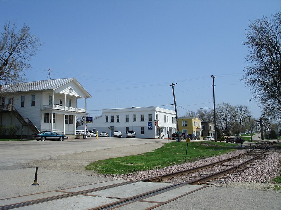
Photograph of Scales Mound Historic District
Photograph by IvoShandor, CC BY-SA 3.0. Via Wikimedia Commons.

Scales Mound Historic District

Listed on the National Register of Historic Places in 1990.

From the record

“The Scales Mound Historic District is a historic district in the small Illinois village of Scales Mound. The district encompasses the entire corporate limit of the village and has more than 200 properties within its boundaries.”

Wikipedia article Scales Mound Historic District, CC BY-SA 4.0.

One of 17 National Register listings published here for Jo Daviess County · listed in 1990 · category: District.

Sources: the Wikipedia article · the case file at the National Archives · the National Register database, National Park Service

The listing

  • Address. Roughly bounded by village corporate limits, Scales Mound, 61075
  • When was it listed? September 1990
  • Category. district
  • Township. Scales Mound township
  • National Register reference number. 90001199 - the number the National Park Service assigned this property when it was listed, and the key its nomination file is catalogued under at the National Archives.

The ground it stands on

10,168 words

The chapter on Scales Mound Township in The History of Jo Daviess County, Illinois, Containing a History of the County, Its Cities, Towns, Etc., a Biographical Directory of Its Citizens, War Record of Its Volunteers in the Late Rebellion ... History of the Northwest, History of Illinois ... Constitution of the United States, published 1878 names Scales Mound. This is what it says, exactly as the scans read.

In 1826, when the tide of immigration was drifting towards the lead mines of northwestern Illinois, a party of men, consisting of two brothers, named Watson, Joshua Streeter and three sons, John Wood, a Mr. Brigham, Mr. Blane and a few others, discovered the mines of the upper East Fork. They stopped there, built cabins and mined for four or five years. These men can not properly be considered as settlers of Scales Mound Township, as they left their families at other places, to which they would make frequent trips, and seemed to regard these mines as but a temporary location.

Passage source: The History of Jo Daviess County, Illinois, Containing a History of the County, Its Cities, Towns, Etc., a Biographical Directory of Its Citizens, War Record of Its Volunteers in the Late Rebellion ... History of the Northwest, History of Illinois ... Constitution of the United States, published 1878.

In 1830, Samuel H. Scales purchased the claim and cabin of John L. Sole, who had lived there nearly two years, and built a public house near the base of the mound, which is now known by his name. This tavern was on the historical " Sucker Trail " over which, afterwards, passed the Chicago & Galena stage line, and it was kept, in succession, by Scales, Moffett, Cowgill and Moppin. For many years after the village of Scales Mound was built, on the railroad, nearly a mile from the old tavern, the mound was generally distinguished by the name of " Maupin's Mound." It has now, however, reverted to its old title.

Passage source: The History of Jo Daviess County, Illinois, Containing a History of the County, Its Cities, Towns, Etc., a Biographical Directory of Its Citizens, War Record of Its Volunteers in the Late Rebellion ... History of the Northwest, History of Illinois ... Constitution of the United States, published 1878.

Machine-read from a century-old scan, so expect the errors a machine makes: misspelled names, dropped words, stray characters.

Read the whole chapter on Scales Mound Township - 10,168 words on its settlement, mills, schools and churches.

Fires near this property

4 since 2010

Regional context, not property-specific evidence. The federal wildfire occurrence database lists 4 fires within 5 miles of Scales Mound Historic District between 2010 and 2011, burning about 6 acres in total. None started naturally. None was recorded as arson. Distance is straight-line from the map coordinates, so a fire counted here may appear on a neighbouring settlement's page as well.

Reported cause Fires
Missing data/not specified/undetermined3
Equipment and vehicle use1

The most recent of them, most recent first, with the day each was reported and the service that recorded it.

DateCause SizeReported by Name on the report
19 April 2010Missing data/not specified/undeterminedunder an acreIllinois Division of Forestry ResourcesSCHAMPER
18 April 2010Missing data/not specified/undetermined1.0 acresIllinois Division of Forestry ResourcesJONES
9 March 2011Equipment and vehicle use4.0 acresIllinois Division of Forestry ResourcesGRENDA
19 March 2010Missing data/not specified/undetermined1.0 acresIllinois Division of Forestry ResourcesWATSON

Every fire recorded in Jo Daviess County

Mines and quarries near this property

10 of 49 shown

Regional context, not property-specific evidence. The federal mineral resources record lists 49 workings within 5 miles of Scales Mound Historic District: 31 past producers, 11 unknowns, 3 producers, 2 occurrences. 3 still produce. What was taken out: Lead, Zinc, Stone, Crushed/Broken, Lead, Zinc. Distance is straight-line from the map coordinates, so a quarry counted here may appear on a neighbouring settlement's page as well.

Where SiteCommodity StatusRecorded
Schullsburg MineZinc, Lead, Barium-Barite, IronProducerBarite, Galena, Marcasite, Pyrite, Sphalerite
Fields Upper Run MineZinc, LeadPast Producer
Magoon ProspectZinc, LeadOccurrence
Mulcahy MineZinc, LeadPast Producer1950, 1952
Vinegar Hill Blackstone MineZinc, LeadPast Producer1950
Annie Walton MineLead, ZincPast Producer1947
Magoon ProspectLead, ZincProspect
New Longhorn MineLead, ZincPast Producer1917, 1926
Rockford Mining and Milling Co. MineLead, ZincUnknown1905, 1915
Shullsburg MillLead, ZincPast Producer

Every working recorded in Jo Daviess County

Storms near this property

11 since 2007

Regional context, not property-specific evidence. The National Weather Service names Scales Mound, the town this property stands in, in 11 storm reports between 2007 and 2024: 7 hail, 3 thunderstorm wind, 1 tornado. No death or injury is recorded in these reports. Each account below is quoted exactly as the forecast office filed it, from the NOAA Storm Events Database, and each date opens the federal record of that event.

WhenEvent Place namedHarm What the report says
June 2010Thunderstorm WindScales Mound$25,000Wind gusts estimated to be 70 mph blew a roof off a house in Scales Mound, IL around 205 pm June 18.
May 2024Thunderstorm WindScales Mound-Trees and power lines blown down. Time estimated from radar data.
March 2016HailScales Mound-Dime size hail fell for 10 minutes.
June 2015Thunderstorm WindScales Mound-A member of the public reported a tree down on a house, and several small branches down in town.
July 2009HailScales Mound-Golf ball-sized hail fell in Scales Mound, IL around 535 pm July 24.
July 2009HailScales Mound-Golf ball-sized hail fell 2 miles east of Scales Mound, IL around 538 pm July 24.
May 2008HailScales Mound-Quarter-sized hail fell in Scales Mound, IL around 9:10 pm.
May 2008HailScales Mound-Nickel to quarter-sized hail fell in Scales Mound, IL between 9:30 and 9:45 pm.
June 2008HailScales Mound-Dime-sized hail fell in Scales Mound, IL at 1:14 pm June 28.
June 2007Tornado (EF0)Scales Mound-A tornado briefly touched down about 2 miles south of Scales Mound, IL. Some trees were damaged.
November 2022HailScales Mound-no account filed

Every storm recorded in Jo Daviess County

Map coverage status

No historic map-sheet match is published for this property yet. That does not mean no map exists. This record needs a coordinate-quality review before it can be joined to a sheet boundary. Browse the county's mapped places while that work is pending.

Sources for this property

National Archives recordThe nomination case file for reference 90001199 in Record Group 79.
Wikipedia articleCommunity-written account of this property, licensed CC BY-SA.
Jo Daviess CountyAll 17 listed properties in this county.

Provenance

  • Listing record. National Park Service National Register of Historic Places, listed-properties dataset, current to 2026-05-22.
  • Map join. Address geocoded through the United States Census geocoder, then tested against the published boundary of every sheet in the USGS Historical Topographic Map Collection.
  • How this page is made. Listing fields come from federal records; map-sheet coverage is a labelled coordinate-to-boundary calculation, not a source-field claim.
  • Wildfire. Short, Karen C. 2022. Spatial wildfire occurrence data for the United States, 1992-2020 [FPA_FOD_20221014]. 6th Edition. Fort Collins, CO: Forest Service Research Data Archive. https://doi.org/10.2737/RDS-2013-0009.6 Collected with United States Government funding and usable without additional permissions or fees.
  • Mines and quarries. USGS Mineral Resources Data System (MRDS) https://mrdata.usgs.gov/mrds/ A work of the United States government, no copyright under 17 U.S.C. 105.
  • Storms. NOAA National Centers for Environmental Information, Storm Events Database https://www.ncei.noaa.gov/stormevents/ A work of the United States government, no copyright under 17 U.S.C. 105. Narratives are quoted verbatim from the National Weather Service report and are not edited or summarised.