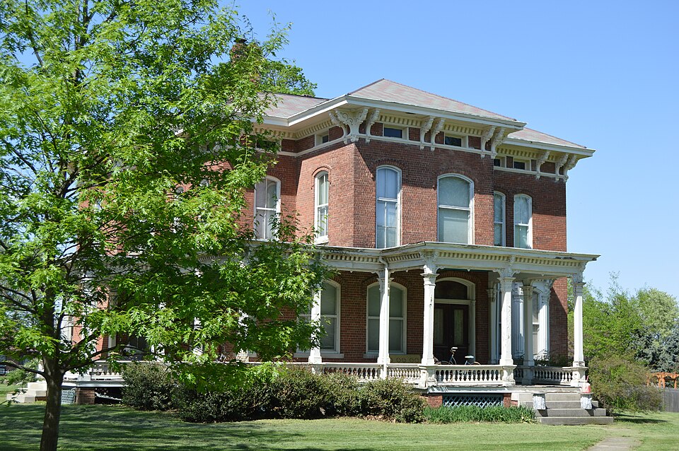
Listed on the National Register of Historic Places in 1991.
From the record
“The Price-Prather House is a historic house located at the intersection of Main and Elkhart Streets in Williamsville, Illinois. The house was built in 1868 for livestock breeder James R.”
Wikipedia article Price-Prather House, CC BY-SA 4.0.
One of 68 National Register listings published here for Sangamon County · listed in 1991 · category: Building.
National Register reference number.91000574- the number the National Park Service assigned this property when it was listed, and the key its nomination file is catalogued under at the National Archives.
Mrs. Rebecca Miller has a silver half-dollar given to her when a child by her mother, bearing date 1822, the year in which Mrs. Miller was born. In 1846, her husband desired to purchase a piece of land, and lacked one-half dollar of having the necessary amount to pay for it. The coveted half-dollar was given to him, and paid out on this purchase. In 1876, the identical half-dollar was given to him in change by a merchant in Williamsville, and by him returned to Mrs. Miller. Thus, after a lapse of thirty years, she received back the precious coin, paid out in Jackson City, Missouri.
A petition of the citizens was circulated, praying the post office department at Washington, to establish here a post office. Their petition was granted, and an office established in the spring of 1854, named Williamsville Post Office, with John George as postmastei*. Mr. George was subsequently succeeded by his son, Wesley George, who served until 1858, when Jacob Mc- Clure was appointed. From 1858 to the present time, the[.following named have had charge of the office: George Brown, Jacob McClure, Charles Elder, R. M. Lawrence, William Stewart, Sarah Stewart, and Jacob McClure, the second time, the incumbent.
Regional context, not property-specific
evidence. The
federal wildfire occurrence database
lists 15 fires within 5 miles of Price-Prather House
between 2002 and 2014, burning about 94 acres in total. None started naturally. None was recorded as arson.
Distance is straight-line from the map coordinates, so a fire counted
here may appear on a neighbouring settlement's page as well.
Reported cause
Fires
Missing data/not specified/undetermined
10
Debris and open burning
4
Recreation and ceremony
1
The most recent of
them, most recent first, with the day each was reported and the service
that recorded it.
Regional context, not property-specific
evidence. The National Weather Service names
Williamsville, the town this property stands in, in 24 storm reports between 1996 and 2022: 13 hail, 8 thunderstorm wind, 2 tornado, 1 flash flood.
The reports record 17 injuries. Each account below is quoted exactly as the forecast office
filed it, from the NOAA Storm Events Database, and each date
opens the federal record of that event.
The tornado touched down on the west side of Williamsville, just west of I-55, at 319 PM CST. It destroyed an antique mall, damaged the Casey's gas station building and collapsed the canopy over the gas pumps. One person was injured at the mall, while 2 motorcyclists were injured when they were thrown from their bikes. The tornado moved northeast through Williamsville and hit a church, throwing a 2-horse trailer onto the roof and collapsing the roof over half of the building. One person inside the church was injured. The tornado continued through the northern portion of town, causing damage to numerous trees and several homes. Two homes lost their roof and several others lost a portion of their roof. The tornado also caved in the southern end of a metal building, part of an agricultural business on the edge of town. A total of 12 additional people were injured by tornado debris in the town of Williamsville. The width of the tornado through town ranged from 100 to 150 yards. The maximum wind speed of 135 mph (EF2) in Williamsville was determined from the damage to the church. A total of 10 houses were destroyed and 35 houses damaged in Williamsville. A total of six businesses and non-residential properties were destroyed.||The tornado continued east-northeast and flattened cornfields, damaged farm outbuildings and machine sheds, and damaged homes, garages, and vehicles on Lester Rd. Two houses were completely destroyed, and four others had extensive damage, as the tornado widened to 600 yards at this point. A 19-month-old baby was injured as the family home was hit by the tornado. ||The maximum wind speed at this point was estimated at 140 mph (EF3). The tornado continued through fields, causing extensive crop damage, until crossing into Logan County around 326 PM CST. Path length through Sangamon County was 4.5 miles.
The roof of a pole barn was lifted off by strong winds. The building had no doors and was open to the south. Based on radar data, a microburst with winds of between 50 and 60 mph likely caused the damage.
Several trees were blown down or snapped off about 10 feet above the ground. Five homes sustained minor damage to their roof shingles and siding. A fence was blown down as well.
Rainfall amounts of 2.00 to 3.00, on top of waterlogged ground, were reported during the evening of June 28th. This resulted in the flooding of streets and viaducts in parts fo Springfield. Part of Illinois Route 124 from Williamsville to the Menard County line was also impassable.
Several trees were blown down eight miles west of Williamsville. One of the fallen trees landed on chimney and caused minor damage. No injuries were reported and no damage estimate was available.
No historic map-sheet match is published
for this property yet. That does not mean no map exists. This record needs
a coordinate-quality review before it can be joined to a sheet boundary.
Browse the county's mapped places while that work is
pending.
Listed places nearby
4 within 8 miles
Other National Register properties close
enough to walk or drive between, ordered by distance from this one. Both
positions come from the same geocoding pass that matched these properties
to their map sheets.
Listing record. National Park Service National Register of Historic Places, listed-properties dataset, current to 2026-05-22.
Map join. Address geocoded through the United States Census geocoder, then tested against the published boundary of every sheet in the USGS Historical Topographic Map Collection.
How this page is made. Listing fields come from federal records; map-sheet coverage is a labelled coordinate-to-boundary calculation, not a source-field claim.
Wildfire. Short, Karen C. 2022. Spatial wildfire occurrence data for the United States, 1992-2020 [FPA_FOD_20221014]. 6th Edition. Fort Collins, CO: Forest Service Research Data Archive. https://doi.org/10.2737/RDS-2013-0009.6 Collected with United States Government funding and usable without additional permissions or fees.
Storms. NOAA National Centers for Environmental Information, Storm Events Database https://www.ncei.noaa.gov/stormevents/ A work of the United States government, no copyright under 17 U.S.C. 105. Narratives are quoted verbatim from the National Weather Service report and are not edited or summarised.
 Block