BlockBefore
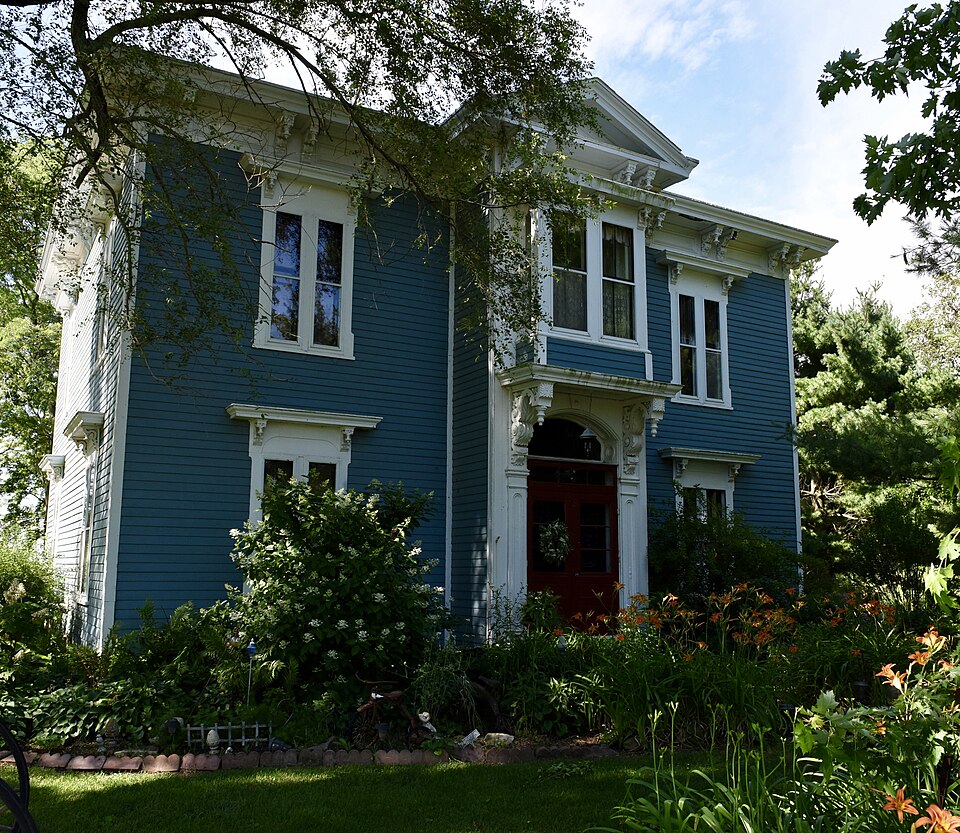
Photograph of Washington C. Wear House
Photograph by Jim Roberts, CC BY-SA 4.0. Via Wikimedia Commons.

Washington C. Wear House

Listed on the National Register of Historic Places in 1993.

From the record

“Wear House is a historic house located south of Princeville, Peoria County, Illinois. Wear, a farmer from Ohio, had the house built in 1870.”

Wikipedia article Washington C. Wear House, CC BY-SA 4.0.

One of 35 National Register listings published here for Peoria County · listed in 1993 · category: Building.

Sources: the Wikipedia article · the case file at the National Archives · the National Register database, National Park Service

The listing

  • What is counted as historic. The nomination lists 1 building as contributing to the listing.
  • Listed as. Wear, Washington C., House - the National Register files a house under its owner's surname.
  • Address. 1 mi. S and 0.4 mi. W of jct. of IL 90 and IL 91, Princeville, 61559
  • When was it listed? August 1993
  • Category. building
  • Township. Princeville township
  • National Register reference number. 93000838 - the number the National Park Service assigned this property when it was listed, and the key its nomination file is catalogued under at the National Archives.

The ground it stands on

1,078 words

The chapter on Princeville Township in The History of Peoria County, Illinois. Containing a History of the Northwest--history of Illinois--history of the County, Its Early Settlement, Growth, Development, Resources, Etc., Etc. .., published 1880 names Princeville. This is what it says, exactly as the scans read.

Is situated in the northern portion of the count}', on section 13 of Princeville township, on the Peoria and Rock Island railroad, twenty-two miles from Peoria, and is a nourishing town of about 900 inhabitants. It was laid out and named by Wm. C. Stevens, on the 20th day of June, 1837, in the midst of a rich and fertile prairie.

Passage source: The History of Peoria County, Illinois. Containing a History of the Northwest--history of Illinois--history of the County, Its Early Settlement, Growth, Development, Resources, Etc., Etc. .., published 1880.

The first store in Princeville was kept by Elisha Morrow, on block No. 9, (owned by Thos. Morrow,) in a log building, where he remained about two years. Afterwards, Mr. Wm. C. Stevens put in a small stock of goods - as he says - to hold the village together. After the closing out of Morrow, Hitchcock & Rowley embarked in business in the same building. They were afterwards succeeded by J. W. Gue, in 1851, where he remained a short time and then built the brick store now occupied by F. B. Blanchard, it being the first brick store in the town.

Passage source: The History of Peoria County, Illinois. Containing a History of the Northwest--history of Illinois--history of the County, Its Early Settlement, Growth, Development, Resources, Etc., Etc. .., published 1880.

Machine-read from a century-old scan, so expect the errors a machine makes: misspelled names, dropped words, stray characters.

Read the whole chapter on Princeville Township - 1,078 words on its settlement, mills, schools and churches.

Mines and quarries near this property

6 within 5 miles

Regional context, not property-specific evidence. The federal mineral resources record lists 6 workings within 5 miles of Washington C. Wear House: 3 past producers, 2 occurrences, 1 producer. 1 still produces. What was taken out: Stone, Crushed/Broken, Sand and Gravel, Construction, Clay. Distance is straight-line from the map coordinates, so a quarry counted here may appear on a neighbouring settlement's page as well.

Where SiteCommodity StatusRecorded
Prince Run Creek Shale ExposureClayPast Producer
Chipman PitSand and Gravel, ConstructionPast Producer
Stoekers PitSand and Gravel, ConstructionPast Producer
Limestone ProspectStone, Crushed/BrokenOccurrence
Long Rock QuarryStone, Crushed/BrokenProducer

Every working recorded in Peoria County

Storms near this property

32 since 1995

Regional context, not property-specific evidence. The National Weather Service names Princeville, the town this property stands in, in 32 storm reports between 1995 and 2024: 16 thunderstorm wind, 13 hail, 2 tornado, 1 lightning. No death or injury is recorded in these reports. Each account below is quoted exactly as the forecast office filed it, from the NOAA Storm Events Database, and each date opens the federal record of that event.

WhenEvent Place namedHarm What the report says
August 2022LightningPrinceville$50,000A house was struck by lightning near the intersection of Highway 91 and Streitmatter Road causing a fire that damaged the attic.
July 2020Thunderstorm WindPrinceville$40,000Several trees were blown down.
August 2020Thunderstorm WindPrinceville$30,000The roof of a greenhouse was damaged just west of Princeville.
August 2008Thunderstorm WindPrinceville$25,000Two outbuildings were destroyed. A garage was damaged, with debris from the structure blocking a road. One horse was injured.
September 2014Thunderstorm WindPrinceville$15,000A few trees were uprooted and numerous tree branches were blown down. The roof of a barn was lifted up on the back wall and flashing/gutter damage occurred to the roof of a house.
May 2012Thunderstorm WindPrinceville$15,000Numerous tree limbs were blown down in Princeville.
June 2009Thunderstorm WindPrinceville$3,000A 16-inch diameter tree was blown down.
June 2008Thunderstorm WindPrinceville$1,000An 18-inch diameter tree was snapped.
June 2024Thunderstorm WindPrinceville-A tree was blown down across a road.
July 2024Thunderstorm WindPrinceville-Several tree branches were broken.
April 2023Thunderstorm WindPrinceville-A 59 mph gust was measured by the emergency manager two miles south of Princeville.
March 2017Thunderstorm WindPrinceville-A 12-inch diameter tree limb was blown down.
July 2017Tornado (EF0)Princeville-A tornado briefly touched down in a field 3.1 miles SSE of Princeville at 5:45 PM CDT. The tornado tracked ENE and quickly dissipated 2.2 miles NW of Dunlap at 5:53 PM CDT. No damage was reported.
August 2007Thunderstorm WindPrinceville-Numerous 3 inch diameter tree limbs were blown down.|
April 2006HailPrinceville-Hail ranging from nickel size to 2 inches in diameter from the vicinity of Princeville, to Dunlap, to Rome, to Chillicothe.
August 1997Thunderstorm WindPrinceville-Thunderstorm winds blew down a tree 2 miles west of Princeville. No injuries or damage were reported.
April 1997Thunderstorm WindPrinceville-Thunderstorm winds took the roof off of a trailer and blew down several trees 2 miles north of Princeville. No injuries or damage estimate were available.
May 1995Tornado (F1)Princeville-A tornado touched down 1 W of Princeville and traveled to the east northeast. Two homes were destroyed and two homes had major damage. Several outbuildings were either damaged or destroyed, as well as, numerous trees. Also, a country club in Edelstein sustained major roof damage. Numerous power poles were blown down as well. No injuries were reported and no damage estimate was available.
June 2024Thunderstorm WindPrinceville-no account filed
June 2024HailPrinceville-no account filed
February 2017HailPrinceville-no account filed
April 2015HailPrinceville-no account filed
November 2013HailPrinceville-no account filed
April 2012HailPrinceville-no account filed
May 2012HailPrinceville-no account filed
April 2011HailPrinceville-no account filed
June 2010HailPrinceville-no account filed
June 2009HailPrinceville-no account filed
May 2008HailPrinceville-no account filed
May 2005Thunderstorm WindPrinceville-no account filed
May 2004HailPrinceville-no account filed

Every storm recorded in Peoria County

Map coverage status

No historic map-sheet match is published for this property yet. That does not mean no map exists. This record needs a coordinate-quality review before it can be joined to a sheet boundary. Browse the county's mapped places while that work is pending.

Listed places nearby

1 within 8 miles

Other National Register properties close enough to walk or drive between, ordered by distance from this one. Both positions come from the same geocoding pass that matched these properties to their map sheets.

Photograph PropertyDistance Listed
Jubilee College6.1 miles1972

Sources for this property

National Archives recordThe nomination case file for reference 93000838 in Record Group 79.
Wikipedia articleCommunity-written account of this property, licensed CC BY-SA.
Peoria CountyAll 35 listed properties in this county.

Provenance

  • Listing record. National Park Service National Register of Historic Places, listed-properties dataset, current to 2026-05-22.
  • Map join. Address geocoded through the United States Census geocoder, then tested against the published boundary of every sheet in the USGS Historical Topographic Map Collection.
  • How this page is made. Listing fields come from federal records; map-sheet coverage is a labelled coordinate-to-boundary calculation, not a source-field claim.
  • Mines and quarries. USGS Mineral Resources Data System (MRDS) https://mrdata.usgs.gov/mrds/ A work of the United States government, no copyright under 17 U.S.C. 105.
  • Storms. NOAA National Centers for Environmental Information, Storm Events Database https://www.ncei.noaa.gov/stormevents/ A work of the United States government, no copyright under 17 U.S.C. 105. Narratives are quoted verbatim from the National Weather Service report and are not edited or summarised.