
BlockBefore
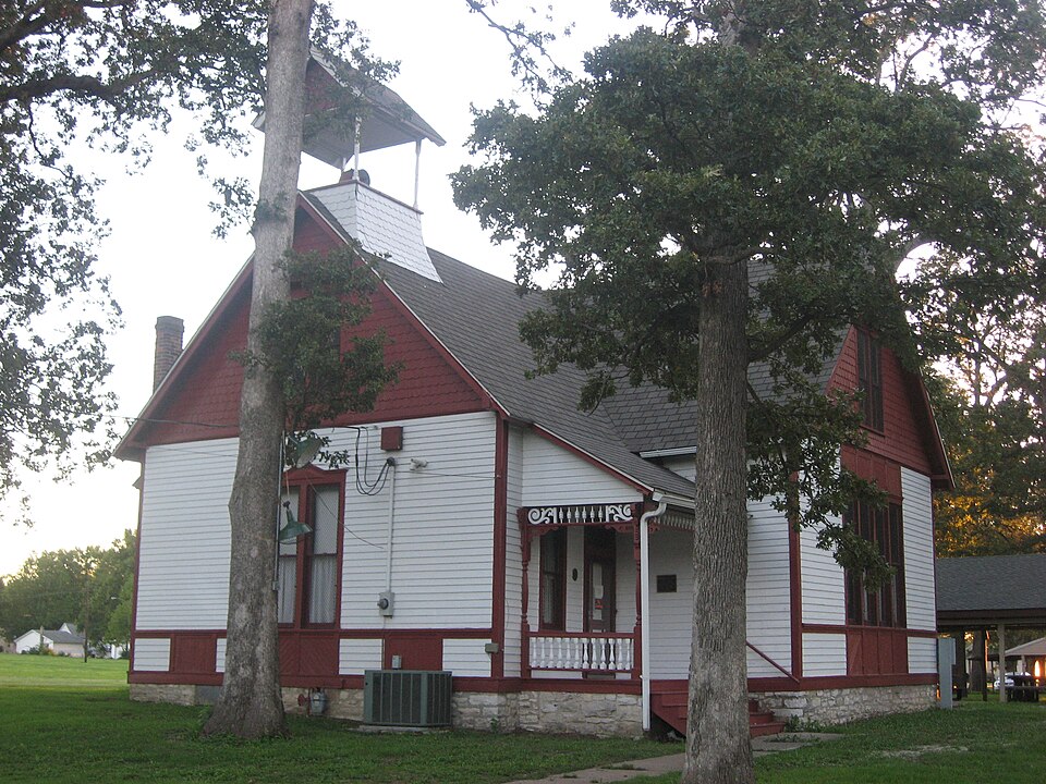
Photograph of Marissa Academy
Photograph by Nyttend, Public domain. Via Wikimedia Commons.

Marissa Academy

Listed on the National Register of Historic Places in 1994.

From the record

“The Marissa Academy is a historic school building located at 610 S. The building was built in 1891 for the Marissa Academy, a college preparatory academy which had graduated its first class two years prior.”

Wikipedia article Marissa Academy, CC BY-SA 4.0.

One of 27 National Register listings published here for St. Clair County · listed in 1994 · category: Building.

Sources: the Wikipedia article · the case file at the National Archives · the National Register database, National Park Service

The listing

  • What is counted as historic. The nomination lists 1 building as contributing to the listing.
  • Address. 610 S. Main St., Marissa, 62257
  • When was it listed? October 1994
  • Category. building
  • Township. Marissa township
  • National Register reference number. 94001267 - the number the National Park Service assigned this property when it was listed, and the key its nomination file is catalogued under at the National Archives.

The ground it stands on

763 words

The chapter on Marissa Township in Centennial, McKendree College, with St. Clair County History, published 1928 names Marissa. This is what it says, exactly as the scans read.

The original town of Marissa was laid out by James Stewart in December, 1867. It soon became a village with a few dwellings, a general store, a blacksmith shop, and a mill which could turn out a hundred barrels of flour a day. In 1870 when the railroad, known as the "Cairo Short Line" ran through, it left the village a little to one side. Of course since the railroad would not come to the town, the town had to go to the railroad. Accordingly a site was chosen for a station and a new town was laid out by M. E. and J. C. Hamilton.

Passage source: Centennial, McKendree College, with St. Clair County History, published 1928.

The old and the new towns were not too far apart to grow together, and now they are connected by a continuous street and together have a population probably about two thousand. The name was selected by James Wilson, the first postmaster, who showed his love for classic lore by choosing a name preserved only in Latin records. It was the name of a city destroyed, and afterwards rebuilt, by Gabinius, and our St. Clair County city is now believed to be the only place in the world by that name. One of the founders, John Hamilton, came to this county from South Carolina in 1834. M. E. Hamilton erected the first business house; the mill was built and operated for many years by A. J. Meek; and the Wyllie brothers ran a store. The town was not incorporated until 1882 but it has easily outgrown some of its older neighbors. It has the usual type of business houses, stores, banks, garages, and electric light plant, and the coal mining interests are a strong rival to the agricultural in that community. The public school employs twelve teachers, and the excellent Township high school has eight. There are churches of sev- eral denominations. The leading one is the United Presbyterian. There are also Methodists, Baptists, and Evangehcals. Marissa had the distinction of being a prohibition town long before the days of the eighteenth amendment.

Passage source: Centennial, McKendree College, with St. Clair County History, published 1928.

Machine-read from a century-old scan, so expect the errors a machine makes: misspelled names, dropped words, stray characters.

Read the whole chapter on Marissa Township - 763 words on its settlement, mills, schools and churches.

Storms near this property

43 since 1996

Regional context, not property-specific evidence. The National Weather Service names Marissa, the town this property stands in, in 43 storm reports between 1996 and 2026: 24 thunderstorm wind, 17 hail, 1 tornado, 1 flash flood. No death or injury is recorded in these reports. Each account below is quoted exactly as the forecast office filed it, from the NOAA Storm Events Database, and each date opens the federal record of that event.

WhenEvent Place namedHarm What the report says
May 1996Thunderstorm WindMarissa$5,000no account filed
March 2026Thunderstorm WindOld Marissa-A report from social media showed a destroyed carport caused by thunderstorm winds.
September 2023Thunderstorm WindOld Marissa-Broadcast media reported that trees and power lines were knocked down in and around Marissa, with the most damage occurring on the southeast side of town. No information was given on the details of the trees.
May 2013Thunderstorm WindOld Marissa-Thunderstorm winds blew down several medium to large trees as well as several power lines around town. A few shingles were blown off of a couple of homes.
April 2012HailMarissa-Hail was covering the ground on the southside of Marissa.
July 2012HailMarissa-Large hail fell on the south side of Marissa. The large hail cracked a windshield on one vehicle.
June 2011Thunderstorm WindOld Marissa-Thunderstorm winds blew part of the metal roof off of a shed. Also, several large trees, numerous tree limbs and power lines were blown down.
April 2011Thunderstorm WindOld Marissa-Thunderstorm winds blew down a large tree onto power lines, knocking the power lines down.
June 2011Thunderstorm WindOld Marissa-Thunderstorm winds blew down several large trees and power lines.
June 2011Thunderstorm WindOld Marissa-Thunderstorm winds blew down a tree onto a house causing moderate damage.
August 2011Thunderstorm WindOld Marissa-Thunderstorm winds blew down several tree limbs as well as one tree. The tree pulled down some power lines in downtown Marissa.
April 2011Thunderstorm WindOld Marissa-Thunderstorm winds blew down a few trees and power lines.
October 2010Thunderstorm WindOld Marissa-Thunderstorm winds blew over several large trees and knocked down numerous tree limbs.
August 2010Thunderstorm WindMarissa-Thunderstorm winds blew down a 90 foot tree on the north side of Marissa. Also, numerous large tree limbs were blown down around town.
June 2009Flash FloodMarissa-Up to three inches of rain fell in a short amount of time causing flash flooding. Numerous roads had water over them including Illinois Route 4 at School View Drive and on Lickenbrock School Road a mile north of Darmstadt Road.
February 2006Thunderstorm WindMarissa-Storm spotters reported power lines down at several locations in town.
May 2006HailMarissa-Hail was covering the ground.
July 2004Thunderstorm WindMarissa-The local newspaper reported several large tree limbs and moderate size trees down from thunderstorm winds.
August 2004Thunderstorm WindMarissa-Local law enforcement reported trees, power lines down and a machine shed damaged.
April 2002HailMarissa-Storm spotters reported 3/4 inch hail.
April 1998Tornado (F0)Marissa-The Marissa Fire Chief reported a small tornado near the fire station. Damage consisted of a few downed trees, the bleachers at a baseball field were destroyed, and a trash dumpster was blown into the side of a building breaking some bricks.
April 1998HailMarissa-Golfball size hail fell for several minutes in Marissa.
June 1997Thunderstorm WindMarissa-Wind gusts downed trees and power lines.
June 2011HailOld Marissa-no account filed
May 2010HailOld Marissa-no account filed
April 2009HailOld Marissa-no account filed
March 2009HailMarissa-no account filed
January 2008HailMarissa-no account filed
June 2008HailMarissa-no account filed
March 2006HailMarissa-no account filed
May 2006Thunderstorm WindMarissa-no account filed
May 2006HailMarissa-no account filed
June 2005Thunderstorm WindMarissa-no account filed
July 2004Thunderstorm WindMarissa-no account filed
July 2004HailMarissa-no account filed
July 2000Thunderstorm WindMarissa-no account filed
June 1998Thunderstorm WindMarissa-no account filed
May 1996HailMarissa-no account filed
July 1996Thunderstorm WindMarissa-no account filed
August 1996Thunderstorm WindMarissa-no account filed
March 1996HailMarissa-no account filed

Every storm recorded in St. Clair County

Map coverage status

No historic map-sheet match is published for this property yet. That does not mean no map exists. This record needs a coordinate-quality review before it can be joined to a sheet boundary. Browse the county's mapped places while that work is pending.

Sources for this property

National Archives recordThe nomination case file for reference 94001267 in Record Group 79.
Wikipedia articleCommunity-written account of this property, licensed CC BY-SA.
St. Clair CountyAll 27 listed properties in this county.

Provenance

  • Listing record. National Park Service National Register of Historic Places, listed-properties dataset, current to 2026-05-22.
  • Map join. Address geocoded through the United States Census geocoder, then tested against the published boundary of every sheet in the USGS Historical Topographic Map Collection.
  • How this page is made. Listing fields come from federal records; map-sheet coverage is a labelled coordinate-to-boundary calculation, not a source-field claim.
  • Storms. NOAA National Centers for Environmental Information, Storm Events Database https://www.ncei.noaa.gov/stormevents/ A work of the United States government, no copyright under 17 U.S.C. 105. Narratives are quoted verbatim from the National Weather Service report and are not edited or summarised.