
BlockBefore
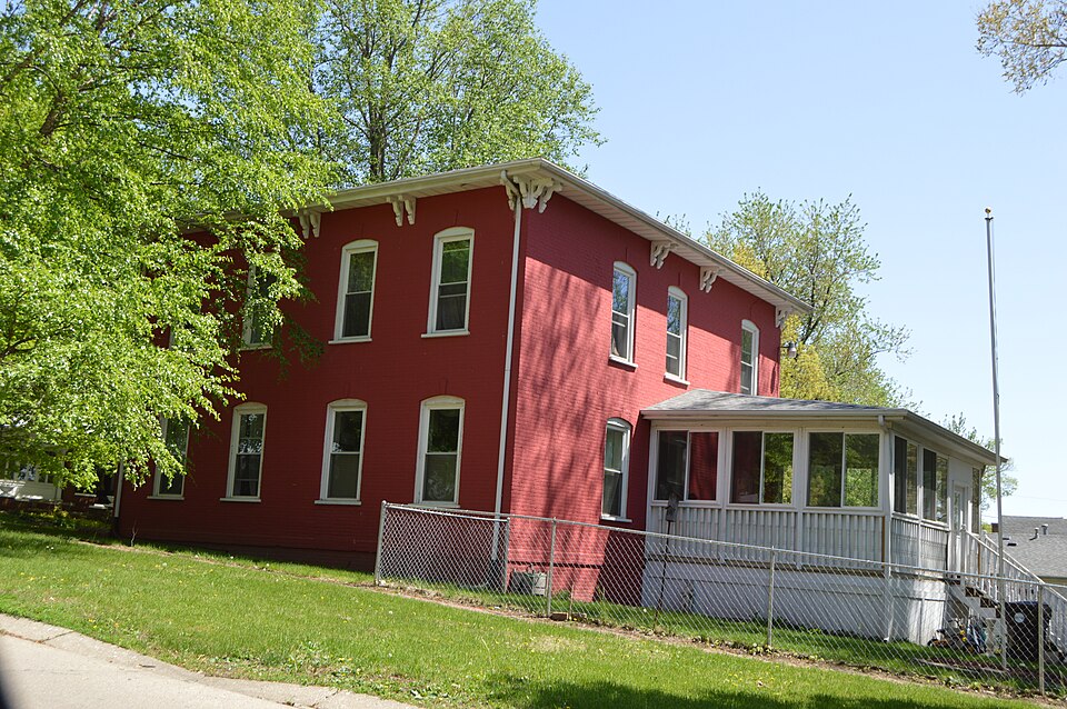
Photograph of Theodore H. O. Mattfeldt House
Photograph by Nyttend, Public domain. Via Wikimedia Commons.

Theodore H. O. Mattfeldt House

Listed on the National Register of Historic Places in 1996.

From the record

“Mattfeldt House is a historic house located at 202 S. The house was constructed circa 1860 for Theodore H.”

Wikipedia article Theodore H. O. Mattfeldt House, CC BY-SA 4.0.

One of 12 National Register listings published here for Logan County · listed in 1996 · category: Building.

Sources: the Wikipedia article · the case file at the National Archives · the National Register database, National Park Service

The listing

  • What is counted as historic. The nomination lists 1 building as contributing to the listing.
  • Listed as. Mattfeldt, Theodore H. O., House - the National Register files a house under its owner's surname.
  • Address. 202 S. Marion St., Mt. Pulaski, 62548
  • When was it listed? August 1996
  • Category. building
  • Township. Mount Pulaski township
  • National Register reference number. 96000853 - the number the National Park Service assigned this property when it was listed, and the key its nomination file is catalogued under at the National Archives.

The ground it stands on

12,245 words

The chapter on Mount Pulaski Township in History of Logan County, Illinois : Its Past and Present .., published 1878 names Mt. Pulaski. This is what it says, exactly as the scans read.

BEIDLEB SAMUEL LINN, postmaster and druggist, Mt. Pulaski; was bora in Lancaster Co. Pa. June 23, 1837; lived in Trenton, N. J. in 1852-3; went from there to Ross Co. Ohio; remained during the years 1854-5-6; came to this county in 1857, and to this village the following fall; was appointed postmaster by James Buchanan immediately after he arrived here, and has held the office ever since, with the exception of about a year during Andrew Johnson's administration; was director of the G. C. & S. R.R. from its organization in 1870 till 1876; married Miss Piudence Ann Capps, Feb. 8, i860; she was born in Mt. Pulaski, Dec 18, 1841; have had eight children, viz : Helen, bom Nov. 3, i860, deceased; Monitor Clarence, bom Jan.- 12, 1862; Frank X. bom Feb. 16, 1864; John^ Linndemuth, bom Dec. 27, 1865; Snow Flake, bom Dea 13, 1867; Imogene A. bom Oct. 5, 1872; Bell Capps, bom Feb. 7, 1874; George Hoke, born Dec. ao, 1876; owns twenty lots and fourteen houses in Mt Pulaski, valued at $18,000; also, section of land in Kansas, valued at $10 per acre; persoi^al^prpp^rtx $10,000; black rep; Universalist .

Passage source: History of Logan County, Illinois : Its Past and Present .., published 1878.

CASS FRANK J>. M.D. physician and surgeon, Mt. Pulaski; rep; MedL-Epis; bora, in 1832, in what was dien Sangamon Co. now Logan; graduated from Rush Medical College, Chicago, in 1863, and from the Miami Medical College, Cincinnati, Ohio, in 1876; married Sarah 6. Landis, of this county, in 1858; has one iiad five children: John, Mary S. (married ' Wniiam Burr), Maggie A. (married Thomas Anderson), Lucy C. (married Thomas Clark), and Dahlia, deceased

Passage source: History of Logan County, Illinois : Its Past and Present .., published 1878.

Machine-read from a century-old scan, so expect the errors a machine makes: misspelled names, dropped words, stray characters.

Read the whole chapter on Mount Pulaski Township - 12,245 words on its settlement, mills, schools and churches.

Fires near this property

2 since 2009

Regional context, not property-specific evidence. The federal wildfire occurrence database lists 2 fires within 5 miles of Theodore H. O. Mattfeldt House between 2009 and 2010, burning about 8 acres in total. None started naturally. None was recorded as arson. Distance is straight-line from the map coordinates, so a fire counted here may appear on a neighbouring settlement's page as well.

Reported cause Fires
Debris and open burning1
Missing data/not specified/undetermined1

The most recent of them, most recent first, with the day each was reported and the service that recorded it.

DateCause SizeReported by Name on the report
6 March 2009Missing data/not specified/undetermined7.0 acresIllinois Division of Forestry ResourcesFRICKE
17 November 2010Debris and open burning1.0 acresIllinois Division of Forestry Resources10368

Every fire recorded in Logan County

Mines and quarries near this property

2 within 5 miles

Regional context, not property-specific evidence. The federal mineral resources record lists 2 workings within 5 miles of Theodore H. O. Mattfeldt House: 2 producers. All of them still produce. What was taken out: Sand and Gravel, Construction. Distance is straight-line from the map coordinates, so a quarry counted here may appear on a neighbouring settlement's page as well.

Where SiteCommodity StatusRecorded
Allsopp Sand & Gravel PitSand and Gravel, ConstructionProducer
Fulk PitSand and Gravel, ConstructionProducer

Every working recorded in Logan County

Map coverage status

No historic map-sheet match is published for this property yet. That does not mean no map exists. This record needs a coordinate-quality review before it can be joined to a sheet boundary. Browse the county's mapped places while that work is pending.

Listed places nearby

2 within 8 miles

Other National Register properties close enough to walk or drive between, ordered by distance from this one. Both positions come from the same geocoding pass that matched these properties to their map sheets.

Photograph PropertyDistance Listed
Mount Pulaski Courthouseunder 500 feet1978
Robert Buckles Barn1.7 miles1983

Sources for this property

National Archives recordThe nomination case file for reference 96000853 in Record Group 79.
Wikipedia articleCommunity-written account of this property, licensed CC BY-SA.
Logan CountyAll 12 listed properties in this county.

Provenance

  • Listing record. National Park Service National Register of Historic Places, listed-properties dataset, current to 2026-05-22.
  • Map join. Address geocoded through the United States Census geocoder, then tested against the published boundary of every sheet in the USGS Historical Topographic Map Collection.
  • How this page is made. Listing fields come from federal records; map-sheet coverage is a labelled coordinate-to-boundary calculation, not a source-field claim.
  • Wildfire. Short, Karen C. 2022. Spatial wildfire occurrence data for the United States, 1992-2020 [FPA_FOD_20221014]. 6th Edition. Fort Collins, CO: Forest Service Research Data Archive. https://doi.org/10.2737/RDS-2013-0009.6 Collected with United States Government funding and usable without additional permissions or fees.
  • Mines and quarries. USGS Mineral Resources Data System (MRDS) https://mrdata.usgs.gov/mrds/ A work of the United States government, no copyright under 17 U.S.C. 105.