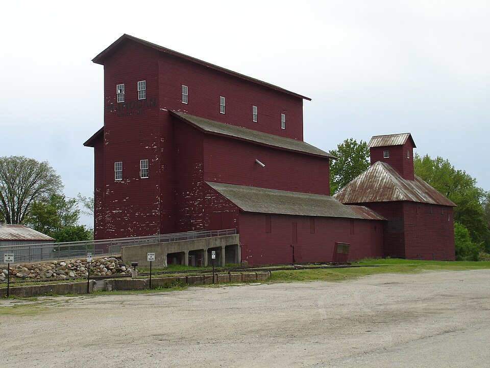
Built in 1861. Listed on the National Register of Historic Places in 1997.
From the record
“Armour's Warehouse, also known as the Seneca Grain Elevator or the Hogan's North Elevator, is a historic grain elevator located in the village of Seneca, Illinois, United States. The elevator and two surrounding outbuildings were listed on the U.S.”
Wikipedia article Armour's Warehouse, CC BY-SA 4.0.
One of 29 National Register listings published here for LaSalle County · listed in 1997 · category: Structure · built in 1861.
National Register reference number.97001333- the number the National Park Service assigned this property when it was listed, and the key its nomination file is catalogued under at the National Archives.
Wm. Richey was born in Pennsylvania, emigrated to Huron County, Ohio, where he heard the cannonading at the time of Perry's victory on Lake Erie. Lest his first wife and marricd Dolly Wilson, a Kentucky woman, near Indianapolis, in 1828, Moved to Wisconsin, and engaged in lead mining. Tn October, 1829, came to La Salle County, and made 'a claim on 8. 17, T. 33, R. 4, where William Moore now lives. He was accompanied by his son William W., the only child of his first wife that came West. 'The son stayed on the claim while the father went to the Blne Mounds for the family. They came by the way of Dixon, in a 'prairie schooner,"' with @ span of horses, and an ox and cow yoked together; arrived on the claim in January, 1830, The Only neighbor was James Galloway. In February, 1820, Mrs. Galloway died. Mr. Richey and son cut down a black walnut tree the Indians had girdled, and split ont some puncheon boards and made a coffin, in which Mrs. Galloway was buried. In the 'spring of 1830 Mr. Richey sold his claim to Abraham Trumbo. They then made a claim near Galloway's, but sold to Galloway soon after and made a claim on the S. E.3S. 18, I. 33, R. 6, and in the winter of 1831 built a cabin in the ravine near the Dr. Ward place, the first cabin built in Marseilles, and where James Richey was born, the first birth in what is now Marseilles, William W. sowed a email patch of wheat where the sod had been killed by Indian cultivation ; he got some what, but, what was more valuable, unwittingly got # pre-emption, and as he and his father were on the same quarter section, they were each entitled to a float on eighty acreselsewhere. They sold their floats to John Green, for which he entered their quarter section; they thus secured their quarter section without money and without price. After the massacre at Indian Creek, in 1832, William W. went to Seneca to notify Abel Sprague, who had a claim there, and then moved the family to Ottawa, The father was a teamster for the army, and the son enlisted as a soldier, They were discharged on the banks of the Wisconsin river. In the fall they helped Ephraim Sprague, Charles Brown, and Richard Hogaboom build a dam and dig a race fora eaw-mill at Marseilles. William Richey died about 1842; his wife died in 1839. William W narried Widow Green, and lives in the town of Brookfield.
Abdolonymus Stebbins, brother of Abner, and wile, Julia Webber, came from New York in 183, and settled on 8. 8, T. 33, R. 5. Had ten children. Bromback says he was not 20 good a worker but a better talker than Abner; that he was a staunch Whig, in favor of internal improvements, of developing manufactures, arts and sciences, and delighted in talking on these subjects by the hour; that there have been bigger fools in the United States Senate than Abdolonymus; that the good seed sown by him is still bearing frait; but that his Democratic held himand his political heresies in utter contempt, His children were; Henry, married Mary Ann Pope, his second wife was Miss Bignal, is now in Iowa; Lonana, married Jacob Reser, of Pontise ; Lorinda, married Volney Wood, both are deceased; Mary, died single; Louisa, married Gale Waterman, of Seneca; Emery, married Laura Lammy, of Iowa; Edgar, is in Missouri; Austin, mar. tied Miss Wiley, now in Florida. There are two
Regional context, not property-specific
evidence. The
federal wildfire occurrence database
lists 17 fires within 5 miles of Armour's Warehouse
between 2018 and 2020, burning about 29 acres in total. None started naturally. None was recorded as arson.
Distance is straight-line from the map coordinates, so a fire counted
here may appear on a neighbouring settlement's page as well.
Reported cause
Fires
Debris and open burning
11
Missing data/not specified/undetermined
3
Smoking
2
Fireworks
1
The most recent of
them, most recent first, with the day each was reported and the service
that recorded it.
Regional context, not property-specific
evidence. The federal mineral resources record lists
7 workings within 5 miles of Armour's Warehouse: 5 past producers, 2 producers.
2 still produce. What was taken out: Sand and Gravel, Construction, Stone, Crushed/Broken. Distance is straight-line from the
map coordinates, so a quarry counted here may appear on a neighbouring
settlement's page as well.
Regional context, not property-specific
evidence. The National Weather Service names
Seneca, the town this property stands in, in 12 storm reports between 1999 and 2022: 5 thunderstorm wind, 4 flood, 2 flash flood, 1 hail.
No death or injury is recorded in these reports. Each account below is quoted exactly as the forecast office
filed it, from the NOAA Storm Events Database, and each date
opens the federal record of that event.
The Illinois River reached a record crest of 33.79 feet at LaSalle on the 16th. Major flooding occurred along the river in LaSalle County. In Marseilles, flood waters inundated Illini State Park and nearby areas. Flood waters inundated the Peru power plant. Brunner and Water Streets were closed due to flooding. Navigation on the river was halted as most lock facilities were submerged. The Interstate 39 bridge was the only one open as State Highways 251, 351, and 178 were closed. Homes and businesses in Utica were flooded. In Ottawa, 89 residents of a nursing home were evacuated. Dee Bennett Road between Ottawa and Utica was closed. Central Elementary School in Ottawa was surrounded by water and the auditorium was flooded with 8 inches of water.
A slow moving thunderstorm produced torrential rain and flash flooding across portions of eastern La Salle County including in Seneca. Vegetation was flattened near many creeks and channels due to the fast moving flood waters. Along Hog Run, vegetation was flattened near North 21st Road with debris near the road. Along North 2350th Road near Armstrong Run, flood waters flowed over the roadway with debris in the channel. North La Salle Road was flooded, just south of Dupont Road with debris piled on the side of the road along with erosion in the channel. There was substantial deposition of sediment from a nearby sand and gravel facility across Dupont Road near Deadly Run. A substantial stretch of Dupont Road was flooded with extensive mud marking on pavement, east of Route 170 near a marina. Just west of Route 170, the east abutment to the River Road bridge over a small creek was washed out. A local highway department staff member was driving over this area when the washout occurred. His truck became stuck on remaining pavement on either side of the washout. The driver needed to be rescued and refused medical treatment. Scouring occurred on both sides of the creek with vegetation collapsed or partially collapsed. Homes on Timmons Lane were flooded with one home suffering a basement wall collapse. Further west near River Road and Lake Street, flooding of several houses occurred as Spring Brook Creek overflowed with water flowing over fields and into the houses. Significant damage occurred to vegetation where Spring Brook Creek crossed River Road. Rainfall of 4.24 inches was reported during a 3 hour period, one mile east of Seneca. The damage amount was estimated in consultation with local emergency management officials.
Major flooding occurred along portions of the Illinois River. The river crested at 33.14 feet near La Salle on May 18th, which is the third highest crest on record near La Salle. Flood stage near La Salle is 20 feet and major stage is 31 feet. The river crested at 472.64 feet at Ottawa on May 18th, which is the second highest crest on record at Ottawa. Flood stage at Ottawa is 463 feet and major stage is 471 feet.
Major flooding occurred along the Illinois River. The river crested at 471.49 feet at Ottawa on February 22nd, which was the 3rd highest stage recorded. Flood stage at Ottawa is 463 feet and major stage is 469 feet. Moderate flooding occurred on the Illinois River near La Salle with a crest of 30.61 feet on February 23rd. Flood stage is 20 feet and major stage is 31 feet. The city of Marseilles issued a mandatory evacuation for residents south of the Illinois and Michigan Canal and east of Main Street. A nursing home near the Illinois River evacuated its 47 residents.
No historic map-sheet match is published
for this property yet. That does not mean no map exists. This record needs
a coordinate-quality review before it can be joined to a sheet boundary.
Browse the county's mapped places while that work is
pending.
Listed places nearby
3 within 8 miles
Other National Register properties close
enough to walk or drive between, ordered by distance from this one. Both
positions come from the same geocoding pass that matched these properties
to their map sheets.
Listing record. National Park Service National Register of Historic Places, listed-properties dataset, current to 2026-05-22.
Map join. Address geocoded through the United States Census geocoder, then tested against the published boundary of every sheet in the USGS Historical Topographic Map Collection.
How this page is made. Listing fields come from federal records; map-sheet coverage is a labelled coordinate-to-boundary calculation, not a source-field claim.
Wildfire. Short, Karen C. 2022. Spatial wildfire occurrence data for the United States, 1992-2020 [FPA_FOD_20221014]. 6th Edition. Fort Collins, CO: Forest Service Research Data Archive. https://doi.org/10.2737/RDS-2013-0009.6 Collected with United States Government funding and usable without additional permissions or fees.
Mines and quarries. USGS Mineral Resources Data System (MRDS) https://mrdata.usgs.gov/mrds/ A work of the United States government, no copyright under 17 U.S.C. 105.
Storms. NOAA National Centers for Environmental Information, Storm Events Database https://www.ncei.noaa.gov/stormevents/ A work of the United States government, no copyright under 17 U.S.C. 105. Narratives are quoted verbatim from the National Weather Service report and are not edited or summarised.
 Block