
BlockBefore
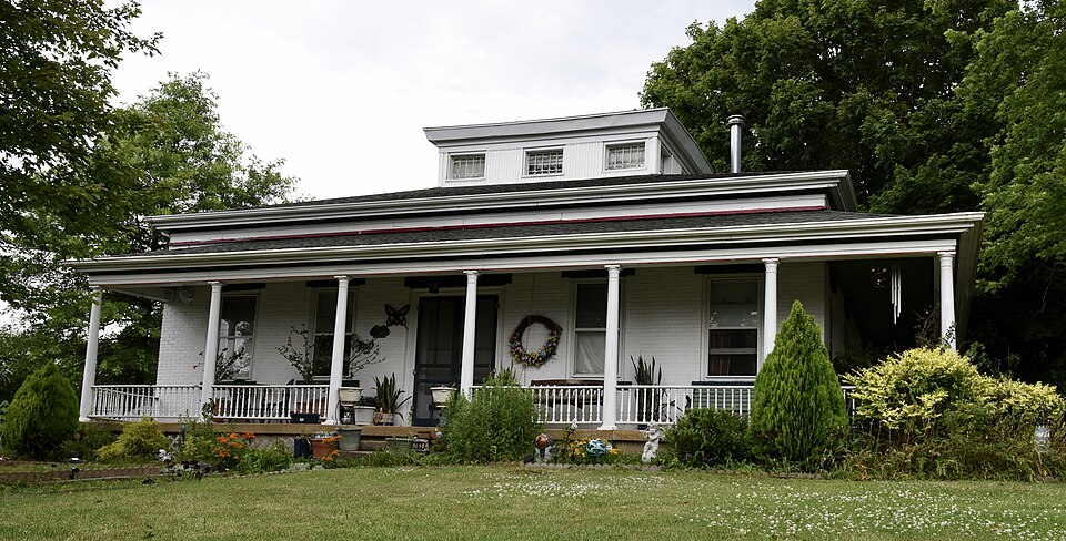
Photograph of Hiram Palmer House
Photograph by Jim Roberts, CC BY-SA 4.0. Via Wikimedia Commons.

Hiram Palmer House

Listed on the National Register of Historic Places in 1999.

From the record

“The Hiram Palmer House is a historic house located at 703 East Fort Street in Farmington, Illinois. Hiram and Philynder Palmer built the house in 1851-52 but sold it the year it was completed.”

Wikipedia article Hiram Palmer House, CC BY-SA 4.0.

One of 38 National Register listings published here for Fulton County · listed in 1999 · category: Building.

Sources: the Wikipedia article · the case file at the National Archives · the National Register database, National Park Service

The listing

  • What is counted as historic. The nomination lists 1 building as contributing to the listing.
  • Listed as. Palmer, Hiram, House - the National Register files a house under its owner's surname.
  • Address. 703 E. Fort St., Farmington, 61531
  • When was it listed? May 1999
  • Category. building
  • Township. Farmington township
  • National Register reference number. 99000589 - the number the National Park Service assigned this property when it was listed, and the key its nomination file is catalogued under at the National Archives.

The ground it stands on

8,301 words

The chapter on Farmington Township in History of Fulton County, Illinois;, published 1879 names Farmington. This is what it says, exactly as the scans read.

Seth Littler, a brother-in-law of the Marchants, lived in the township a few months in the spring and summer of the year 1827. He then left in company with some of his relatives for the Galena lead mines, which just at that time were causing such excitement. Mr. Littler, however, returned the same year and located near Canton, which at that time was a very small beginning for a town. He died that fall about the time Jonah Marchant settled in Farmington. The creek that heads south of Farmington was named in honor of Mr. Littler.

Passage source: History of Fulton County, Illinois;, published 1879.

Abraham Marchant was the next pioneer to venture so far from civilization. He arrived June 27, 1828, and had to build a small house, one suitable for a smoke-house, before he could have a place to unload his goods from the wagon. He built a better cabin in the fall of the same year, in which he lived until 1835, when he and his brother Jonah each erected a one-story brick dwelling upon the northwest quarter of sec. 13. This property, with several other pieces of land they owned, has passed into other hands. This was called the Marchant settlement for many years, until it was superceded bv the village of Farmington, which Avas started in the year 1830 or*1837.

Passage source: History of Fulton County, Illinois;, published 1879.

Machine-read from a century-old scan, so expect the errors a machine makes: misspelled names, dropped words, stray characters.

Read the whole chapter on Farmington Township - 8,301 words on its settlement, mills, schools and churches.

Storms near this property

33 since 1995

Regional context, not property-specific evidence. The National Weather Service names Farmington, the town this property stands in, in 33 storm reports between 1995 and 2025: 15 thunderstorm wind, 13 hail, 2 flash flood, 1 tornado. The reports record 1 injury. Each account below is quoted exactly as the forecast office filed it, from the NOAA Storm Events Database, and each date opens the federal record of that event.

WhenEvent Place namedHarm What the report says
August 2001Thunderstorm WindFarmington1 hurtNumerous trees and power lines were blown down. Three of the trees were 30" in diameter, with several limbs reaching 16" in diameter. A boat on a lake 1 mile north of Farmington was blown off the water onto shore. A fisherman suffered minor injuries to his back.
June 1998Tornado (F1)Farmington$670,000A tornado touched down on the west side of Farmington and travelled to the east southeast. It first severely damaged a lumberyard, ripping off the roof of a large storage facility. Then as it moved into the downtown area, several buildings sustained damage to the back walls, as well as, roof damage. Also, several projectiles were found in this area (2x4s driven into the ground). A block down the road a house lost its roof and then as the tornado moved into the east side of town, the second story of a brick building was demolished. Across the street at the high school, a large garage was destroyed which damaged several vehicles. Also, the gymnasium sustained significant roof and water damage and the new press box and bleachers at the football stadium were destroyed. Damage at the high school was estimated around $400,000. As the tornado lifted on the east side of town, it blew down or damaged numerous trees. No deaths or injuries were reported.
May 2013Thunderstorm WindFarmington$25,000Several large trees were uprooted and a few power lines were knocked down.
June 2009Thunderstorm WindFarmington$20,000A garage was blown off its foundation in Farmington.
June 2010Thunderstorm WindFarmington$10,000A few small trees were snapped off by thunderstorm winds.
August 1999Thunderstorm WindFarmington$10,000Several large tree limbs and power lines were blown down.
August 2008Thunderstorm WindFarmington$8,000Several large trees were blown down.
June 2018Thunderstorm WindFarmington$6,000A few trees were blown down in Farmington.
August 2025LightningFarmington$2,000Lightning struck a utility pole and caused it to shatter at the intersection of North East Street and East Court Street in Farmington.
May 2024Thunderstorm WindFarmington-The emergency manager estimated a wind gust of 60mph in Farmington.
May 2023Thunderstorm WindFarmington-A tree was blown down across IL-116 west of Farmington.
August 2023FloodFarmington-A few roadways in Farmington were covered in water.
August 2023Thunderstorm WindFarmington-Emergency Manager estimated wind speeds of 60 miles per hour.
March 2017Thunderstorm WindFarmington-A large object was blown onto a house.
June 2010Flash FloodFarmington-Around 1.50 of rain fell between 0700 and 0800 CST on top of already saturated ground. This produced rapid flash flooding in northern Fulton County. In the village of Farmington a foot of water covered the streets in the downtown. Most rural roads in the northern part of the county were flooded as drainage ditches were overflowing.
May 2008HailFarmington-One inch diameter hail covered the ground.
September 2008Flash FloodFarmington-High water was flowing across Route 116 near Farmington.
April 2006Thunderstorm WindFarmington-A mobile home was blown off its foundation, siding was damaged and numerous trees and power lines were blown down.
June 2005Thunderstorm WindFarmington-8 inch diameter tree blown down across power lines.
June 1998Thunderstorm WindFarmington-Thunderstorm winds blew down numerous trees, tree limbs, and power lines in Farmington and Norris. Also, the winds destroyed a barn and damaged a large storage building. No damage estimate was available.
June 1995Thunderstorm WindFarmington-A severe thunderstorm downed trees and power lines in Farmington.
April 2025HailFarmington-no account filed
March 2024HailFarmington-no account filed
May 2024HailFarmington-no account filed
April 2023HailFarmington-no account filed
September 2022HailFarmington-no account filed
July 2017HailFarmington-no account filed
November 2016HailFarmington-no account filed
August 2015HailFarmington-no account filed
April 2015HailFarmington-no account filed
August 2012HailFarmington-no account filed
April 2006HailFarmington-no account filed
August 2004HailFarmington-no account filed

Every storm recorded in Fulton County

Map coverage status

No historic map-sheet match is published for this property yet. That does not mean no map exists. This record needs a coordinate-quality review before it can be joined to a sheet boundary. Browse the county's mapped places while that work is pending.

Sources for this property

National Archives recordThe nomination case file for reference 99000589 in Record Group 79.
Wikipedia articleCommunity-written account of this property, licensed CC BY-SA.
Fulton CountyAll 38 listed properties in this county.

Provenance

  • Listing record. National Park Service National Register of Historic Places, listed-properties dataset, current to 2026-05-22.
  • Map join. Address geocoded through the United States Census geocoder, then tested against the published boundary of every sheet in the USGS Historical Topographic Map Collection.
  • How this page is made. Listing fields come from federal records; map-sheet coverage is a labelled coordinate-to-boundary calculation, not a source-field claim.
  • Storms. NOAA National Centers for Environmental Information, Storm Events Database https://www.ncei.noaa.gov/stormevents/ A work of the United States government, no copyright under 17 U.S.C. 105. Narratives are quoted verbatim from the National Weather Service report and are not edited or summarised.