 Block
From the record
14 National Register listings published here.
Sources: the National Register database, National Park Service
80 topographic sheets cover 52 settlements here, and 14 properties are on the National Register of Historic Places.
14 National Register listings published here.
Sources: the National Register database, National Park Service
Every property in this county listed on the National Register of Historic Places, with the year it was listed and the federal nomination document.
| Photograph | Property | Type | Listed | Reference |
|---|---|---|---|---|
 | Bedford Courthouse Square Historic District | district | 1995 | 95000704 |
| Bedford Northside Residential Historic District | district | 2024 | 100010741 | |
| Bedford Southern Indiana Railroad Passenger Depot | building | 2021 | 100006563 | |
| Green Hill Cemetery | site | 2025 | 100011863 | |
 | Helton-Mayo Farm | district | 1995 | 95000709 |
 | Indiana Limestone Company Building | building | 1993 | 93001412 |
 | Madden School | building | 2000 | 00000673 |
 | Mitchell Downtown Historic District | district | 1997 | 97001175 |
 | Mitchell Opera House | building | 1981 | 81000020 |
 | C. S. Norton Mansion | building | 1976 | 76000026 |
 | Otis Park and Golf Course | district | 2002 | 02001560 |
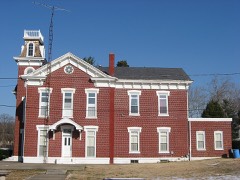 | William A. Ragsdale House | building | 2002 | 02001565 |
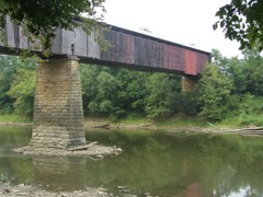 | Williams Bridge | structure | 1981 | 81000018 |
 | Zahn Historic District | district | 1998 | 98001100 |
Every wildfire the federal occurrence database records inside this county: 60 of them, burning about 154 acres. 3 started naturally and 6 were recorded as arson. Each settlement page carries the fires within five miles of it.
| Reported cause | Fires |
|---|---|
| Debris and open burning | 28 |
| Recreation and ceremony | 7 |
| Missing data/not specified/undetermined | 6 |
| Arson/incendiarism | 6 |
| Equipment and vehicle use | 4 |
| Misuse of fire by a minor | 3 |
| Natural | 3 |
| Smoking | 2 |
| Other causes | 1 |
The five largest, by the area the report gives. None of them was recorded as arson.
| Date | Cause | Size | Reported by | Name on the report |
|---|---|---|---|---|
| 8 November 1999 | Equipment and vehicle use | 15 acres | Hoosier National Forest | PROSPECT |
| 29 February 2004 | Debris and open burning | 15 acres | Hoosier National Forest | SHAWSWICK FIRE |
| 22 June 2012 | Equipment and vehicle use | 10 acres | Hoosier National Forest | BALDWIN |
| 7 March 2000 | Debris and open burning | 10 acres | Hoosier National Forest | GUTHERIE TWO |
| 12 April 2018 | Missing data/not specified/undetermined | 8.0 acres | Hoosier National Forest | FIBERTECH |
| 17 March 2005 | Debris and open burning | 8.0 acres | Hoosier National Forest | MAPLE RIDGE FIRE |
| 22 March 2014 | Debris and open burning | 5.5 acres | Hoosier National Forest | BACK CREEK |
| 16 March 2005 | Debris and open burning | 5.0 acres | Hoosier National Forest | CLARK SMITH RD. FIRE |
Every settlement page carries the fires within five miles of it - see the settlement index below.
The NOAA Storm Events Database holds 332 reports for this county, causing 4 deaths, 59 injuries and about $49,919,000 in recorded property damage. Each settlement page carries the reports that name it.
| Kind of event | Reports |
|---|---|
| Thunderstorm Wind | 154 |
| Hail | 80 |
| Flood | 33 |
| Flash Flood | 30 |
| Tornado | 27 |
| Lightning | 3 |
| Funnel Cloud | 3 |
| Heavy Rain | 2 |
The most serious of them, by death, then injury, then recorded damage. The accounts are quoted exactly as the forecast office filed them.
| When | Event | Place named | Harm | What the report says |
|---|---|---|---|---|
| March 2026 | Flood | Lawrenceport | 2 killed, $20,000 | The East Fork White River, while cresting in moderate flood stage in southeastern Lawrence County, swept away a truck carrying two people during the overnight early on the 9th. Both occupants were found submerged in 8 feet of water west of the Tunnelton community near the intersection of Earl Road and Lawrenceport Road. |
| June 1990 | Tornado (F4) | not stated | 1 killed, 51 hurt, $2,500,000 | no account filed |
| March 2006 | Flood | Bedford | 1 killed, $100,000 | no account filed |
| April 1994 | Tornado (F1) | Mitchell | 3 hurt, $50,000 | A small tornado briefly touched down and destroyed a mobile home. |
| April 1994 | Tornado (F1) | Bryantsville | 2 hurt, $500,000 | A small tornado briefly touched down heavily damaging four homes and causing minor damage to 11 homes. Also numerous trees and power lines were knocked down. |
| March 2009 | Tornado (EF3) | Fayetteville | 1 hurt, $420,000 | This brief but powerful tornado had a steady track to the east-northeast, creating damage consistent of an EF3 strength tornado. A rating of EF3 corresponds with winds of 136 to 165 MPH. The maximum width of the tornado was approximately 1/8 mile. It completely destroyed the above ground portions of two homes, seriously damaged a trailer home, and created lesser damage to two other homes. It picked a full size school bus up, turned it around and onto its side, and moved it uphill onto the foundation of what had been an occupied home. The damage estimate is very rough. |
| May 1999 | Lightning | O Olitic | 1 hurt, $150,000 | no account filed |
| June 2008 | Tornado (EF1) | Popcorn | 1 hurt, $120,000 | The tornado began in Greene County at 1010 EST approximately three miles east of Bloomfield, 200 meters north of Ore Branch Road, and 200 meters south of State Road 54. The tornado tracked 11.32 miles to the southeast before exiting Greene County. The tornado exited Greene County at 1027 and entered Lawrence County while passing through a grove of trees located 4,000 feet east of State Road 54, 4,000 feet north of State Road 54, and 6,500 feet west of Popcorn Church Road. The tornado continued to the southeast in Lawrence County for 15.83 miles until lifting at 1040 EST. The tornado was rated EF-1 while in both counties with a width of 100 yards. The total time on the ground was 40 minutes and 27.15 miles. Residences, trees, and barns were damaged in both counties with fifty thousand dollars of damage occurring in Greene County and 120,000 thousand dollars in damage occurring in Lawrence County. A school was also damaged in Greene County. One male was injured with a broken foot when debris landed on his foot in Lawrence County. Wind speeds were around 100 miles per hour. |
| April 1974 | Tornado (F3) | not stated | $25,000,000 | no account filed |
| June 2008 | Flood | River Vale | $15,000,000 | Flooding occurred along the East Fork White River in Lawrence County, including in the Rivervale, Bedford, and Williams areas due to heavy rain. |
| June 1990 | Tornado (F4) | not stated | $2,500,000 | no account filed |
| April 2025 | Flash Flood | Silverville | $500,000 | Numerous roads closed due to flash flooding across southeastern Indiana. Exact details were never known, but over 30 water rescues were performed. |
| April 1963 | Tornado (F3) | not stated | $250,000 | no account filed |
| February 1959 | Tornado (F2) | not stated | $250,000 | no account filed |
| May 2011 | Tornado (EF3) | Erie | $150,000 | National Weather Service storm survey teams determined an EF-3 tornado struck near Bedford, damaging or destroying several buildings in a 6.8 mile long swath up to a quarter mile wide. |
| June 2023 | Thunderstorm Wind | Bedford | $125,000 | Numerous trees and powerlines downed by thunderstorm wind gusts in Bedford and across the county. Over 6000 power outages caused by the storm across the county. |
| November 2017 | Tornado (EF1) | Springville | $125,000 | This EF1 tornado produced damage north of Springville. Over a dozen structures had minor to moderate damage with the worst damage being two destroyed mobile homes and a garage being destroyed. Dozens of hardwood trees were either snapped off or uprooted. |
| March 2025 | Tornado (EF0) | Silverville | $120,000 | A weak tornado began three-quarters of a mile southwest of the Silverville community, and tracked in an overall east-northeast direction before ending about 1.5 miles west-northwest of the Feldun Purdue Agircultural Center. Several farm buildings were impacted amid sporadic tree damage through and east-northeast of Silverville. The tornado then tracked through wooded areas north of Indiana Route 158 before impacting mostly wooded areas on the north side of the Fayetteville area. Southwest of Old Farm Road an old shed was destroyed along with some minor barn roof damage. The tornado skipped around causing sporadic damage between Old Farm Road and Tripleton Pike before ending a quarter-mile east-southeast of the intersection of Tripleton Pike and Indiana Creek Camp Road.||There was clear evidence of trees blown to the southwest along the northern portion of Old Farm Road, but otherwise it was often difficult to differentiate straight line wind and tornado damage. The vortex also likely skipped along its track, and may have been just off the ground for some of the path. Maximum winds estimated at 80 mph. |
| May 2024 | Thunderstorm Wind | Sand Pit | $100,000 | A large metal warehouse building sustained damage as thunderstorm wind entered|the structure under an awning on the south side of the building. Nearby tree damage was also noted. |
| March 2017 | Tornado (EF2) | Bond | $100,000 | This EF-2 tornado, with maximum wind speeds of 130 mph, collapsed 3 metal chicken barns and damaged or destroyed some outbuildings. The tornado continued southeast into NWS WFO Louisville's area of responsibility. |
| April 2006 | Tornado (F1) | Mitchell | $100,000 | Homes and businesses were damaged by a tornado that touched down briefly in Mitchell on the evening of 2 April 2006. |
| April 1996 | Tornado (F0) | Bedford | $100,000 | no account filed |
| September 2000 | Lightning | Bedford | $80,000 | no account filed |
| April 1995 | Thunderstorm Wind | not stated | $75,000 | Thunderstorm winds tore off part of the roof of a home in Orleans. An airplane hangar also received some damage from the winds. Another home in Orleans had a tree fall on the roof. A store window was also blown in. |
| March 2025 | Tornado (EF0) | Avoca | $70,000 | A short lived tornado began in a ravine about 0.4 of a mile east-northeast of the intersection of Indiana Routes 37 and 54. Tracking to the north-northeast, the majority of the damage was to the west of the southwest corner of Kentucky Hollow Road where a shed was completely destroyed along with significant damage to the residence's porch. The house saw some shingle damage with insulation blown on all 4 sides of the structure, while tornadic winds blew in the garage and partially blew out the cinder block foundation. The track ended on the west side of the Needmore community. Maximum winds estimated at 85 mph. |
| November 2013 | Tornado (EF1) | Bedford | $70,000 | At 1557EST, this EF-1 tornado touched down one mile west-northwest of Bedford and tracked across the north side of Bedford. Most of the funnel was aloft, but intermittently touched down several times which split and uprooted trees, knocked down power lines, and caused some roof and structural damage to several homes. The worst of the damage was along M, N, and O Streets on the north side of Bedford. Several witnesses observed one or two small, narrow funnels dropping up and down from a wide wall cloud. Many witnesses described a strong pressure change, a green sky, and a roar as the tornado went through. The tornado lifted for good at 1559EST 1.5 miles northeast of Bedford. NWS Louisville conducted this survey. |
| April 2026 | Thunderstorm Wind | Fayetteville | $50,000 | Thunderstorm wind gusts downed dozens of trees across Lawrence County. One tree was downed onto powerlines. |
| April 2020 | Thunderstorm Wind | Fayetteville | $50,000 | Significant damage in Fayetteville due to thunderstorm wind gusts. Power lines are down, roofs badly damaged, and large trees are down. Metal chimney at the Indian Creek volunteer fire department is bent. A 77 mph wind gust was measured via a personal weather station. |
| February 2008 | Thunderstorm Wind | Mitchell | $50,000 | A house had the windows shattered in it due to damaging thunderstorm winds. The storm also detached a wrap-around porch, leveled a garage, and destroyed a shelter house. A Harley motorcycle was smashed in the leveled garage. The roof of the house was damaged when it was picked up and moved two inches from its original location. |
| January 2008 | Thunderstorm Wind | Bedford | $50,000 | Part of a roof was blown off of a building due to damaging thunderstorm winds. A tree fell on the screened porch of another residence. Two small barns were destroyed due to the winds. Windows were broken out of a van. At least 30 windows were blown out around town. At another residence shingles were ripped from the house. |
| November 2005 | Tornado (F1) | Coveyville | $50,000 | An F1 tornado touched down briefly in northern Lawrence county, damaging two homes. This tornado came from the same supercell that spawned an F3 tornado in Daviess and Martin counties. The supercell would go on to produce an additional F3 in Bartholomew and Shelby counties later in the afternoon. |
| May 2002 | Flash Flood | Bedford | $50,000 | SR 58 flooded in three different locations |
| May 2002 | Flash Flood | Countywide | $50,000 | no account filed |
| February 2019 | Flood | Springville | $45,000 | Creek was severely out of its banks and was flooding yards and flooding vehicles due to heavy rainfall. |
| March 2009 | Tornado (EF0) | Bedford | $45,000 | A tornado, rated EF0, caused very brief damage along North Jackson Street in Lawrence County. Damage was mainly limited to a construction trailer, a metal corrugated garage rooftop, removal of roof tiles from a couple homes, and broken tree branches. The damage estimate is very rough. |
| April 2025 | Tornado (EF0) | Holtonville | $30,000 | This eleventh and final tornado to impact central Indiana touched down very briefly in a rural area southeast of Heltonville, immediately northeast of the intersection of Indiana Route 446 and Mundell Church Road. Here, damage was caused to a pole barn with debris blown to the northwest: the south facing wall was the only wall left standing with damage from the barn to the west of the structure. Two 2x4s were also embedded into the ground facing to the west-northwest. As the barn's anchoring was under code, peak wind gusts were estimated at only 80 mph. |
| April 2025 | Flash Flood | Williams | $25,000 | State Road 58 was closed near Back Creek Road due to flash flooding. Numerous other roads closed. Total rainfall was between 1.2 and 2.9 inches. |
| July 2004 | Thunderstorm Wind | Bedford | $25,000 | Several trees were downed and a gas station canopy was damaged. |
| March 1955 | Tornado (F2) | not stated | $25,000 | no account filed |
| March 2017 | Tornado (EF1) | Mitchell | $22,000 | This EF-1 tornado, with winds up to 110 mph, uprooted trees at the start of the path. Uphill, a barn's roof was lofted nearly 100 yards to the northeast. The associated house had the majority of the roof lofted and thrown over 100 yards to the northeast. The east wall of the house and garage displayed widespread mud and insulation splatter. Insulation also splattered inside the mailbox from an east wind component. A lamp post was broken, laying westward. |
| June 2013 | Thunderstorm Wind | Dark Hollow | $21,000 | A tree was downed on a house, cars were damaged, and a garage was damaged due to damaging thunderstorm wind gusts. An outbuilding was also destroyed on Twin Pond Road. |
| April 2025 | Thunderstorm Wind | Shawswich | $20,000 | Numerous reports of trees downed by thunderstorm wind gusts across the county with large volumes of debris in the road. |
| May 2022 | Thunderstorm Wind | Judah | $20,000 | Thunderstorm winds damaged buildings across the county with no specific location noted. |
| June 2008 | Thunderstorm Wind | Murdock | $20,000 | Houses and trees sustained damage due to thunderstorm winds. |
| February 1999 | Thunderstorm Wind | Bedford | $20,000 | no account filed |
| November 2017 | Thunderstorm Wind | Springville | $18,000 | Widespread damage across portions of Springville near Popcorn Road due to damaging thunderstorm wind gusts. A mobile home was damaged, a trailer was knocked over, and numerous trees were damaged. |
| March 2026 | Thunderstorm Wind | Bedford | $15,000 | Thunderstorm wind gusts blew out a transformer and downed at least one power pole. |
| March 2026 | Thunderstorm Wind | Hartleyville | $15,000 | Trees and power lines downed by thunderstorm wind gusts near the intersection of US Highway 50 and State Road 37. |
| June 2025 | Thunderstorm Wind | O Olitic | $15,000 | Trees and utility lines were blown down by thunderstorm wind gusts. |
| October 2020 | Thunderstorm Wind | Mitchell | $15,000 | Tree was blown onto an apartment by thunderstorm wind gusts. |
| July 2012 | Thunderstorm Wind | Judah | $15,000 | Part of a roof was peeled off at the Hillcrest Shops strip mall near the intersection of State Route 37 and Sieboldt Quarry Road in Judah due to damaging thunderstorm wind gusts. |
| May 2011 | Tornado (EF1) | Bond | $15,000 | An EF-1 tornado crossed into Lawrence County about three miles south, southwest of Bond. This tornado then tracked northeast for approximately 1.7 miles before leaving Lawrence County about two miles southwest of Bono. The tornado then continued into Washington County. In total, this tornado was on the ground for approximately 3.2 miles before lifting. In Lawrence County, minor damage was done to a homestead and numerous trees were downed. |
| May 2011 | Thunderstorm Wind | Buddha | $15,000 | A barn roof was reported to be blown off due to damaging thunderstorm wind gusts. Multiple trees were reported down as well, including a 14-inch diameter tree. |
| July 2011 | Thunderstorm Wind | O Olitic | $15,000 | Trees and utility lines were blown down in Oolitic due to damaging thunderstorm wind gusts. One tree crashed into a home. |
| June 2009 | Lightning | Needmore | $15,000 | The Bedford Daily Times Mail reported that thunderstorm lightning sparked a house fire on Old Indiana 37 just north of Oolitic. Some electrical damage was noted in the home. The time and location of this event are estimated. |
| May 2008 | Flash Flood | Patton Hill | $15,000 | Part of State Road 54 near Avoca was reported to be damaged with parts of the road moving in the flood waters. Water was also approaching a few homes. This flash flooding was caused by heavy rain. |
| February 2008 | Thunderstorm Wind | Mitchell | $12,000 | A modular home moved 5 feet off its foundation due to damaging thunderstorm winds. A nearby barn was also damaged during this event. A board was wedged three feet into the ground due to the winds. |
| March 2008 | Flood | River Vale | $12,000 | Flooding occurred along the East Fork White River in Lawrence County, including near Rivervale, due to heavy rain. Flooding continued until April 9th at 12:40. Multiple roads were flooded due to heavy rain. |
| March 2008 | Flood | Coxton | $12,000 | Flooding occurred along the East Fork White River in Lawrence County, including near Bedford, due to heavy rain. Flooding continued until April 5th at 14:50. Multiple roads were flooded due to heavy rain. |
| March 2008 | Flood | Williams | $12,000 | Flooding occurred along the East Fork White River in Lawrence County, including near Williams, due to heavy rain. Flooding continued until April 6th at 07:15. Multiple roads were flooded due to the heavy rain. |
The Survey's mineral resources record lists 66 workings inside this county. 14 still produce and 52 are closed or unrecorded. Each settlement page carries the workings within five miles of it.
| Commodity | Workings |
|---|---|
| Iron | 32 |
| Limestone, Dimension | 15 |
| Aluminum | 8 |
| Stone, Crushed/Broken | 5 |
| Limestone, General | 2 |
| Zinc | 1 |
| Sulfur | 1 |
| Fluorine-Fluorite | 1 |
| Flagstone | 1 |
| Sand and Gravel, Construction | 1 |
The least common of them first, because a county's hundredth gravel pit says nothing its first ten did not.
| Where | Site | Commodity | Status | Recorded |
|---|---|---|---|---|
| Johnson Quarry | Flagstone | Producer | ||
| Lawrence Co. Hwy. Dept. | Sand and Gravel, Construction | Producer | ||
| Sphalerite Occurrence Z81 | Zinc, Sulfur | Occurrence | Sphalerite | |
| Unnamed Fluorite Occurrence | Fluorine-Fluorite | Occurrence | Fluorite | |
| Baalbeck Quarry | Limestone, General | Past Producer | ||
| Number 3 Needmore Quarry | Limestone, General | Past Producer | ||
| Bedford Ground Limestone Plant | Stone, Crushed/Broken | Producer | ||
| Bedford Quarry and Mill | Stone, Crushed/Broken | Producer | ||
| Mitchell Quarry and Mill | Stone, Crushed/Broken | Producer | ||
| Sieboldt Quarry | Stone, Crushed/Broken | Producer | ||
| V. I. Grissom Quarry | Stone, Crushed/Broken | Producer | ||
| North Gardner Mine | Aluminum | Past Producer | ||
| North Gardner Mine | Aluminum | Past Producer | ||
| Pennsylvania Salt Company Mine | Aluminum | Past Producer | ||
| Pennsylvania Salt Company Mine | Aluminum | Past Producer | ||
| South Gardner Mine | Aluminum | Past Producer | ||
| South Gardner Mine | Aluminum | Past Producer | ||
| Wilson Halloysite Deposit | Aluminum | Past Producer | ||
| Wilson Halloysite Deposit | Aluminum | Past Producer | ||
| Dark Hollow Quarry | Limestone, Dimension | Past Producer | ||
| Dickenson Plant | Limestone, Dimension | Past Producer | ||
| Diehl Hollow Quarry | Limestone, Dimension | Past Producer | ||
| Elliott Stone Company, Inc. | Limestone, Dimension | Producer | ||
| Eureka Quarry | Limestone, Dimension | Past Producer | ||
| Evans Quarry | Limestone, Dimension | Producer | ||
| Guthrie Quarry | Limestone, Dimension | Producer | ||
| Joyner Plant | Limestone, Dimension | Producer | ||
| Klondike Quarry | Limestone, Dimension | Past Producer | ||
| Mcmillan Plant | Limestone, Dimension | Producer | ||
| Mcshain Quarry | Limestone, Dimension | Producer | ||
| P.M. and B. Quarry | Limestone, Dimension | Producer | ||
| Peerless Quarry | Limestone, Dimension | Past Producer | ||
| Reed Quarry | Limestone, Dimension | Past Producer | ||
| Walsh Quarry | Limestone, Dimension | Prospect | ||
| Unnamed Mine | Iron | Past Producer | ||
| Unnamed Mine | Iron | Past Producer | ||
| Unnamed Mine | Iron | Past Producer | ||
| Unnamed Mine | Iron | Past Producer | ||
| Unnamed Mine | Iron | Past Producer | ||
| Unnamed Mine | Iron | Past Producer | ||
| Unnamed Mine | Iron | Past Producer | ||
| Unnamed Mine | Iron | Past Producer | ||
| Unnamed Mine | Iron | Past Producer | ||
| Unnamed Mine | Iron | Past Producer | ||
| Unnamed Mine | Iron | Past Producer | ||
| Unnamed Mine | Iron | Past Producer | ||
| Unnamed Mine | Iron | Past Producer | ||
| Unnamed Mine | Iron | Past Producer | ||
| Unnamed Mine | Iron | Past Producer | ||
| Unnamed Mine | Iron | Past Producer | ||
| Unnamed Prospect | Iron | Occurrence | ||
| Unnamed Prospect | Iron | Occurrence | ||
| Unnamed Prospect | Iron | Occurrence | ||
| Unnamed Prospect | Iron | Occurrence | ||
| Unnamed Prospect | Iron | Occurrence | ||
| Unnamed Prospect | Iron | Occurrence | ||
| Unnamed Prospect | Iron | Occurrence | ||
| Unnamed Prospect | Iron | Occurrence | ||
| Unnamed Prospect | Iron | Occurrence | ||
| Unnamed Prospect | Iron | Occurrence | ||
| Unnamed Prospect | Iron | Occurrence | ||
| Unnamed Prospect | Iron | Occurrence | ||
| Unnamed Prospect | Iron | Occurrence | ||
| Unnamed Prospect | Iron | Occurrence | ||
| Unnamed Prospect | Iron | Occurrence | ||
| Unnamed Prospect | Iron | Occurrence |
Named settlements recorded in the Geographic Names Information System, each with the topographic sheets covering it. Villages, hamlets and abandoned places alike. Each is shown with the nearest named watercourse or landform and the survey quadrangle it falls on.
Pleasant Run township · 47421 · On Bowlen Branch · Bartlettsville quadrangle
18 sheets, 1934 to 1990
Guthrie township · 47421 · On Crawford Creek · Bedford East quadrangle
17 sheets, 1934 to 1990
Indian Creek township · 47421 · On Adamson Branch · Bedford West quadrangle
21 sheets, 1935 to 1993
Indian Creek township · 47421 · In Dark Hollow · Oolitic quadrangle
22 sheets, 1935 to 1990
Shawswick township · 47421 · On Gulletts Creek · Oolitic quadrangle
22 sheets, 1935 to 1990
Shawswick township · 47421 · On Spider Creek · Bedford East quadrangle
17 sheets, 1934 to 1990
Guthrie township · 47421 · Near Tunnel Hill · Tunnelton quadrangle
15 sheets, 1934 to 1990
Spice Valley township · 47446 · Near Toliver Ridge · Georgia quadrangle
14 sheets, 1949 to 1993
Spice Valley township · 47446 · Near Burton Hollow · Georgia quadrangle
14 sheets, 1949 to 1993
Indian Creek township · 47421 · Near Diehl Hollow · Oolitic quadrangle
22 sheets, 1935 to 1990
Guthrie township · 47421 · On South Fork Crawford Creek · Tunnelton quadrangle
15 sheets, 1934 to 1990
Marion township · 47446 · Near Rariden Hill · Bedford West quadrangle
21 sheets, 1935 to 1993
Shawswick township · 47421 · On Adamson Branch · Bedford West quadrangle
21 sheets, 1935 to 1993
Marion township · 47421 · On Leatherwood Creek · Bedford West quadrangle
21 sheets, 1935 to 1993
Marion township · 47446 · Near Rariden Hill · Bedford East quadrangle
17 sheets, 1934 to 1990