 Block
From the record
6 National Register listings published here.
Sources: the county history on the Internet Archive · the National Register database, National Park Service
41 topographic sheets cover 19 settlements here, and 6 properties are on the National Register of Historic Places.
6 National Register listings published here.
Sources: the county history on the Internet Archive · the National Register database, National Park Service
Every property in this county listed on the National Register of Historic Places, with the year it was listed and the federal nomination document.
| Photograph | Property | Type | Listed | Reference |
|---|---|---|---|---|
 | George Ade House | building | 1976 | 76000014 |
 | Goodland-Grant Township Public Library | building | 2004 | 04001103 |
 | McCairn-Turner House | building | 1994 | 94000232 |
 | Newton County Courthouse | building | 2008 | 08000742 |
 | Scott-Lucas House | building | 2003 | 03000544 |
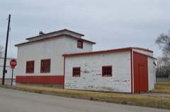 | Seller's Standard Station and Pullman Diner | building | 2014 | 14000808 |
The NOAA Storm Events Database holds 218 reports for this county, causing 2 deaths, 29 injuries and about $6,008,000 in recorded property damage. Each settlement page carries the reports that name it.
| Kind of event | Reports |
|---|---|
| Thunderstorm Wind | 101 |
| Hail | 62 |
| Tornado | 26 |
| Flash Flood | 14 |
| Flood | 7 |
| Heavy Rain | 6 |
| Lightning | 1 |
| Funnel Cloud | 1 |
The most serious of them, by death, then injury, then recorded damage. The accounts are quoted exactly as the forecast office filed them.
| When | Event | Place named | Harm | What the report says |
|---|---|---|---|---|
| March 2026 | Tornado (EF3) | (C98) Lake Village Airport | 2 killed, 10 hurt | A destructive EF-3 tornado with estimated peak winds of 160 mph impacted portions of Newton and northwest Jasper Counties, most notably the community of Lake Village. After forming and causing EF-3 damage in Kankakee County, Illinois, this tornado crossed into Newton County between W 800 N Road and W 900 N Road near N 650 W Road. Upon entering the county, the tornado destroyed multiple outbuildings and significantly damaged multiple homes. On N 600 W Road, multiple homes were completely destroyed with debris blown clear of the foundations, consistent with EF-3 caliber winds. Nearby forested areas had almost all trees snapped or uprooted with some trees remaining standing with only stubs of a few large branches remaining, likely due to extensive lifted debris. Multiple homes were damaged, and a farm outbuilding was destroyed along N 500 W Road and along and near N 400 W Road. As the tornado crossed US-41 into the south side of Lake Village, it widened to approximately 1100 yards while damaging the roof and canopy of a gas station and a nearby retail building. Further north along N 300 W Road, multiple blocks of homes had significant roof damage and almost all trees were uprooted or snapped. The tornado continued eastward into a wooded area near the Lugene Links Golf Course, where a continuous corridor of trees was entirely uprooted. As the tornado neared W 950 N Road and N 150 W Road, a few homes were damaged, and a farm outbuilding was completely destroyed. The tornado continued to produce damage to trees and outbuildings as it traveled northeastward through mainly rural portions of northern Newton County and northern portions of Roselawn. The tornado continued into Jasper County and dissipated shortly thereafter. It was on the ground for over 35 miles and, at its peak, spanned a half mile in diameter. The storm destroyed numerous homes and resulted in around a dozen injuries and three fatalities: one in Kankakee County and the other two near Lake Village. |
| March 1976 | Tornado (F3) | not stated | 7 hurt, $250,000 | no account filed |
| April 1962 | Tornado (F2) | not stated | 5 hurt, $25,000 | no account filed |
| July 1987 | Tornado (F2) | not stated | 3 hurt, $2,500,000 | no account filed |
| April 1963 | Tornado (F4) | not stated | 2 hurt | no account filed |
| May 1954 | Tornado (F1) | not stated | 1 hurt, $25,000 | no account filed |
| June 2013 | Thunderstorm Wind | Roselawn Airstrip Ar | 1 hurt | Multiple power poles, trees, and limbs up to 18 inches in diameter were blown down on Route 55 between 500N and 800N. A motorist was trapped when power lines fell onto a vehicle on Route 55. |
| January 2008 | Flash Flood | Marocco | $1,000,000 | All county roads south of SR 114 were closed due to flooding. The south end of Goodland was evacuated due to high water. A bridge was damaged by flood waters on 1100 South near 550 East. Several roads had damage to the pavement and shoulders. Kentland measured 3.96 inches of rainfall. |
| September 2008 | Flood | Thayer | $1,000,000 | Extensive flooding closed roads and inundated large areas near the river. A levee break caused extensive flooding of homes in Sumava Resorts. |
| February 2008 | Flash Flood | Effner | $500,000 | Widespread flooding was reported across Newton County with many roads flooded and impassible. Morocco measured 2.55 inches of rainfall, Kentland measured 2.44 inches and Lake Village measured 2.37 inches. |
| November 2013 | Tornado (EF0) | Goodland | $250,000 | The tornado touched down in Goodland causing several large grain bins to cave in on themselves with some of the surrounding scaffolding collapsing. This portion of the storm was consistent with high-end EF-0 damage with estimated winds to 85 mph. The tornado continued into Jasper County around 1:29 PM CST where it further intensified to EF-1. |
| July 2010 | Lightning | Kentland | $100,000 | Lightning struck a barn and fire destroyed it. |
| April 2001 | Thunderstorm Wind | Enos | $75,000 | One building completely leveled by straight line winds. |
| June 2014 | Tornado (EF1) | Thayer | $60,000 | A tornado started near Colfax St. and tracked through the south side of Shelby, through DeMotte, and ended slightly east of N. 600W Rd. A large barn was completely destroyed, and damage was done to houses in both Shelby and DeMotte. In addition, numerous hardwood trees were snapped and uprooted. Maximum winds were estimated to 110 mph. |
| May 2011 | Tornado (EF2) | Mt Ayr | $50,000 | A 10 to 15 yard swath of corn/stubble was strewn across the lawn between a mildly damaged house and shed. A 100 to 150 pound auger was lifted from the shed and tossed 100 to 150 yards. A grain bin in the main wind core was picked up and tossed about 200 yards. Gouge marks were left in sod from the debris which consisted of 2x4 projectiles from the shed. Large trees were also snapped. Just before the tornado lifted, it snapped 10 utility poles, some near ground level. |
| May 2011 | Tornado (EF0) | Marocco | $25,000 | Snapped tree limbs and a collapsed barn were observed along the short path of this tornado. |
| August 2011 | Thunderstorm Wind | Enos | $25,000 | Large tree limbs were blown down and a trailer home was pushed off its foundation. |
| March 1976 | Tornado (F1) | not stated | $25,000 | no account filed |
| April 1972 | Tornado (F1) | not stated | $25,000 | no account filed |
| June 2015 | Thunderstorm Wind | Morocco | $20,000 | A roof was blown off of a house on Meridian Road. |
| July 2001 | Thunderstorm Wind | Enos | $20,000 | no account filed |
| July 2017 | Thunderstorm Wind | Effner | $10,000 | Near the intersection of Route 52 and State Road 71, multiple trees were blown down and the roof was removed from a pole barn with partial structural collapse. |
| August 2008 | Thunderstorm Wind | Kentland | $5,000 | A barn was damaged and extensive tree damage was reported. |
| April 2013 | Thunderstorm Wind | Marocco | $3,000 | Several power poles were blown down on County Road 200S between Meridian Road and County Road 100W. |
| June 2008 | Thunderstorm Wind | Marocco | $3,000 | Tree limbs and power lines were blown down. |
| August 2007 | Thunderstorm Wind | Thayer | $3,000 | Trees and power lines blown down blocking roadways. |
| May 2013 | Thunderstorm Wind | Kentland | $2,000 | Several trees and power lines were blown down. |
| May 2013 | Thunderstorm Wind | Brook | $2,000 | Trees and power lines were blown down. |
| July 2017 | Thunderstorm Wind | Kentland | $1,000 | One utility pole was blown down. |
| July 2016 | Flash Flood | Kentland Muni Arpt | $1,000 | U.S. Highway 41 closed due to water. Almost two and a half inches fell in 2 hours across the area. |
| March 2009 | Thunderstorm Wind | Kentland | $1,000 | Tree limbs and power lines were blown down. |
| July 2008 | Thunderstorm Wind | Marocco | $1,000 | A utility pole was blown down. |
| May 2011 | Thunderstorm Wind | Lake Vlg | $500 | A utility pole was blown down in a rural section of Lake Village, which brought down power lines. |
| June 2010 | Thunderstorm Wind | Enos | $500 | A utility pole was blown down along Route 41 south of Enos. |
| April 2026 | Thunderstorm Wind | Enos | - | A personal weather station measured a wind gust to 58 mph. |
| April 2026 | Thunderstorm Wind | Effner | - | Numerous power lines and poles were downed south of CR 1300S extending from State Line Rd to US-41. |
| April 2026 | Tornado (EF1) | Effner | - | An EF-1 tornado appeared to touch down in an open field southwest of Darrow in rural Iroquois County. It tracked northeast causing damage to trees and farm outbuildings. The peak intensity of the tornado occurred near the end of the path along the Iroquois and Newton County border, where over a dozen new wooden power poles were snapped at their base. The tornado then appeared to lift just northeast of US-24 in southwestern Newton County. |
| April 2026 | Tornado (EF1) | Kentland Municipal Airport | - | A narrow EF-1 tornado touched down near the intersection of W 1700 S and S 350 W roads near Kentland, where several large tree branches were downed. The tornado then crossed US Highway 41 at peak intensity, downing a billboard, uplifting a large portion of the roof of a restaurant, and pushing over a semi truck. A farm outbuilding was damaged nearby, as well. Debris was thrown nearly 2 miles downstream in an open field just north of US Highway 24. A narrow path evident in satellite imagery in open fields to the northeast of this debris suggested that the tornado likely continued to the northeast for approximately two more miles without impacting any trees or structures before dissipating. |
| June 2025 | Heavy Rain | Roselawn | - | A private weather station recorded 1.44 of rain in 30 minutes. |
| March 2025 | Thunderstorm Wind | Thayer | - | A trained spotter reported numerous trees uprooted and branches along IN-55 north of IN-10 in Roselawn. |
| March 2025 | Thunderstorm Wind | Roselawn | - | A trained spotter reported bent power poles in Roselawn along IN-10 3 miles east of IN-55 in Roselawn. |
| March 2025 | Tornado (EF0) | Conrad | - | A National Weather Service storm survey determined an EF-0 tornado with peak winds near 75 mph developed south of Lake Village near W 600 N about 2 miles west of US Route 41 where it uprooted several trees near a barn. It then tracked northeast, snapping several trees along W 700 N before crossing Route 41. Sporadic tree and limb damage was noted in a northeast path until the tornado lifted north of State Road 10 and N 75 W. |
| March 2025 | Thunderstorm Wind | Thayer | - | A trained spotter reported a 12 inch diameter tree downed near CR 400 E and CR 1200 N in Fowler. |
| April 2025 | Thunderstorm Wind | Brook | - | A private weather station measured a wind gust to 58 mph west of Brook. |
| July 2025 | Thunderstorm Wind | Conrad | - | Large trees and power lines were blown down. |
| February 2023 | Funnel Cloud | Brook | - | Video was shared of a funnel cloud extending half way to the ground west of Brook. |
| May 2023 | Hail | Lake Village | - | A report out of Lake Village mentioned hail approximately 1.75 inches in diameter breaking car windshields. |
| May 2023 | Hail | Morocco | - | A report from mPING relayed 1.25 inch diameter hail in Morocco. Time was estimated based on radar. |
| July 2023 | Tornado (EF0) | Morocco | - | Based upon drone imagery provided by the Newton County Emergency Management Agency, this tornado touched down in a field north of 400S Road at 500W Road west of Morocco. The tornado tracked to the east-southeast over mainly rural areas, damaging a few trees. This tornado left a narrow, convergent path of flattened corn over most of its track. |
| July 2023 | Tornado (EF0) | Beaver City | - | Based upon drone imagery provided by the Newton County Emergency Management Agency, this tornado touched down in a field northwest of 500S Road at 125W Road southeast of Morocco. The tornado tracked to the southeast over mainly rural areas, destroying a grain bin and damaging a few trees. The grain bin appeared empty but was anchored to the foundation; only a few anchors remained attached to foundation. This tornado left a narrow, convergent path of flattened corn over most of its track. |
| July 2023 | Thunderstorm Wind | Beaver City | - | Southeast of Morocco, a grain bin was tossed, power lines were downed, tops were sheared off of trees, and corn was flattened. |
| May 2022 | Thunderstorm Wind | Effner | - | A private weather station measured a wind gust to 73 mph. |
| May 2022 | Thunderstorm Wind | (C98) Lake Village Airport | - | A tree was blown down blocking State Road 10 at State Line Road. |
| March 2022 | Thunderstorm Wind | Kentland Municipal Airport | - | A wind gust to 61 mph was measured. |
| August 2022 | Thunderstorm Wind | Roselawn | - | Numerous tree limbs were blown down in Newton County with the most concentrated damage near Roselawn. |
| August 2022 | Thunderstorm Wind | Sumava Resorts | - | A tree was blown down partially blocking Route 41. |
| June 2020 | Thunderstorm Wind | Goodland | - | Trees and power lines were blown down near Newton Street and Wayland Avenue. |
| August 2020 | Thunderstorm Wind | Mt Ayr | - | Several metal umbrellas were snapped at an outdoor picnic area. |
| August 2020 | Thunderstorm Wind | Effner | - | A private weather station measured a wind gust to 73 mph. |
| August 2020 | Thunderstorm Wind | Ade | - | Power lines were blown down across Route 41 near Route 16. |
The Survey's mineral resources record lists 3 workings inside this county. 2 still produce and 1 is closed or unrecorded. Each settlement page carries the workings within five miles of it.
| Commodity | Workings |
|---|---|
| Zinc, Lead | 1 |
| Sulfur | 1 |
| Stone, Crushed/Broken | 1 |
| Stone | 1 |
The least common of them first, because a county's hundredth gravel pit says nothing its first ten did not.
| Where | Site | Commodity | Status | Recorded |
|---|---|---|---|---|
| Newton Co. Hwy. Dept. | Stone | Producer | ||
| Newton County Quarry | Stone, Crushed/Broken | Producer | ||
| Sphalerite and Galena Occurence Z84 | Zinc, Lead, Sulfur | Occurrence | Galena, Sphalerite |
One book written about this county, cut here where the book itself is cut, at its printed chapters: 1 chapter in all. Every chapter is public domain, machine-read from the scan and reproduced complete. A chapter already given under one of the county's towns is not repeated in this list.
| Chapter | Length |
|---|---|
| The whole text | 42,818 words in 3 parts |
Named settlements recorded in the Geographic Names Information System, each with the topographic sheets covering it. Villages, hamlets and abandoned places alike. Each is shown with the nearest named watercourse or landform and the survey quadrangle it falls on.