 Block
From the record
3 National Register listings published here.
Sources: the county history on the Internet Archive · the National Register database, National Park Service
29 topographic sheets cover 13 settlements here, and 3 properties are on the National Register of Historic Places.
3 National Register listings published here.
Sources: the county history on the Internet Archive · the National Register database, National Park Service
Every property in this county listed on the National Register of Historic Places, with the year it was listed and the federal nomination document.
| Photograph | Property | Type | Listed | Reference |
|---|---|---|---|---|
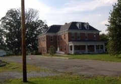 | Scott County Home | building | 2000 | 00000530 |
 | Scottsburg Courthouse Square Historic District | district | 2003 | 03000547 |
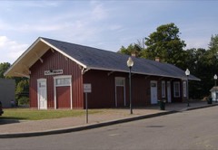 | Scottsburg Depot | building | 1991 | 91001162 |
Every wildfire the federal occurrence database records inside this county: 1 of them, burning about 60 acres. None started naturally and none was recorded as arson. Each settlement page carries the fires within five miles of it.
| Reported cause | Fires |
|---|---|
| Missing data/not specified/undetermined | 1 |
The five largest, by the area the report gives. None of them was recorded as arson.
| Date | Cause | Size | Reported by | Name on the report |
|---|---|---|---|---|
| 13 November 2010 | Missing data/not specified/undetermined | 60 acres | Big Oaks National Wildlife Refuge | LEXINGTON |
Every settlement page carries the fires within five miles of it - see the settlement index below.
The NOAA Storm Events Database holds 153 reports for this county, causing 2 deaths, 74 injuries and about $4,560,550 in recorded property damage. Each settlement page carries the reports that name it.
| Kind of event | Reports |
|---|---|
| Thunderstorm Wind | 88 |
| Hail | 27 |
| Flash Flood | 19 |
| Tornado | 16 |
| Flood | 3 |
The most serious of them, by death, then injury, then recorded damage. The accounts are quoted exactly as the forecast office filed them.
| When | Event | Place named | Harm | What the report says |
|---|---|---|---|---|
| April 1974 | Tornado (F4) | not stated | 1 killed, 15 hurt | no account filed |
| March 2012 | Tornado (EF4) | Nabb | 1 killed, $500,000 | After exiting Clark County as an EF-4, this one-third mile wide tornado tracked for only six tenths of a mile across extreme southeastern Scott County before entering Jefferson County between the eastern endpoint of County Road 550 South and State Route 362. ||Despite its limited distance in Scott County, however, the tornado proved to be deadly, taking the life of a 72 year old man who was in his frame home residence on State Route 362 east of Kelly Bottom Road, where two other wood frame homes were also severely damaged and 5 mobile homes completely destroyed. This damage proved consistent with 170 mph winds. |
| March 1986 | Tornado (F2) | not stated | 25 hurt, $2,500,000 | no account filed |
| March 2017 | Tornado (EF1) | Vienna | 10 hurt, $250,000 | The National Weather Service in conjunction with Scott County Emergency Management, determined an EF-1 Tornado touched down 4 miles south of Scottsburg, on Interstate 65 at approximately mile marker 25.5. After overturning a semi tractor-trailer on the Interstate, the tornado moved east-southeast, collapsed a wall on a large cinder block building, then destroyed two metal outbuildings and flipped an unanchored mobile home on a farmstead 1/4 mile east. It continued skipping east, uprooting and snapping trees and destroying an anchored mobile home on Underwood Road. Three residents were in the home at the time when it rolled over and disintegrated. They received minor injuries. The tornado then damaged an outbuilding and numerous more trees as it headed east toward Double or Nothing Road. Near the intersection of Double or Nothing Road and Radio Tower Road, it destroyed a large garage and pushed a double-wide manufactured home off its foundation. The tornado was embedded in a 1-2 mile wide area of 60 to 80 mph winds that extended further east for over 10 miles, and may have briefly touched down within this area as well.||Within the county, this tornado and two areas of straight-line wind resulted in approximately 23 minor injuries and the closure of seven roadways across the county. |
| April 1974 | Tornado (F5) | not stated | 10 hurt | no account filed |
| March 2017 | Thunderstorm Wind | Vienna | 8 hurt, $200,000 | A 1-2 mile swath of strong straight-line winds estimated at 60-80 mph moved across southern Scott County, downing trees and power lines and causing mainly minor roof damage. An EF-1 tornado was embedded within this area just east of Interstate 65. ||Between this area and another to the northeast of Austin, the Scott Emergency Manager reported that at least 15 homes were severely damaged, including those damaged by the tornado. Within the county, the winds and tornado resulted in approximately 23 minor injuries. There were numerous trees and power lines down which resulted in the closure of seven roadways across the county. |
| March 1961 | Tornado (F2) | not stated | 3 hurt, $250,000 | no account filed |
| March 2017 | Thunderstorm Wind | Austin | 3 hurt, $200,000 | A 1-2 mile swath of strong straight-line winds moved across northern Scott County and into western Jefferson County, damaging buildings and toppling trees. |Much of the roof of one home northeast of Austin was blown off, and several others sustained significant siding and roof damage. Local media reported a 5 inch diameter branch fell through a roof home. Numerous metal outbuildings were also damaged or destroyed. ||Between this area and another to the south of Scottsburg which included an EF-1 tornado, the Scott Emergency Manager reported that at least 15 homes were severely damaged by severe thunderstorm winds. Within the county, the winds and tornado resulted in approximately 23 minor injuries. There were numerous trees and power lines down which resulted in the closure of seven roadways across the county. |
| June 1990 | Tornado (F3) | not stated | $250,000 | no account filed |
| July 2015 | Flash Flood | Austin | $100,000 | A public report was received of high water in parts of Austin. An apartment building was partially flooded and rainfall amounts varied from 1 to locally 3 inches across the area. |
| January 2008 | Tornado (EF1) | Lexington | $70,000 | An EF1 tornado touched down just east of Lexington. It snapped and uprooted trees, destroyed a mobile home, and caused roof damage to a number of homes. |
| April 1993 | Thunderstorm Wind | not stated | $50,000 | The top of a silo was blown off near New Providence. |
| June 2018 | Thunderstorm Wind | Scottsburg | $40,000 | Two trees were down on homes in Scottsburg, Indiana. |
| August 1968 | Tornado (F2) | not stated | $25,000 | no account filed |
| January 1963 | Tornado (F2) | not stated | $25,000 | no account filed |
| June 2008 | Thunderstorm Wind | New Frankfort | $20,000 | County official reported barn roof blow off near Sunnyside Lane. Also reported corn silo damaged on County Road 256 near the county line. |
| May 1998 | Thunderstorm Wind | Austin | $20,000 | no account filed |
| July 2018 | Thunderstorm Wind | Scottsburg | $15,000 | Power lines blew down on Carla Lane in Scottsburg. |
| July 2018 | Thunderstorm Wind | Scottsburg | $15,000 | Power lines blew down on Gardner Street in Scottsburg. |
| July 2018 | Thunderstorm Wind | Scottsburg | $15,000 | Power lines blew down on Willow Shore Drive in Scottsburg. |
| October 2010 | Thunderstorm Wind | Scottsburg | $5,000 | A roof was blown off a barn on Double or Nothing Rd. |
| April 1985 | Tornado (F2) | not stated | $2,500 | no account filed |
| July 1996 | Thunderstorm Wind | Lexington | $2,000 | no account filed |
| May 1996 | Thunderstorm Wind | Countywide | $2,000 | no account filed |
| May 1996 | Thunderstorm Wind | Lexington | $2,000 | no account filed |
| July 2012 | Thunderstorm Wind | New Frankfort | $1,000 | A spotter's anemometer was destroyed by an estimated 60 mph wind gust. He was located just northwest of New Frankfort. |
| July 2012 | Thunderstorm Wind | Nabb | $1,000 | A spotter reported several shingles detaching from his roof within damaging wind gusts between 60 and 65 mph. |
| June 1994 | Thunderstorm Wind | not stated | $50 | Scott County Sheriff reported two downed trees in Leota. |
| April 2026 | Flash Flood | Scottsburg | - | There was high water at the intersection of State Road 56 and US 31. |
| March 2026 | Thunderstorm Wind | Scottsburg | - | The Scottsburg Water Department had its roof peeled back on the 700 block of West Lake Road West. |
| April 2025 | Tornado (EF0) | Leota | - | An EF2 tornado, with peak winds of 115 mph, tracked across a little over a 15-mile stretch of southern and eastern Washington County late Wednesday night. It likely dissipated over the heavily forested area along the Washington/Scott county border. |It was on the ground for 13 minutes and had a peak width of 600 yards.||The tornado ended in the woods northeast of the eastern end of Calloway Rd, or |somewhere near the Washington/Scott County border.. The survey also found some sporadic straight line wind damage along the storm's path into Scott County south of Scottsburg. |
| April 2025 | Thunderstorm Wind | Scottsburg | - | There was a roof torn off a building on South Lake Road. |
| March 2024 | Thunderstorm Wind | Lexington | - | A tree blew down on State Road 3. |
| May 2024 | Thunderstorm Wind | Scottsburg | - | There were multiple reports of tree damage from 2nd Street and Washington Street in Scottsburg. There was at least one power line down as well. |
| May 2024 | Thunderstorm Wind | Scottsburg | - | A tree was down at Lovers Lane and Prewitt Lane. |
| March 2024 | Thunderstorm Wind | New Frankfort | - | There was a tree down on State Road 203 near State Road 3. |
| July 2024 | Thunderstorm Wind | Vienna | - | Trees were downed on Double or Nothing Road near Indiana State Road 356. |
| July 2023 | Thunderstorm Wind | Vienna | - | Trees were blown down near the Clark County line. |
| August 2023 | Thunderstorm Wind | Scottsburg | - | A tree fell on a house in Scottsburg. |
| August 2023 | Thunderstorm Wind | Scottsburg | - | The survey team went across the west northwest side of Scottsburg over to Lake Iona. There was sporadic straight line wind damage of 60 mph. Trees were all facing towards the east northeast. |
| August 2023 | Thunderstorm Wind | Austin | - | Trees fell down over roads in Austin. |
| August 2023 | Thunderstorm Wind | Lexington | - | A tree fell down on a road. |
| July 2022 | Thunderstorm Wind | Scottsburg | - | There were multiple trees that were uprooted and power lines blown down in Scottsburg. |
| June 2022 | Thunderstorm Wind | Lexington | - | A tree was down in Lexington. |
| July 2021 | Flash Flood | New Frankfort | - | Multiple roads flooded east of Scottsburg. |
| October 2021 | Tornado (EF0) | Lexington | - | The National Weather Service in Louisville conducted a storm damage survey across Scott county, Indiana. The survey team found damage consistent with 80 mph winds in Lexington, Indiana. The tornado began at the Lexington cemetery and continued all the way to the Lexington fire and rescue. The tornado uprooted, twisted, and snapped numerous trees at the cemetery with the trees falling in a northerly, northeasterly, southeasterly, and southwesterly direction. This is where the widest part of the tornado was observed with approximately a 75 yard width.||Several trees were snapped along Charlestown Road with more significant damage along South Stuard Street. A couple of homes had shingle damage and loose items such as gas cans and garden decorations that were thrown 50 yards.||Power crews were working feverishly to restore power all along South Mulberry Street, where trees were thrown in multiple directions and across power lines. Power company workers said that several of the power poles were snapped or cracked.||The tornado continued along South Cherry St. with a very narrow path of only 40 to 50 yards, and lifted around the Lexington Fire and Rescue. Several witnesses told us that they heard windows being opened up and a distinct roar in the air. |
| July 2020 | Thunderstorm Wind | Nabb | - | Trees were reported down along State Road 3. |
| March 2019 | Thunderstorm Wind | New Frankfort | - | A tree was reported down at Hardy Lake in Scott County, Indiana. |
| June 2019 | Thunderstorm Wind | Scottsburg | - | Trees were reported down throughout Scott County, Indiana. |
| June 2018 | Thunderstorm Wind | New Frankfort | - | Trees were reported down along State Road 56. |
| June 2018 | Flash Flood | Scottsburg | - | The emergency manager of Scott County, Indiana reported that the main intersection in Scottsburg was flooded. |
| February 2018 | Flash Flood | Scottsburg | - | Public reported flash flooding on US 31N, north of Indiana 56 and east of I-65. |
| May 2018 | Thunderstorm Wind | Scottsburg | - | There was a tree down on one of the exit ramps from Interstate 65 to Scottsburg, Indiana. |
| May 2018 | Thunderstorm Wind | Scottsburg | - | There was a tree down at Scottsburg High School. |
| July 2018 | Thunderstorm Wind | Scottsburg | - | A tree blew down on Madison Street. |
| July 2018 | Thunderstorm Wind | Blocher | - | A large tree was reported down on State Road 56 near Blocher. |
| July 2017 | Thunderstorm Wind | Austin | - | The Scott County Emergency Manager reported several downed trees blocking Harrod Road. |
| April 2016 | Thunderstorm Wind | Austin | - | Scott County law enforcement reported trees and power lines down just east of Austin. |
| June 2015 | Hail | Austin | - | A broadcast meteorologist relayed a report of nickel size hail. |
| June 2015 | Thunderstorm Wind | Austin | - | A law enforcement official reported trees down in the city of Austin. |
The Survey's mineral resources record lists 5 workings inside this county. 1 still produces and 4 are closed or unrecorded. Each settlement page carries the workings within five miles of it.
| Commodity | Workings |
|---|---|
| Fluorine-Fluorite | 2 |
| Iron | 2 |
| Stone, Crushed/Broken | 1 |
The least common of them first, because a county's hundredth gravel pit says nothing its first ten did not.
| Where | Site | Commodity | Status | Recorded |
|---|---|---|---|---|
| Hardy Quarry | Stone, Crushed/Broken | Producer | ||
| Fluorite Occurrence Number 1 | Fluorine-Fluorite | Occurrence | ||
| Fluorite Occurrence Number 1 | Fluorine-Fluorite | Occurrence | ||
| Unnamed Prospect | Iron | Occurrence | ||
| Unnamed Prospect | Iron | Occurrence |
Named settlements recorded in the Geographic Names Information System, each with the topographic sheets covering it. Villages, hamlets and abandoned places alike. Each is shown with the nearest named watercourse or landform and the survey quadrangle it falls on.
Vienna township · 47170 · On Scottsburg Drain · Scottsburg quadrangle
12 sheets, 1947 to 1990