 Block
From the record
9 National Register listings published here.
Sources: the National Register database, National Park Service
49 topographic sheets cover 23 settlements here, and 9 properties are on the National Register of Historic Places.
9 National Register listings published here.
Sources: the National Register database, National Park Service
Every property in this county listed on the National Register of Historic Places, with the year it was listed and the federal nomination document.
| Photograph | Property | Type | Listed | Reference |
|---|---|---|---|---|
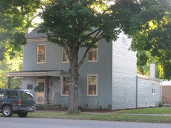 | Edward and George Cary Eggleston House | building | 1973 | 73000046 |
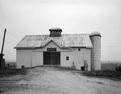 | Merit-Tandy Farmstead | building | 1977 | 77000021 |
 | Old Hoosier Theatre | building | 1982 | 82000077 |
 | Benjamin Schenck Mansion | building | 2002 | 02001174 |
 | Switzerland County Courthouse | building | 2009 | 09000435 |
 | Thiebaud Farmstead | building | 2004 | 04000629 |
 | Venoge Farmstead | building | 1997 | 96001539 |
| Vevay Historic District | district | 2019 | 100004722 | |
 | Thomas T. Wright House | building | 1980 | 80000066 |
The NOAA Storm Events Database holds 183 reports for this county, causing 2 deaths, 41 injuries and about $21,514,550 in recorded property damage. Each settlement page carries the reports that name it.
| Kind of event | Reports |
|---|---|
| Thunderstorm Wind | 99 |
| Flash Flood | 32 |
| Hail | 31 |
| Flood | 11 |
| Tornado | 10 |
The most serious of them, by death, then injury, then recorded damage. The accounts are quoted exactly as the forecast office filed them.
| When | Event | Place named | Harm | What the report says |
|---|---|---|---|---|
| June 2016 | Thunderstorm Wind | Fairview | 1 killed, $25,000 | An 11 year old girl was fatally injured when a healthy tree was downed and fell on a cabin at Camp Livingston. The tree was possibly struck by lightning. |
| December 2021 | Flood | Markland | 1 killed, $20,000 | A vehicle was swept away while driving through a low a water crossing along Bud Ballard Road, resulting in one fatality. F55VE. |
| April 1974 | Tornado (F4) | not stated | 40 hurt | no account filed |
| November 1992 | Tornado (F4) | not stated | 1 hurt, $2,500,000 | no account filed |
| September 2022 | Flash Flood | Avonburg | $18,000,000 | Eight to 10 inches of rain over a few hour period caused significant flash flooding over portions of western Switzerland County. Numerous creeks and streams were out of their banks. The hardest hit areas were in the vicinity of Bennington and along Indian Creek, where several county bridges were heavily damaged and a couple of bridges were washed out. Significant damage occurred to numerous homes along Indian Creek with trees also downed by the flowing water and roadways along the creek washed out in places. |
| March 2024 | Tornado (EF1) | Vevay Robinson Arpt | $250,000 | The tornado first developed in Jefferson County, Indiana, at 1258EST, on the north side of Hanover. The tornado moved east across the Ohio River into Trimble County, Kentucky, and then into Carroll County, Kentucky, before crossing the Ohio River again and moving back into Jefferson County, Indiana. The tornado continued east and entered Switzerland County at 1318EST. ||While in Switzerland County, the tornado damaged three barns along Green Valley Road. All the barns sustained significant roof panel damage. Some trees were also uprooted and numerous other trees were topped and snapped. The tornado continued east and caused widespread tree damage on the north hillside along State Route 56. The tornado did extensive power pole and powerline damage, along with tree damage, near the intersection of Patton Hollow Road and State Route 56. Wind speeds were estimated to be 90 mph here with a tornado width of 150 yards. From here, the tornado moved out of Switzerland County at 1322EST as it crossed the Ohio River for a third time, going back into Carroll County, Kentucky. Once in Carroll County, the tornado quickly weakened and ended at 1324EST, 2 miles east of Carrollton. |
| April 2011 | Tornado (EF1) | Antioch | $90,000 | The tornado touched down near State Route 250 and Antioch Road. The tornado traveled to the northeast across Devers Road and toward North Branch Road before lifting near North Branch Road. Three barns were destroyed and two roofs were blown off of residences due to the tornado. |
| March 1997 | Thunderstorm Wind | Vevay | $50,000 | no account filed |
| August 2022 | Flash Flood | Quercus Grove | $30,000 | A portion of Lower Grants Creek Road was washed out near Oatman Hill Road. |
| April 2011 | Thunderstorm Wind | Patriot | $30,000 | A mobile home collapsed due to damaging thunderstorm winds. |
| March 2017 | Thunderstorm Wind | Florence | $25,000 | A car was overturned and there was significant structural damage in the 14000 block of Bethel Ridge Road. The damage was consistent with winds in the 65 to 85 mph range. |
| May 2022 | Thunderstorm Wind | Florence | $20,000 | About 20 trees were downed along State Route 156, east of Florence. |
| April 2005 | Hail | Vevay | $20,000 | no account filed |
| April 1996 | Thunderstorm Wind | Moorefield | $20,000 | no account filed |
| April 2019 | Thunderstorm Wind | Patriot | $15,000 | Damage to several trees and buildings was reported. |
| April 2019 | Thunderstorm Wind | Patriot | $15,000 | A building sustained uplift of the roof deck and loss of roof covering material. |
| July 2008 | Thunderstorm Wind | Center Square | $15,000 | A barn and several trees were knocked down along Florence Hill Road. One inch hail occurred in Center Square. |
| January 2005 | Flash Flood | Countywide | $15,000 | Several roads were washed out by the heavy rains. |
| July 2023 | Thunderstorm Wind | Florence | $10,000 | A few trees were downed and a roof was blown off of a mobile home. |
| April 2019 | Thunderstorm Wind | Patriot | $10,000 | Structures lost some shingles and a building had an uplift of a metal roof covering. |
| April 2017 | Flash Flood | Vevay | $10,000 | A road was closed and water was reported in the lower levels of homes in Vevay. |
| August 2016 | Flood | Braytown | $10,000 | A mudslide closed State Route 56 from Green Valley Road to Spring Branch Road. |
| December 2006 | Thunderstorm Wind | Pleasant | $10,000 | Trees were downed across the county. |
| July 2001 | Thunderstorm Wind | Countywide | $10,000 | Numerous trees were knocked down across the county and a barn roof was blown off in Patriot. |
| January 2000 | Flash Flood | East Enterprise | $10,000 | Heavy rainfall caused Log Lick road to be closed. |
| November 2000 | Thunderstorm Wind | Patriot | $10,000 | Thunderstorm winds knocked down trees and blew a trampoline into a pickup truck. |
| August 2000 | Thunderstorm Wind | Countywide | $10,000 | Numerous trees and power lines downed. |
| August 2000 | Thunderstorm Wind | Countywide | $10,000 | Numerous trees and power lines downed. |
| March 1997 | Thunderstorm Wind | Bennington | $10,000 | no account filed |
| August 2024 | Thunderstorm Wind | Vevay | $8,000 | Several trees were downed on the east side of Vevay, primarily along Ohio Street and East Seminary Street. |
| January 2006 | Thunderstorm Wind | East Enterprise | $8,000 | Several trees and powerlines were downed. One home also sustained roof damage. |
| June 2006 | Thunderstorm Wind | Countywide | $8,000 | Several large tree limbs were knocked down. |
| May 2004 | Thunderstorm Wind | Countywide | $8,000 | Numerous trees were downed. |
| July 2003 | Thunderstorm Wind | Countywide | $8,000 | Trees were knocked down, including one that fell on a house in Vevay, producing minor structural damage. |
| March 2006 | Thunderstorm Wind | East Enterprise | $7,000 | An RV was flipped over on its side. A barn was destroyed along State Route 250. |
| April 2020 | Thunderstorm Wind | Florence | $6,000 | A garage sustained roof damage on Bethel Ridge Road. Also, a few small trees were knocked down. |
| March 2025 | Thunderstorm Wind | Jacksonville | $5,000 | Several trees and power poles were downed along Fairview Road. |
| July 2023 | Thunderstorm Wind | Florence | $5,000 | Several trees were downed. |
| July 2018 | Thunderstorm Wind | Center Square | $5,000 | Numerous trees were downed across western portions of Switzerland County. |
| July 2014 | Flash Flood | Jacksonville | $5,000 | Four vehicles were washed away at a residence due to flash flooding from heavy rain. Twelve roads were also closed across the county due to high water. |
| April 2006 | Thunderstorm Wind | Vevay | $5,000 | Trees and power lines were downed. |
| July 2003 | Thunderstorm Wind | Countywide | $5,000 | Several large tree limbs were knocked down. |
| May 2001 | Flash Flood | East Enterprise | $5,000 | Flooding occurred across State Route 250 due to heavy rainfall. |
| July 2001 | Thunderstorm Wind | Countywide | $5,000 | Trees knocked down. |
| February 2000 | Flash Flood | Florence | $5,000 | Water flooded across State Route 156 near the Markland Dam. |
| August 2000 | Thunderstorm Wind | Vevay | $5,000 | Trees down around Vevay and near Markland Dam. |
| August 2000 | Flash Flood | Countywide | $5,000 | Heavy rainfall caused roads across the county to be flooded. |
| November 1998 | Thunderstorm Wind | Countywide | $5,000 | Numerous trees and power poles down. |
| April 1994 | Thunderstorm Wind | not stated | $5,000 | Trees and power lines were blown down along Highway 129 at Morefield. |
| August 1993 | Thunderstorm Wind | Pleasant | $5,000 | Power lines and trees were downed. |
| July 2008 | Thunderstorm Wind | Vevay | $5,000 | no account filed |
| August 2007 | Hail | Moorefield | $5,000 | no account filed |
| January 1997 | Thunderstorm Wind | Vevay | $5,000 | no account filed |
| May 1996 | Flash Flood | Countywide | $5,000 | no account filed |
| April 1996 | Flash Flood | Vevay | $5,000 | no account filed |
| November 1996 | Thunderstorm Wind | Countywide | $5,000 | no account filed |
| May 2022 | Thunderstorm Wind | Pleasant | $4,000 | A tree was downed onto power lines. |
| July 2014 | Thunderstorm Wind | Vevay | $4,000 | Several trees were reported down across the county due to thunderstorm winds. |
| June 2005 | Thunderstorm Wind | East Enterprise | $4,000 | Four trees were downed. |
| July 1995 | Thunderstorm Wind | Pleasant | $4,000 | Trees and power lines were downed. |
The Survey's mineral resources record lists 3 workings inside this county. All of them still produce. Each settlement page carries the workings within five miles of it.
| Commodity | Workings |
|---|---|
| Sand and Gravel, Construction | 2 |
| Stone, Crushed/Broken | 1 |
The least common of them first, because a county's hundredth gravel pit says nothing its first ten did not.
| Where | Site | Commodity | Status | Recorded |
|---|---|---|---|---|
| Tri-County Quarry | Stone, Crushed/Broken | Producer | ||
| Patriot Aggregate Plant | Sand and Gravel, Construction | Producer | ||
| Switzerland Co. Hwy. Dept. | Sand and Gravel, Construction | Producer |
Named settlements recorded in the Geographic Names Information System, each with the topographic sheets covering it. Villages, hamlets and abandoned places alike. Each is shown with the nearest named watercourse or landform and the survey quadrangle it falls on.
Pleasant township · 47043 · Near Chapel Ridge · Cross Plains quadrangle
9 sheets, 1956 to 1990
Cotton township · 47043 · Near McCreary Ridge · Florence quadrangle
11 sheets, 1943 to 1986
Cotton township · 47011 · Near Drakes Ridge · Vevay North quadrangle
12 sheets, 1943 to 1990
Posey township · 47038 · Near Searcy Ridge · Patriot quadrangle
12 sheets, 1943 to 1986
Pleasant township · 47043 · Near Parks Ridge · Bennington quadrangle
10 sheets, 1956 to 1990
Jefferson township · 47043 · On Upper Indian Creek · Vevay North quadrangle
12 sheets, 1943 to 1990
Posey township · 47040 · Near Hominy Ridge · Florence quadrangle
11 sheets, 1943 to 1986
Posey township · 47038 · Near Searcy Ridge · Patriot quadrangle
12 sheets, 1943 to 1986