BlockBefore
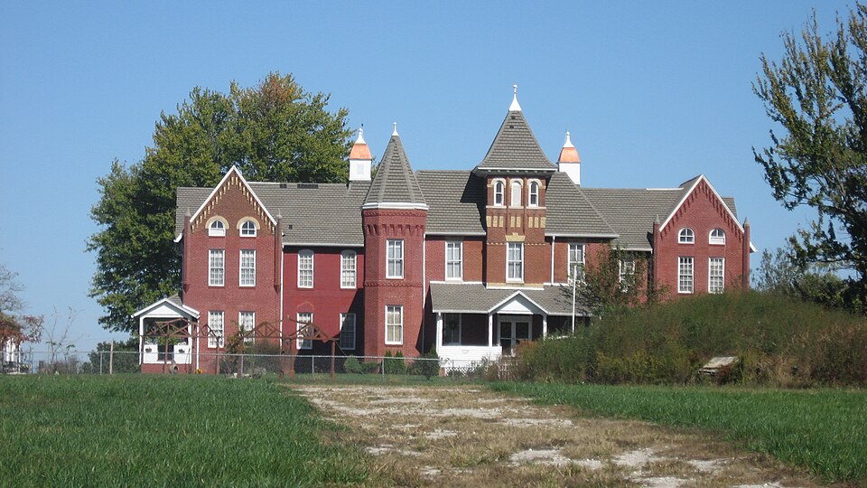
Photograph of Sullivan County Poor Home
Photograph by Nyttend, Public domain. Via Wikimedia Commons.

Sullivan County Poor Home

Listed on the National Register of Historic Places in 2000.

From the record

“Sullivan County Poor Home, also known as Lakeview Home, is a historic poorhouse located in Hamilton Township, Sullivan County, Indiana, United States. It was designed by the architecture firm Wing & Mahurin and built in 1896-1897.”

Wikipedia article Sullivan County Poor Home, CC BY-SA 4.0.

One of 9 National Register listings published here for Sullivan County · listed in 2000 · category: Building.

Sources: the Wikipedia article · the case file at the National Archives · the National Register database, National Park Service


The listing

  • What is counted as historic. The nomination lists 2 buildingss as contributing to the listing.
  • Address. 1447 Cty Rd. 75 N, Sullivan, 47882
  • When was it listed? March 2000
  • Category. building
  • Township. Hamilton township
  • National Register reference number. 00000207 - the number the National Park Service assigned this property when it was listed, and the key its nomination file is catalogued under at the National Archives.

Storms near this property

54 since 1996

Regional context, not property-specific evidence. The National Weather Service names Sullivan, the town this property stands in, in 54 storm reports between 1996 and 2026: 32 thunderstorm wind, 11 flash flood, 10 hail, 1 tornado. No death or injury is recorded in these reports. Each account below is quoted exactly as the forecast office filed it, from the NOAA Storm Events Database, and each date opens the federal record of that event.

WhenEvent Place namedHarm What the report says
June 2008Flash FloodSullivan$30,000Numerous cars were helped out of high water on various low spots on the roadways due to heavy rainfall that caused flash flooding.
April 2011Tornado (EF0)Sullivan$20,500An EF0 tornado briefly occurred near 621 E. Silver Street in Sullivan, Indiana. Damage was done to a home at this location. There was damage to a roof, one bathroom window was blown out, and a trampoline was blown over. Roof debris was spread out over the owner's lawn, with some shingles blown into a nearby tree and one large piece of ply wood from the roof was blown over the neighbor's house, up into a tree approximately 40 feet high.
April 2020Thunderstorm WindSullivan$20,000Several large tree limbs and trees snapped due to thunderstorm wind gusts across the area with a concentrated area within the town of Sullivan. Numerous power outages reported as well.
April 2011Flash FloodSullivan$20,000Numerous roads were reported to be flooded due to thunderstorm heavy rainfall. Some cars were also reported to be stranded.
July 2023Flash FloodSullivan$15,000Several roads with deep standing water or water flowing through town. A car was stalled on one of the roads.
May 2018Thunderstorm WindSullivan$15,000There were numerous reports of several trees downed and power out across the city due to damaging thunderstorm wind gusts.
July 2016Thunderstorm WindSullivan$15,000A barn was destroyed in this location due to damaging thunderstorm wind gusts.
May 2008Flash FloodSullivan$15,000Heavy rain caused numerous county roads in central Sullivan County to be flooded. Streets in the town of Sullivan were flooded in addition to cars being stranded in the flood waters.
March 2024Thunderstorm WindSullivan$10,000Numerous tree limbs of unknown size downed by thunderstorm wind gusts across town.
May 2002Thunderstorm WindSullivan$10,000Semi blown over along U.S. 41
June 2009Thunderstorm WindSullivan$8,000The Sullivan Daily Times reported numerous trees and power lines down in the area due to thunderstorm wind gust. The Sullivan City Fire Department responded to a power line on fire near West Washington Street and County Road 200W.
April 2020Thunderstorm WindSullivan$5,000Spotter reported several large tree limbs snapped near his location due to thunderstorm wind gusts with live power lines on the road.
August 2019Thunderstorm WindSullivan$5,000Spotter reported 3 utility poles snapped at the ground and held up by the wires. Relayed via amateur radio and time estimated from radar.
May 2018Thunderstorm WindSullivan$5,000Trees were downed in City Park due to damaging thunderstorm wind gusts. This report was relayed via social media.
June 2008Flash FloodSullivan$5,000Roadways were covered and previous flooding conditions were exacerbated due to heavy rainfall that caused renewed flash flooding.
February 2026Thunderstorm WindSullivan$4,000Thunderstorm wind gusts downed several large tree limbs across town.
September 2014Thunderstorm WindSullivan$2,000A tree was downed in Sullivan and another one was downed five miles south of Sullivan due to damaging thunderstorm wind gusts.
June 2008Thunderstorm WindSullivan$2,000Power lines were down due to damaging thunderstorm winds.
August 2007Thunderstorm WindSullivan$2,000A trained spotter reported tree limbs, power lines, and signs down due to damaging thunderstorm winds.
August 2006Thunderstorm WindSullivan$2,000Fallen tree limbs caused power outages in Sullivan.
June 2016Thunderstorm WindSullivan$1,500A tree and some limbs were downed in this location due to damaging thunderstorm wind gusts.
December 2013Flash FloodSullivan$1,000Severe flooding was reported on secondary roads in low lying areas across the county.
April 2011Flash FloodSullivan$1,000Several areas along State Highway 54 had water flowing over it due to thunderstorm heavy rainfall.
May 2025HailSullivan-Numerous other hail reports ranging in size from 1-2 inches.
April 2024Thunderstorm WindSullivan-A 60 mph thunderstorm wind gust was measured at this location.
April 2018Thunderstorm WindSullivan-A thunderstorm wind gust of 60 mph or more was estimated in this location.
July 2010Thunderstorm WindSullivan-A thunderstorm wind gust of 60 mph was estimated on Washington Street in Sullivan.
April 2007Thunderstorm WindSullivan-Damaging thunderstorm winds caused a tree to fall.
April 2007Thunderstorm WindSullivan-Thunderstorm winds caused a tree to fall in Sullivan County.
April 2007Thunderstorm WindSullivan-Damaging thunderstorm winds caused a few trees to fall in Sullivan.
June 2006Thunderstorm WindSullivan-Large tree limbs broken throughout town.
January 2005Flash FloodSullivan-A levee failed along the Wabash River.
November 2005Thunderstorm WindSullivan-Trees were downed.
July 2004Thunderstorm WindSullivan-Trees were knocked down.
August 2004Flash FloodSullivan-High water was reported over several roads in Sullivan.
March 2025HailSullivan-no account filed
May 2025HailSullivan-no account filed
June 2023HailSullivan-no account filed
June 2010HailSullivan-no account filed
February 2006HailSullivan-no account filed
April 2006Thunderstorm WindSullivan-no account filed
May 2004Flash FloodSullivan-no account filed
May 2004HailSullivan-no account filed
July 2002Thunderstorm WindSullivan-no account filed
April 2001HailSullivan-no account filed
July 2001Flash FloodSullivan-no account filed
April 2000HailSullivan-no account filed
May 2000Thunderstorm WindSullivan-no account filed
September 2000Thunderstorm WindSullivan-no account filed
June 1999Thunderstorm WindSullivan-no account filed
March 1997Thunderstorm WindSullivan-no account filed
July 1996Thunderstorm WindSullivan-no account filed

Every storm recorded in Sullivan County

Map coverage status

No historic map-sheet match is published for this property yet. That does not mean no map exists. This record needs a coordinate-quality review before it can be joined to a sheet boundary. Browse the county's mapped places while that work is pending.

Listed places nearby

5 within 8 miles

Other National Register properties close enough to walk or drive between, ordered by distance from this one. Both positions come from the same geocoding pass that matched these properties to their map sheets.

Photograph PropertyDistance Listed
Sullivan Courthouse Square Historic District1.3 miles2018
Sullivan County Courthouse1.4 miles2008
Sherman Building1.4 miles1986
Center Ridge Cemetery2.1 miles2018
Shelburn Interurban Depot-THI&E Interurban Depot5.6 miles2015

Sources for this property

National Archives recordThe nomination case file for reference 00000207 in Record Group 79.
Wikipedia articleCommunity-written account of this property, licensed CC BY-SA.
Sullivan CountyAll 9 listed properties in this county.

Provenance

  • Listing record. National Park Service National Register of Historic Places, listed-properties dataset, current to 2026-05-22.
  • Map join. Address geocoded through the United States Census geocoder, then tested against the published boundary of every sheet in the USGS Historical Topographic Map Collection.
  • How this page is made. Listing fields come from federal records; map-sheet coverage is a labelled coordinate-to-boundary calculation, not a source-field claim.
  • Storms. NOAA National Centers for Environmental Information, Storm Events Database https://www.ncei.noaa.gov/stormevents/ A work of the United States government, no copyright under 17 U.S.C. 105. Narratives are quoted verbatim from the National Weather Service report and are not edited or summarised.