 Block
From the record
One of 34 National Register listings published here for Marshall County · listed in 2017 · category: District.
Sources: the National Register database, National Park Service
Listed on the National Register of Historic Places in 2017.
One of 34 National Register listings published here for Marshall County · listed in 2017 · category: District.
Sources: the National Register database, National Park Service
Regional context, not property-specific evidence. The federal mineral resources record lists 2 workings within 5 miles of Argos Northside Historic District,: 1 past producer, 1 producer. 1 still produces. What was taken out: Limestone, General, Sand and Gravel, Construction. Distance is straight-line from the map coordinates, so a quarry counted here may appear on a neighbouring settlement's page as well.
| Where | Site | Commodity | Status | Recorded |
|---|---|---|---|---|
| Eddy Lake Marl Pit | Limestone, General | Past Producer | ||
| White Pit | Sand and Gravel, Construction | Producer |
Regional context, not property-specific evidence. The National Weather Service names Argos, the town this property stands in, in 18 storm reports between 1999 and 2024: 13 thunderstorm wind, 4 hail, 1 tornado. No death or injury is recorded in these reports. Each account below is quoted exactly as the forecast office filed it, from the NOAA Storm Events Database, and each date opens the federal record of that event.
| When | Event | Place named | Harm | What the report says |
|---|---|---|---|---|
| August 2007 | Tornado (EF1) | Argos | $500,000 | The initial touchdown of the tornado was located a large grove of trees along Maple Rd. west of Argos and proceeded rapidly southeast to the southeast side of Argos. The tornado skipped along its track, snapping and uprooting numerous trees, downing power poles and lines and damaging some structures. Two businesses on the south side of Argos, near the intersection of US 31 and State Rd 10 suffered moderate damage. The roof of the Topp Industries plant suffered damage. A McDonalds/BP Station suffered metal siding and roofing damage along with the removal of a few gas pumps. A stationary police cruiser was spun by a combination of the strong winds and a sign post striking the car. Neither the officer, nor anyone else in the path of the tornado was injured. The tornado lifted southeast of this point. Exact damage figures were not available, but are estimated to be at least $500,000. |
| July 2007 | Thunderstorm Wind | Argos | $50,000 | A 150 year old barn was destroyed, as well as a 200 foot section of roof of adjacent work shop being ripped off. Trees were also reported down around Argos. Damage is estimated around $50,000. |
| August 2000 | Thunderstorm Wind | Argos | $10,000 | Large shed destroyed. |
| April 1999 | Thunderstorm Wind | Argos | $3,000 | Conservation officer reported to county sheriff that trees and power lines were down. |
| August 2022 | Thunderstorm Wind | Argos | $2,000 | A tree branch about 2 feet in diameter was snapped. |
| July 2024 | Thunderstorm Wind | Argos | $1,000 | Large limbs down on Kenilworth Rd in Argos. |
| June 2023 | Hail | Argos | $1,000 | no account filed |
| March 2022 | Thunderstorm Wind | Argos | - | A INDOT mesonet site northwest of Argos recorded a 62 mph wind gust. |
| June 2021 | Hail | Argos | - | Public report relayed by WNDU through Twitter. |
| May 2019 | Thunderstorm Wind | Argos | - | The public reported numerous trees down in the area. A large wooded playset was tossed several yards. |
| May 2019 | Thunderstorm Wind | Argos | - | The public reported a six to twelve inch diameter tree limb was blown down onto a home. |
| June 2017 | Thunderstorm Wind | Argos | - | Law enforcement officials reported a large tree was blown down. DOWN. |
| May 2015 | Thunderstorm Wind | Argos | - | The public reported a tree snapped at the base and fell onto a power line. |
| November 2013 | Thunderstorm Wind | Argos | - | Emergency management officials reported trees was blown down across Yearick and 1st Streets. |
| May 2007 | Thunderstorm Wind | Argos | - | Numerous trees, tree limbs, power lines and poles were reported down across the county, including Argos, Plymouth, and Bourbon. No reports of significant structure damage were received. |
| May 2005 | Thunderstorm Wind | Argos | - | Tree blown over. |
| June 2023 | Hail | Argos | - | no account filed |
| May 2000 | Hail | Argos | - | no account filed |
No historic map-sheet match is published for this property yet. That does not mean no map exists. This record needs a coordinate-quality review before it can be joined to a sheet boundary. Browse the county's mapped places while that work is pending.
Other National Register properties close enough to walk or drive between, ordered by distance from this one. Both positions come from the same geocoding pass that matched these properties to their map sheets.
| Photograph | Property | Distance | Listed |
|---|---|---|---|
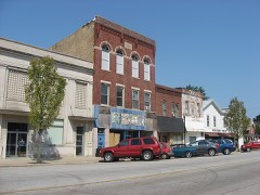 | Argos Downtown Historic District | 0.3 miles | 2001 |
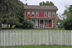 | Lewis and Sarah Boggs House | 2.5 miles | 2012 |
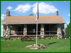 | Argos Izaak Walton League Historic District | 2.8 miles | 2011 |
| Sults-Quivey-Hartman Polygonal Barn and Farm | 4.8 miles | 2019 | |
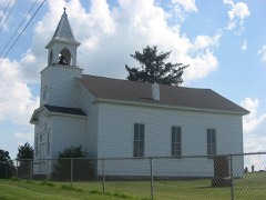 | Jacoby Church and Cemetery | 4.8 miles | 2007 |
 | Marshall County Infirmary | 6.1 miles | 2000 |
| National Archives record | The nomination case file for reference 100001613 in Record Group 79. |
| Marshall County | All 34 listed properties in this county. |