 Block
From the record
One of 10 National Register listings published here for LaGrange County · listed in 2022 · category: Building.
Sources: the National Register database, National Park Service
Listed on the National Register of Historic Places in 2022.
One of 10 National Register listings published here for LaGrange County · listed in 2022 · category: Building.
Sources: the National Register database, National Park Service
Regional context, not property-specific evidence. The federal mineral resources record lists 1 working within 5 miles of Bloomfield Township Graded School: 1 producer. All of them still produce. What was taken out: Stone. Distance is straight-line from the map coordinates, so a quarry counted here may appear on a neighbouring settlement's page as well.
| Where | Site | Commodity | Status | Recorded |
|---|---|---|---|---|
| Lagrange Co. Hwy. Dept. | Stone | Producer |
Regional context, not property-specific evidence. The National Weather Service names LaGrange, the town this property stands in, in 48 storm reports between 1994 and 2024: 34 thunderstorm wind, 12 hail, 2 tornado. The reports record 1 injury. Each account below is quoted exactly as the forecast office filed it, from the NOAA Storm Events Database, and each date opens the federal record of that event.
| When | Event | Place named | Harm | What the report says |
|---|---|---|---|---|
| May 1997 | Tornado (F0) | Lagrange | 1 hurt, $1,500,000 | no account filed |
| June 2010 | Thunderstorm Wind | Lagrange | $60,000 | Numerous trees downed with some on cars. Power lines down across town and a barn was destroyed. |
| November 1998 | Thunderstorm Wind | Lagrange | $50,000 | LAKELAND HIGH SCHOOL HAD ONE AUDITORIUM WALL BLOWN IN BY THE STRONG WINDS. |
| June 2024 | Thunderstorm Wind | Lagrange | $20,000 | A few trees and large limbs down along with downed power lines. About 350 to 400 customers without power. |
| June 2007 | Thunderstorm Wind | Lagrange | $15,000 | Trees were reported down in and around the city of Lagrange. |
| June 2005 | Thunderstorm Wind | Lagrange | $15,000 | Trees were reported down in Lagrange, with one tree falling onto a parked car. A car also struck a buggy somewhere in the county as a result of heavy rain. No further details were available. |
| July 2004 | Thunderstorm Wind | Lagrange | $15,000 | Several large trees were knocked down around Oliver Lake. An 18 inch diameter apple tree was uprooted on the west side of the lake. An 20 inch diameter tree was knocked down onto a pontoon and lift and a 31 inch diameter tree was snapped at the base, with an aluminum flag pole being snapped off. Damage amount estimated. |
| August 2007 | Thunderstorm Wind | Lagrange | $10,000 | Several trees limbs and power lines were blown down in the city of Lagrange at the intersection of Mountain and Michigan streets. |
| May 2000 | Thunderstorm Wind | Lagrange | $10,000 | Barn destroyed. Trees and power lines down. |
| July 2023 | Thunderstorm Wind | Lagrange | $5,000 | Emergency Manager reports multiple trees down. |
| August 2022 | Thunderstorm Wind | Lagrange | - | A trained spotter estimated a 50 knot wind gust. |
| June 2020 | Thunderstorm Wind | Lagrange | - | Numerous limbs and trees down. |
| May 2018 | Thunderstorm Wind | Lagrange | - | Law enforcement officials reported a tree was blown down in the area of County Road 1800 N on 075 E. |
| July 2016 | Thunderstorm Wind | Lagrange | - | Local media reported a six inch diameter maple tree trunk was blown down. There was some indications of rot. |
| July 2014 | Thunderstorm Wind | Lagrange | - | Emergency management officials reported widespread tree damage in town. There was a partial roof and wall collapse at Parkside School. |
| June 2014 | Thunderstorm Wind | Lagrange | - | Emergency management officials reported several large trees limbs were down across the county. |
| July 2014 | Tornado (EF1) | Lagrange | - | A NWS survey found damage consistent with a EF-1 tornado in a larger area of straight line wind damage. The tornado touched down just west of LaGrange on US-20 East of County Road 100 West, where tree limb damage was observed. The tornado tracked east towards LaGrange, uprooting and snapping trees as it entered the town south of the local hospital. Numerous trees were uprooted and snapped just west of South County Road 00 East between US-20 and Grant Street. The tornado produced minor structural damage to homes along Grant Street before lifting just west of South Mountain Street. Maximum winds were estimated at 95 mph. |
| July 2012 | Thunderstorm Wind | Lagrange | - | Local officials reported a power line down at the intersection of County Roads 1290 North and 300 East. |
| July 2012 | Thunderstorm Wind | Lagrange | - | Law enforcement officials reported several trees down with power outages throughout the county. |
| July 2012 | Thunderstorm Wind | Lagrange | - | A report of a tree being blown down, landing on a SUV, was found posted on Facebook. |
| September 2011 | Thunderstorm Wind | Lagrange | - | Law enforcement officials reported trees and power lines down throughout the county. |
| September 2011 | Thunderstorm Wind | Lagrange | - | A local newspaper reported a large tree limb, roughly 18 inches in diameter, was blown down by the strong winds, landing on the north side of the county courthouse. No damage occurred to the building from the tree limb. |
| June 2010 | Thunderstorm Wind | Lagrange | - | Emergency management officials reported numerous trees and power lines down, along with a few power poles snapped. A few trees were reported to have fallen on cars and houses, but no specific damage or details were provided. |
| July 2005 | Thunderstorm Wind | Lagrange | - | A large tree was reported blown down. |
| July 2005 | Thunderstorm Wind | Lagrange | - | Several large trees were blown down 8 miles northeast of Lagrange. As the storm continued east, a vehicle was blown off the Indiana Toll Road at mile marker 132, near the Lagrange and Steuben county line. No injuries were reported. |
| May 2004 | Hail | Lagrange | - | Law enforcement reported softball size hail in Howe, northwest of the city of La Grange. |
| May 2004 | Thunderstorm Wind | Lagrange | - | Law enforcement reported trees down northeast of the city of La Grange. |
| August 2003 | Thunderstorm Wind | Lagrange | - | Trees were reported down. |
| August 2001 | Thunderstorm Wind | Lagrange | - | Trees and power lines down. |
| May 2000 | Thunderstorm Wind | Lagrange | - | Large limbs down. |
| September 2000 | Thunderstorm Wind | Lagrange | - | Trees down. |
| July 1998 | Thunderstorm Wind | Lagrange | - | NUMEROUS TREES AND POWER LINES DOWN. |
| October 1998 | Thunderstorm Wind | Lagrange | - | SEVERAL TREES AND POWER LINES WERE BLOWN DOWN IN THE TOWN. |
| June 2019 | Hail | Lagrange | - | no account filed |
| June 2019 | Hail | Lagrange | - | no account filed |
| September 2014 | Hail | Lagrange | - | no account filed |
| July 2012 | Hail | Lagrange | - | no account filed |
| July 2011 | Hail | Lagrange | - | no account filed |
| May 2004 | Hail | Lagrange | - | no account filed |
| May 2004 | Hail | Lagrange | - | no account filed |
| August 2003 | Hail | Lagrange | - | no account filed |
| May 2003 | Hail | Lagrange | - | no account filed |
| May 2003 | Hail | Lagrange | - | no account filed |
| August 2000 | Thunderstorm Wind | Lagrange | - | no account filed |
| July 1997 | Thunderstorm Wind | Lagrange | - | no account filed |
| June 1996 | Thunderstorm Wind | Lagrange | - | no account filed |
| August 1996 | Thunderstorm Wind | Lagrange | - | no account filed |
| June 1994 | Hail | LaGrange | - | no account filed |
No historic map-sheet match is published for this property yet. That does not mean no map exists. This record needs a coordinate-quality review before it can be joined to a sheet boundary. Browse the county's mapped places while that work is pending.
Other National Register properties close enough to walk or drive between, ordered by distance from this one. Both positions come from the same geocoding pass that matched these properties to their map sheets.
| Photograph | Property | Distance | Listed |
|---|---|---|---|
 | La Grange County Courthouse | 2.6 miles | 1980 |
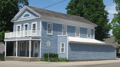 | Olde Store (John O'Ferrell Store) | 5.5 miles | 1975 |
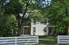 | Samuel P. Williams House | 6.2 miles | 1980 |
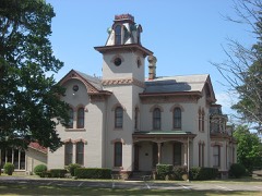 | John Badlam Howe Mansion | 6.5 miles | 1995 |
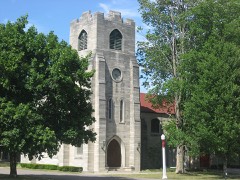 | St. James Memorial Chapel | 6.5 miles | 2001 |
| George and Margaret Wolcott House | 7.7 miles | 2020 |
| National Archives record | The nomination case file for reference 100008412 in Record Group 79. |
| LaGrange County | All 10 listed properties in this county. |