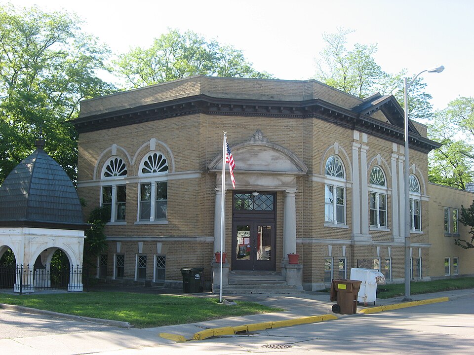
Built in 1907 (Neoclassical architecture). Listed on the National Register of Historic Places in 2013.
From the record
“Monticello Carnegie Library, also known as the White County Historical Society, is a former library in the historic Carnegie library building located at Monticello, Indiana. It was built in 1907, and is a two-story, Classical Revival style buff brick building on a raised basement.”
Wikipedia article Monticello Carnegie Library, CC BY-SA 4.0.
One of 5 National Register listings published here for White County · listed in 2013 · category: Building · built in 1907, Neoclassical architecture.
National Register reference number. 13000428 - assigned by the National Park Service when the property was listed.
Mines and
quarries near this property
1 within 5 miles
Regional context, not property-specific
evidence. The federal mineral resources record lists
1 working within 5 miles of Monticello Carnegie Library: 1 prospect.
None of them still produces. What was taken out: Stone, Crushed/Broken. Distance is straight-line from the
map coordinates, so a quarry counted here may appear on a neighbouring
settlement's page as well.
Regional context, not property-specific
evidence. The National Weather Service names
Monticello, the town this property stands in, in 31 storm reports between 1993 and 2025: 19 thunderstorm wind, 5 hail, 5 flash flood, 2 tornado.
No death or injury is recorded in these reports. Each account below is quoted exactly as the forecast office
filed it, from the NOAA Storm Events Database, and each date
opens the federal record of that event.
White County has several trees and power poles down. Reports of damage to houses and buildings. A church in Reynolds lost its steeple. A tree fell into the front room of a house. Siding was blown off a house in Reynolds. A tree fell onto a car in Monticello.
As the storms which produced wind damage in and west of Monticello merged and became stronger, resulting in several brief tornado touchdowns along US 24 east of Monticello. Spotters and law enforcement officials reported several weak funnels that would touchdown and lift. The first touchdown occurred just east of Monticello around 315 pm EDT with touchdowns at 320 pm EDT in Idaville and the last touchdown in White county occurring around 325 pm EDT in Burnettsville. Damage was confined to trees and tree limbs at the points of touchdown. The circulation proceeded into extreme western Cass county.
Emergency management reported a brief tornado touchdown 5 miles east of Monticello. Several witnesses said the tornado damaged some trees as it was on the ground for a few seconds.
No historic map-sheet match is published
for this property yet. That does not mean no map exists. This record needs
a coordinate-quality review before it can be joined to a sheet boundary.
Browse the county's mapped places while that work is
pending.
Listed places nearby
3 within 8 miles
Other National Register properties close
enough to walk or drive between, ordered by distance from this one. Both
positions come from the same geocoding pass that matched these properties
to their map sheets.
Listing record. National Park Service National Register of Historic Places, listed-properties dataset, current to 2026-05-22.
Map join. Address geocoded through the United States Census geocoder, then tested against the published boundary of every sheet in the USGS Historical Topographic Map Collection.
How this page is made. Listing fields come from federal records; map-sheet coverage is a labelled coordinate-to-boundary calculation, not a source-field claim.
Mines and quarries. USGS Mineral Resources Data System (MRDS) https://mrdata.usgs.gov/mrds/ A work of the United States government, no copyright under 17 U.S.C. 105.
Storms. NOAA National Centers for Environmental Information, Storm Events Database https://www.ncei.noaa.gov/stormevents/ A work of the United States government, no copyright under 17 U.S.C. 105. Narratives are quoted verbatim from the National Weather Service report and are not edited or summarised.
 Block