BlockBefore
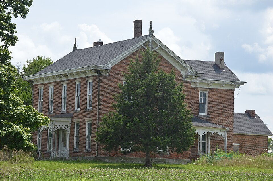
Photograph of Van Reed Farmstead
Photograph by Nyttend, Public domain. Via Wikimedia Commons.

Van Reed Farmstead

Listed on the National Register of Historic Places in 2015.

From the record

“Van Reed Farmstead is a historic home and farm located in Pine Township, Warren County, Indiana. The farmhouse was built in 1856, and is a large two-story, double pile Greek Revival style brick dwelling.”

Wikipedia article Van Reed Farmstead, CC BY-SA 4.0.

One of 4 National Register listings published here for Warren County · listed in 2015 · category: Building.

Sources: the Wikipedia article · the National Register database, National Park Service
The listing

  • Address. 5322 Old US 41, Williamsport, 47993
  • When was it listed? September 2015
  • Category. building
  • Township. Pine township
  • National Register reference number. 15000601 - assigned by the National Park Service when the property was listed.

The ground it stands on

73,342 words

The chapter on Pine Township in Counties of Warren, Benton, Jasper and Newton, Indiana : Historical and Biographical, published 1883 names Williamsport. This is what it says, exactly as the scans read.

The early lines of travel were along the Indian trails. These were clearly defined paths, about eighteen inches wide, and worn into the sod of the prairie, sometimes to the depth of eight or ten inches. Some trace of these trails are to be found yet in the county. One of these led down from Lake Michigan across the Kankakee, near the Baum bridge, and took nearly a direct course to the Indian village in Newton Township. Another connected this village with the one in the eastern part of the county, crossing the Iroquois west of the county seat, and re-crossing it some distance east. From the latter point the trail extended to the Monon River, and on to the Wabash. Another crossed the county through the " Forks settlement," toward La Porte. These were the principal ones, and were the principal guides between certain points until roads were established. Blazed and staked roads pioneered the way for those that were regularly laid out. The old " horse-head road " was, perhaps, the connecting link between the two classes of roads. This was in the eastern part of the county, and took its name from a horse skull which was placed upon a large bowlder, which was a conspicuous land-mark on this route. The first legally established road was the State road leading from Williamsport, on the Wabash River, and the head of .early navigation to Winamac, important at an early day, as the location of the land office. This road extended from the first-named place by the most available and direct route to the Falls of the Iroquois ; thence to the now extinct village of Saltillo, crossing the Iroquois again, at the old ford above the farm of John Groom, and crossing the Pinkamink on the old bridge at Saltillo, and thence by way of White Post, to Winamac. The Saltillo bridge was the first structure of its kind built in the county, the old grade which was built at either end still remaining to mark its site. The Indian trail road which led from Rensselear northward to the Kankakee River, was probably the second road. This crossed at Eaton's Ferry, or where the Baum bridge now is. Congress early granted a " three per cent fund" for the building of roads and bridges, and in 1835 Thomas Randle was appointed agent for the disbursement of this fund. Porter County was very much interested in having a bridge put across the river at this point ; this Randle refused to aid. He was accordingly displaced. Joseph Schipp moved over the river from Porter, and was appointed agent of this fund. Under the new agent, the bridge, three-quarters of a mile lona;, was started in December, 1837, and ยง!2,300 expended in getting the log piers built, and the stringers placed. It never got beyond this point, however, as that winter it took fire and was burned. A good, substantial bridge, "'21 feet long, now spans the river at this point, to the southern end of which, this county has made a long and expensive grade. The " Dunn bridge " crosses the river further east in Kankakee Township, but the low character of the ground on the north side of the river renders it less desirable as a route of travel than the other. The meanderings of the river make the cost of bridges an important item in the expenses of the county, but the various road-crossings are pretty well supplied with substantial wooden structures, while in the central and southern parts four durable iron bridges afford a safe and sightly passage over the Irotiuois and other streams. But with all that could be profitably done for the highways of the county, the prosperity of the community settled here languished for the advantages of a railroad. When the Louisville, New Albany & Chicago made its way along its eastern border, the county had greater facilities, but its people had still a tedious journey over roads that were impassable to loaded teams during a large share of the time, and the contrast between the more favored territory and Jasper intensified the already considerable anxiety felt for better facilities for communication with the rest of the world.

Passage source: Counties of Warren, Benton, Jasper and Newton, Indiana : Historical and Biographical, published 1883.

Saltillo, Davidsonville. - The settlement in what is now Gillam Township was the earliest one in Jasper County, and while of marked importance during the first years after the county was formed, it did not maintain its early prestige after the organization of the county. Until that period, however, it was the point for voting, and Donahue held the ofiBce of Justice of the Peace for several years, which made it the seat of justice for the time. The families of John Gillam and Joseph McJimsey came about 1836, and others soon after. The State road from Williamsport to Winamac went through this settlement, which gave a shght impetus toward the growth of a village. The weekly mail, which was carried through the village, gave color to its " manifest destiny," and Saltillo came into being. It was a spontaneous growth, but never became a matter of record. A house or two and a post office were all that gave importance to the location, the site of which is now only marked by the old bridge grade, nearly two hundred yards south of where the Rensselaer & FrancesviUe road now crosses the Pinkamink.

Passage source: Counties of Warren, Benton, Jasper and Newton, Indiana : Historical and Biographical, published 1883.

Machine-read from a century-old scan, so expect the errors a machine makes: misspelled names, dropped words, stray characters.

Read the whole chapter on Pine Township - 73,342 words on its settlement, mills, schools and churches.

Storms near this property

33 since 1997

Regional context, not property-specific evidence. The National Weather Service names Williamsport, the town this property stands in, in 33 storm reports between 1997 and 2025: 13 thunderstorm wind, 11 hail, 7 flood, 2 flash flood. No death or injury is recorded in these reports. Each account below is quoted exactly as the forecast office filed it, from the NOAA Storm Events Database, and each date opens the federal record of that event.

WhenEvent Place namedHarm What the report says
March 2006FloodWilliamsport$100,000no account filed
June 1998Thunderstorm WindWilliamsport$30,000Thunderstorm winds blew roof off apartment building.
March 2025Thunderstorm WindWilliamsport$15,000Barn and tree damage across the county caused by thunderstorm wind gusts. The barn was located at this location.
February 2007FloodWilliamsport$10,000The Wabash River flooded in Warren County. The river remained in flood into March. Crests were over 5 feet above flood stage.
January 2007FloodWilliamsport$10,000The Wabash River in Warren County flooded during much of January. Crests were as high as 8.8 feet above flood stage.
March 2007FloodWilliamsport$10,000The Wabash River remained flooded in Warren County from February through March, dipping below flood stage for only brief periods during the month. Crests were nearly 8.5 feet above flood stage.
April 2007FloodWilliamsport$5,000Flooding returned to the Wabash River in Warren County during late April. The crest reached two and a half feet above flood stage.
April 2006Thunderstorm WindWilliamsport$5,000A roof was damaged.
July 2002Flash FloodWilliamsport$2,000no account filed
June 2019Thunderstorm WindWilliamsport$1,000Utility lines were blown down near Saint Vincent Williamsport hospital on Ross Avenue, just east of the hospital, due to damaging thunderstorm wind gusts.
May 2019Thunderstorm WindWilliamsport$1,000Several 4 to 6 inch tree limbs were snapped near Oakwood Drive in Williamsport due to damaging thunderstorm wind gusts. This report was relayed by social media.
April 2007FloodWilliamsport$1,000Flooding continued from March on the Wabash River in Warren County. The crest reached eight and a half feet above flood stage.
May 1998Thunderstorm WindWilliamsport$500Trees and power lines blown down.
May 2023HailWilliamsport-Relayed via social media.
April 2020HailWilliamsport-Relayed via Twitter.
April 2006Thunderstorm WindWilliamsport-A gust to 68 mph was measured at the county emergency operations center. Some minor structural damage was reported, but no estimates were available.
September 2005Thunderstorm WindWilliamsport-Trees were downed.
May 2017HailWilliamsport-no account filed
June 2014HailWilliamsport-no account filed
April 2007HailWilliamsport-no account filed
April 2006HailWilliamsport-no account filed
May 2005HailWilliamsport-no account filed
April 2003Thunderstorm WindWilliamsport-no account filed
April 2003HailWilliamsport-no account filed
June 2003Flash FloodWilliamsport-no account filed
May 2003HailWilliamsport-no account filed
July 2003Thunderstorm WindWilliamsport-no account filed
June 2002Thunderstorm WindWilliamsport-no account filed
July 2001Thunderstorm WindWilliamsport-no account filed
May 2000HailWilliamsport-no account filed
June 1997FloodWilliamsport-no account filed

Every storm recorded in Warren County

Map coverage status

No historic map-sheet match is published for this property yet. That does not mean no map exists. This record needs a coordinate-quality review before it can be joined to a sheet boundary. Browse the county's mapped places while that work is pending.

Listed places nearby

2 within 8 miles

Other National Register properties close enough to walk or drive between, ordered by distance from this one. Both positions come from the same geocoding pass that matched these properties to their map sheets.

Photograph PropertyDistance Listed
Andrew Brier House2.4 miles1986
Warren County Courthouse7.9 miles2008

Sources for this property

National Archives recordThe nomination case file for reference 15000601 in Record Group 79.
Wikipedia articleCommunity-written account of this property, licensed CC BY-SA.
Warren CountyAll 4 listed properties in this county.

Provenance

  • Listing record. National Park Service National Register of Historic Places, listed-properties dataset, current to 2026-05-22.
  • Map join. Address geocoded through the United States Census geocoder, then tested against the published boundary of every sheet in the USGS Historical Topographic Map Collection.
  • How this page is made. Listing fields come from federal records; map-sheet coverage is a labelled coordinate-to-boundary calculation, not a source-field claim.
  • Storms. NOAA National Centers for Environmental Information, Storm Events Database https://www.ncei.noaa.gov/stormevents/ A work of the United States government, no copyright under 17 U.S.C. 105. Narratives are quoted verbatim from the National Weather Service report and are not edited or summarised.