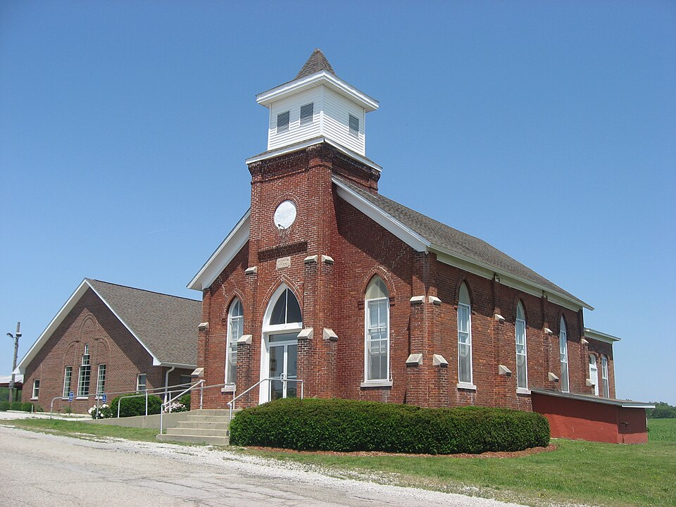
Listed on the National Register of Historic Places in 1979.
From the record
“Salem Methodist Episcopal Church, also known as Salem United Methodist Church, is a historic United Methodist church in Helt Township, Vermillion County, Indiana. The church was built in 1878 to house Vermillion County's first Methodist congregation, which was established in the 1820s.”
Wikipedia article Salem Methodist Episcopal Church (Clinton, Indiana), CC BY-SA 4.0.
One of 9 National Register listings published here for Vermillion County · listed in 1979 · category: Building.
National Register reference number.79000022- the number the National Park Service assigned this property when it was listed, and the key its nomination file is catalogued under at the National Archives.
1819 - Samuel Ryerson, who died January 31, 1862, at Clinton. His wife Phebe died in the autumn of 1874. aged seventy-nine years. She was a remarkable woman. At the age of twelve years .she had never heard one pray. At that time she attended a Methodist meeting, where the expected preacher did not arrive, and the class leader sang and prayed, which was the means of her conviction and conversion and she remained a zealous member of the church all of her life. She and her husband formed the first Methodist Episcopal class on Helt's prairie, consisting of eight persons, soon after their settlenient here. A short time before her death she willed one thousand five hundred dollars to the missionary society, five hundred dollars to Asbury Uni\-ersity, two hundred dollars to the educational fund of this county and two hundred dollars to the Biblical Institute at Evanston. Illinois, besides other sums to various individuals. Mathew Harbison came this year. Joseph Harbison was born in this township in 1834.
Regional context, not property-specific
evidence. The federal mineral resources record lists
5 workings within 5 miles of Salem Methodist Episcopal Church: 4 producers, 1 plant.
All of them still produce. What was taken out: Sand and Gravel, Construction, Stone, Clay, Clay. Distance is straight-line from the
map coordinates, so a quarry counted here may appear on a neighbouring
settlement's page as well.
Regional context, not property-specific
evidence. The National Weather Service names
Clinton, the town this property stands in, in 42 storm reports between 1995 and 2024: 19 thunderstorm wind, 12 hail, 4 flash flood, 4 flood.
The reports record 1 injury. Each account below is quoted exactly as the forecast office
filed it, from the NOAA Storm Events Database, and each date
opens the federal record of that event.
A woman from Clinton was taken to the hospital for burns after she was struck by lightning. The Daily Clintonian newspaper reported that she was standing under a tree when the event occurred. She was transported to Union Hospital Clinton and later taken, by ground, to Methodist Hospital in Indianapolis for burns.
Flooded Brouilletts Creek engulfed State Road 63 and washed portion of it away. Rangeline Road had chunks of the road washed out. In Clinton, Feather Creek overflowed its banks and forced residents from their homes. 150 to 175 residents were affected by flooding.
Thunderstorm winds uprooted a large tree, which landed on top of a small single-story house near McDonald Lake near Clinton. The impact caused the house to split in half and a female occupant to hit the ceiling before she became entrapped by bedroom furniture. The tree itself landed about 6 feet away from the occupant. A newly purchased cell phone was within reach and she was able to summon help to extricate her from the now uninhabitable dwelling. The tree killed a kitten that she had rescued during June flooding. Another cat was injured. The fire department that has jurisdiction could not reach the house due to other fallen trees blocking the route, thus others had to called in.
Lightning struck the Daily Clintonian building in the 400 block of South Main Street. The fire was on the understructure of the roof. Some of the damage included 13 computers.
The Daily Clintonian reported thunderstorm wind gust damage in the south end of Clinton. A metal storage building was blown over in the 1500 block of South Fourth Street. Also, a tree was knocked down onto a trailer and house windows were also broken out in the same location. Trees and power lines were reported to be downed across much of southern Vermillion County.
Flash flooding occurred as water covered South Main Street in Clinton due to heavy rain. Flash flooding had damaged numerous homes, buildings, bridges, and roads. Feather Creek flooded.
Many streets south of Elm Street were impassable because of downed trees. Firefighters, police, and street department employees worked through the night to clear streets and provide traffic control because of downed power lines. The local Fire Chief estimated that 100 to 200 trees had fallen from the storm. Several homes and cars were hit by trees.
No historic map-sheet match is published
for this property yet. That does not mean no map exists. This record needs
a coordinate-quality review before it can be joined to a sheet boundary.
Browse the county's mapped places while that work is
pending.
Listed places nearby
4 within 8 miles
Other National Register properties close
enough to walk or drive between, ordered by distance from this one. Both
positions come from the same geocoding pass that matched these properties
to their map sheets.
Listing record. National Park Service National Register of Historic Places, listed-properties dataset, current to 2026-05-22.
Map join. Address geocoded through the United States Census geocoder, then tested against the published boundary of every sheet in the USGS Historical Topographic Map Collection.
How this page is made. Listing fields come from federal records; map-sheet coverage is a labelled coordinate-to-boundary calculation, not a source-field claim.
Mines and quarries. USGS Mineral Resources Data System (MRDS) https://mrdata.usgs.gov/mrds/ A work of the United States government, no copyright under 17 U.S.C. 105.
Storms. NOAA National Centers for Environmental Information, Storm Events Database https://www.ncei.noaa.gov/stormevents/ A work of the United States government, no copyright under 17 U.S.C. 105. Narratives are quoted verbatim from the National Weather Service report and are not edited or summarised.
 Block