
BlockBefore
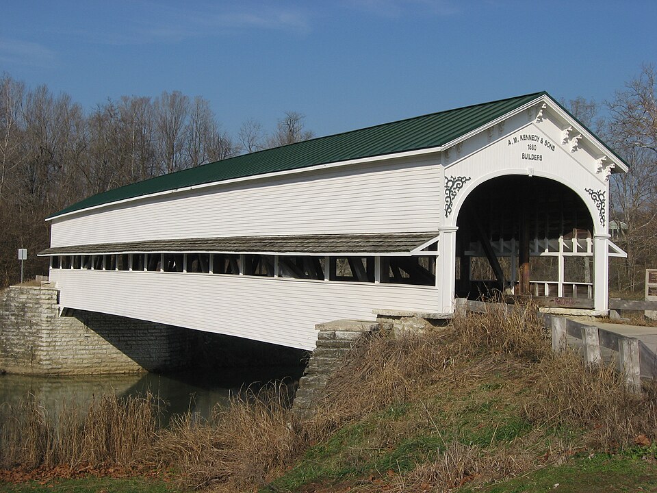
Photograph of Westport Covered Bridge
Photograph by Nyttend, Public domain. Via Wikimedia Commons.

Westport Covered Bridge

Built in 1880. Listed on the National Register of Historic Places in 1982.

From the record

“Westport Covered Bridge is a historic covered bridge located in Sand Creek Township, Decatur County, Indiana. It was built in 1880, and is a single span, Burr arch bridge on limestone abutments.”

Wikipedia article Westport Covered Bridge, CC BY-SA 4.0.

One of 10 National Register listings published here for Decatur County · listed in 1982 · category: Structure · built in 1880, by A.M. Kennedy and Sons.

Sources: the Wikipedia article · the case file at the National Archives · the National Register database, National Park Service

The listing

  • What is counted as historic. The nomination lists 1 structure as contributing to the listing.
  • Address. E. of Westport, Westport, 47283
  • When was it listed? June 1982
  • Category. structure
  • Township. Sandcreek township
  • When was it built? 1880
  • Architect. A.M. Kennedy and Sons
  • National Register reference number. 82000031 - the number the National Park Service assigned this property when it was listed, and the key its nomination file is catalogued under at the National Archives.

The ground it stands on

2,767 words

The chapter on Sandcreek Township in History of Decatur County, Indiana : Its People, Industries and Institutions, published 1915 names Westport. This is what it says, exactly as the scans read.

Samuel Stevens built a brick house in 1834 and about the same time Simeon Sharp opened a tavern where Westport now stands. Elijah Davis and John Robbins both started water-mills and some time after William Robbins built a horse-mill, so that the early settlers were not altogether dependent upon the waters of Sand creek and Millstone creek for their bread. The first church in the township was organized by Samuel Strickland, of the denomination then styled "Campbellites."

Passage source: History of Decatur County, Indiana : Its People, Industries and Institutions, published 1915.

Westport is noted for its excellent stone cpiarries in close pro.ximity to the town. .The product of these quarries is a high-grade building stone, which will bear favorable comparison with that of any other section of the state. It is also used quite extensively for curb and gutter, and many car loads of crushed stone are shipped from the quarries annually. At present it is under the management of a Cincinnati corporation and bears the name of the Westport Stone Company. John Ballman, of Cincinnati, is the present superintendent and he is ablv assisted bv J. L. Tackson, of Westport. (10)

Passage source: History of Decatur County, Indiana : Its People, Industries and Institutions, published 1915.

Machine-read from a century-old scan, so expect the errors a machine makes: misspelled names, dropped words, stray characters.

Read the whole chapter on Sandcreek Township - 2,767 words on its settlement, mills, schools and churches.

Storms near this property

24 since 1993

Regional context, not property-specific evidence. The National Weather Service names Westport, the town this property stands in, in 24 storm reports between 1993 and 2025: 20 thunderstorm wind, 2 flood, 1 tornado, 1 heavy rain. No death or injury is recorded in these reports. Each account below is quoted exactly as the forecast office filed it, from the NOAA Storm Events Database, and each date opens the federal record of that event.

WhenEvent Place namedHarm What the report says
June 2023Thunderstorm WindWestport$50,000Half mile wide swath of trees downed by thunderstorm wind gusts. Estimated 200-250 total trees.
April 1996Thunderstorm WindWestport$50,000no account filed
June 2010Thunderstorm WindWestport$36,000Power lines and trees were reported down in Westport due to damaging thunderstorm wind gusts. The town was without power and some of the downed trees damaged a few homes. This report came in via WebEOC.
July 2001Thunderstorm WindWestport$20,000no account filed
October 2001Thunderstorm WindWestport$20,000no account filed
March 2025Thunderstorm WindWestport$15,000Many trees of unknown size and power lines downed by thunderstorm wind gusts across the immediate area.
April 2020Thunderstorm WindWestport$15,000House with half of the roof torn off as well as barn damage nearby due to thunderstorm wind gusts.
August 2006Thunderstorm WindWestport$10,000Several trees and power lines were downed, and structural damage occurred.
May 2014Thunderstorm WindWestport$7,000Trees were downed in this location due to damaging thunderstorm wind gusts.
November 2013Thunderstorm WindWestport$6,000Multiple trees were reported down in this location due to damaging thunderstorm wind gusts.
June 2018FloodWestport$5,000Iron Mine Road or County Road 600 West was closed between County Roads 950 South and 1100 South due to flood damage from heavy rainfall.
July 2008Thunderstorm WindWestport$5,000Trees, tree limbs, and utility lines were blown down by thunderstorm winds.
March 2020Thunderstorm WindWestport$2,000A tree was downed by thunderstorm wind gusts and was blocking State Road 3. Heavy rains in the hours preceding the wind allowed the tree to be uprooted rather easily.
May 2013Thunderstorm WindWestport$2,000A couple trees were downed in southwest Decatur County due to damaging thunderstorm wind gusts.
June 2010Thunderstorm WindWestport$1,500An eight inch diameter tree limb from a live, maple tree was reported down on a house due to damaging thunderstorm wind gusts. No additional information about damage to the house was received.
August 2009FloodWestport$500The Decatur County EMA reported water over roadways located across the central and southern portion of the county. Rainfall rates of over two inches per hour were also observed.
June 2010Heavy RainWestport-Rainfall of 1.5 inches was measured in Westport.
April 2006Thunderstorm WindWestport-A large tree was downed.
May 2005Thunderstorm WindWestport-Trees and power lines were blown down. One tree, which was 93 feet tall and over 100 years old, came within inches of crushing a home when it was uprooted by the storm.
May 2005Thunderstorm WindWestport-Several 14-inch diameter trees were uprooted by thunderstorm winds.
July 2005Thunderstorm WindWestport-Trees and power lines were downed.
March 1997Thunderstorm WindWestport-no account filed
April 1996Tornado (F0)Westport-no account filed
August 1993Thunderstorm WindWestport-no account filed

Every storm recorded in Decatur County

Map coverage status

No historic map-sheet match is published for this property yet. That does not mean no map exists. This record needs a coordinate-quality review before it can be joined to a sheet boundary. Browse the county's mapped places while that work is pending.

Sources for this property

National Archives recordThe nomination case file for reference 82000031 in Record Group 79.
Wikipedia articleCommunity-written account of this property, licensed CC BY-SA.
Decatur CountyAll 10 listed properties in this county.

Provenance

  • Listing record. National Park Service National Register of Historic Places, listed-properties dataset, current to 2026-05-22.
  • Map join. Address geocoded through the United States Census geocoder, then tested against the published boundary of every sheet in the USGS Historical Topographic Map Collection.
  • How this page is made. Listing fields come from federal records; map-sheet coverage is a labelled coordinate-to-boundary calculation, not a source-field claim.
  • Storms. NOAA National Centers for Environmental Information, Storm Events Database https://www.ncei.noaa.gov/stormevents/ A work of the United States government, no copyright under 17 U.S.C. 105. Narratives are quoted verbatim from the National Weather Service report and are not edited or summarised.