BlockBefore
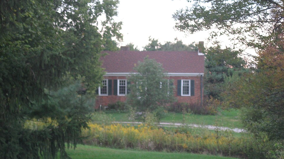
Photograph of William Lowry House
Photograph by Nyttend, Public domain. Via Wikimedia Commons.

William Lowry House

Listed on the National Register of Historic Places in 1982.

From the record

“William Lowry House, also known as the Kniese-Chaudhuri House, is a historic home located in Posey Township, Fayette County, Indiana. It was built about 1825, and is a one-story, five-bay, L-plan, gable-roofed, Federal style brick cottage.”

Wikipedia article William Lowry House (Bentonville, Indiana), CC BY-SA 4.0.

One of 9 National Register listings published here for Fayette County · listed in 1982 · category: Building.

Sources: the Wikipedia article · the case file at the National Archives · the National Register database, National Park Service · the Wikipedia article
The listing

  • What is counted as historic. The nomination lists 1 building as contributing to the listing.
  • Listed as. Lowry, William, House - the National Register files a house under its owner's surname.
  • Address. Kniese Rd., Bentonville, 47357
  • When was it listed? February 1982
  • Category. building
  • Township. Posey township
  • Architectural style. Federal architecture
  • National Register reference number. 82000036 - the number the National Park Service assigned this property when it was listed, and the key its nomination file is catalogued under at the National Archives.

The ground it stands on

4,982 words

The chapter on Posey Township in History of Fayette County, Indiana: Containing a History of the Townships, Towns, Villages, Schools, Churches, Industries, Etc.; Portraits of Early Settlers and Prominent Men; Biographies, Etc., Etc. .., published 1885 names Bentonville. This is what it says, exactly as the scans read.

The Mungers, among the first to enter and settle upon land in the " New Purchase, " were from Rutland County, Vt. Edmund K. , with family, settled about one and a half miles southeast of the present site of Bentonville in the fall of 1821. He was the son of Brig.-Gen. Edward Munger, of Vermont, who in the early history of Ohio went to Belpre, and there raised and disciplined an army, with headquarters near Dayton. The Mungers settled for a time in that locality, where now, in Montgomery and Greene Counties (Ohio), a number of their descendants reside. Edward and Lazarus, now residents of this township' are sons of Edmund K.

Passage source: History of Fayette County, Indiana: Containing a History of the Townships, Towns, Villages, Schools, Churches, Industries, Etc.; Portraits of Early Settlers and Prominent Men; Biographies, Etc., Etc. .., published 1885.

George Van Buskirk, Sr., and family, from Kentucky, settled in the vicinity of Cambridge City in 1815, and in 1831 a son, George, Jr., settled in the vicinity of where he now resides just west of Bentonville, where he has played well his part in converting the wilderness of that day into the beautiful farms of the present.

Passage source: History of Fayette County, Indiana: Containing a History of the Townships, Towns, Villages, Schools, Churches, Industries, Etc.; Portraits of Early Settlers and Prominent Men; Biographies, Etc., Etc. .., published 1885.

Machine-read from a century-old scan, so expect the errors a machine makes: misspelled names, dropped words, stray characters.

Read the whole chapter on Posey Township - 4,982 words on its settlement, mills, schools and churches.

Storms near this property

10 since 1999

Regional context, not property-specific evidence. The National Weather Service names Bentonville, the town this property stands in, in 10 storm reports between 1999 and 2025: 5 thunderstorm wind, 3 tornado, 1 hail, 1 flood. No death or injury is recorded in these reports. Each account below is quoted exactly as the forecast office filed it, from the NOAA Storm Events Database, and each date opens the federal record of that event.

WhenEvent Place namedHarm What the report says
June 2019Tornado (EF0)Bentonville$50,000The tornado briefly touched down damaging an older church building on North County Road 550 West. The roof collapsed within the building as the north wall was blown out. There was a large amount of splatter on the east facing wall. A piece of metal was located in a tree around forty yards to the west of the church. Debris from the church was lifted and scattered northward across the cemetery and up to 200 yards into a nearby field.
May 2024Tornado (EF0)Bentonville$25,000The tornado began along North County Road 350 West, about 3 miles northeast of Bentonville, where tree damage was observed. Additional tree damage occurred to the east of Paul Road on the Fayette and Wayne County border. The tornado moved into Wayne County at 1910EST and continued northeast before ending about 1 mile north of Milton at 1913EST.
March 2025Thunderstorm WindBentonville$15,000A barn was heavily damaged when a section of its roof panels was blown off and one of its exterior walls was collapsed.
February 2023Thunderstorm WindBentonville$10,000A few trees and powerlines were downed.
May 1999Tornado (F0)Bentonville$10,000A tornado touched down in a rural area toppling several trees. Numerous other trees were down across the county due to thunderstorm winds.
July 2016Thunderstorm WindBentonville$5,000Numerous trees were downed across the northern part of Fayette County.
April 2025FloodBentonville$3,000Several roads were closed in Bentonville due to high water. One home had to be evacuated due to rising waters.
August 2021Thunderstorm WindBentonville$3,000A few trees were downed along West County Road 600 N.
February 2014Thunderstorm WindBentonville$1,000A large limb was downed due to thunderstorm winds.
March 2011HailBentonville-no account filed

Every storm recorded in Fayette County

Map coverage status

No historic map-sheet match is published for this property yet. That does not mean no map exists. This record needs a coordinate-quality review before it can be joined to a sheet boundary. Browse the county's mapped places while that work is pending.

Listed places nearby

6 within 8 miles

Other National Register properties close enough to walk or drive between, ordered by distance from this one. Both positions come from the same geocoding pass that matched these properties to their map sheets.

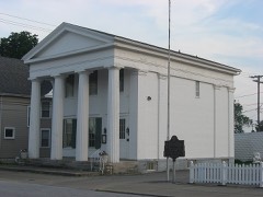
Photograph PropertyDistance Listed
Roberts Park5.3 miles2014
Newkirk Mansion6.6 miles2021
Connersville Downtown Historic District6.6 miles2017
Fayette County Courthouse6.7 miles2006
Trinity Episcopal Church & Parish House6.7 miles2022
Canal House6.8 miles1973

Sources for this property

National Archives recordThe nomination case file for reference 82000036 in Record Group 79.
Wikipedia articleCommunity-written account of this property, licensed CC BY-SA.
Fayette CountyAll 9 listed properties in this county.

Provenance

  • Listing record. National Park Service National Register of Historic Places, listed-properties dataset, current to 2026-05-22.
  • Map join. Address geocoded through the United States Census geocoder, then tested against the published boundary of every sheet in the USGS Historical Topographic Map Collection.
  • How this page is made. Listing fields come from federal records; map-sheet coverage is a labelled coordinate-to-boundary calculation, not a source-field claim.
  • Storms. NOAA National Centers for Environmental Information, Storm Events Database https://www.ncei.noaa.gov/stormevents/ A work of the United States government, no copyright under 17 U.S.C. 105. Narratives are quoted verbatim from the National Weather Service report and are not edited or summarised.