BlockBefore
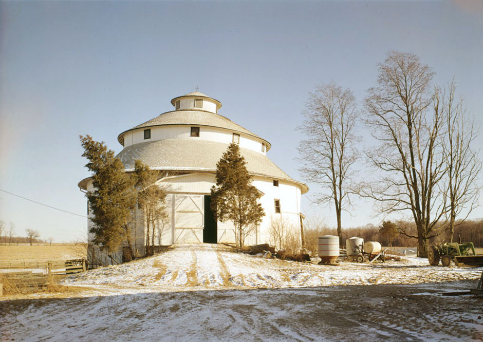
Photograph of Thomas Ranck Round Barn
Photograph by Jack Boucher, Public domain. Via Wikimedia Commons.

Thomas Ranck Round Barn

Listed on the National Register of Historic Places in 1983.

From the record

“The Thomas Ranck Round Barn is a round barn in Waterloo Township near the Fayette-Wayne County, Indiana county line. It is one of many round barns built in Indiana during the late 19th and early 20th centuries.”

Wikipedia article Thomas Ranck Round Barn, CC BY-SA 4.0.

One of 9 National Register listings published here for Fayette County · listed in 1983 · category: Building.

Sources: the Wikipedia article · the case file at the National Archives · the National Register database, National Park Service
The listing

  • What is counted as historic. The nomination lists 1 building as contributing to the listing.
  • Listed as. Ranck, Thomas, Round Barn - the National Register files a house under its owner's surname.
  • Address. N of Brownsville on CR 500 N., Brownsville, 47325
  • When was it listed? January 1983
  • Category. building
  • Township. Waterloo township
  • National Register reference number. 83000030 - the number the National Park Service assigned this property when it was listed, and the key its nomination file is catalogued under at the National Archives.

The ground it stands on

7,163 words

The chapter on Waterloo Township in History of Fayette County, Indiana: Containing a History of the Townships, Towns, Villages, Schools, Churches, Industries, Etc.; Portraits of Early Settlers and Prominent Men; Biographies, Etc., Etc. .., published 1885 names Brownsville. This is what it says, exactly as the scans read.

All of the territory of the township as it now is which lies east of a line parallel to the eastern boundary of Jennings Township was taken from Brownsville Township, and the rest from Harrison. In position it is the northeastern township of the county, Wayne County lying north of it, Qnion east, Jennings and Cohuersville Townships south, and the West Fork of Whitewater River west. It is a small subdivison having an area of a little more than sixteen square miles. The face of the country is rolling. Its principal streams are West Fork and Nolan's Fork; both are on its western border. Simpson's and Williams Creeks - small streams^drain portions of the land. The extreme southeastern portion of the township is crossed by the C. H. & I. R. R., and within its confines are situated the hamlet of Waterloo and the major part of the hamlet- of Springerville.

Passage source: History of Fayette County, Indiana: Containing a History of the Townships, Towns, Villages, Schools, Churches, Industries, Etc.; Portraits of Early Settlers and Prominent Men; Biographies, Etc., Etc. .., published 1885.

Chapel. This chapel building is a large frame, located in the northeastern part of the township, and at which is a burying- ground of considerable age. As far back as we can trace the history of the original class or society, it was an appointment along with Waterloo, a class at John Quinns, Brownsville, Bethel, Alquina. Veatches (Mt. Garrison), and others further south. The old Whitewater Circuit was formed in 1806 or 1807; just at what time the class at Robinson's was organized or first visited by the preachers who traveled the circuit, in the absence of records we cannot state, but it was some years before the formation of the Connersville Circuit in 1822. Sixty years ago the village of Brownsville, just east in Union County, was among the most flourishing societies on the circuit; the preacher often lived there. A meeting-house at Robinson's was built early; we find a reference to it in the decade between 1820 and 1830. The present house of worship there was built in 1845. The following list contains the names of some of the earlier preachers who traveled the old Whitewater Circuit and circuits growing out of it, on which Robinson's was an appointment:

Passage source: History of Fayette County, Indiana: Containing a History of the Townships, Towns, Villages, Schools, Churches, Industries, Etc.; Portraits of Early Settlers and Prominent Men; Biographies, Etc., Etc. .., published 1885.

Machine-read from a century-old scan, so expect the errors a machine makes: misspelled names, dropped words, stray characters.

Read the whole chapter on Waterloo Township - 7,163 words on its settlement, mills, schools and churches.

Map coverage status

No historic map-sheet match is published for this property yet. That does not mean no map exists. This record needs a coordinate-quality review before it can be joined to a sheet boundary. Browse the county's mapped places while that work is pending.

Listed places nearby

6 within 8 miles

Other National Register properties close enough to walk or drive between, ordered by distance from this one. Both positions come from the same geocoding pass that matched these properties to their map sheets.

Photograph PropertyDistance Listed
Roberts Park5.2 miles2014
Connersville Downtown Historic District7.0 miles2017
Trinity Episcopal Church & Parish House7.0 miles2022
Fayette County Courthouse7.2 miles2006
Canal House7.2 miles1973
Newkirk Mansion7.4 miles2021

Sources for this property

National Archives recordThe nomination case file for reference 83000030 in Record Group 79.
Wikipedia articleCommunity-written account of this property, licensed CC BY-SA.
Fayette CountyAll 9 listed properties in this county.

Provenance

  • Listing record. National Park Service National Register of Historic Places, listed-properties dataset, current to 2026-05-22.
  • Map join. Address geocoded through the United States Census geocoder, then tested against the published boundary of every sheet in the USGS Historical Topographic Map Collection.
  • How this page is made. Listing fields come from federal records; map-sheet coverage is a labelled coordinate-to-boundary calculation, not a source-field claim.