BlockBefore
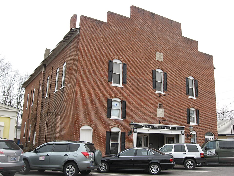
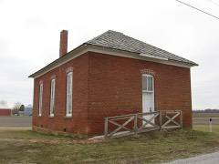
Photograph of Town Hall
Photograph by Nyttend, Public domain. Via Wikimedia Commons.

Town Hall (Castle Hall)

Listed on the National Register of Historic Places in 1983.

From the record

One of 13 National Register listings published here for Boone County · listed in 1983 · category: Building.

Sources: the case file at the National Archives · the National Register database, National Park Service · the Wikipedia article

The listing

  • What is counted as historic. The nomination lists 1 building as contributing to the listing.
  • Address. 65 E. Cedar St., Zionsville, 46077
  • When was it listed? June 1983
  • Category. building
  • Town. Zionsville town
  • National Register reference number. 83000115 - the number the National Park Service assigned this property when it was listed, and the key its nomination file is catalogued under at the National Archives.

The ground it stands on

37,254 words

The chapter on Zionsville Town in Early Life and Times in Boone County Indiana, published 1861 names Zionsville. This is what it says, exactly as the scans read.

The above town is situated in Worth Township, on the Indianapolis, Cincinnati & Lafayette Railroad, seven miles southeast of Lebanon and about the same distance northwest of Zionsville, surrounded by one of the best agricultural districts in the county. It is the center oi a large local trade and where the township elections are held, aud in fact all the elections when held in the county. It has been for years the central point for Worth Township. Whitestown was laid out in the year 1851, or about the time the railroad was built. The first plat was on the land of Abram Nese. The first merchant was Harrison Spencer, followed soon after by Henry' Lucus and William Laughner. The first grist mill built here was by Isaac Dye and Alfred Osburn, which was in a few years burned down; rebuilt by Henry Lucus. The present mill was built by J. W. Bowser, who operated it successfully for years and built up for it a good reputation at home and abroad. He sold it in October, 1886, to Riley & Vaughn. It has all the new milling facilities for making the best flour in the state. It is valued at $12,000. Among those doing business in an early day at Whitestown in the various capacities we might mention the following merchants: W. J.Givens, Daniel Echman, Ceaser Echman, F. M. Moody, Neese & Keefe, J. T. Ross, Dr. I. T. Ross, Dr. Starkey, Dr. Larimore, J. S. Hardy, who is now practicing. Postmasters, Henry Lucus, Dr. Ross, Henry Walters, S. M. Trout. The present one is J. O. Barb. Hotel, G. W. H. Roberts. The school house here is an excellent one of brick, and fully up to the times in every respect, as well as the churches and other buildings. The annual business transactions here amount to thousands of dollars, including the railroad business, which alone is very large.

Passage source: Early Life and Times in Boone County Indiana, published 1861.

Eagle Village, one of the oldest towns in Boone County, was laid out in 1831. It is located on the Michigan Road, in the southeast part of Eagle Township, about one mile east of Zionsville. Until 1852, when the Indianapolis, Cincinnati & Lafayette Railroad was built, the village was a place of some importance. From the year 1850, when it was at its zenith, it gradually went down, until now there are but few houses left. Many of the buildings were removed from there to Zionsville in 1852, when the latter place was laid out. Among the early merchants and business men of Eagle Village, most of whom are now deceased, we find the following: Daniel and James M. Larimore, Reuben Price, J. F. Daugherty, John Harden, Addison Nicholas, J. B. Pitzer, John P. Welch, Oel Thayer, T. P. Miller and Fielding Utterback, all of whom sold goods from 1835 until 1851. Among the physicians who practiced here from time to time, were H. G. Larimore, S. W. Rodman, Jeremiah Larimore, J. M. Gaston, Nathan Crosby and Dr. Johnson. H.G. Larimore died in Fayette County, Ind., in 1874, aged near ninety years. S. W. Rodman lives in Washington Territory. J. M. Gaston, who did not remain long in Eagle Village, lives in Indianapolis. Dr. Johnson's whereabouts are unknown. Jeremiah Larimore died in Indianapolis about the year 1880. He is buried at Mount's Run, in this county. Nathan Crosby, quite an old man, lives in Zionsville. He came from the East to Eagle Village in 1849. Of the early merchants we give the following: Daniel Larimore came from Fayette County, Ind., in 183-, was engaged in business only a few years when he died. He died in 1839, and is buried at Eagle Village. J. M., his son, succeeded him, and was engaged in active business until March, 1849, when he died of consumption. He was a fine-looking man, was never married, and is buried by the side of his father. He was the first Odd Fellow in Boone County. J. F. Daugherty came in 1836, and was in business a number of years. He finally moved to Zionsville, where he sold goods a number of years. He now resides in Indianapolis. John Harden engaged in business in 1842. He died in Ohio, February, 1877, and is buried at Zionsville, Boone County. Fielding Utterback was engaged in business several years. He was elected county sheriff in 1845. He went West and died there ten or fifteen years ago. Oel Thayer came to Boone County in 1839; was first a merchant in Clarkstown, then in Eagle Village. He finally removed ta Lebanon, where he died February 4, 1877. John Welch engaged in business with J. B. Pitzer (his brother-in-law), in 1846. He died in September, 1850, and is buried on Eagle Creek, six miles southwest of Zionsville. J. B. Pitzer was in business several years. He was elected county auditor in 1863. He resides in Zionsville, and is seventy-four years old. er. Miller was born in Tennessee. He came with his father to Eagle

Passage source: Early Life and Times in Boone County Indiana, published 1861.

Machine-read from a century-old scan, so expect the errors a machine makes: misspelled names, dropped words, stray characters.

Read the whole chapter on Zionsville Town - 37,254 words on its settlement, mills, schools and churches.

Mines and quarries near this property

1 within 5 miles

Regional context, not property-specific evidence. The federal mineral resources record lists 1 working within 5 miles of Town Hall (Castle Hall): 1 past producer. None of them still produces. What was taken out: Sand and Gravel, Construction. Distance is straight-line from the map coordinates, so a quarry counted here may appear on a neighbouring settlement's page as well.

Where SiteCommodity StatusRecorded
Routh Sand and Gravel PitSand and Gravel, ConstructionPast Producer

Every working recorded in Boone County

Storms near this property

15 since 1993

Regional context, not property-specific evidence. The National Weather Service names Zionsville, the town this property stands in, in 15 storm reports between 1993 and 2023: 5 thunderstorm wind, 5 hail, 4 lightning, 1 flood. No death or injury is recorded in these reports. Each account below is quoted exactly as the forecast office filed it, from the NOAA Storm Events Database, and each date opens the federal record of that event.

WhenEvent Place namedHarm What the report says
May 2005LightningZionsville$175,000Lightning struck a home in the Fox Hollow Subdivision of Zionsville, Indiana. Significant damage was caused by the ensuing fire.
June 2006LightningZionsville$100,000A house was heavily damaged by a lightning strike-induced fire.
May 2005LightningZionsville$85,000Lightning struck a home in the Brittany Chase Subdivision of Zionsville, Indiana. The strike sparked a small fire in the attic, which was contained by local firefighters, but not before causing significant damage to the home.
May 2005LightningZionsville$25,000Lightning struck a home in the Willow Ridge Subdivision of Zionsville, Indiana on the morning of 19 May 2005. The homeowner reported that they not only heard, but felt the strike. The homeowner was not injured. The strike caused a small fire in the basement and floor joists.
July 2023Thunderstorm WindZionsville$1,000Two trees downed by thunderstorm wind gusts.
October 1996Thunderstorm WindZionsville$500no account filed
January 2008Thunderstorm WindZionsville-Damaging winds were reported in Zionsville.
March 2007FloodZionsville-Flood waters from Eagle Creek closed a few roads on the north side of Zionsville, and affected Lyons Park.
May 1993Thunderstorm WindZionsville-Large limbs were downed on the east side of Zionsville.
April 2006HailZionsville-no account filed
September 2006HailZionsville-no account filed
March 2003HailZionsville-no account filed
April 2003HailZionsville-no account filed
December 1998Thunderstorm WindZionsville-no account filed
May 1996HailZionsville-no account filed

Every storm recorded in Boone County

Map coverage status

No historic map-sheet match is published for this property yet. That does not mean no map exists. This record needs a coordinate-quality review before it can be joined to a sheet boundary. Browse the county's mapped places while that work is pending.

Listed places nearby

5 within 8 miles

Other National Register properties close enough to walk or drive between, ordered by distance from this one. Both positions come from the same geocoding pass that matched these properties to their map sheets.

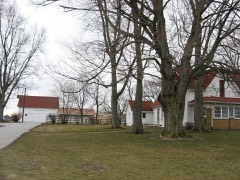
Photograph PropertyDistance Listed
Maplelawn Farmstead1.9 miles2011
Simpson-Breedlove House2.7 miles2016
Brock, Pryor Farmstead2.7 miles2008
Traders Point Hunt Rural Historic District3.5 miles2009
Howard School6.6 miles2009

Sources for this property

National Archives recordThe nomination case file for reference 83000115 in Record Group 79.
Wikipedia articleCommunity-written account of this property, licensed CC BY-SA.
Boone CountyAll 13 listed properties in this county.

Provenance

  • Listing record. National Park Service National Register of Historic Places, listed-properties dataset, current to 2026-05-22.
  • Map join. Address geocoded through the United States Census geocoder, then tested against the published boundary of every sheet in the USGS Historical Topographic Map Collection.
  • How this page is made. Listing fields come from federal records; map-sheet coverage is a labelled coordinate-to-boundary calculation, not a source-field claim.
  • Mines and quarries. USGS Mineral Resources Data System (MRDS) https://mrdata.usgs.gov/mrds/ A work of the United States government, no copyright under 17 U.S.C. 105.
  • Storms. NOAA National Centers for Environmental Information, Storm Events Database https://www.ncei.noaa.gov/stormevents/ A work of the United States government, no copyright under 17 U.S.C. 105. Narratives are quoted verbatim from the National Weather Service report and are not edited or summarised.